Diary Entries in English

Recent diary entries

Posted by mapmyplanet on 22 February 2021 in English. Last updated on 13 April 2021.

Although I am a Pennsylvania resident, I spend a good deal of time in Delaware, exploring natural areas such as parks, State Forests, and Preserves. My hobby is to record the GPX traces for my hikes in order to add hiking paths to OSM. I use OSMAnd for tracking and edit OSM using iD and JOSM.

In the course of recording these map features, I’ve noticed some of Delaware’s public lands in OSM do not conform to the standards expressed in the United States/Public Lands wiki.

I have started a discussion on the Delaware wiki page in an effort to expand the Delaware wiki to specify tagging standards for Delaware’s public lands. My starting point is to work on the State Forests.

I’ve also noted that the outlines some (many?) of the State Forests don’t match the data that can be pulled from PADUS. I am working to resolve this discrepancy.

After the State Forests are corrected, I will move on to address other public lands in Delaware. I invite collaborators.

Location: Downingtown, Chester County, Pennsylvania, 19335, United States

The OSM Foundation started publication of the results of the The 2021 OSMF Community Survey where we can download a spreadsheet with the Comments received in the survey.

In the second section, you will find extracts of individual comments that I interpret as being related to the Question F1 about Diversity and Inclusion Special Committee and complaints about Systematic Offensive behavior in the OSM Community.

But first, if we look at all comments listed, my perception from the comments is that many participants to the survey are looking at the various actors and politics that are played and want to insist on various challenges facing OSM and often concern about the dynamic with the various actors and the various agendas. Note that this is anonymous data, and that comments below are my interpretation reading these.

The participants comment on the various actors and their actions, plus the impact on OSM. We can observe how they are seing political actions and the various actors and they perceive actions including from volunteers, Data Working Group (DWG), Influencers on Tagging discussion, paid and Corporate contributors, local communities and the usage of AI tools, Tagging of Disputed territories, Mechanical edits and Imports and even Non-OSM-Attribution by dominant Corporate actors. The OSM ecosystem creates great possibilities of collaboration and innovation for various products and answers to various needs.But with such dynamics, there are actors that are more in position of power like the Corporate actors, Software developpers or even small groups that control tagging schemes. Contributors like «tagkeepers» using mechanical edit tools have important capacity of action. Democratic play inside OSM means informations, discussions, and way to progress to concensus. But like any other political play, it is not easy to simply establish the facts, and accept to find solution, share powers with others, or accept that others have power they dont want to share.

See full entry

New

Posted by ucnwangwu on 22 February 2021 in English.

Hello! I am new here and happy to become one of you. I was introduced to OSM by Victor Sunday who happened to be my map making mentor and we have done some great mapping work together. I am a member of Unique Mappers Network Nigeria.

uniquemappersteam

#uniquemappersnetwork #uniquemappersteam202

Posted by Stereo on 21 February 2021 in English. Last updated on 22 February 2021.

The raw results of the 2021 OSMF Community Survey have now been posted. One of the questions asked people to rank seven choices for what the board should work on:

In 2021, what do you think should be the priority order of tasks the Board of Directors has set for itself?  Please rank the tasks in order of relative importance to the OSM project.

A vote counting method that’s relatively easy to implement in a spreadsheet on a Sunday evening is the [Borda count]. I’ve done a slightly modified one - an option at first rank gets 7 points, second rank 6 points, etc., until 7th rank gets one point.

The results actually match the results if you rank by first preference. Fund-raising gets high ranks in subsequent preferences, but because it’s not high in the first preference, it ends up in the middle of the final count.

Choice Borda score
Stability of the core infrastructure (hardware, software, human capital) 16591
Takeover protection 11179
Outreach to Local Chapters and Communities 9799
Fund-raising 9529
Attribution guidelines 8307
Recruitment for Working Groups 8299
Brexit 4330

Does anyone want to try a Condorcet ranking?

I mostly agree with that list of priorities.

I hope that I find enough free time to work on hiring our Senior Site Reliability Engineer very soon.

Board members don’t agree on how much a threat takeover is, and how to protect against it - this is definitely something where the members need to make their voices heard. Message me, email the board, post in the comments below.

See full entry

Location: Hollerich, Luxembourg, Canton Luxembourg, Luxembourg
Posted by c tito young on 21 February 2021 in English. Last updated on 11 April 2021.

A geoglyph of a 100m x 100m is of a salmon seemingly leaping out of the water. Drawn as a “side view” the geoglph reveals its long curved body, wide open mouth, eye and tail. The drawing is oriented north to south. The head of the fish points itself north and the tail points to the south.

15°17′13″S, 74°30′37″W -15.2868127, -74.5103940 Acarí, Province of Caravelí, Arequipa, Peru

Location: Acarí, Province of Caravelí, Arequipa, Peru

The anonymized, raw results of the 2021 OSMF community survey have been posted here in .ods format spreadsheets. There are two spreadsheets, one containing anonymized raw data, and the other containing summary statistics calculated from the raw data before anonymization. I believe I have caught all errors made in the initial trials of calculating summary statistics (I had to brush up some long-dormant spreadsheet skills), but will appreciate being notified if anybody reading this notices anomalies or errors in the statistics.

I am continuing to analyze the raw data, and if there are specific requests for cross-sectional analysis not already presented in the summary statistics spreadsheet, please let me know, and I’ll try to fit them into my schedule.

We are working on normalization of the data against mapping activity by country. Since 84% of respondents identified themselves as mappers, this should help us to weight (normalize) the responses by geography. Initial examination of normalization trials revealed, however, that the differences between raw results and normalized results do not appear large. We are therefore proceeding with release of the raw data.

Please feel free to amplify this message via social media and other communications channels and in languages other than English. Many thanks in advance for your help.

Posted by pnorman on 21 February 2021 in English.

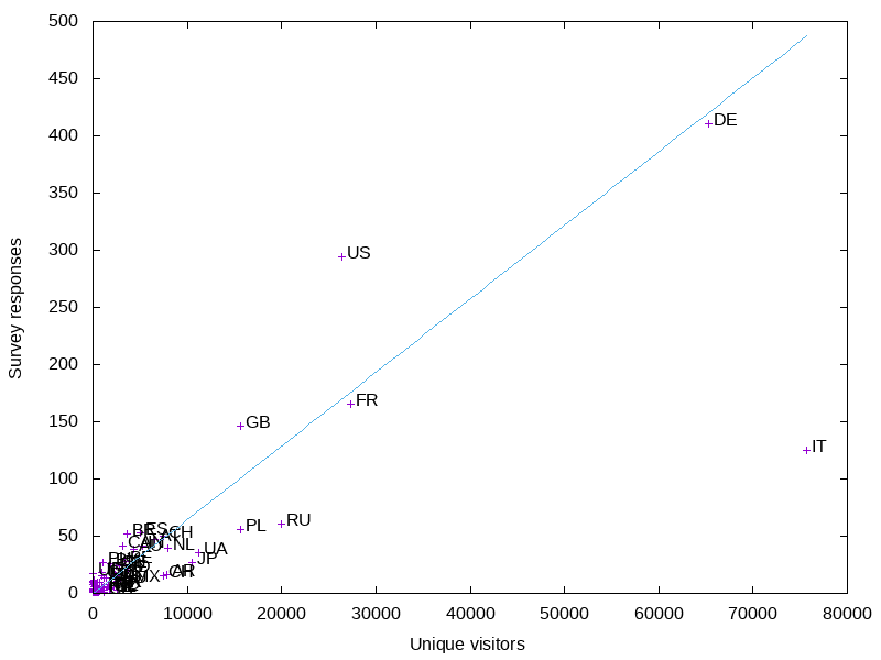
In my last post I looked at survey responses by country and their correlation with mappers eligible for a fee waver as an active contributor.

I wanted to look at the correlation with OSM.org views. I already had a full day’s worth of logs on tile.openstreetmap.org accesses, so I filtered them for requests from www.openstreetmap.org and got a per-country count. This is from December 29th, 2020. Ideally it would be from a complete week, and not a holiday, but this is the data I had downloaded.

Preview image

The big outlier is Italy. It has more visits than I would expect, so I wonder if the holiday had an influence. Like before, the US is overrepresented in the results, Russia and Poland are underrepresented, and Germany is about average.

Like before, I made a graph of the smaller countries.

See full entry

Posted by c tito young on 20 February 2021 in English. Last updated on 11 April 2021.

A geoglyph 150m x 150m appears to be of head of a smiling person, facing west, seems entertained by a parakeet on its hand. The figure is drawn showing two squinting eyes while watching the activities of a calm and relaxed parakeet facing east.. The etching on facial features includes a small stubby nose and a massive jawline. Except for the figures fingers, there is little resolution to suggest a neck or other portions of its body. What appears worn by the figure is partly traced Inca style wool cap with ear flaps. It seems the artist in creating this object in conjunction with the natural features of the terrain. To further express the subject, the artist performed some minimal modifications to the natural surfaces of the rock to create the figure. .

Note that the top of the head of this object falls into a valley, making it appear upside-down or very difficult to see from the ground.

15°17′15″S, 74°30′16″W -15.2874471, -74.5043227 Acarí, Province of Caravelí, Arequipa, Peru

Location: Acarí, Province of Caravelí, Arequipa, Peru
Posted by c tito young on 20 February 2021 in English. Last updated on 12 March 2021.

A geoglyph representing a skeleton (75m length x 50m wide) depicts human bones, face up, with one outstretched arm pointing north. The body lays in an east (head) to west (feet) orientation.
The geoglyph is well reflected in terms of anatomy of skull, spine, ribs, hip, legs and arms with hands. There is a bit of proportional issues with hands, ribs and arms, but the characterization is well defined. The skull is turned sideways, facing south.
Thigh bones measure a good 1m thick. Note that there is a 30m difference in height between the hand pointing north and the foot pointing west. .

15°17′17″S, 74°30′33″W -15.2880744, -74.5092060 Acarí, Province of Caravelí, Arequipa, Peru

Location: Acarí, Province of Caravelí, Arequipa, Peru
Posted by cjpapetti on 20 February 2021 in English.

Hi from Blake Island Above image: Exploring the island with my partner.

My favorite camping spot near Seattle is Blake Island State park because I can literally walk from my apartment to the ferry which drops me off at the campground without any need for a car!

The Blake Island trails are not fully mapped on Open Street Map so I guess that’s my job now? Here we go!

See full entry

Location: Kitsap County, Washington, United States
Posted by c tito young on 19 February 2021 in English. Last updated on 9 March 2021.

Geoglyph of the God of Death, named Supay with an elaborate headpiece with horns. Over 60m wide x 250m long (counting the suggested drawing of his body/robe) he is wearing a pointed beard. He is faces forward with his whole torso tilted slightly oriented north to south. The shape of his head appears triangular with his body hunched below the neckline, wearing a high collar, wrapped in a textured robe holding a smaller animal in his right hand, and carrying a burning skull on a stick on his left hand.
It is unknown the purpose of the geoglyph or that it has some other meanings.

15°17′16″S, 74°30′33″W -15.2878229, -74.5090943 Acarí, Province of Caravelí, Arequipa, Peru

Location: Acarí, Province of Caravelí, Arequipa, Peru
Posted by c tito young on 19 February 2021 in English. Last updated on 12 March 2021.

A Geoglyph of a Moray Eel attacking from his cave 50m x 70m a Sucker Fish 50m x 50, is oriented southwest to northeast. The Eel appears to attack the fish with distinctive jaws and mouth and partly leaves leaves his cave to do so. The Sucker Fish, appears to swim unnoticed that it is being attacked. The eels cave is a suggested as a reef with a hole of where the eel resides, but it is also difficult to determine if this reef has other details showing coral or other nearby fish. This geoglyph is part of a larger group of shapes sharing the same artwork themes.

This suggested image, brings up questions that possibly this culture had skin diving as a form of fishing.

15°17′18″S, 74°30′35″W -15.2883668, -74.5096664 Acarí, Province of Caravelí, Arequipa, Peru

Location: Acarí, Province of Caravelí, Arequipa, Peru
Posted by c tito young on 19 February 2021 in English. Last updated on 15 April 2021.

Less than 5m wide x 5m high, this shaped skull scratched as a geoglyph has two eyes and a disproportioned jaw while oriented north to south. It shares the terrain façade with other geoglyphs identified in this area.

15°17′16″S, 74°30′35″W -15.2877800, -74.5097812 Acarí, Province of Caravelí, Arequipa, Peru

Location: Acarí, Province of Caravelí, Arequipa, Peru
Posted by c tito young on 19 February 2021 in English. Last updated on 10 March 2021.

This 30m wide x 50m long geoglyph is an image that suggests a screaming, calling or yelling head wearing face makeup. Stark eyes faces right at viewer. This head is oriented north to south.

The artwork directed is of a head, that appears like it is calling or shouting. Stark eyes this geoglyph is quite large, almost completely hidden but fully exposed on a steep bluff that drops as much as 10m.

This geoglyph is located on a curve, right above a dirt road, possibly making it very hard to see. Approximately 300m to the north and a secondary group of geoglyphs exist as well.

15°18′12″S, 74°32′51″W -15.3032945, -74.5476281 Acarí, Province of Caravelí, Arequipa, Peru.

Location: Acarí, Province of Caravelí, Arequipa, Peru
Posted by c tito young on 19 February 2021 in English. Last updated on 12 March 2021.

An impression of north to south pointed head geoglyph 25m wide by 150m long is to the adjacent left of a geoglyph head 25m wide x 20m long. The geoglyphs appear close enough to touch each other. They are located on a at the same side of a 40m steep pitched hill.

The first is a pointy head geoglyph, shaped as a carrot, has distinctive two eyes and a mouth. There is little or no indication of a nose. There seems seem to be no indication of neck or body or extremities for this figure. The second is a smaller head has what appears to be two wide looking bugeyes, flat nose and a wide mouth and stops at the lower portion of its neck. There is no ears. The head was drawn just to the right of the carrot shaped head. The details are sketchy but the facial features appear intentional.

To the right of the smaller head are two geoglyph lines that may converge with another geoglyph line. While likely, it there is little confirmation from the satellite images to be certain.

Location: Acarí, Province of Caravelí, Arequipa, Peru
Posted by c tito young on 18 February 2021 in English. Last updated on 2 March 2021.

Several geoglyphs totals an area of 40m x 40m with a King figure 15m wide x 25m long and five different figures each averaging 5m x 5m. The orientation of these figures are north to south and from top to bottom changes elevation 10m. The image suggests a King figure centered and directly over his five subjects. Each of the faces have a lot of expression, though detail is very rough and will take some better backgrounds to fully understand.
The King has a wide faced head and the image suggests that his arms are folded in front of him. He is also suggested to have been wearing a crown. The five figures below him are as follows along with their descriptions. There are visible etchings that suggest bodies and possibly more faces, but they are unrecognizable. Therefore, unless there are more clear images, there is a degree of clarity in whether or not these five (or more) faces have bodies or necks. There is an attempt to show these figures.

Oval head (possible face to its right, possible shoulders and neck)
Triangle head (possible body below its head) Skull head (possible body below its head) Heart Shaped head (possible body below its head) Round face head (possible body below its head)

14°53′5″S, 74°52′59″W -14.8848281, -74.8831564 Vista Alegre, Province of Nasca, Ica, Peru

Location: Vista Alegre, Province of Nasca, Ica, Peru