Diary Entries in English

Recent diary entries

Posted by c tito young on 18 February 2021 in English. Last updated on 10 March 2021.

Etched into a hillside is what appears to be a graphic of a 75m wide x 75m long geoglyph a joyous man, walking wearing a loose fitting v-neck alpaca pancho. He is pointing in front of him and behind him. He seems to be wearing a cap and a scarf. You can see two hands, two feet and facing the viewer and climbing the mountain. His oriented north to south and where he is etched changes elevation of a distance of around 15m;

14°53′19″S, 74°53′46″W -14.8885638, -74.8960171 Vista Alegre, Province of Nasca, Ica, Peru

Location: Vista Alegre, Province of Nasca, Ica, Peru
Posted by c tito young on 18 February 2021 in English. Last updated on 10 March 2021.

An etched geoglyph of the animal called a Capyvara (100m long x 80m wide) in an orientation of east facing west looks as if its eating from the ground. The animal, drawn anatomically correct has the side view unmistakably of the animal. From side view, two legs, head, one eye and body appears. The etching shows the animal while on all four legs, with its head to the ground, feeding. It is unclear what the animal is eating. There also seems little about what might be the reason for the artwork.

14°53′6″S, 74°53′25″W -14.8849783, -74.8901820 Vista Alegre, Province of Nasca, Ica, Peru

Location: Vista Alegre, Province of Nasca, Ica, Peru
Posted by pnorman on 17 February 2021 in English.

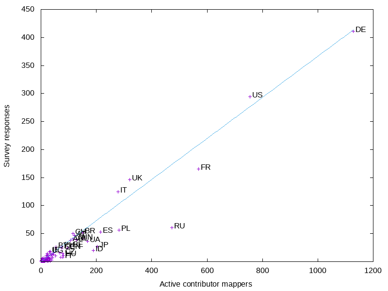
The board has started releasing results from their 2021 survey. I’ve done some analysis on the response rates by country.

There’s lots of data for activity on OSM by country, but for this I took the numbers from joost for how many “active contributors” there are according to the contributor fee waver criteria.

Preview image

For the larger countries, Russia is the most underrepresented country. This is not surprising, as they are underrepresented in other venues like the OSMF membership.

The US and UK are both slightly overrepresented in the survey, but less so than I would have expected based on other surveys and OSMF membership.

The smaller countries are all crowded, so I did a graph of just them.

See full entry

Posted by c tito young on 17 February 2021 in English. Last updated on 12 March 2021.

Multiple geoglyphs of less than 3m-5m can be seen nearby a huge 40m x 40m geoglyph of a cross with a 10m long horizontal line under it. From satellite it is impossible to read what they are clearly manmade shapes. This moderate slopes uphill from west to east and changes about 10m of elevation in 40m of distance. It seems possible that the large cross geoglyph is designed to be visible from one vantage points or other nearby distances.

14°53′14″S, 74°53′44″W -14.8872554, -74.8955639 Vista Alegre, Province of Nasca, Ica, Peru

Location: Vista Alegre, Province of Nasca, Ica, Peru
Posted by c tito young on 17 February 2021 in English. Last updated on 12 March 2021.

Geoglyphs ranging from 200m x 200m to 200m x 600m are of manmade continuous lines that when counting switchbacks easily stretch a distance of over 15000m. These linear geoglyphs lines average 1m in thickness, and also contain 180 degree switchbacks turns that might a single or double line. All the lines aim the similar direction, northeast to southwest and appear in three different sized groupings. The largest grouping has a smaller group within it. The three groups each with lines do not appear connected. Except for vantage points, every grouping of lines are etched in an entire area that is relatively flat.

The middle group, also the largest of the three switchback lines, have a semi-circular 10m diameter platform like geoglyph. This middle group also has what appears to be a ceremonial spot.

Each group of switchback lines have their own viewing/vantage point, where a small berm is provided. It is unclear what might be uses for these viewing/vantage points, but one might assume it is given importance. Each of the three viewing/vantage points all seem to be located northeast of the group of lines and all are approximately the same size. Coordinates are given to each and they are shown on the maps. It might be also worth noting the anything that was a hill may have been a vantage point, but the ones that were selected in coordinates seem to be the closest the the switchback lines.

No. 1 - Ancient Viewing Point -14.5995933, -75.3054811

No. 2. - Ancient Viewing Point -14.6026197, -75.3056850

No. 3 - Ancient Viewing Point -14.6080178, -75.3039053

14°36′21″S, 75°18′12″W -14.6058689, -75.3034485 Changuillo, Province of Nasca, Ica, Peru

Location: Changuillo, Province of Nasca, Ica, Peru

Located: 14°36′29″S, 75°17′10″W -14.6079702, -75.2859769 Changuillo, Province of Nasca, Ica, Peru

As one more into a westerly direction, the questions arise, how much did the Inca come this direction? Are there more as one nears the coast, or less.. do they follow a path? Is there a trail? Is there a change in technique? Were the ones in this area damaged by storms?

We shall see.

Moving the west direction away from Nasca, are there more lines? What is the farthest Nasca line? Why?

Location: Changuillo, Province of Nasca, Ica, Peru
Posted by c tito young on 16 February 2021 in English. Last updated on 17 April 2021.

Multi Linear geoglyphs between the distances of 1.5km and 4km must have been one of the greatest feat the Nasca Lines. In this relatively flat area, lines of 3km score this valleys landscape. Multiple scores reveal sixty separate side by side (5m apart) geoglyphs lines that are etched northeast to southeast in one direction and another twenty in east to west side by side 5m apart in another direction. These geoglyphs crisscross each other creating a massive X shape, that can been seen way up over the earth surface and that they seem to connect one plateau with another. More interestingly and with no real understanding quite why, some of the geoglyphic etchings are geometrically straight lines and others seem to allow deviances with curvature and angles. There are also places where lines drop off and others start Some of the lines tend to become groups within themselves, and thus they become their own shape.

As with other lines and shapes, found in regards to the Nazca Lines, the randomness is becoming more and more predicable. For example, just about every time the are drawing are drawn to point a something…

Cracking this code, as many before me have tried, might one of the following.

1) Getting noticed by Gods 2) Telling a story 3) Calendar 4) Star Charts 5) Indicators of sacredness 6) Mix of Ruins, Geoglyphs and Petroglyphs all in the same area.
7) All the lines aim or start from natural locations, lending more homage to star locations, or solar calendars.
8) Location of underground aquafers, underground streams 9) Possible indicators of property owned

Location: Changuillo, Province of Nasca, Ica, Peru
Posted by c tito young on 16 February 2021 in English. Last updated on 10 March 2021.

In this area a very foggy set of Geoglyph shapes of heads appeared in a row. Did not try to trace them, but just simply count what appeared as heads and circles. Decided to remove this entry. The shapes including some with eyes and mouth may have deciphered but not strong enough, in an area of 90m x 10m in an east to west direction in a rather flat valley. Extremely hard to see, decided to placeholder this for better sat images or delete. .

Awaiting better satellite images.

14°46′58″S, 75°10′21″W -14.7828406, -75.1724646 Nazca, Province of Nasca, Ica, 11401, Peru

,

Location: Nazca, Province of Nasca, Ica, 11401, Peru
Posted by c tito young on 16 February 2021 in English. Last updated on 4 April 2021.

Two large monolithic 30m man made shapes appear side by side. One of the shapes resemble an oblong square with a trapezoid 5m x 5m box sticking out of it with multiple circular depressions with in it. The other shape appears to be a manmade modified geometric shape sticking with a roundish depression on its topside. Both these shapes appear to have some form of modification on them, but for what reason, it is unclear.

Location: El Ingenio, Province of Nasca, Ica, 11350, Peru
Posted by c tito young on 16 February 2021 in English. Last updated on 11 March 2021.

A geoglyph of a giant python snake (210m long x 10m wide) oriented west (head) to east (tail) and located at the top of a large flat hill appears to be slithering away. The sinuous shape of the snake makes an appearance of its body slithering along the ground. It is unclear the reason for this snake, but it could be assumed its direction points to the nearest manner in which to get to the sea.
At the bottom of the hill, to west is another geoglyph called “Gigante”. There are also a few geoglyph shapes at the foot of the hill towards the south.

Location: Nazca, Province of Nasca, Ica, 11401, Peru
Posted by valerietheblonde on 15 February 2021 in English. Last updated on 4 April 2021.

Background

My girlfriend is embarking on a through-hike of the Appalachian Trail (AT) this year and that started me wondering about how the OpenStreetMap US Community organizes itself around maintaining trail systems. Over the past few years I have been working on the Florida National Scenic Trail, more commonly known as the Florida Trail (FT), starting with the rerouting of the FT through Split Oak Forest WEA, the site of my Masters thesis work.

Status in OSM

I have worked hard to map this park in OSM and have completed the FT through the park and up through Moss Park and Crosby Island Marsh Preserve. The trail is not yet connected to the rest of the FT in Central Florida. The FT is mentioned in two places on the Wiki - under the National Scenic Trail heading of the United States/Long distance trails page and the Florida page. The United Sates/Long distance trails page lists a ten National Scenic Trails, one of which links to the OSM wiki (because I just changed it). and the rest link to their wikipedia pages. The PA - Mid-State Trail also links to its own OSM wiki page which is cool because it even has a progress bar! I asked the OSMUS Slack channel if there’s an organized group or effort maintaining the AT and the answer is no, and @datamongers pointed out that the AT is pretty complete, even being covered by a superrelation.

Proposal

I propose that I start out by creating OSM Wiki pages for each trail (Done - FT, AT) and link to them in the United States/Long distance trails page (done).

Then, check for status and completeness of both the AT and the FT including route, closures, trailheads, and shelters.

Trail segment completeness

See full entry

Location: Lake Mary Jane, Orange County, Florida, United States
Posted by c tito young on 15 February 2021 in English. Last updated on 10 March 2021.

A 150m Long x 50m Wide geoglyph of a jumping man oriented north to south situated almost upside-down on a moderately sloped hillside that changes elevation almost 40m. The abstract man, seemingly with an outstretched arm over his head and appears too want to take off in flight.
This depictions suggests using natural formation and etchings to create the face and the geoglyph figure. The jumping man has a triangle shaped head, which seems to be referring to the massive numbers of triangles all over the Nazca valley. The triangle could have some references to the elongated head as well.

Location: Ventilla, El Estudiante, El Ingenio, Province of Nasca, Ica, 11350, Peru

See my previous entry for installation instructions.

So far, mapillary_tools has worked very well for me! Images are sent to Mapillary MOSTLY facing the correct direction, with duplicates (from stopping at intersections, and such) being removed. The work I must do afterwards has been cut dramatically. This makes wandering to new places to capture images a fun adventure for me, and makes editing OSM with captured images + GPX a lot smoother of a process.

I capture images at 1 per second in a vehicle (any faster, and my GPS gets wonky), or 3 or 5 per second while hiking. I use pretty harsh duplicate detection, since my phone’s compass is terrible, and my GPS wanders anywhere in a 1m range while I’m stopped, given enough time. My favorite command to run is:

mapillary_tools process –import_path storage/dcim/Trip1 –cutoff_time 30 –duplicate_distance 1.5 –duplicate_angle 360 –interpolate_directions –offset_angle 0 –overwrite_EXIF_direction_tag –user_name jesseakaraccoon –advanced

Results look good!

The part “–interpolate directions” is like using “normalize sequence” while editing. It’s not perfect, but it’s great! I’ve reported a minor flaw, which causes some images at stops to point in odd directions.

Location: Broadway, Eureka, Humboldt County, California, 95564, United States

Personally ,I think it is best to use Bing Imagery for adding new things to the map as it is often has the most up to date imagery ,but if you are adding things that were always there IRL but not on OpenStreetMap(In the UK), then you should use OS OpenData Streetview.

Location: Thomas County, Kansas, United States
Posted by c tito young on 14 February 2021 in English. Last updated on 15 April 2021.

A geoglyph of what appears to be a 75m x 75m seabird on a slightly sloped 10m elevation difference in the hill. With its beak facing northeast and tail facing southwest, this sideview manmade geoglyph displays a bird and wings in flight head, long beak and one eye. Also visible are the suggestions of feathers and differences between head, body and wings. The seabird bird is less than 3m from the bird of which it attacks.

14°52′35″S, 74°55′35″W -14.8763590, -74.9263191 Vista Alegre, Province of Nasca, Ica, Peru

Location: La Primavera, Vista Alegre, Province of Nasca, Ica, 11401, Peru

You can install mapillary_tools on an Android device without rooting it. Here was my process:

Start by downloading Termux, a good command line program for Android.

Then, install mapillary_tools according to Linux instructions on the README. However, because Python 2 is no longer supported, the “pip” command seen in the readme will not work.

Use the command…

pkg install python2

…to install the necessary version of Python. Then follow instructions as-is, but replace instances of “pip install” with “python2 -m pip install”

Finally, on Termux, you must run the command “termux-setup-storage” to access the device’s internal storage.

As a non-programmer, this took me a while to figure out. I hope this helps someone!

In August of this year, 2021, the YouthMappers, Universidad de Panamá (Jóvenes Mapeadores de la Universidad de Panamá) will celebrate its fifth year. As we celebrate this milestone, it is almost impossible not to think about the challenges we have overcome and the numerous successful accomplishments. In 2016 Dr. Patricia Solis cofounder of the YouthMappers contacted me to tell me about this important project where, using Open Street Map (OSM), students could connect their peers from around the world, mapping communities and areas with the purpose of revealing the hidden, to give the voiceless a voice.

I had worked with Dr. Patricia Solis and Dr. Marie Price a couple of years earlier, collaborating on a study abroad program here in Panama where we were able to bring together students from George Washington University and the University of Panama to work on a project in the Historic District. It turned out that our students from both universities were excited about this experience and created ties of friendship that continued after this project.

To me, this experience showed me that we needed to focus more on trying to find these spaces where our students could expand their academic knowledge and be able to listen to other experiences and participate with other students in solving real life problems that could change in some degree other people´s lives. So, I thought that begining a YouthMappers chapter would be a great opportunity, to encourage students to participate in this voluntary initiative.

To begin this process, I talked to my colleague Professor Humberto Smith and others to help me in this task. Although for some colleagues it was difficult to get involved due to their busy schedule, they tried to help us spreading the word among students. Professor Smith and I decided to continue this endeavor, and we were able to motivate a group of students who helped us to create the YouthMappers, Universidad de Panamá chapter.

See full entry

Posted by c tito young on 13 February 2021 in English. Last updated on 10 March 2021.

A geoglyph of a giant head 50m wide x 100m long, oriented north to south, is part natural feature and man-made modifications hidden in a steep hillside with a change in elevation of 40m. Its drawn view give an impression of a huge grinning smiling person with long hair. It has shifty half closed circular shaped eyes, with its face accented in a split tone of dark and light. The giant head’s shape appears abstract, elongated and thin.

Southeast of this artwork is the famous “Hummingbird” geoglyph just 200m away.

Location: entrada al ingenio, San Miguel de la Pascana, El Ingenio, Province of Nasca, Ica, 11350, Peru