Diary Entries in English

Recent diary entries

Posted by PhysicsArmature on 27 April 2020 in English. Last updated on 4 January 2022.

Problem:

I need to slap down one set of 50 houses. I want to click as few things as possible. Script 1 is about this task. Script 2 is about finding the coordinates of things on your screen.

Notice: Eliminate [] before the pound sign, I needed to differentiate kramdown and BASH code. Notice 2: I have this weird spacing, otherwise journal system tries to turn a script into a paragraph.

SCRIPT 1

[]#!/bin/bash

[]#pull up script

sleep 4

[]#0.1 is to fast

for i in {1..49}

do

echo -e $i

[]#Find a house and click on it yourself

[]#Go to xy of use this feature xxxyyy

sleep 1.8

xdotool mousemove 35 243 click 1 &

[]#Go to xy of change this feature

sleep 0.3

xdotool mousemove 53 211 click 1 &

[]#Go to xy of option 1 house

sleep 0.3

xdotool mousemove 51 276 click 1 &

done

echo DONE

SCRIPT 2

[]#!/bin/bash

[]#pull up script

sleep 5

for i in {1..200}

do

xdotool getmouselocation –shell

eval $(xdotool getmouselocation –shell)

echo $X $Y

sleep 5

done

Works used:

https://stackoverflow.com/questions/8480073/how-would-i-get-the-current-mouse-coordinates-in-bash https://askubuntu.com/questions/179581/how-can-i-make-my-mouse-auto-click-every-5-seconds

Potential future targets for when I have time (Not for 2 weeks):

  • Another for loop for several sets of 50.
  • Search for the color pink on the screen and click it. Ask [Y/n] on the command prompt, then mark it.
  • Custom input that asks for pauses.
Location: Saint Cloud, Stearns County, Minnesota, United States

8055 - Allahabad Buildings, Kaushambi - Uttar Pradesh

For every year that a girl is enrolled in school, she is more likely to avoid early marriage and to survive childbirth. She will be less likely to suffer domestic violence, or be trafficked, and will have a higher future income. She will have a smaller, healthier family and will be 50% more likely to immunize her kids. She’ll leave her mark on future generations, as climate scientists rank girls’ education as number six out of 80 actions that can reverse global warming. And she’ll be twice as likely to educate her own girls — keeping the cycle going. Yet despite all these proven economic and societal benefits, across the globe, millions of girls are still excluded from school because of their gender. India is home to one of the largest such populations, with more than 4.1 million girls outside the classroom. Educate Girls are supporting 1.6 million girls in rural India to gain access to education, and you can help them by mapping and validating villages in rural India.

Spent 1 hour mapping buildings.

(Canonical version of this post is on “Sports in Ireland & Britain” on Technomancy)

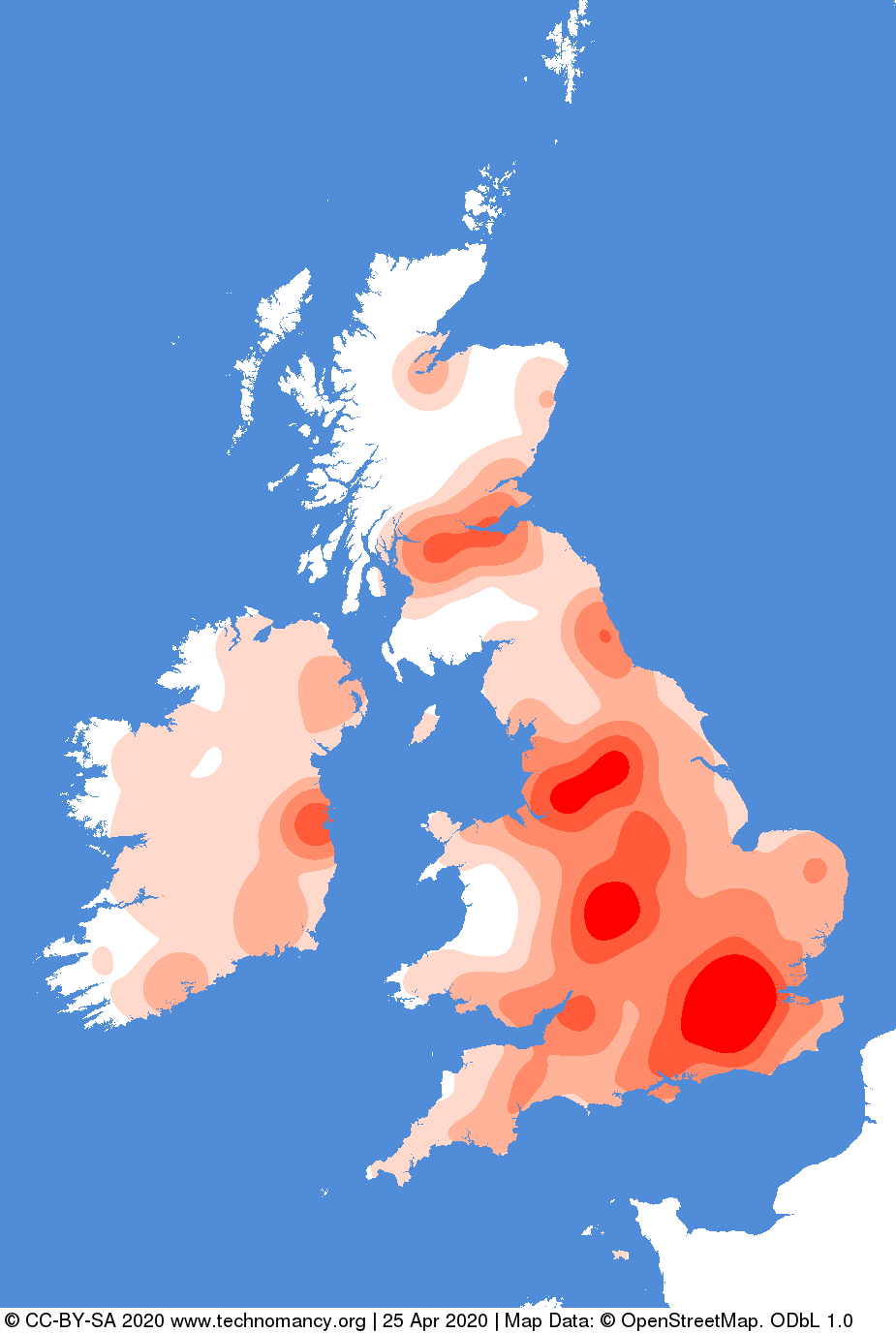
I created some software to generate heatmaps from OpenStreetMap, here’s what OSM’s sport tag looks like for t̶h̶e̶ ̶C̶e̶l̶t̶i̶c̶ ̶I̶s̶l̶e̶s̶ Ireland & Britain

When you have checked out the code from Sourcehut (or Github), then run make build-deps to install requirements.

Then download the data:

$ make data-ireland-and-britain

Look at the spread. Initially I ran it withouth steps=..., and tried different values until I got something that looked nice.

$ make heatmap_key key=sport steps=0%,1.5%,4%,10%,22%,35%

Shows this:

Unsurprisingly, this shows urban populated areas. On average Britain, even rural areas, have a higher score than rural Ireland. It’s hard to know if that’s because of less mapping in Ireland, or less sporting facilities, which might show a difference in cultures.

Let’s see what’s popular:

See full entry

Posted by EdoBoo on 25 April 2020 in English.

Hi all,

In the past days, i concluded the mapping of Bonafus, a big zone outside the city of Chieri (TO), within which there are two different schools and other services, like the experimental winery of University of Turin and a private school of gardending.

I completely mapped the land use and i add a lot of details, road, pedestrian routes, buildings etc.

The result is this: Complete zone

See full entry

Location: Bonafous, Chieri, Turin, Piedmont, 10023, Italy
Posted by KingVik on 25 April 2020 in English. Last updated on 2 May 2022.

UniqueMappersTeam Nigeria had Webinar training so that we can learn while staying safe.

Held Time: 3PM

Topic: Mapping with field paper and OSM

Date: 24th April 2020

Venue: UniqueMappers Nigeria Zoom Room

Zoom ID: 4602723253

Trainer: Chukwu Kingsley & Anointing

Organizer: Unique Mappers Network Nigeria

It was really nice training where the attendees learnt how to use Field Paper when there is no drone for mapping.

Thanks to UNIQUE MAPPERS NETWORK NIGERIA

Posted by prispe on 24 April 2020 in English.

I am so happy that am a member of OSM community and a leader. Reason for this; because of the state of the map Africa I attended last year at Cote D’ Ivoire. I was opportune to interact and have a snapshot with Stave Coast the founder of OSM. Although, the journey was rough but, I was able to make it. After my interaction with other members of the community(OSM) my horizon was broden and I help to grow the Uniquemapper network of Nigeria by searching out the non student and students in other tertiary institutions in which preparation was ongoing before this pandemic outbreaks.

Posted by alexkemp on 24 April 2020 in English. Last updated on 28 April 2020.

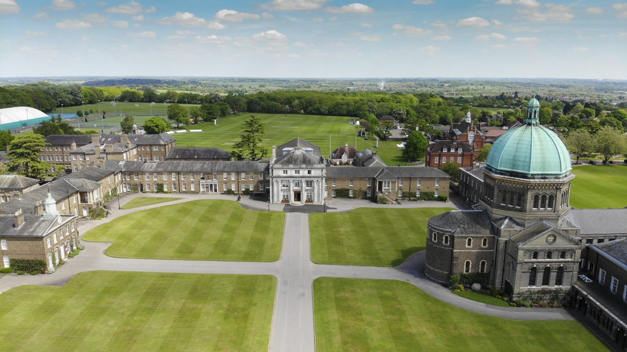
My last Diary was a HowTo on using JOSM to create a Relation to map Heath Mount School. Heath Mount was founded in 1796 & occupies 40 acres of the Woodhall Estate close to Ware in Hertfordshire. Now, just to show that some people & places may be created more equal than others, here is the Haileybury and Imperial Service College, which is also close to Ware & occupies 500 acres. This one has been a little bit more of a challenge to map.

drone footage

Haileybury College (OSM map)
Haileybury College (OSM relation - 130 members)

The bulk of the mapping is complete for this College (85 different items so far) but lots of buildings still to follow.

First a quick bio, then mapping highlights:

See full entry

Location: 51,779, -0,034
Posted by KingVik on 24 April 2020 in English. Last updated on 2 May 2022.

Ogrute Enugu Ezike Mapping Task.

Ogrute Community is the epicenter of Ugwu Eru Hill that produces more than 13 edible mushroom seasonally in Enugu Ezike ,Enugu State ,Nigeria. Open Data mapping for this community would provide critical geospatial data to drive global open data access for agriculture and nutrition . Global Open Data for Agriculture and Nutrition(GODAN) ,government agencies and agricultural stakeholders requires data to measure the targets of SDG 2 for Zero hunger and food security.

Unique Mappers Network is a Community NGO for OpenStreetMap Project in Nigeria driving Open data mapping for Humanitarian Disaster Response and Economic Development.

This project provides community engagement led by Victor N Sunday as national coordinator of UniqueMappersTeam

I, Chukwu Kingsley Chika as Team leader of LionMappersTeam Enugu of UniqueMappersTeam Nigeria

Nnaedozie as UniqueMappersTeam Yola

Chidubem, Kelvin and Chisom from UniqueMappersTeam Pot Harcourt

And UniqueMappers members in different parts of Nigeria to Map for #SDG2 Food Security in Nigeria.

The Mapathon took place on 17th February 2020 Barely less than 48 Hours of launching Ogrute Enugu Ezike task, we mapped it 99%.

Open Data Mapping is critical to driving a measurable target of #SDG2 for Agriculture and Nutrition. Without free and accessible Open Data ,food security at local and global level cannot be achieved !!

Task ID: https://tasks.hotosm.org/project/7932#bottom

Posted by kiggudde on 24 April 2020 in English.

In 2015, as I was winding up my undergraduate program in Quantity Surveying with a focus on the introduction of drone technology in construction, my supervisors at the time Mr. Ondongkara and Mr. John Richard Otukie asked me to attend a presentation from an organization (HOT) that was carrying out mapping and drone imagery capture in Dar es Salaam in Tanzania.I was intrigued and very much zealous to attend the presentation as my information on drone technology at the time was very limited to the few books and videos I had read online.

Long story short I attended the presentation, joined the Mapping financial inclusion training and mapping exercise Eastern Uganda. At the end of the project, I was offered an opportunity to work with the HOT as a volunteer, then the GIS internship followed suit. Over time I transitioned into a mapping supervisor then operations manager for Uganda and now as a project manager in Uganda.

During my time with HOT, I have been involved in various projects that include mapping for financial inclusion, setting up youth mapper chapters, mapping to eliminate malaria across 5 countries in Southern Africa, mapping refugee settlements in Uganda to assist UNHCR and OPM in planning for the response. I and a couple of colleagues also started OpenStreetMap Uganda better known as MapUganda a local OSM mapping community that has now grown into a national registered entity NGO promoting the collection and use of open data and mapping with OpenStreetMap at its core.

Getting involved in HOT has not only provided me with more knowledge and skills in mapping but also in managing, organizing, and relating to persons from other parts of the country and the world. HOT has also provided me with an opportunity to critically understand the landscape of my country Uganda through the various data collection and mapping activities.

See full entry

Location: Buwaate, Wakiso, Central Region, Uganda
Posted by SunCobalt on 23 April 2020 in English.

When I start using OSM’s website, I must agree with the Terms of Use with 2873 words, already exceeding Instagram’s Terms of Use which comes with 2622 words.

In OSM’s Terms of Use I am pointed to the Privacy Policy with another 3409 word. Then I should read the Copyright and License website with 607 words. This site explains that OSM’s data is licensed under ODbL with 4148 words and the tiles are made available under CC BY-SA 2.0 with 2221 words. It also explains that OSM has a Trademark Policy with 3256 words. If I have not given up and decide to contribute to OSM, I must agree on the Contributor Terms with 883 words.

With a subtotal of appr 17.3k words, we have exceeded the US constitution with 4543 words, the US Bill of Rights with 7591, Macbeth from Shakespeare with 17121 words and Microsoft’s ToS for its entire suite of products having 15260.

Let’s assume you like experimenting with OSM and set up a website with a map and some OSM based services around…just for demonstration. You are expected to read the Tile Usage Policy with 651 words, the Nominatim Usage Policy with 601 and the API Usage policy with 488. If you are starting, you probably don’t need to care about the Banner Policy with only 284 words and the New Tile Layer Policy with 399.

After you are through all of that but before you start editing, you should making yourself familiar with the non-legal guidelines such as for Mechanical Edits and Import (maybe more), and if you want to join discusssions with the community there exist a draft for the Community Code of Conduct and you should consider reading the Etiquette and Suggested code of conduct for OpenStreetMap Mailing lists

Is it planned to create a “Legal Planet File” will all the text and made a minutely replication possible as with so many documents chances are high that one changes?

Posted by KingVik on 23 April 2020 in English. Last updated on 17 November 2022.

Event for UniqueMappersTeam International Women’s Day and Open data day celebration

Venue:UBA hall of fame, University of Nigeria Nsukka

Time : 11 am

Date: 7th march 2020

Attendance: more than 150 participants

Organizer : UniqueMappersTeam Nigeria led by National Coordinator Victor N Sunday

Chapter: LionMappersTeam Enugu Campus and Nsukka Campus

As LionMappersTeam leader Worked with Unique Mappers Network,Nigeria National Coordinator(Victor N.Sunday) to Faciliate IWD2020 to Reactivate

Posted by KingVik on 23 April 2020 in English. Last updated on 24 April 2020.

Mapping with Mappilary

Date: Mon. 20th April 2020

Time: 3pm

Trainer: Chukwu, Kingsley Chika

Moderator: Chukwudubem

organizer: Victor N Sunday Venue: https://us04web.zoom.us/j/4602723253

Meeting ID: 460 272 3253.

I Trained more than 15 Webinar Attendee on How to Map with Mapillary -Unique Mappers Community Webinar Training -#COVID19Nigeria We learn while staying safe. It was really great experience.

Mappilary! Making better maps, Access street-level imagery and map data from all over the world. Fill in the gaps by requesting new coverage or capturing your own.

Thank You @Uniquemappers Nigeria for #COVID19 April Community Webinar Training

Posted by KingVik on 23 April 2020 in English. Last updated on 24 April 2020.

Mapping with Maps.Me and MapSwipe

Date: 17th April 2020

Time: 3 pm

Moderator: Lillian

Trainer: Nkechi

Organiser: Victor N Sunday

Venue:https://us04web.zoom.us/j/4602723253

Meeting ID: 460 272 3253.

Trained more than 10 Webinar Attendee #COVID19Nigeria Thank You @Uniquemappers Nigeria for #COVID19 April Community Webinar Training

Posted by TheSwavu on 23 April 2020 in English.

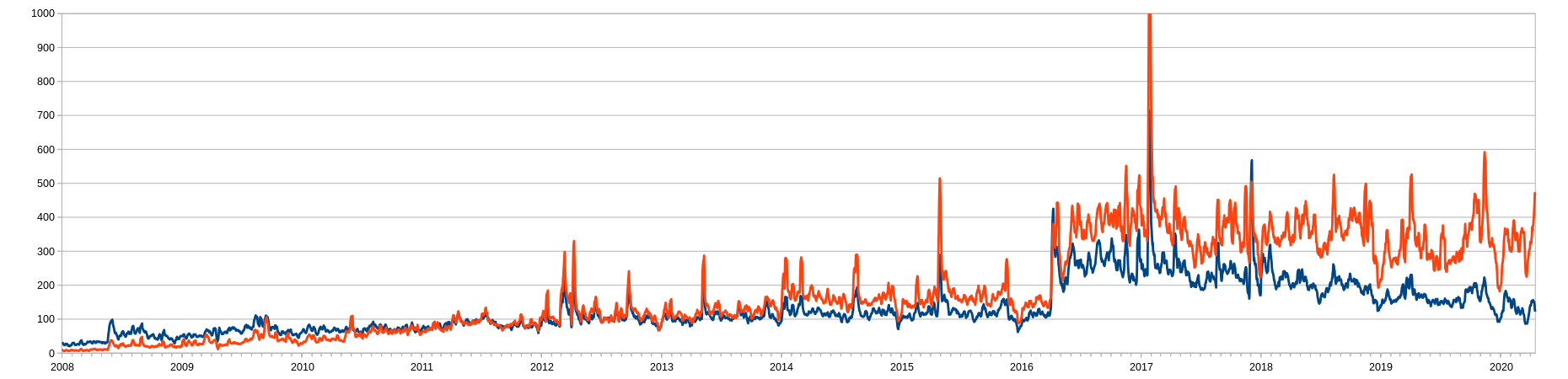
After wondering about recent trends in the number of new user accounts being used, I decided to see what the longer term history of new account creation was.

I have spilt the accounts into two groups:

  1. Single day accounts (red): accounts that have only been used on one day.
  2. Multi day accounts (blue): accounts that have been used on two or more days.

A seven day moving average has been applied because there is a weekly cycle to account creation.

The up tick in single day account use is probably due to the fact that the users haven’t had time yet to come back for their second day.

Graph of new user accounts

Given the COVID-19 pandemic, even though Turkmenistan has reported no cases, I spent part of this week checking the tags of hospitals and clinics in that country to make sure anyone using OSM data could find the nearest hospital or clinic, if it is in the OSM database. Overpass Turbo came in very handy for this exercise.

After completing that task, I started tinkering with Overpass Turbo and pulled up the hotels in Turkmenistan. In Mary I discovered four different locations had been entered in the OSM database for the Soviet-era Sanjar Hotel. Only one could be correct. Fortunately I found a ground-level photo of both the hotel and its associated cafe among the Mapillary images I had collected in years past, and so was able to identify the correct buildings for hotel and cafe, and delete incorrect tags from the others (one of them is the Mary province tax office–hardly a good place to spend the night).

Location: Muhadow, Mary City, Mary Region, 745400, Turkmenistan
Posted by Endres Pelka on 21 April 2020 in English. Last updated on 3 August 2022.

While visiting my hometown in June 2019, I made a day trip to nearby Głuchołazy, to register the routes and stops of the local buses.

I got to do the edits first in April 2020, though. Meanwhile, some things changed in Głuchołazy: another company overtook the local transit, some new lines appeared and the existing lines’ numbers changed. When editing, I used the most current timetables from the town’s website.

I only worked out those lines, for which I knew where the bus stops are: either from my own data from last trip, or already entered by other contributors, or from aerial photos and my best guesswork (with a fixme when in doubt). Unfortunately, local transit carriers don’t care much about publishing the coordinates of their bus stops; we can be happy if there’s any form of timetable on the web. Who cares bou’ tourists, duh…? All de village’s dudes already know, where da damn bus stops. We, the OpenStreetMap contributors, can add this information and help some travellers from getting lost.

By comparing the official timetables and my GPS traces, I spotted a mistake. During the trip with line number 6, the bus took a slightly different route than the official timetable would suggest. Therefore, this line’s relation in OpenStreetMap resembles the facts from first hand, not the official info.

Tagging convention

When mapping the bus stops, I assumed the simplified approach to PTv2. Briefly:

  • The position at which the passenger boards (flag, platform) gets mapped as public_transport=platform, highway=bus_stop with name and details known. On bus stations with multiple numbered platforms, the number goes in local_ref.
  • Not mapping public_transport=stop_position at all.
  • Avoiding the mapping of stop_area relation; both in ÖPNVKarte as well as in Transport Map, same-named stops in close proximity are automatically grouped.

See full entry

Location: Głuchołazy, gmina Głuchołazy, Nysa County, Opole Voivodeship, 48-340, Poland