Diary Entries in English

Recent diary entries

Posted by alexkemp on 21 April 2020 in English.

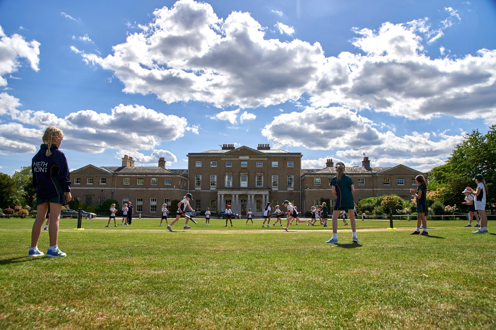
Was it only yesterday that I finished NG school updates, then started working through schools within SG postcodes? For some reason I hit a couple of complex multi-site schools straight away, each of which gave mighty problems. The most recent was the fabulous Heath Mount School (incongruously the relation looks like a fish swimming to the left). My grandkids were due to attend that school until parental divorce intervened.

I find that documenting stuff helps to cement the lessons learnt, as well as giving me something to refer to if I forget, and hopefully will help other novices as well. So, here are some small techniques to use with JOSM to help get the job done, drawn from very recent experience.

School Layout: Look for an Architect PDF

Heath Mount School: osm.org/relation/11018342
Heath Mount School

See full entry

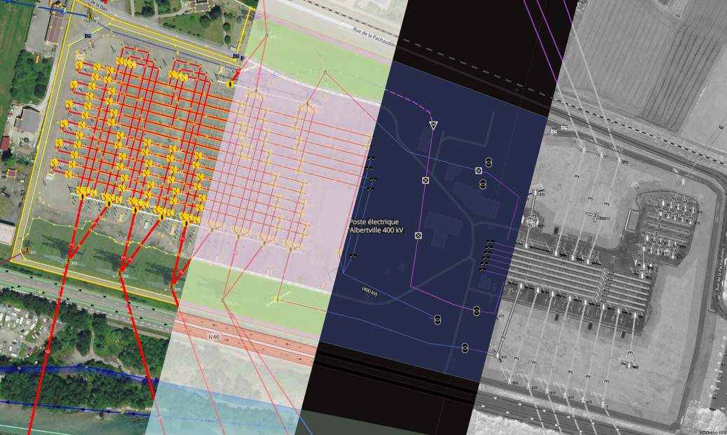
Power network digital twin Following a published article months ago, French OpenStreetMap community reached a step in the beginning of 2020 regarding cartography of highest voltage levels, 400kV and 225kV, power networks.

Contributors had been busy, providing valuable and detailed data for years since 2008 in many places in France. This now enables to assemble this knowledge to provide an elaborated digital twin of French power transmission network including routing capacities to get paths followed by electricity over networks. It is hard to reflect years along people engagement in a single article, but all of this has been a singular human collaboration for which we should be thankful.

See full entry

Posted by AmeliaMap on 19 April 2020 in English.

8287 - Missing Maps - Malawi- ChitipaNW

The Missing Maps project aims to map the most vulnerable places in the world (affected by humanitarian crises: disease epidemics, conflict, natural disasters, poverty, environmental crises). Building on HOT’s disaster preparedness projects, the Missing Maps tasks facilitate pre-emptive mapping of priority countries to better facilitate disaster response, medical activities and resource allocation when crises occur.

Spent 2 hours mapping buildings.

Posted by apm-wa on 18 April 2020 in English. Last updated on 19 April 2020.

Background

Shortly after the new year began, the OSM Foundation chair started contacting members of the OSM community writ large to collect information on the state of the community and project, and to assess attitudes toward the Board’s work. Most conversations were confidential in order to ensure that respondents would speak openly, frankly, and honestly (and it is the chair’s sense that virtually all of them did, and in fact some of them were quite brutally frank about the Board’s perceived shortcomings). Thus, this report will not detail “who said what”. It will, rather, tend more to aggregate viewpoints expressed during the conversations, with illustrative but unattributed quotes.

The chair began by polling members of the Board of Directors of the Foundation, and expanded to members of the Advisory Board, including both corporate members and local chapters. The latter tended to be conference calls with multiple members of those chapters. These calls generated recommendations that the chair talk to pillars of the OSM community or representative members of a tribe (e.g., software developers), so the chair reached out to those individuals as well. Another result was outreach to local communities not formally affiliated with the OSMF, and those conversations proved to be among the most fruitful. The chair held one conversation with a local community and two with corporate representatives face to face due to the happy coincidences of parties being in the same geographic location.

This effort is not over. If anything, the conversations revealed a desire for better communication between the Board and the community’s various tribes (including working groups), which can only be satiated by making the effort to reach out, to schedule calls, then just to call. Geographic coverage of the current outreach effort remains a work in progress; to date the chair has made no calls to Latin America, for example.

The Top Lines

See full entry

Posted by AkuAnakTimur on 18 April 2020 in English.

I’m not sure why the OSC plugin for JOSM is really buggy on my machine (Xubuntu 18.04.4 LTS) so I browsed its website instead.

But sometimes the website itself dragged Firefox to crawl and once in a while, freezes the whole system (but I was able to get back to editing without losing data). Mapillary never did something like this.

So I disabled the hardware acceleration on Firefox. Looks like it’s working well so far.

Today was the first public OSMF board meeting with video and i thought i’d share a few observations on it.

As background - i had made some general comments on what things would deserve consideration regarding the form of board meetings as well as some more specific concerns regarding the form of hosting for the communication platform. It seems there were some difficulties in understanding that for the board due to differences in the timeframe we looked at the matter on - my considerations were largely long term (read: several years) while the board members seemed to look at it more short term in terms of the next few months.

Anyway - here i am going to share my practical observations, which is probably more strait away to understand.

The newly introduced platform seems to work fairly well - i have not measured the bandwidth requirements so i can’t really tell about that quantitatively but obviously having videos from seven participants being available to you is going to be quite demanding.

As a website running on the web browser this platform has the advantage of not requiring you to install a specific software. OTOH the usability on devices with small screens, in particular phones, is probably severely limited. I also could not find a way to select the microphone to use from within the app. If anyone knows how this can be done please let me know. But obviously this is a minor issue.

If i compare it in terms of audio quality with Mumble i would say it was somewhat worse - but not bad. This assessment is slightly difficult because the use of a video based system has led all participants to set up in a room with a desktop computer or laptop and most with a headset while on Mumble many participants often used a mobile phone. This has a positive effect on the audio quality but that is independent of the platform of course.

See full entry

Posted by Jason_Brown on 16 April 2020 in English. Last updated on 17 April 2020.

I saw that an user edit these islands to what China call it (Xisha Islands) . But this arena are a disputed sea (see https://en.wikipedia.org/wiki/Paracel_Islands and https://en.wikipedia.org/wiki/Spratly_Islands for detail). Please some mark this as disputed area.

Why am doing this? Because if I am not, @SomeoneElse_Revert will keep revert this area.

Posted by Wylbur on 16 April 2020 in English.

I’m embarking on a significant local neighborhood, to combat my condition of being quarantined to home during the Covid-19 epidemic. My goal is to map my local neighborhood in significant detail.

My approach is to trace all buildings onto a given block, then creat a field paper for said block, then walk and collect all address, then input all those addresses. Blocks will be finished when all houses have addresses, and all exterior sidewalks are added.

If you would like to join me in mapping adventures, reach out! It’s an amazing time to work on the map!

Location: King Field, Southwest, Minneapolis, Hennepin County, Minnesota, 55409, United States
Posted by Buster452 on 15 April 2020 in English.

Lately I’ve been on this kick with bicycle riding through neighborhoods, getting GPX traces and documenting the footpaths through neighborhoods.

I also have been messing with Mappillary and OpenStreetCams on my bicycle rides to see how I might use them in a larger way.

Of course I as I virtually wander through neighborhoods documenting their footpaths, I stumble on playground and other amenities and document those along the way.

It’s really nice when I have an area complete and I’m riding through on my bicycle using OSMAND+ application on my phone and get to see and navigate some of my work.

Posted by Valor Naram on 14 April 2020 in English. Last updated on 8 May 2020.

Journey and Beyond

OpenStreetMap

What Wikipedia is for open knowleadge is OpenStreetMap (OSM) for open map (spatial) data. Through the hands of thousand and billions the project aims to create a detailled map of the world. Every single person can help to make sustainable improvements to his or her favourite navigation system or map provider if they use OSM as a source. OSM enables person just like you and me to make a difference, without relaying on government and companies. OSM lives the Community Spirit. Your changes are visible to our database thousand and billions relay on in just some seconds. This allows you to see your changes alive directly after upload.

Problems

The project OpenStreetMap has serious problems like

  • some mappers not listening to data customers or ignoring their opinion directly,

  • missing proper communication/exchange between stakeholders (mappers, developers, organisations, companies, initiatives, (governments) ),

  • negative energy against companies working on the OSM project,

  • non-orthogonal tagging,

  • use of two or more tags for the same purpose,

  • lack of proper tagging documentation (some really good experienced mappers and good writers at the same time do it right),

  • mappers actually do not consult others before creating a new key/tag and not documenting it properly (e.g. Key:diaper . We still suffer from the damage the key diaper imposed)

  • lack of appearance in various Mainstream presses

Strengths

The project OpenStreetMap has also serious strengths like

See full entry

After a long period of work, i’ve concluded the mapping of Pecetto Torinese, a small village in the Turin hills. Before my work, the village it almost didn’t exist: there were only the streets, the plazas, the church and some building near it.

I mapped:

  • The urban area
  • All the buildings
  • The sidewalks and pedestrian routes
  • The schools and the sports center
  • The parking lots and a lot other details

Now, this is the results, i’m pretty proud of it: Pecetto completed

Location: Albera, Pecetto Torinese, Turin, Piedmont, 10025, Italy
Posted by alexkemp on 13 April 2020 in English. Last updated on 23 April 2020.

March 24: School Work starts
April 2: School Work update

Across the last 23 days of this Covid-19 Lockdown I’ve made 526 changesets, almost all updating schools & colleges in the NG UK-postcode area. I’ve been working my way down the osm.mathmos.net website page for NG from top to bottom, and am about ⅔ of the way down. The last entries added were 11 campuses for Nottingham College. This diary entry is an attempt to synthesise the intelligence gathered so far.

The definitive list of schools, etc is maintained by the UK government & published at School Information Service. Each school is given a unique URN. The OSM reference to relate to this is ref:edubase=URN-Number.

Where you see the word “School” below it also refers inter-changeably to “Colleges” or “Universities”.

1. Use a Roundabout to Align the Imagery

We have a number of different imagery available to use, but all of them both need to be aligned to the ground truth & every time the map location is changed each may need to be re-aligned. The simplest & best way that I have found to do this is to zoom in on a mini-roundabout, and to align the Offset to that roundabout.

The overview is like this:
Satellite view & GPS coordinates need to be aligned to each other based on a vast array of factors: eg angle of view, ground height above sea-level, GPS coordinate system, etc.. It is made more difficult because individual tiles may come from a large range of dates and/or satellites. It would also be wonderful if all of that had been pre-processed between the native image & production of tile-to-view, but we are beggars & not the paymasters & are lucky to have any imagery to use at all. Fortunately, we Brits are obsessed with roundabouts and there is always one close to where we are mapping. Further, OS street-mapping from the government has been imported for all Britain.

Here is the process step-by-step:-

See full entry

Posted by Immortal Boredom on 12 April 2020 in English.

I presume it’s a breach of copyright if I use their satellite or map data? I’m not planning on doing so: I just saw the possibility to do so and I thought it would be a bad idea.

Furthermore, what happens if the data coincidentally happen to be the same? For example, if ‘Long Beach Reserve’ is the correct name, but also appears on Google Maps, is that some sort of breach (can they get you in trouble)?

One last thing: I plan on using data from my government for OSM to ensure accuracy. Here’s the website: https://mapshare.maps.vic.gov.au/vicplan/ Would this also be a breach?

Gotta kill time somehow, Immortal Boredom.

Posted by AmeliaMap on 12 April 2020 in English.

8287 - Missing Maps - Malawi- ChitipaNW

Missing Maps Requesting organization: Netherlands Red Cross The Missing Maps project aims to map the most vulnerable places in the world (affected by humanitarian crises: disease epidemics, conflict, natural disasters, poverty, environmental crises). Building on HOT’s disaster preparedness projects, the Missing Maps tasks facilitate pre-emptive mapping of priority countries to better facilitate disaster response, medical activities and resource allocation when crises occur.

Spent 2 hours mapping buildings, roads & waterways.

Posted by ExpresswayDave on 11 April 2020 in English.

I finally got around to fixing the Greenbelt Bikeway in Heritage Park in Champaign. Notable edits:

  • Cutting off the section that goes over Copper Slough to reconnect to the loop around Kaufmann Lake. This doesn’t actually exist as part of the trail, and is in fact a steep incline. I’m guessing so many people have been using it to go between the abandoned section of the Greenbelt Bikeway and the loop around Kaufmann Lake that to whoever was using satellite imagery it looked like a dirt path.

  • Speaking of the abandoned section, added the way of the abandoned section of the Greenbelt Bikeway that went in the tunnel/culvert along with Copper Slough. Yes, the Champaign Parks District built a cycleway that shares a tunnel/culvert with a creek and then made cyclists forge the creek to continue on what was then the concrete cycleway. It should be no surprise that this section of the trail is completely unusable thanks to all the water damage over the years. I tagged it with abandoned:highway=cycleway so it won’t show up on the main map, but those of you editing will find it. There’s plenty of evidence for this existing for anyone who wants to survey the area.

  • Added the section that goes around the west side of the pond in Heritage Park, just south of Bradley Avenue. This area is clearly newer than the rest of the Greenbelt Bikeway, so new in fact that it’s not even on satellite imagery yet. I used my own GPS traces to map this, so it may not be completely accurate and may need fixing.

  • Added surface tags all around. This is especially important for the section that’s being used as a detour around the abandoned section that went through the tunnel/culvert as that section is a dirt path. Everything else on the Greenbelt Bikeway is either concrete or asphalt.

See full entry

Posted by joost schouppe on 11 April 2020 in English. Last updated on 19 April 2020.

The OSMF is opening applications for the Microgrants project today. The Microgrants Committee explains what’s happening on the OpenStreetMap official blog. Read all that before you head over to the wiki to start your application!


The OSMF Microgrants project was set up by the OSMF Board and is run by the Microgrants Committee. If you have any questions, feel free to post them here or send them to microgrants (at) osmfoundation.org.

Posted by Joseph E on 10 April 2020 in English.

Dear all,

Today, v5.1.0 of the OpenStreetMap Carto stylesheet (the default stylesheet on the OSM website) has been released. Once changes are deployed on openstreetmap.org it will take couple of days before all tiles show the new rendering.

Changes include:

  • Remove way_area filtering for low zoom water (#4060)
  • Move small amenities to z18 (#4044)
  • Rework admin-boundaries to show admin_level=5/6/7 sooner but admin_level=10 later (#4100)
  • Add rendering for addr:flats (#4082) - by @richlv
  • Add rendering for man_made=pipeline ways (#4070)
  • Add line rendering plus name labels for ridges and aretes (#3767)
  • Add rendering for landuse=salt_pond (#4059)
  • Remove power=sub_station/station rendering, add power=plant fill color (#4088)
  • Remove icon for shop=ice_cream (#4093)
  • Remove information=tactile_model rendering (#4086)
  • Remove duplicate selection of natural = cave_entrance, peak, volcano, saddle (#4068)
  • Move natural=spring back to amenity-points layer (#4069)
  • Change quarry outline to 10% darkened quarry color (#4063)
  • Change bridge-text way_pixels minimum and maximum (#4066)
  • Update Dockerfile keyserver URL for osmadmins PPA (#4079) - by @volcan01010
  • Code clean-ups (#4080, #4081, #4083, #4099)

Thanks to all the contributors for this release, including new 2 contributors: @richlv and @volcan01010

For a full list of commits, see https://github.com/gravitystorm/openstreetmap-carto/compare/v5.0.0…v5.1.0

As always, we welcome any bug reports at https://github.com/gravitystorm/openstreetmap-carto/issues

– Joseph Eisenberg