Diary Entries in English

Recent diary entries

Posted by Sawan Shariar on 12 November 2019 in English. Last updated on 19 November 2019.

Posts by SotM Asia 2019 scholars: Please note that scholars are required to share something about their time at State of the Map Asia.. If what is shared is a post, its content, language and length is up to each scholar.

  1. State of the Map Asia 2019 in Dhaka, Bangladesh by Monica May from Philipines

  2. Attending My Very First State of the Map Asia by Tri Selasa from Indonesia

  3. State of the Map Asia 2019 - Dhaka, Bangladesh by Yeni Primasari from Indonesia

  4. SotM Asia 2019 Bangladeshは凄かったぜ by Kouki Takesue from Japan

  5. My First Experience in State of The Map Asia by Silvia Dwi Wardhani from Indonesia

  6. My Experience at SOTM ASIA’2019 - Dhaka, Bangladesh by Neena from India

  7. State of the Map (SotM) Asia 2019 at Dhaka, Bangladesh: A Travel through Time! by Sidhant Bansal from India

  8. SOTM Asia 2019 Conference by Suthakaran from Sri Lanka

  9. State of the Map Asia 2019: My First International Conference by Rabin Ojha from Nepal

  10. My Diary: SotM Asia 2019 by Aman KC from Nepal

  11. Experience at SotM Asia 2019 by Anirban Roy from India

  12. First International Trip! SotM Asia 2019 at Dhaka by Asish Abraham Joseph from India

  13. SOTM Asia 2019- Dhaka,Bangladesh by Rashmita Patro from India

The first time to join State of the Map was one of my dreams since joining the Humanitarian OpenStreetMap Team Indonesia, and finally the dream was realized this year is State of the Map Asia in Dhaka, Bangladesh. Why be one of my dreams? Because this State of the Map is an international conference to share knowledge and experience in contributing to the mapping that uses OpenStreetMap or other data. In accordance with the expectations, I also have the opportunity to follow the State of the Map Asia through a scholarship program.

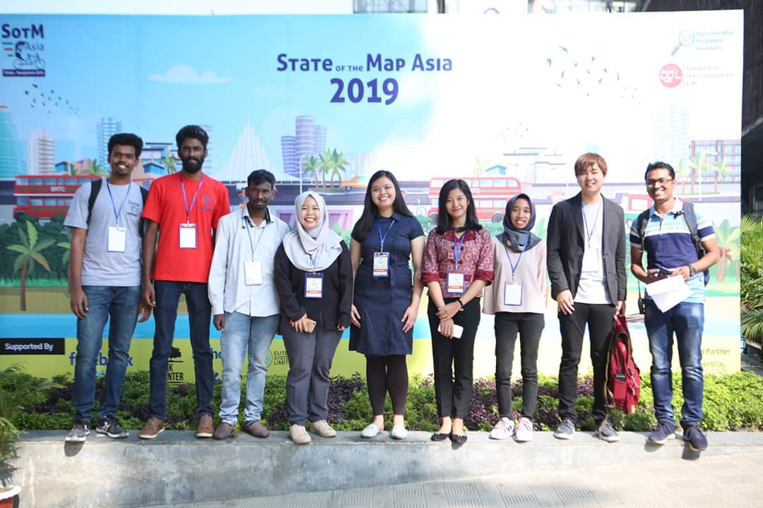
Beberapa peserta yang mendapat beasiswa

See full entry

Location: RW 07, Tebet Timur, Tebet, South Jakarta, Special Capital Region of Jakarta, Java, Indonesia

“Permission to trace from heatmap

Wednesday at 19:20

Hi 😃

I would love to improve OSM by tracing missing paths from your heatmap. Are you willing to permit this to OSM users?

Currently OSM is the best outdoor map in Sweden but unfortunately a lot of paths is still missing in my area. I would love to use your heatmap to help me trace and visit new paths and add them to the map.

I look forward to you response and hope that you will give back to the community by allowing this use of the wonderful heatmap.

Cheers pangoSE

Scarlett Today at 17:31

Hello,

Thanks for your interest in using Strava! If you’re interested to learn more about how Strava data is used for city planning, you can learn more through the Strava Metro site.

Hope that helps!

Regards, Scarlett Strava Support Team”


Any suggestions? They refer me to a service “Strava Metro” that is only available behind a paywall and do not offer a heatmap at all.

Ideas for questions to ask:

  1. You did not answer my question. Am I permitted to trace from your heatmap - yes or no? If you want attribution for allowing us to trace I would be happy to add Strava to our list of contributions: osm.wiki/Contributors
  2. Strava Metro access would be nice, would you be willing to provide that data for free to OSM users to trace after?

I was very excited since I first knew that I was one of the people who got the opportunity to attend the State of the Map Asia through a scholarship program. This year’s State of the Map Asia was held in Dhaka, Bangladesh on November 1-2, 2019. Then I rushed prepared the documents required so I can get my visa processed as soon as possible. Fortunately, there were other two scholars from my office, HOT Indonesia, They are Yeni Primasari and Tri Selasa so that we can prepare visa supporting documents and apply for the visa together.

See full entry

Location: RW 07, Tebet Timur, Tebet, South Jakarta, Special Capital Region of Jakarta, Java, Indonesia
Posted by pangoSE on 9 November 2019 in English.

JOSM is my favorite editor! It has so many functions and plugins that almost every task you can think of is covered (besides splitting multipolygons, but work has started to remedy that).

Today I learned how to add new nature reservations from a geojson layer by merging selections from it into my osm data layer.

  1. Select the new element in the json layer
  2. press ctrl+shift+m or edit->merge selection
  3. switch layers and edit the tags
  4. upload

Easy peasy!

Posted by pangoSE on 9 November 2019 in English. Last updated on 10 November 2019.

The latest stable release now support geoJSON

Hooray!

Why is this fantastic? Because it means that I can now avoid Shapefiles when exporting from open government data from QGIS and export to “geoJSON with newlines” instead.

//Edit I later found out that KML is better because the attributes of polygons was removed in the geoJSON export.

It all started out nice enough, the Knight Foundation paying for a team of professional developers at Mapbox to develop a new, user-friendly website editor to replace the ageing, Flash-based Potlatch. This brought us the iD editor which for roughly six years now has been the default editor we present to new users, and the user friendliness of this endeavour is certainly unparalleled in OSM.

To new users, this editor represents our project and our community. If this editor tells them that they should do something this way or that, they will assume that “OpenStreetMap wants me to do this”. The iD editor is the only editor endorsed by the OSM Foundation in this way, and with great power comes great responsibility.

A responsibility that the iD team is increasingly unable to shoulder.

There wasn’t much to complain during the early years except perhaps the lack of support for one thing or another, cases where everyone including the developers agreed that improvements need to be made. But now that the basic functionality is there, iD developers are starting to believe they have a mandate for more. Rather than just giving users a tool to contribute to OSM, they are directing users to contribute in certain, very specific ways - preferring one tag over another, using one channel of communication with the community instead of another, “upgrading” the work of other users according to rules set out by the editor developers alone, striking deals with commercial validation platforms, loading auxiliary data from Facebook without the user’s consent or any previous discussion, and so on.

See full entry

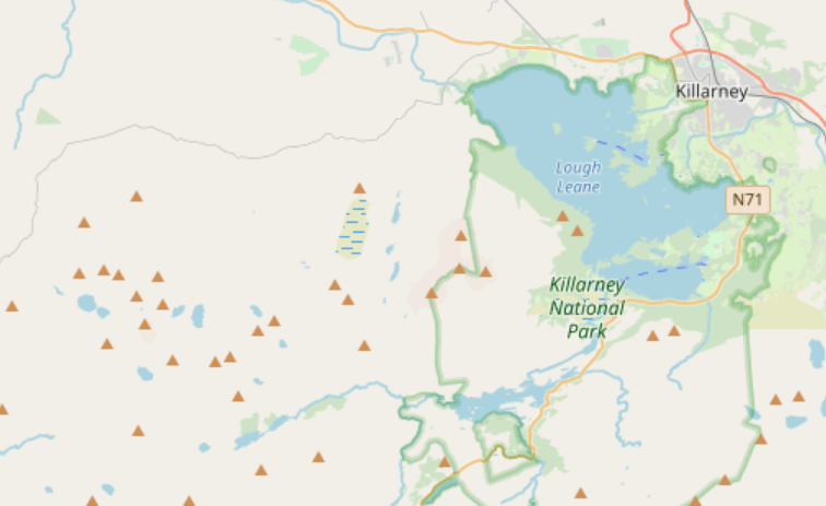
There are a lot of peaks mapped in OpenStreetMap, ranging from proper mountains to mere pimples. They’re usually rendered the same regardless of how high they are:

OSM Carto SW of Killarney

However, with a bit of preprocessing and a bit of help it’s possible to render higher ones at a higher zoom level:

See full entry

Location: Highland, Scotland, United Kingdom
Posted by pangoSE on 8 November 2019 in English.

You can help with the integration of OSM and Wikidata by using this tool: https://osm.wikidata.link

A while ago the property OSM relation id was added to Wikidata.

Since then a lot of objects now have an OSM id attached.

This enables us to harnes the power of Wikidata queries and do something with OSM object based on that.

Today I did this search https://query.wikidata.org/sparql?query=%23OSM%20relation%20ids%20of%20Swedish%20counties%0ASELECT%20%3Finstance_of%20%3Finstance_ofLabel%20%3FOSM_relation_ID%20WHERE%20%7B%0A%20%20SERVICE%20wikibase%3Alabel%20%7B%20bd%3AserviceParam%20wikibase%3Alanguage%20%22%5BAUTO_LANGUAGE%5D%2Cen%22.%20%7D%0A%20%20%0A%20%20OPTIONAL%20%7B%20%20%7D%0A%20%20%3Finstance_of%20wdt%3AP31%20wd%3AQ200547.%0A%20%20OPTIONAL%20%7B%20%3Finstance_of%20wdt%3AP402%20%3FOSM_relation_ID.%20%7D%0A%7D

It outputs the counties of Sweden and their OSM relation id.

I use this to easily get all the ids I need to generate the .poly files I need for my cleanup of water tags project. See osm.org/user/pangoSE/diary/391133

List of contries and OSM ids - a few are still missing

Total number of items in wikidata with OSM relation ids are as of this writing 101725 which is about a third of all relations with a wikidata key.

Background of the Challange:

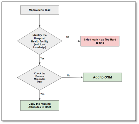
The challenge is to improve the health care information in India which can be beneficial for the people in need. In order to do so we need to re-position the coordinate with their actual ground truth position (If they are not at the actual position) with the help of local knowledge and add the Additional Tags from the MR Properties to the amenity.

Use Maproulette and Josm in order to add or modify hospital and all other sorts of health facilities records in OSM.

Instructions:

Alt text

See full entry

Posted by Neena2309 on 8 November 2019 in English.

My Intro

Am Sowmya Nayani also called by “Neena” and am a professional “Cartographer” from Hyderabad India. Am trying to Improve the Base Map of OSM in my location (India) you can support me by taking the Maproulette challenges.

Connecting Villages Project:

KamaReddy: https://maproulette.org/browse/challenges/8354 Srikakulam: https://maproulette.org/browse/challenges/8929

Improve POI Project:

*Bihar:https://maproulette.org/browse/challenges/8020 *Bangalore: https://maproulette.org/browse/challenges/8023

Thank You

On November 1-2, 2019, I attended the State of the Map Asia for the first time. This year’s State of the Map Asia was held in Dhaka, Bangladesh. I was able to attend because thankfully I was granted a partial scholarship.

Some of SotM Asia 2019 Scholars
Some of SotM Asia 2019 Scholars, (credits: twitter @SotmAsia )

See full entry

Location: RW 07, Tebet Timur, Tebet, South Jakarta, Special Capital Region of Jakarta, Java, Indonesia
Posted by pangoSE on 7 November 2019 in English.

Despite not having the same access to resources like laser scanning, aerial photos, etc. we beat LM here: https://www.hitta.se/kartan!~62.62401,17.94876,17.253034702482474z/tr!i=eBTVLIGj/search!st=cmp!q=bryggaren%20strand!b=53.95609:-9.49219,69.73333:25.00488!t=weblist?&search=bryggaren%20strand&sst=cmp&st=weblist (their road from NVDB is wrong, the church here is long sold and converted into a brewery and cafe.)

And here: https://www.hitta.se/kartan!~62.62882,17.94028,18.286908429940375z/tr!i=eBTVLIGj/search!st=cmp!q=bryggaren%20strand!b=53.95609:-9.49219,69.73333:25.00488!t=weblist?&search=bryggaren%20strand&sst=cmp&st=weblist (Their map does not indicate that you cannot turn left out on 719 from south. Also the bus stop is wrong, paths and a crossing are missing.

Could somebody please add the map on hitta.se to a compare map service?

Posted by kyjay on 6 November 2019 in English. Last updated on 29 November 2019.

Poorly-documented tags

department=*

The department of a university, organization, business, etc. that is responsible for, associated with, or relevant to the feature being mapped.

The wiki does have some mention of this tag, but it is woefully incomplete and ill-defined.

ex.

  • operator=Appalachian State University
  • operator:type=public
  • department=Department of Philosophy & Religion

Undocumented tags

scenic:name=*

The name of a way designated as a scenic way by some sort of authority, assuming this name is different from the usual/common/most signed name of it.

There’s one way using name:scenic=*, which is also not a documented tag, but scenic:name=* I feel makes more sense. scenic_name is also an option, but I think it’s better to use scenic:name=* as it makes the name be more obviously contingent on the scenic designation of the way.

ex.

  • scenic:name=New River Valley Byway
  • scenic:name=US 421 Scenic Byway

scenic:authority=*

The authority that designated this way as being notably scenic.

ex.

  • scenic:authority=NC Scenic Byways Program

Uncommon sources

source=NC Scenic Byways 4th Edition

The North Carolina Scenic Byways Program’s handbook. You can get it for free, it’s a public domain work of the state government that allows for you to add the byway into OpenStreetMap purely based on the (very clear) directions given for each byway. Can’t recommend it enough. Buy the book itself too if you can, the program needs the money.