Diary Entries in English

Recent diary entries

Posted by geoleighyers on 6 November 2019 in English. Last updated on 7 November 2019.

An awesome group of OpenStreetMap PH volunteers and drone enthusiasts visited Lupang Arenda in Taytay, Rizal to collect aerial and street-view imagery. With the help of Barangay Sta Ana officers, we were able to conduct the survey smoothly. I was part of the drone team and our goal was to provide high-resolution imagery for mapping buildings, roads and other attributes using OSM.

As my first urban aerial imagery collection experience, it was a trial by fire. I used to have that confidence with my skills but those unpredictable factors and unpreparedness made me question my skills as a drone pilot. It was challenging but at the end of two days, the images were collected, the high-resolution orthophoto, digital elevation models were produced and I learned to be prepared even in unpredictable times.

July 7 Fieldwork:

gras Team photos from @GOwin

See full entry

Location: 14.538, 121.109
Posted by Uyan on 5 November 2019 in English.

I started learning how to use JOSM today, and I quickly noticed some advantages over the online iD editor. The first would be the seamless editing. Since there’s no need to “stream” data, all the actions taken in the editor are slightly quicker. You also have the ability to tag multiple objects at once. I’ll continue to practise with JOSM on lower priority projects.

Posted by pangoSE on 5 November 2019 in English. Last updated on 14 November 2019.

I found a lot of lakes in Sweden which has natural=water but not tagged with any water= tags like water=lake. Most of them (est. 98%) are lakes.

I just wrote this https://josm.openstreetmap.de/ticket/18297#ticket

This resulted in one of my biggest changesets to date: osm.org/changeset/76657579

I have now found these tags missing on 3 continents Eurasia, Africa and South America.

Note: be careful with bays like this one as these are currently tagged with natural=water and no water tag because we have no suitable it seems. I add water=bay to these because they are not closed of like lagoons.

Note2: also be careful of riverbanks not tagged with waterway=riverbank.

Note3: My current workflow is this:

  1. download country or part of country (<100 mb) from geofabrik.
  2. use osmconvert and osmfilter to extract the natural=water and drop water= & waterway= tags. I use .poly files to extract smaller areas from the large country files. See osm.wiki/Osmconvert#Example_using_a_polygon_file_from_polygons.openstreetmap.fr for how to do that. An example command I use is: “osmconvert sweden-191107.osm.pbf -B=norrbottens-län.poly –complete-ways –complete-multipolygons -o=out.o5m && osmfilter out.o5m –keep=”natural=water” –drop=”water=” –drop=”amenity=” –drop=”waterway=” >out.osm”
  3. open the filtered .osm-file in JOSM
  4. inspect all elements to see if any are clearly reservoirs and add fixme tags to uncertain ones.
  5. search like this: “natural=water and -waterway=* and -water=* and -wetland=* and -sport=* and -landuse=* and -surface=* and -golf=* -fixme=* and (type:way or type:relation)” to filter out any strange water areas.
  6. add water=lake to the rest and source:lake=manual review based on MAXAR

Since departing Ashgabat, I have not collected much imagery, but anticipating that I will get back into it soon, I decided to invest in a dedicated smart phone just for that purpose–nothing fancy, just something with enough RAM not to crash and able to accommodate a large SD card for storing images. The Mapillary website advises that the requirement for the Mapillary app is Android 4.0 or higher, so I bought a gently used, relatively inexpensive older model Samsung smartphone with Android 4.3. However, Google Play informed me that my newly acquired phone is incompatible with the Mapillary app since it requires Android 6.0 or higher. Google Play refused to install it, so I now have an extra Android smartphone which is essentially useless for the purpose for which I bought it!

Yes, I have pinged Mapillary and asked that its website be updated.

Posted by Weatherman1228 on 2 November 2019 in English.

Well, some of you may have noticed that I like to add all of the little ponds and streams.That is all true, and I will tell you why. I am a person who loves weather (as told by my name) and maps. The way I see it, maps should be as detailed as possible for multiple reasons. One of them is to forecast the exact weather. If there is water nearby, there may be patchy fog right their if conditions meet. I also add that kind of stuff because I am very picky about things, and if I see something that is not their, I will add it. I also add intermittent lakes and streams that I am 100% sure that they exist during the wet season. I am a very knowledgeable person, and you may see more of my edits over time.

Location: LandLab, Escambia County, Florida, 32533, United States

OSMF board elections are taking place in December and this year there are four seats on the board to be filled so it will be a fairly significant event. Candidates for the board will be asked to nominate themselves in a few days.

Having observed the board elections during the past years with very different people putting themselves up for election and attempting to convince the OSMF members to vote for them using various strategies i thought i’d this year formulate some advise to potential candidates in advance based on my observations of the past years.

There are mainly two reasons for me doing this:

See full entry

Posted by Uyan on 1 November 2019 in English.

I reached intermediate mapper status on HOT Tasking Manager a few days ago. Now that I’m able to take on tougher projects and validate others’ work, I think now would be a good time to “start again”: learning how to use JOSM to map instead of the online iD Editor. I’ve only used the building label for 90+% of my edits so far but I can see lots of road labellings, as well as rivers and bridges, that I should learn about if I want to become a better mapper. So far I’ve been mapping for 1 hour a day almost daily for the past 2 months. Now I will be taking it slow for a few days while I get to grips with learning a new software.

Last month I gave a presentation at the North American Cartographic Information Society (NACIS) conference about getting Native Reservations to show up on OpenStreetMap.

I blogged about this previously: “It’s about time OpenStreetMap showed native lands on the map”. Now you can watch the video of my presentation on YouTube.

You can also follow along with the slides on SpeakerDeck.

Location: Downtown Tacoma, Tacoma, Pierce County, Washington, 98402, United States
Posted by mbeyerle on 31 October 2019 in English.

From what I can tell, OpenStreetMap lacks a tag allowing mappers to mark (yes, subjectively) roads that are unsafe for cyclists. In my opinion, this feature really ought to be added. It’s the last feature that’s needed for services like Komoot to actually become highly useful.

In State College, North Atherton Street is almost always too busy for cyclists; as such it’s generally avoided.

This has been discussed previously, but no official answer has arisen. It behooves OSM to come up with a fix to this problem.

What do you recommend with regard to adding this tag?

It is known all over the world that OpenStreetMap is a free source GEO based map service which gives access anyone to use its data for humanitarian work or something else, can be the key to implement a community .It is usually that now a days data is being one of the best object to make proper system, so why not in this platform.In the whole world all the community not getting all of digital advantage due to lack in communication system. OSM can be a communication system to communicate with them.

We who map in this platform and sometimes we do huge number of emergency map in any disaster or something else. It is the way to implement a community through mapping and I seem that in most of the map, all of community area not mapped with its valuable information which be helpful to local people or very little area has been under map.But we know remote area should be mapped to implement the community and OpenStreetMap is the one of the best source for implementing any of local community .

But you may hit a question that how is it possible ? Yes,it is possible cause there are lots of local mapper working here and contributing a lot.They are able to map on their own area remotely or field.By tracing from imagery we can find out all of important objectives like highways,buildings,water body, forest etc.

Highway and buildings are one of the most important element to map an area along with waters.

Happy Mapping..

Posted by joost schouppe on 29 October 2019 in English. Last updated on 5 November 2019.

December is election season in the OpenStreetMap Foundation. The Board is planning the next elections already, so now seems like a good time to talk about my first year as a member of the Board.

Why being involved in OSMF matters

OpenStreetMap is a project of many hands. All around the world, people are doing amazing stuff: mapping, building community, inventing new data uses, building tools. Yet most of the visible innovation is happening on the fringes, not the core of the project. That’s normal for a community like OpenStreetMap. For example, new mappers are much more likely to convince someone to start mapping then regular ones. If only because us hard-core mappers have been stalking our friends for ages already. You won’t be getting many new open source routing planning experts on board - they’ve already seen the light. It is the people who are “on the fringes of OSM” that have the best view of where we can grow further.

And yet, OpenStreetMap isn’t run by people from the fringes, but by core volunteers. While people all over the world are developing new “osm welcoming tools”, we haven’t even started talking about integrating such a tool into osm.org. While vector tiles are now the industry standard, we don’t even have a roadmap on how to get there. Time and again, we see people ringing alarm bells about the lack of progress in the core. I believe part of the reason why this is happening, is that from the inside out, all looks like it’s going swell.

See full entry

Recently at the Portuguese OpenStreetMap Telegram group we have been discussing the issue of the Pokémon Go! Players that become OSM contributors with bad intentions, by adding fake parks or wrongly to their ingame interest.

We decided to check how many parks existed in Portugal by using overpass turbo back in August (kudos to Luis Forte for the help). To our surprise there was over 7000 parks. We decided to create a map roulette mission to validate the parks. Some are indeed hard to validate by arm chair mapping, some are not. Up til now we have validated 20% of the parks on OSM and acknowledged that more than 12 percent were indeed badly tagged and only 7% were correctly tagged.

As example,gardens of private property or grass in roundabouts. https://maproulette.org/challenge/9053/task/24888572 https://maproulette.org/challenge/9053/task/24888572

See full entry

Location: Fajã Escura, Nuns Valley, Câmara de Lobos, Madeira, 9030-335, Portugal
Posted by InfosReseaux on 26 October 2019 in English. Last updated on 9 January 2020.

Power lines mapping has been a common practice for years and their supports can be used as landmarks in the country. There is undergoing work to improve the way we describe lines supports, including towers, not only for power but for telecom or other utilities as well. This diary will help to understand how is it going.

Currently, power functions find corresponding values in tower:type key. Main tower:type key use case is certainly to define the shape or the purpose of a tall and thin building.

As :type suffix may not be desirable since it doesn’t bring any extra information, I’m currently contributing as to cleanup this key in the power lines context and encourage the use of more meaningful terminology to make the same information more accessible, known as line attachments and management.

These concepts aren’t restricted to power towers and would have been redefined on other kind of power supports if nothing hadn’t been done in past months to cover the need to give more and more consistent information about infrastructure.

See full entry

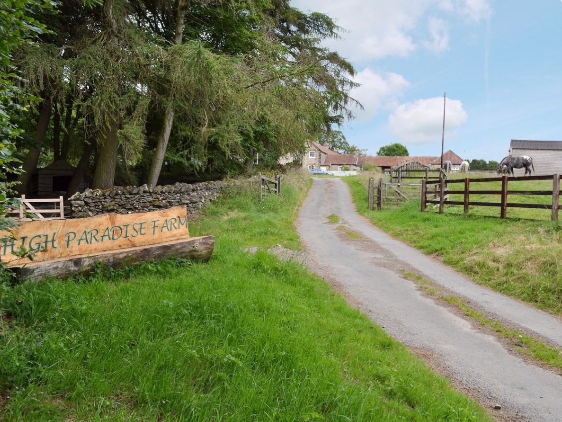
Service road into High Paradise Farm, Yorkshire

I was prompted to write this because of a few discussions over the last couple of months - people talking about the default tags on various OSM elements, reactions to Amazon mappers’ additions of “last mile” service roads and discussions about how to tag England and Wales’ public rights of way network.

This is very much a personal view and one that’s very “England and Wales” centric - there are lots of different approaches to rural tagging in general and footpath tagging in particular, and many places around the world (enlightened places like Scotland and Scandinavia) have different default access rights to the curious set we have ended up with in England and Wales.

Let’s start with an example - what’s the reasoning for the tags on this way in OSM?

See full entry

Location: Low Paradise Farm, Boltby, North Yorkshire, York and North Yorkshire, England, YO7 2HS, United Kingdom
Posted by Joseph E on 25 October 2019 in English.

Dear all,

Today, v4.24.0 of the OpenStreetMap Carto stylesheet (the default stylesheet on the OSM website) has been released. Once changes are deployed on the openstreetmap.org it will take couple of days before all tiles show the new rendering.

Changes include:

  • Create darker river-color for river & canal areas and waterway lines (#3930)

The color of river, canal, ditch and drain waterway lines and river and canal areas is changed to #8fcadd (Lch78,21,227)

  • Fix rendering of water body labels (#3919)

Restores rendering of water body labels on points (node features) Fixes rendering of natural=bay to use italic font at all z levels Cleans up duplicate natural=strait code in water.mss

  • Precedence of junctions over POIs (#3915)

Junction=yes, =motorway and man_made=bridge labels now render before amenity-points This prevents icons from blocking the display of these text labels

  • Remove rendering of waterway=wadi (#3931)

The tag waterway=wadi is deprecated, suggested replacement: waterway=river/stream + intermittent=yes OR natural=valley

  • Move parking to amenity-points layers, change way_pixels limit and initial zoom level (#3923)

Moved parking features back to amenity-points layers Changed parking text intial zoom to z14, as planned in PR #3612 Change way_pixels limit for parking icon (750) and text (3000)

  • Don’t use classes anymore (#3912)
  • Convert state & country layers to ST_PointOnSurface (#3920)
  • Convert addresses to use ST_PointOnSurface (#3898)
  • Apply bbox to part of “addresses” query (#3942)

The 4 changes above are needed to allow use of vector tiles ST_PointOnSurface is used to generate a point for labeling Classes are removed, replaced with the layer id

  • Documentation updates (#3911) & (#3910), Code clean-up (#3899) & (#3922)

Document inner line rendering, update docker documentation Clean-up text-placement / marker-placement, remove natural=marsh

See full entry

Location: Siepkosi, Jayawijaya, Highland Papua, Western New Guinea, Indonesia