Diary Entries in English

Recent diary entries

Posted by Uyan on 12 October 2019 in English.

Today I moved onto some higher priority projects. I saw other people’s styles of mapping and learnt some techniques for improving my own.

The first, and by quite a way the most important, technique was not to map trees or woodland. I thought it would be helpful to map woodland so that aerial emergency services would know where they can and can’t land. However it takes an extremely long time to map all the trees that weave their way through the landscapes of our earth. I suppose at the end of the day they would be able to see with their own eyes if they could land at the scenes of any incidents once they got there. Trees might have been cut down, as well, in the time between the satellite imagery being uploaded and the incidents.

The second, which is more a corollary of the first, is to use less nodes when mapping. It can save some time, but saves an especially long amount of time with regards to woodland; which I won’t be mapping as much from now on, as mentioned previously. Hence there is a good chance that I’ll keep mapping nodes with the same frequency as I used to. Of course there are many objects I have yet to map, rivers would be a notable example, so I’ll revisit this rule of thumb when the time arises.

Posted by naveenpf on 11 October 2019 in English.

This was my first SOTM conference. Thanks, OSMF which selected me for a full scholarship.

Visa was process was simple. Since it was well documented by Dorothea(Thank you so much for all the support). I had my flight from Bangalore in 19th early morning. I have reached on 19th noon in the guest house.

HOT Summit

That afternoon and the next day I could attend HOT Summit. On Thursday, I could attend Youthmapper talk, HOT Voting member’s forum. On Friday morning, I attended a talk from Mikel, talk on HDX, healthsites and Inaware. On Friday afternoon, I could attend Impact initiatives,letsgirlsmap talk, Mapping Indigenous Communities talk etc.

I had met many staffs from HOT to tell thank you for the help they have done for India disaster response mapping. Russel, Geoffery Jeesica, Rebecca, Ramya and Tyler. From HOT Board, I could meet and had a small chat with Trudy Hope. I am happy that people like Hope is there in the board. Ramya helped me to get stats required for my presentation. Thank you Ramya.
I had also chance to meet Youthmappers team. I met Patricia and Marcela to understand how youthmappers works.

Key takeaway from HOT Summit is that

  1. In India, we need to start a few youthmappers chapters.
  2. From India community, we need few people HOT working groups.

State of the Map 2019

See full entry

Location: Madathikara, Mukundapuram, Thrissur, Kerala, 680100, India
Posted by Sawan Shariar on 8 October 2019 in English. Last updated on 18 November 2019.

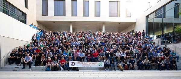
The State of the Map 2019 event happened on September 21-23, 2019. This year SotM 2019 was held in partnership with the Institute of Geography of Heidelberg University in Germany. The event was themed on Bridging the Map, people coming from different regions who in one way or another used OpenStreetMap in their works or fields shared their knowledge, expertise and experience at the Neuenheimer Feld campus.

Alt text

See full entry

Posted by tshedy on 8 October 2019 in English. Last updated on 9 October 2019.

Earlier this year I applied for the scholarship to attend HOTSUMMIT and State of the Map (SOTM) global Conference in Heidelberg, Germany. The application was accepted and I got fully a funded scholarship. It was the first SOTM conference that I was able to attend and I was looking forward to meet other OSM mappers and data users and have a clear picture of the experiences shared.

OSM Foundation Assistance

In preparation for the conference I received an email from Christine Karch asking whether I would be interested in joining and working together with the program’s committee, and of course I accepted. Being part of that team gave me an insight of how preparations for such a huge conference are done, as well as the criteria used on how the choice of proposals submitted is done. That task was a good experience and I was grateful.

I would also like to show my appreciation to Dorothea for here support and guidance from the day I got accepted for scholarship. She was always available through emails and ready to respond to all the questions I had. The process of getting visa was successful first hand because of her help in listing all that’s needed and sending all the documents I would need. She also made my travel to Heidelberg stress-free from flights connections, train and public transport connections.

I also like to thank Christine ones again for believing in me and giving me an opportunity to chair nine sessions at the conference. I was grateful that I was given that chance because in my experience such little opportunities help in building one’s confidence in public speaking.

Conference Presentations

See full entry

Posted by Tomas Straupis on 5 October 2019 in English.

Labels should intuitively “connect” to their respective object on a map so that map reader could “feel” the stronger connection between the label and waterbody (lake natural=water or reservoir landuse=reservoir). When calculating places for labels in multi-scale (or vario-scale) map, we can distinguish three types of label placement:

  1. Multiple large labels - this is used in large scales where waterbody is so large that a very large label could fit. Usually at that point waterbody is so large that only part of it will be visible to map reader. This means multiple labels could(should?) be placed, trying to calculate the average size of a map view - we would like one and only one label to be visible at one point and as label positions have to be calculated beforehand it is impossible to make precise calculations as maps would be viewed on different devices with different size of map canvas. (There is also an interesting question if such labels should be horizontal or not, if not - how should they be positioned?)
  2. Curved labels - middle scale labels where label can be curved according to the geometry of a waterbody.
  3. Simple labels - small scale labels, where it is no longer possible to have curved labels (as they no longer fit into waterbody) and only simple straight line labels are possible.

Note that type of label depends on a particular scale+waterbody. That is on one scale you could have some waterbodies with large labels, some with curved and some with simple labels. As can be seen here:

See full entry

Lately, I’ve been sitting with emptiness, constantly battling with my depression and anxiety, yet fighting to exist in my everyday life. I feel like my pursuit for finding meaning and purpose in life that transcends change never ends. And as I live my life, I tend to look for something positive hoping to fill that void. Well, I guess this is what #existentialcrisis does to me.

Luckily, I got a partial support to attend SoTM and HOT Summit in Heidelberg, Germany. Of course, I do not want to miss this great opportunity. I haven’t attended a global SoTM conference before, and this news gives me another hope in life or at least something to look forward to. And maybe, just maybe, this is the ‘something’ I’ve been looking and waiting for. The ‘something’ that can numb the perpetual feeling of emptiness.

And since I only applied for partial support from SoTM (only the accommodation fees and conference tickets were covered), I need to ask my employer to cover the remaining travel expenses I have. Unfortunately, I was informed that there are no available international travel funds for non-contractuals like me. Sucks, right? The fact that UP couldn’t support me keeps me up at night and eats at my soul again. But I do not want to give this opportunity up. No, not yet. And so I took my chances and talked to some people in the OSM Philippines community about my dilemma. Although they also couldn’t provide financial assistance for me, I am still grateful as they have shown overflowing moral support to me, especially when they learned I got nominated for the OSM Awards 2019.

I don’t want to give this up, as I have been eyeing to attend global SoTM since 2015. I was left with nothing but to support myself financially in this journey. I realized that nothing really comes easy, and so I need to take risks, even if it costs me a lot.

See full entry

Posted by matthewsheffield on 4 October 2019 in English.

I think I’ve mapped all the highways and residential areas in the Aileu district of East Timor. It took about five weeks all told. It’s a neighbouring country, and one that Australia has tried to deliberately fuck over (the Witness K debacle still isn’t settled), so I wanted to improve their maps. There’s a coffee business, Wild Timor Coffee that’s linked to that area, run by Australian for the co-benefit of the Timorese, so that’s another link to the place.

Anyhow, I hope it helps trade, health, tourism, and encourages locals to improve the map themselves now there’s more there to go with….

Location: Fahisoi, Liquidoe, Lequidoe, Aileu, East Timor
Posted by BA-Zone59 on 3 October 2019 in English.

Hello Everyone! Good Day! Im John Christian E. Subido a BSA1-1 Student from Pup San Juan Campus, Here We have done 4 sessions of Mapping in CWTS and the First Session was a very clever day that time because it was my first time to learn about this mapping and it was a very interesting journey due to I like and love technology and at the same time learning on how ti map. Then I can say that spending time here is productive I enjoy every moment and as spending time and my day here instead of sleeping is worth it. I think it is relevant for us students not just a BSA student but being student because in the future as a Citizen working in establishments and entering Job industries I think having Expirience mapping help us a lot and gave us more and deeper knowledge to undestand the roads and the map. And now last session my Favorite Activity is that Doing my own account in mapphilary hahahahah! because for me its a way of owning a account ang having those scores and competing to others haha its so much fun and yes! I do have fun and enjoy mapping :) then Lastly I would like just to say that the teachings and the facilitators are doing such great and you know what? Doing this mapping is that I didnt Felt the difficulties why? because the facilitators and the professor are kind, have a lot of patience and they dont even put preasure that can knock your butt off instead they make you feel that you can do it and it was a nice way to learn because for me it is easier to learn when teachers never put on preassure on you and motivates you that you can do it and you can catch up to others.. So as this is my or our last day Its a GoodBye!!! :) I cant say any improvements because I think everyting is great and runs smoothly and I just wanted to say that Im very Thankful to have this opportunity and its been a great great journey to learn! 10/03/2019 :)

Posted by Beanene on 3 October 2019 in English.

To whomever may read this,

I’m Bea Gabrielle A. Aranilla. 18 years old. Currently residing at Taguig city. I learned a lot in the four sessions of mapping. I managed to map schools as well as other areas and verify pedestrian lines, etc.It was fun actually. I really think it has big relevance towards the world today. I really think Open Street Map is a big help to many people for it provides more detailed information about directions and places a person wants to go to. Knowing how to edit and map out places is a big help to society already especially towards bloggers, travellers and etc.

One of my favourite activities is the time when we have to map and put out roads, paths, etc. I was even given a “recognition” for having lots of points. There was no prize though but I am glad for I finally know how to edit and map. I think I am going to volunteer to help and for further development.

The people assessing the sessions were great. They really taught us well. I learned a lot from them. Mingawon ko nila except sa usa. Hahahaha!

Posted by Jubs2137 on 3 October 2019 in English.

Hello! My name is Francis Ann! I am an Accountancy student in PUP San Juan but I am actually from the Leyte Province. Specifically in Tacloban City! :D My time with the CWTS Mapping was an amazing experience! At first, I was a bit skeptical on what Mapping is and what we were going to do. Before we even tried to attend the first session, we weren’t really oriented on what it is and what to do. However, the first session was great! As expected, we were first oriented on the Basics of Mapping! It was a really fun experience and it was beyond my expectations! It was difficult at first but eventually I got the hang of it. I’m looking forward to volunteering and doing this in my free time. It’s a great contribution to the community especially to the government and non-governmental organizations in times when there is a calamity on places that are not really known. I will definitely recommend this to my family and friends! It is definitely a great help to locate, track and figure out places that are not really know and it can be a basis for organizations to locate places affected by natural disasters to contribute to the community. Like for example, the Supertyphoon Haiyan. My family and I were all lucky to survive the horrible disaster. It made me open my eyes and heart to help those people who are in need because I feel sympathy for them cause I also experienced what they experienced. As an environmentalist on my little ways, I often volunteer to help those people who were deeply affected by typhoons and disasters. Whether it be travelling with other volunteers or contributing money and goods to those affected people. Mapping can be a great help for me and other organizations to help these affected people! Looking forward to doing this and sharing this to all of the people to raise awareness and to help contribute to the community and the society! :)

Posted by MorganStark on 3 October 2019 in English.

I am a BSA Freshmen, the 4-session of the mapping was so amazing. It is a combination of fun and knowledge. I have learned so much these past few weeks of attending this program. It is good that we can actually help , even for a small thing, to the community even if we’re still a student. My time that was consume here in this program is not a waste but done a very productive and informative time for myself. I had so much fun!!! My fave part is that we are very competitive that even if it is not “mapping time” and we’re just having our break, my colleagues are doing something related to the program. It is truly fun because every time it’s mapping time and we’re busy doing our own things na hindi na namin napapansin yung oras kasi sobrang focus sa mga ginagawa eh, nalalaman nalang namin kasi pinapaalalahan HAHAHA! This program helps me relax a bit from a very “stressful” course i’m taking up. I hope i could do these things again in the future. Thank you for the great experience, OSM! Keep up the good work. Thank you gentlemen for the guidance and patience you have given us. God bless us all. <3 :”>

Posted by Gwy on 3 October 2019 in English.

I am a BSA 1-1 student of PUP SANJUAN. I really like stuff related to computer that is why i do really think that the CWTS #MapaTime sessions were very productive. I learned a lot of things fropm this and I think the best are the cooperation and unity. In the activity, there is a time that we have to fix or identify some roads and things on a certain region. And ang laki ng tinuro noon sakin kasi naparealize nito kung gaano kagaling ang pagkakaroon ng kasama sa mga activities like this at sa dulo ay natapos namin ang buong rehiyon na iyon na siya naman talagang makatutulong sa ating mga mamamayang Pilipino. Overall sobrang saya ng ganito , sinamahan pa ng mga mbabait at pasensyosong mga nagtuturo kahit na minsan oaulit-ulit na yung mga tanong namin. Ang sakin lang sana magopen din siya for second years kasi gusto ko rin mabigyan ng opportunity yung mga kakilala ko doon na maenjoy ito haha. Tapos sana pwede ulit kami magkaroon ng ganito yearly ganon hahaha char. THANK YOU SO MUCH PO!

Posted by mzdce21 on 3 October 2019 in English.

I am bsa student at PUP SJ .It is really productive because this program is full of fun, experiences and memories. This OSM activity for 4 weeks helps me to gained more knowledge about mapping roads, lines, buildings and schools. My most favorite in this program is when we locate schools, indeed that it is not easy but when you found a real school you will feel “AWWW basic” hahaha. I love to volunteer and teach others to map and locate something and also it will help me to gain more knowledge that someday I can share it with others. Maybe the internet connection is badly needed to improve. I am satify in this program, I think there is anything to make like, having more programs and giving certificate that students or participants can have to their resume. Overall, this programs and activities make me improve and be competitive in every task that we will do. Also, I a glad to meet Sir, Osm haha at the kuya’s to lead me and help me in everything that i don’t know.

Posted by chxrlghkn on 3 October 2019 in English.

hi! I’m Marionne De Jesus and i was in the program of CWTS Mapping here in PUP San Juan Campus. I Like travelling so these activities is very helpful for someone like me. Also, I know that this is not only for our subject but it is also great to know that we are helping the authorities by mapping schools, roads etc. These sessions are productive for me because instead of just hanging around the campus, I get to learn learn new things and skills. because of that, I’m most likely going to volunteer to the next activities that they will organize. We like mapping schools, roads, and especially using the mapilliary app. It is like a game but it has a good cause. i know it will help me as a person who is interested in going some places out of town and it will be easier for me to locate places using the Open Street Map. :)

I am Mariesan B. Baris 18 yrs. old and I am a BSA student at Polytechnic University of the Philippines. My 4-week experience in mapping was pretty awesome coz I learned a lot of things that I never expecting to learn before since my course seems not align to this kind of thing tho I am grateful to help and contributed in Mapping. I would say that our 4 sessions in CWTS #MapaTime are productive coz like what I said I learned a lot of things and our prof and the students who help him are very approachable they are willing to help us when we don’t follow the instructions and we have a questions they are there to guide us. My favorite activities is when we are mapping the schools coz some are pretty difficult to find tho I enjoy the entire the sessions.