 OpenStreetMap

This might be handy to anyone who gets a waynes camera as a mounting idea.
Diary Entries in English
Recent diary entries
Here is a post I made about making a 360 rig for use with Mapillary
Ok! I’m on board, let’s use some data for OSM!! Wooo Yeah!!! Where’s the data?…
I spent a little over a year trying to get access to data, once I decided that was what I wanted to do. I now have permission from the local county where I live, some other county’s and some state data. And WoW! We now have more data to work with than we have time and mappers to processes it. It’s a good problem to have. So how did this happen?
This was my struggle and why it was worth it.
In this blog I will talk about what data we are using, how we are processing the data, then importing it into OSM. Some things are not considered imports at all since they’re more of a stare and compare, but I will cover them as well since we are using data others collected and have made available to us for use in OSM. Even analyzing data that is already in OSM to improve data quality. All that and more! :-)
First off, I understand many people do not like using others’ data for OSM for a couple of different reasons.
-
The data could be low quality. I once talked to a mapper when I saw that they removed an imported move theater from the middle of a corn field, due to someone blind importing. …Ouch!
-
Imports require a lot of technical knowledge of OSM and that excludes a lot of mappers.
-
Making sure the data is not copyrighted in a way that prevents it from being used in OSM. (I’ll touch on that in another post) There might be more, but these are the ones that I have heard so far.
In this blog I hope to address these concerns by demonstrating how we can set things up in a community-oriented way that streamlines the process and also keeps quality high. We have so many tools to at our disposal that I keep stumbling across them and finding new ways to use them for different projects! I hope to gain working knowledge and demonstrate how they can all work.
Also, I will be talking about how I got access to data for our local area and tips on how you might be able to do the same. That can be half the battle!

Over the last couple of years, the Cullowhee valley region has changed drastically. The university is growing and expanding and changing each year. Within the next 2-3 years, two of the older dormitories on campus will be going offline in preparation for new residence halls. Hopefully, if they are completed while I am still attending the university, I plan to outline a lot of the details of the additions. If anyone is familiar with the area, I plan to start cataloging in the very near future fire hydrants, FDC’s, and water points all across the valley for local emergency personnel to hopefully view the data we collect.
Does anyone have any groups forming in the area for OSM? Or perhaps, does anyone have any advise in how to efficiently collect and record this data to put into OSM?
Thanks, Ivan
After a lot of breaks in between and a few months, I’ve finally finished mapping Emerson! It took quite some time, but it’s finally done. At first, I was working pretty slow, but I started making more progress towards the end of April.
Something I found pretty interesting about Emerson is the small amount of businesses there. I might go add names to all the businesses in Emerson because there’s such a small amount of them.
Anyway, the next place I’ll map is Teaneck. It’s quite large in area compared to many other places in Bergen County, and has the second highest population.
Click below to see Emerson!

Gosh, the spammers are going for it at the moment on the OSM diaries. :-(
Thank you to everyone who’s handling the deleting of it!
Unfortunately, my feed reader sucks all the bogus entries in before they’re deleted, so I’ve got hundreds of Chinese spam posts (marked as Bengali for some reason), drowning out the interesting stuff. I’d switch to just the English feed, but am getting things via https://blogs.openstreetmap.org/atom.xml so there’s no option for that, and I don’t want to miss the other syndicated blog posts.
Maybe I should just head outside with a GPS… :-)
Posted by PeanutButterRemedy on 30 April 2019 in English.
Last updated on 1 May 2019.

Background
There exists at least one company out there that sells a service of boosting client company’s ranking in Google search results. One of the tactics they employ to accomplish this is putting the company name and website in as many places as they can. One of those places is a node on OpenStreetMap. It should be pointed out that there is nothing inherently wrong about adding this information to OSM. In fact, it is encouraged. However, the methods by which this particular company accomplishes this go against many of the best practices and guidelines that the community has set forth. This has caused much frustration in the community having to chase down their edits and correct them. Many attempts have been made to contact this company to work with them to correct their behavior, but they have all fallen on deaf ears.
Bad Behavior
Some of the actions the SEO has engaged in include the following:
- Creating throw-away OSM accounts for every single edit they make
- Registering accounts with email addresses that are ignored
- Using email addresses that purposefully hide the organization that created the accounts
- Spoofing or masking their IP addresses
These are all tactics they are using to avoid user and IP level blocks so that they can continue to pump bad data into OSM without being blocked.
Bad Data
A sampling of their additions shows the following type of problems:
- Street addresses that are abbreviated (
Rdvs.Road,Stvs.Street) - Unit/Suite information improperly added to
addr:street - Freeform text in the
opening_hourstag - Upper case characters in key names (
Telephonevs.phone) - Made up tags instead of proper feature tags (
category=Southwest Furniturevs.shop=furniture) - Lazy errors (
amenity=place_of_worshipfor a fish restaurant)

A hamlet in OpenStreetMap is, according to the wiki, “A smaller rural community, typically with fewer than 100-200 inhabitants, and little infrastructure.”. It is smaller than a village but larger than an isolated_dwelling. So, basically, it’s a very small rural town.
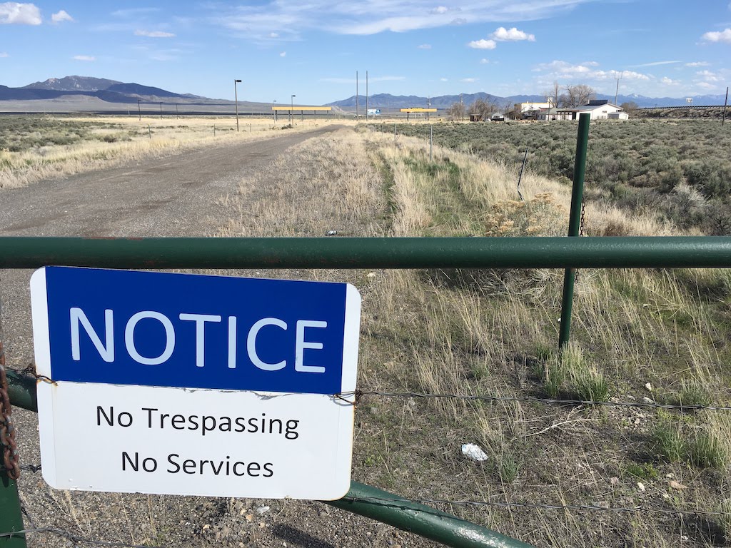
Oasis, Nevada. A hamlet in OSM.
According to OpenStreetMap, there are around 750 hamlets in Utah. I know we have a lot of small rural towns but I am not buying that it’s that many. Let’s have a look.
It turns out that all but 20 of the Utah ‘hamlets’ are the result of a poorly documented 2008 import of GNIS points. (There may be more changesets related to this import.) 500 of them have not been touched at all by human mappers since then.

I am Ezugwu, Victor Chukwuma. victorchukwumaezugwu@gmail.com,
I am a Nigerian and graduate of the University of Nigeria Nsukka where I read Geoinformatics and Surveying. The pioneer team leader Lionmappersteam Enugu Campus of the University of Nigeria (https://mobile.facebook.com/Lionmappersteam-enugu-Campus-361221567667528/?refid=46&xts%5B0%5D=12.%7B%22unit_id_click_type%22%3A%22graph_search_results_item_tapped%22%2C%22click_type%22%3A%22result%22%2C%22module_id%22%3A1%2C%22result_id%22%3A361221567667528%2C%22session_id%22%3A%22d0eabd601c2d9d12daa467ce69f0e8bc%22%2C%22module_role%22%3A%22ENTITY_PAGES%22%2C%22unit_id%22%3A%22browse_rl%3A11c8e1d6-a435-18b1-4414-6b29b6a91838%22%2C%22browse_result_type%22%3A%22browse_type_page%22%2C%22unit_id_result_id%22%3A361221567667528%2C%22module_result_position%22%3A0%7D).
I became a member of the OSM community in 2016. I was introduced to HOT and it’s activities the same year.
HOT is an international non govermental and humanitarian organization dedicated to reaching and assisting everyone in the globe despite their location through mapping and humanitarian activities. HOT ensures openness, transparency and discipline in carrying out it’s activities
HOT is also committed to making impact locally through local mapping of various communities by it’s members and as well as reaching out to places with disasters such as floods by creating tasks which the members of the community can map and such mapping sessions are well validated.
I appreciate the HOT management for the opportunity to be nominated as a voting member. I hope to grow the activities of HOT/OSM in my country and beyond if elected a voting member and as well participate more effectively in HOT activities.
Thanks to Pete Masters and HOT and it’s management for this opportunity to be nominated as a voting.
My name is Victory Chukwuka, I was introduced to uniquemappersteam by my lecturerer Mr Victor Sunday and was grew up interest in joining the team, today 30th of April 2019, i did my 1st mapping and it was really interesting coupled with the fact i have to see the exact shape and structures of building of my house in Lagos and some important places i use to know it was all fun mapping them. definitely i ll have to come back soon to do more of the mapping and experience fun and also learn too, so friends i encourage you to join this team #uniquemappersteam.
Ye, pretty much nothing here, but hey… you did look!
Map quest this
.JPG)
Here is a OverPass query for finding hotels and similar establishments claiming that they have internet access. According to internet_access it should not really be tagged, although the same wiki mentions option of using “internet_access:fee=customers”.
( tourism~/(hotel|motel|chalet|guest_house|hostel|apartment|resort)/ ) && ( internet_access:fee=* || internet_access=* ) && internet_access:fee!=customers

A rather interesting if eclectic collection of 45 interesting maps posted at https://www.farandwide.com/s/amazing-world-maps-74d6186e6d0e414b caught my eye. Here are some of the maps that caused me to stop and think.
Hei, started bringing to life the villages around the Munti Macini area in Romania, between Tulcea and Braila towns; most of them are just lines of roads (sometimes badly placed out of where they really are) and very few, if any, detail of houses even less of POI or important ones.
As of today I completed the houses/buildings of Nifon, Hamcearca, Caprioara, Greci, Balabancea, Revarsarea, Floresti, Tichilesti but if someone wants to join me in this effort, there is plenty more to do, especially marking important things such as hospitals, pharmacies, gas stations, bus hubs, food stores, completing mapping of building in the remaining villages (Macini, Jijila, Vacareni, Luncavita, Rachelu, Isaccea, Niculitel, Mircea Voda, Cerna, Traian, Turcoaia, Carcaliu, Garvan)…
Munti Macini are small but pretty, rising from the planes around them offer easy but good hiking, biking and excellent views.
Thanks
UPDATES: 2 May: finished Luncavita / 3 May: finished Rachelu / 16 May: finished Carcaliu / 23 May finished Cerna / 28 May: finished Macin / 11 June: finished Jijila / 13 June finished Mircea Voda and General Praporgescu / 19 June finished Vacareni /

On 26th April, 2019 we held a meeting in the school lecture theater. I the Coordinator of OyoMapperTeam Mrs Mary L. Marcellinus lecture the new intended members what OSM, YouthMappers and HOT is all about. The meeting was with postgraduate students in which in attendant, a Naval officer was in attendance and that they need to contributes to humanity…
Posted by Christine Karch on 26 April 2019 in English.

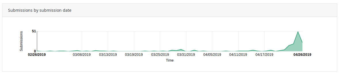
At the end there are 153 submissions. Thank you to everybody who submitted a contribution! And thank you for the suspense submitting within the last 24 hours ….
Posted by jinalfoflia on 26 April 2019 in English.
Last updated on 14 June 2019.

Grab is excited to share with the community, that our maps team in Thailand has been uploading street-level imagery in Mapillary for Chiang Mai City areas and we are now hitting ~82% which is approximately 1,667 kilometres of roads. We are expected to complete the 100% upload by the end of this month.💥 Update: We have completed 100% upload of the street-level-imagery in this region.

We also have uploaded imagery on OpenStreetCam for the Singapore area. ((edited-29th April 2019) This upload was done sometime last year)
Here’s how you can start mapping using Mapillary imagery, here are the detailed steps involved if you are using iD editor or JOSM for mapping. Want to start contributing imagery in your region, here’s how you can do it!
Happy Mapping!