 OpenStreetMap

I wonder why I spent so much time in and out on US Visa application when I can invest such time helping out my brothers in Philippines being ravaged by disastrous Typhon!!! Just occurred to me I can leave the Visa system for a while to cool off while I contribute to task #5236.And it was a great idea coz I just mapped a number of buildings.Let’s keep mapping using every slight opportunity on net!!!!#uniquemappersteam Now I can check back on the US visa application system to continue!!!
Diary Entries in English
Recent diary entries

After finishing mapping a lot of Paramus, I decided to map Alpine. While I didn’t really consistently map Alpine and instead mapped a lot of other random areas in Bergen County during this time period, today I decided to seriously revisit Alpine and finished mapping it.
It was way easier than Paramus, mostly because there is a lower population density and a lower area, hence less building to map. However, as Alpine is one of (if not the most) expensive places to live in within the entire United States, every building required way more nodes than usual to place them on the map.
A lot of my edits outside Alpine were in Hackensack. Downtown Hackensack has a lot of buildings and a lot of parking spaces. I’m going to map Hackensack very soon.
Next up is going to be River Edge, and then Palisades Park. I really love Palisades Park and every time I go there I feel great. Meanwhile, River Edge has a great public library, and something just makes Kinderkamack Road very lovable.
On OSM, Bergen County is improving quickly. At this rate, I don’t see much, if anything stopping me from going on for at least another month.
You can click below to see Alpine:

Development Seed data team has been supporting the HOT community for a long time collaborating in many mapping projects in response to disasters, health, transportation.
The main objective on the participation in these disaster projects in these cities is to mitigate and reduce the impacts of natural disasters, thus helping the population to save lives and reduce the victims of events.
In the last months, Development Seed data team have been working in Ebola 2018 campaign, in this campaign 58 projects were created on tasking manager that have been developing since May, the Development Seed data team supported a project in the Congo, other projects where our team helped were in the project of the eruption of a volcano in Guatemala, earthquake in the city of Takatsuki in Japan, and also in floods in the cities of Kurashiki and Sojya - Japan.
More detail about each project and our support in each one can be seen below:
- Ebola virus disease in Democratic Republic of the Congo
### - Project 2018 Ebola #49, Lac Tumba south 2
On 2018 May 8th, the Ministry of Health has announced the 9th Ebola outbreak in the Democratic Republic of the Congo. This task was aims to map the buildings in the villages south of Lac Tumba, in Equateur province.
The purpose of this mapping is to track all buildings that exist in the area to be able to visualize the population that exists in the area, which could be affected by Ebola disease if the spread of the disease is not prevented.
Task Manager for Project 2018 Ebola: https://tasks.hotosm.org/project/4632

Today I arose at 0400 hours to catch an early flight to Turkmenbashy, then upon arrival there rode a bus for three hours to Garabogaz over the bumpy P-18 “highway” (actually a 1-1/2 lane country road most of the way) to witness the opening of the Garabogaz Carbamide (Urea) Plant. This will be an important augmentation of the export potential of Turkmenistan so is something that needs to be mapped, including contact information, which I added this evening upon return to Ashgabat. A small number of Mapillary images are being uploaded as I type this.
Recently had a delightful narrowboat cruise around the Milton Keynes area (yes the canal route is remarkably green here). When I checked mapping, I found that, a few years ago, much of the towpath had been mapped as ‘bridleway’. Now, canal users did originally use horses to tow their boats but that does not imply any general right of access, unless a towpath has been adopted as a PROW. Most of the UK Canal Network is now controlled by the Canal and River Trust and there are signs to say that pedestrians may use the towpath, while cyclists are ‘permissive’ and horse-riders should seek permission. I assume this applies to all their canals, see https://canalrivertrust.org.uk/enjoy-the-waterways/cycling/cycling-faqs . I would support towpaths being mapped as bicycle = permissive (or yes); foot = yes; highway= footway; operator = Canal and River Trust; towpath = yes - and only designation= if a PROW. Where cycle networks run on towpaths then I’ve seen the use of highway=cycleway etc. Any other views? Maybe osm.wiki/United_Kingdom_waterways needs updating to reflect the available Canal and River Trust policies?

A new release is ready for download! Several new features and changes were made. For example the isochrone module is now open source! Read more about this release here
One of my favourite activities is mapping trails and other stuff in the forest, especially when mapping using an MTB. Using a bike allows my to get further quicker than I would by foot, and with the bike I can go more or less anywhere.
Also, it is really fun to ride an MTB in the forests where I live. I try to map the trails that might be useful for others. Another important thing is that other map providers often do not have any information about trails/paths in the countryside.
So I thought it could be interesting to show what stuff I usually pack when going on a trip. Apart from what is shown in the images I also bring some food or snack, such as fruit or a chocolate bar. Then I also keep some backup carbs such as a gel in my pack, just in case I run out of fuel.
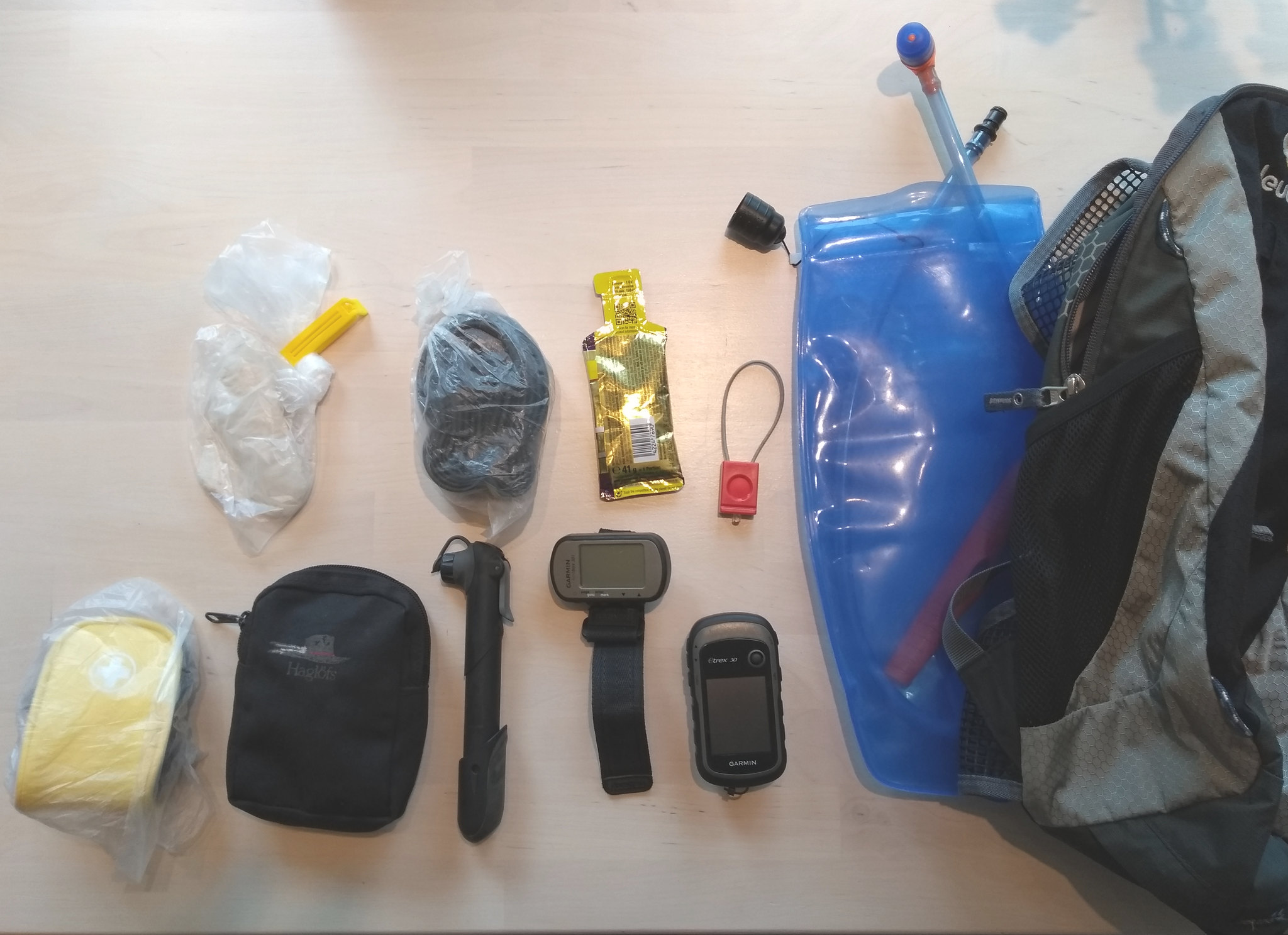 From right to left we have:
So today the 16th day of September 2018, I mapped the Cagayan and Batanes areas of Philippines. I contributed in mapping more than 80 buildings to support the local mappers and also to celebrate my friend’s birthday lol. Though I’m still mapping, lemme see how many more buildings I can help in mapping in the next few hours. Currently mapping this area
Posted by Inneh Precious on 15 September 2018 in English.

On Monday 10th September 2018 I was engaged into a week OSM fight with OLODIA AMBROSE a great colleague and friend of mine. I was able to meet the target of digitizing over 3000 buildings on Friday 19th of September 2018. My major contribution on the mapping were at #Mpapetremor, #Ozuoba_RiversState and others. Well, I had to give in a lot ; my time, leisure and duties for it tenaciously because my competitor is a tough match. One of my secrete to this huge success was performing my best under fun. Fun is the secret ingredient to staying calm and doing best when the heat of competition is turned up high. I tell you this is one interesting thing or game I find doing aside playing chess and I’m glad to be a participant. Above all things glory God.

Contributed to HOT OSM Project: #5236 - Typhoon Ompong: Cagayan and Batanes Structures
There were a lot of remote structures that made me imagine what horrors could have happened there and no one ever found out about. Though, on the bright side, they could also be secret headquarters of super-heroes.
In the end, I realized that the popular saying “Everything is connected” is not true

I participate in the PUPCWTS++ initiative as a mentor for volunteers undertaking their National Service Training Program, collaborating with a the San Juan campus of the Polytechnic University of the Philippines.
One of our program objectives is to provide the participants with a better appreciation for spatial data, and the same time, provide them with digital mapping skills, by contributing to other open data projects. We also would like to impart the value of volunteerism in them, and what it takes to become (digital) humanitarians.
Back in June, before we started, this is how the Philippines looked like with ImproveOSM:

Posted by elizabethsanner on 11 September 2018 in English.
So I am fairly new to OSM and am hoping that this will be a great resource for my masters thesis which is focusing on changing indigenous territorial boundaries in Mato Grosso do Sul as a result of the past 2 (well 3 I guess since Temer replaced Rousseff after she was impeached..) I have some shapefiles for boundaries from 2010, but nothing more recent. I’m hoping that this is a good place to look for up-to-date data!
A friend with connections in Riga obtained for me reprints of uncopyrighted Soviet military maps from the 1970s of all of Turkmenistan. I’m not sure how useful they will be as a lot has changed here since the 1970s (particularly the names of municipalities) but at least they will provide some historical names that may be useful and of interest. If anybody has experience working with Soviet-era maps and has tips or suggestions, please let me know!
Nominatim does NOT search route relations. I use taginfo & overpass.
The downside of overpass is that it:
- does not use wildcards by default using the wizard
- does not search case-insensitive by default using the wizard
Example of searching for the route Härnö Trail in Härnön: https://taginfo.openstreetmap.org/search?q=h%C3%A4rn%C3%B6+trail#values -> click the orange -> click overpass symbol -> from overpass you can click the map object and -> click to osm.org from there
Alternatively you can download Härnön in JOSM and search for the relation there. (much easier if you know where it is beforehand)
iD does not yet show relations, only memberhip of relations on objects. Also iD lacks a way to check that your edit did not break (the continuity of) one or more relations.
(edited to remove the incorrect assumption that it does not accept wildcards and to specifically mention route relations)
When I’m buying coffee in a café, I’m disappointed to get it from a coffee dispenser. Therefore, I’d like to tag the avilable coffee making such as dispenser, french press, portafilter and so on.
Who would like to join the efforts in collecting and maintaing the data? What attributes shall be used.
update 2018-09-13: I’ve created a project page to track progress and to discuss data model: https://wiki.openstreetmap.org/wiki/Kaffee-Karte

Reached my 1,800 edits today. God willing, I will continue on mapping places which I’ve been there or in places where the features are visibly clear. Thanks be to God… :-)
I started mapping less than two months ago, with intent to improve the map where I live, Bergen County. I started with Paramus, and I’m now done! Basically every building, residential areas, parking lots, paths… I’ve mapped a lot. I took a little break from Paramus to do the tiny Rockleigh borough, but then returned back to Paramus.
I’m very happy with my edits and #24 for US edits on HDYC. That’s way better than I expected, honestly.
Next is Alpine, and I’m excited to map Alpine. Most of my changes have so far been, and will be buildings, as those are barely marked throughout Bergen County.
I would love to see Bergen County as one of the best openly-mapped areas in the world one day.
The location this post was given is of Paramus.

Kolorob project and android based application by Save the Children in Bangladesh utilizes OpenStreetMap for its base map and has contributed in mapping 36+ wards of Dhaka City. In the beginning of the project in 2015, a number of workshop were held to teach youth editing OpenStreetMap. Shortly after, pilot areas (Bauniabadh and Paris Road area in Mirpur) were mapped. After the success of the pilot, all 15 wards of Mirpur area was mapped. I used HOT Visualize Change to demonstrate the map changes from June, 2015 to December, 2017. As the mapper for the project, I mapped from May 2016 onward for mapping the wards in Mirpur and other wards. We conducted data collection in those areas. I asked the data collectors to have their GPS turned on in their devices and instructed them to walk along every road. Thus I got GPS tracks of every road in those wards and mapped them in OSM. Here is the link to the video I made.