Posted by vakantieland dot nl on 23 August 2018 in English.

Some Brouter profiles even contain a switch to just ignore bicycle=no tags because of massive incorrect tagging.
 OpenStreetMap
Some Brouter profiles even contain a switch to just ignore bicycle=no tags because of massive incorrect tagging.
bicycle=no)Stood about fifteen minutes on the roadside yesterday, trying to decide what to map. On one hand, it was my weekly bus survey day, and on the other, I wanted to see for myself whether the reportedly-newly-opened Pink Line of the Delhi Metro really was extended till Lajpat Nagar or not. Well - Bus Day won over, so I took a 448 to Punjabi Bagh. On the way, on a bridge, I saw a train arrive at a platform on the Pink Line. Fancy-ass new coaches, and the sign declaring “Lajpat Nagar”. Killed two birds with one stone 🙂 [1]
Upon reaching Punjabi Bagh, I saw that a road there was called ‘Shiv Das Puri Road’ on a sign, and ‘Patel Road’ on the map. Figured I had best confirm the name with the locals, in case an alt_name or old_name was required. There was a tobacconist and a food stall there, but going up to them and asking, ‘Say, what’s this road called?’ would sound a little silly, given that there was a perfectly serviceable sign with the name there.
Solution - “Say, can you tell me where’s Patel Road?” Nobody had a clue 😄
I’d not even mapped all the stops at the place when it started raining. Why does it always have to start raining when I’m out surveying a bus route? 🤔 And this time, rain of the sort where it’s largely immaterial whether or not you have an umbrella - I merely walked, umbrella in hand, from a bus stop I was mapping to the one where I’d get the other 448, a distance no greater than 500m, and by that time the only part of me that wasn’t drenched was my bag with the precious phone in it.
today was splendid!!!!!!! an entirely unique encounter…..i got to spot areas and map…mapping the buildings was interesting….cannot wait for tomorrow!!!!!!
on my first day of mapping as a unlque mapper, i was able to map some buildings in portharcourt al;ng igwuruta, choba areas and i also mapped some buildings in japanthrough this website> www.osm.org
Am happy being a part of this team,i cant believe i can really do this. I have trained two persons whose usernames are princess70 and blessedaurika and also was able to map 291 buildings in Onitsha Nigeria today. #UniqueMappersTeam# LetTheGirlsMap# Hurrah!!!
I’m Cesar Alfaro from a remote place in the Peruvian Andes, 3 years ago I started interacting with OpenStreetMap, and as it had to be, my first OpenStreetMap edits I did in the place where I was born, then I was part of the data team of Mapbox and Develment Seed respectively, where I officially started adding large-scale, high-quality data to OpenStreetMap all over the world, you can take a look at my HDYC profile. Below I am going to mention an overview of the most important mapping projects I have worked on.

I’m an active collaborator of HOT mapping and validating efforts. Below the list of projects I have collaborated.
I just heard from two persons i told about Youthmappers that they have successfully signed up and am so happy… Have jux got to follow them up and ensure they start mapping..More are still learning about it ..#Youthmappers #Letgirlsmap#Uniquemappers
while studying for mine exams, i over heard someone saying she had just mapped the whole of Akure in Ondo State and was full of amazement, thinking how that could be possible. Got to talk to someone by name Ijeoma66 who is a member of the team and she explained what it was all about…. i got interested and joined, and was able to map 4 buildings in choba. it still unbelieverable, still finding it hard to believe its real but actually, it true and amazing. Hurray let the girls map.
I’m in the process of changing map.atownsend.org.uk so that zoom level 13 can still be used as a “route planning” layer but walls, hedges and ditches don’t get in the way. This wasn’t originally a problem, but people have since mapped lots of fences, hedges,walls and ditches, and it can be difficult to see footpaths at that zoom level now. Here’s a screen showing half new tiles, half old ones:

That corresponds to here on the site and here in OSM. The new version will probably be rolled out in a week or so’s time. Other zoom levels will be unchanged - you’ll still see hedges and ditches a couple of zoom levels earlier than with OSM’s “standard” style, and paths will still be legible 2 or 3 zoom levels earlier.
Data visualisation meets children’s curiosity. I immersed myself in geoinformatics to find out how postal services in the USA, in Germany and in Hungary carved their countries into mosaics of postal code areas. Visually striking maps emerge from the opaque depths of numerical data. Do enjoy and please share.
OpenStreetMap provided me with the data for Germany and Hungary. What a resource! I learnt a lot about querying the database. Many thanks to the designers, programmers, contributors!
https://melykuti.wordpress.com/2018/08/20/santas-christmas-delivery-route-revealed/
It was an amazing experience.. Talked about mapswipe and also shared the mapswipe app to interested persons.. It was fun #Youthmappers#Letgirlsmap#Uniquemappers#Microgrant2018#Mapthedifference..
This is a followup to my previous question, for which I did receive responses, to help me to develop a better understanding of OpenStreetMap.
I want to post a screenshot saved as a jpeg image to a new diary entry, and attach an explanation of the problem illustrated in the screenshot. Is there any way to do this that doesn’t require posting to a third party application, then posting a link in the diary entry to the third party application?
I don’t have any third party applications that I can post the jpeg mage to, save Facebook. If I use Facebook, the link allows people to see other parts of my site; which isn’t acceptable.
I have a question to pose to the OSM contributors body regarding rendering of natural=wood areas, which I think would be better described with a screenshot of the rendered map.
I realize that OSM is powered by volunteer labour, and I highly appreciate it, I’d just like to find out how to get an answer to my question.
Specifically, some of the areas that I have tagged in the Alberni Valley as natural=wood, show up as dark green on the rendered map; whereas other, adjacent areas, with exactly the same tagging, do not show up as dark green but are essentially blank, nor do the labels attached the unrendered areas appear. If I could post a screen shot, this anomaly would be a lot easier to understand.
This problem has just recently appeared, and through no action of mine, as far as I know. I refer to the rendered map frequently, to view how my edits (using JOSM), appear.
Will this work: link to Facebook document?
Wow! the experience our trainees got from us day before yesterday was awesome. The training was coordinated by our well experienced and a professional Mr Sunday Victor who is currently a Cordinator of UNIQUEMAPPERSTEAM, Nigeria. Trainees were trained on how to select a task and carry out mapping of a disaster areas using Task.HOTOSM. The trainees equally learnt some basis of GIS and Remote Sensing during the training which make them even became more excited as the training became a fascinating one. I took the advantage of the training and mapped out some areas prone to disaster and other environmental hazard in Nigeria and my heart was full of joy. Therefore I humbly thank the openstreetmap founder for creating a platform that has become a major tool for geospatial data generation which helps in responding to disaster and Lessing the impacts of it across the world.
Well, on my first day as an editor, I made some mistakes.
It’s right there on the wiki, very clearly: Imagery can be wrong. But I didn’t though of that when trying to fix this lot of roads which seemed oddly aligned with Bing imagery. I’m sorry.
I think there should be more advice about that on at least ID’s walkthrough (a link like the above one maybe). I had no idea that the map could be disaligned with the aerial image.
There’s some way to revert a changeset?
I haven’t written a diary entry in a while, so this one’s like a mash-up of multiple entries 😉 Bear with me.
A week or two ago, I set out to survey a bus route that has long intrigued me - the “Outer Mudrika Service” aka “बाहरी मुद्रिका सेवा”, or “OMS” for short. Like all “Mudrika” buses, it takes a circular route - but in this case, a big circle of Delhi. As of the 6th of August, I had mapped it as serving 84 stops - the average bus route serves at most 40, and this was not even it’s final form…I mean, I’d only mapped around half of it 😛
The survey turned out to be more grueling than I had anticipated. OMS starts and ends at Uttam Nagar, so I headed there (also by OMS, adding stops along the way I had missed in the night the last time). At Uttam Nagar Terminal, though, hardly anyone seemed to know exactly where to board it. I stood around an hour, not daring to sit lest I miss it when it comes (the fact that it’s a somewhat low-frequency route didn’t help). Figured I’d eat my packed lunch, but the place had an abundance of flies. Twice I walked between the terminal and the first bus stop where I suspected I’d actually find it, almost a kilometer away.
On the second time, at around 16:00 hours, I actually succeeded in boarding one. Wasn’t ideal - it would terminate halfway through, at Anand Vihar. Better than nothing, I figured.
Turns out, it was a blessing in disguise. Not only was even half of its route fairly long (particularly when you’re hungry and tired from standing so long! [1]), some manner of procession near Burari brought it to a halt at the apex of a flyover for some fifteen minutes. Atleast I got to eat 😛 By the end of it, my phone was running low on juice and I myself was thirsty and out of water. Called it a day at Anand Vihar and took a Metro back home.
Have you ever wondered where you will get to if you walk at random in a city ? Will you go far away or simply wander around in your neighborhood? It’s a well-known mathematical problem, usually applied in my country to people who have drunk too much.
A few days ago I thought it might be fun to watch that drunkard walk on Openstreetmap. Some quick coding with Leaflet, Overpass, Nominatim, etc., produced something I called Deambule.
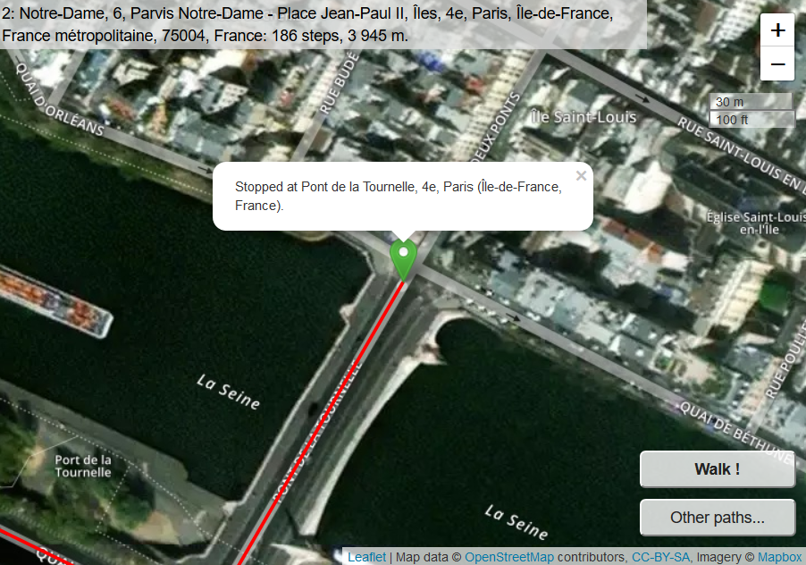 Every time you click on Walk, the drunkard, or let’s say the robot, walks 50 steps (where a step means going from one OSM node to the next OSM node on a way). At every corner it chooses one of the ways at random (trying to avoid directions he took very recently).
I guess I am the first girl child to map from OSM Nigeria community and else where.Its fun and exciting to map with mapswipe,identifying buildings in zambia on a satellite imagery.I needed a phone from uncle victor to play games,and he actually gave me to do so.But later,he mentioned that the phone is used for mapping,I became eager to learn .I got into it and discovered it was like a game giving me scores for good swipes made.I mapped and scored …. The next day I joined uncle Victor to the office where UniqueMappersTeam members were mapping and i could not see myself being idle ,watching while they map.Maybe,If I map,uncle victor would give me a phone or get me shawama.So i watched the video on how to map,and watched Blessing mapped and she helped me to learn how to map,then .I started mapping carefully,using her OSM account. Later,when Blessing Oshoma left,Emmanuella wanted me to continue mapping using her OSM account and I said no,I need my own account created and wow ,she helped to create an acount for me and there I go mapping on OSM!!! Any one there,,,,,,,in high school junior mapping on OSM in Nigeria and else where..? I want to know,otherwise,I guess I am the first girl child of 9 years of age to join this community to map for people in need.Thanks to mum for giving me the opportunity to spend my summer vacation in Port Harcourt with uncle Victor,the team coordinator of UniqueMappersTeam,Nigeria As I go back to Owerri today ,I am going to share with mum and others about UniqueMappersTeam and OSM.And I will also share with my fellow students as I resume for Junior secondary school,class-1 Thanks to Uncle Victor,Aunty Onyi,Blessing,Emmanuella and UniqueMappersTeam for giving exciting time this holiday period.
Dear all,
Yesterday, v4.14.0 of the OpenStreetMap Carto stylesheet (the default stylesheet on the OSM website) has been released and rolled out to the openstreetmap.org servers. It might take a couple of days before all tiles show the new rendering.
Changes include
Thanks to all the contributors for this release.
For a full list of commits, see https://github.com/gravitystorm/openstreetmap-carto/compare/v4.13.0…v4.14.0
As always, we welcome any bug reports at https://github.com/gravitystorm/openstreetmap-carto/issues


