Diary Entries in English

Recent diary entries

Posted by zmb5000 on 25 January 2018 in English.

Hi there!

https://nominatim.openstreetmap.org/details.php?place_id=67004910

The address attached to the link above is misspelled. This misspelling is causing some issues with the project my team is working on. If needed, I can provide more information as to what issues are being caused, and provide a picture/pictures as well. Please let me know what I can do to help correct this issue. Thank you.

Location: Azalea Park, Orange County, Florida, 32807, United States
Posted by contrapunctus on 24 January 2018 in English.

Today I mapped my 200th bus stop in Delhi, which makes up 42% of the bus stops there. [1]

As my edit history must make apparent, I’m mapping like mad these days, which sort of worries me. Nearly all the edits I see in my region’s history are mine, excluding the gigantic transcontinental commits.

Haven’t met any local mappers yet. It’s not the easiest thing to do, given that all the nearby accounts I’ve seen are either non-contributors or simply profile spammers. I’m aware of Nearby users and the tools it mentions, and I’ve given them a spin…I guess I need to put in more effort.

[1] I obtain these figures by using the Overpass Turbo query “(highway=bus_stop or public_transport=platform) in Delhi” to download in a fresh instance of JOSM [2], selecting all the objects, and looking in the Authors pane; I need to discount two bus stops which I mapped as areas rather than the usual nodes.

[2] Back to using JOSM, but now in conjunction with OsmAnd and with less Osmtracker. The time finally came for me to start making bus route relations instead of just writing down bus routes in note= fields.

Posted by GOwin on 24 January 2018 in English. Last updated on 28 February 2018.

The areas surrounding Mayon volcano is still in Alert Level 4, which means an imminent hazardous eruption is expected.

Mayon Mapping Status, 2018-024 https://tasks.hotosm.org/project/4037

We’d like to share the progress of the hard-working humanitarian volunteers who has already mapped 91% of Mayon’s Extended Danger Zone 0. Last week, volunteers also completely mapped Mayon’s Permanent Danger Zone 1. We’d like to especially acknowledge the big mapping boost we got from the DevSeed data team from Peru.

The southern section of the EDZ, considered as high priority because of the settlements within, are now 100% complete, and validated.

See full entry

Location: Camalig, Albay, Bicol Region, 4502, Philippines

Some reasons:

  • I like visualizations, arts, and maps!
  • I have enjoyed the Sotm-eu 2014 Poster Competition
  • I have printed some of them ( color A2 size) - and reusing all the times the best posters!
    • I put on the walls in the local Foss4g/OpenSource conferences - and the visitors like it!!!
      • This is a core of our “Tile Based OSM presentation”! ( and a Minimal Viable Marketing )

So please organize a “Poster Competitions” in the State of the Map 2018 again!

I need new posters for our marketing actions! :)

Imre

// member of the OSM Hungary

One of my favorite from SOTM-EU2014 ( OSM Pop Art by @leopardengruen ) OSM Pop Art

Original size for printing - OSM POP Art

As a positive result from the GIS/Remote Sensing Semina,Miss Salome,M.Sc Student,Animal and Environmental Management Biology,went back to her department and informed others about UniqueMappersTeam of Africa!!!!! And there comes immediately,Sylvia Ezinne Egbom,a Phd Student,Deaprtment of Animal and Environemtal Biology,University of Port Harcourt,who is working on:Mapping of Malaria Parasitaemia/case events to join UniqueMappersTeam as a members ,being excited and ready to learn and start mapping. I had to add her to our whatsapp chat:LetGirlsMap for ladies’ mappers and then Let’s Map our World Chat group-our general chat group.Sylvia introduced herself and was welcomed by many of the ladies and female students in the LetGirlsMap chat group. It was not long when, Rebecca Firth,OSM-Working group and HOT Community Partnership Relations Mananger,came on board to create excitement in the chat group as she welcomed the new female Phd researcher,and started giving her links to facilitate her research on Malaria mapping!!!! starting with the team in Colombia doing malaria mapping:http://blog.openstreetmap.co/2016/o7/13/mapathon-guap and lots more!!! You can imagine the excitement as students of Animal and Environmental Bilogy thumbed up in the chat group with this power of global networking and connectivity provided by OSM community and UniqueMappers of Africa,University of Port Harcourt. Thank you so much Rebecca Firth for being there for us in the chat group:LetGirlsMap ,You are doing a great job!!!!Keep the good work!!!!

Posted by Amalu_Susan on 22 January 2018 in English.

I came to know about OSM from Aruna, she was a speaker at Swatantra’17 (International Conference on Free and Open Source Software) in India. Now she’s a close friend of mine :) After the conference we got connected through telegram.

I really wished to do FOSS contributions but didn’t know how! Glad that I met Aruna, the most patient and cheerful person I’ve met. She asked me to take the first step towards FOSS contributions by OSM tracking. I decided to work out this task with my cousins. We decided to go for an evening and take notes of shops nearby to add them to tracklists. We had fun. Following are some fun things that happened:

1) An old lady asked me to buy groceries from her shop in exchange for the information she shared. 2) A shopkeeper asked for an ID Card to confirm that my intention to take photo of the shop was not bad. 3) I even went for a scooty ride to track schools in the rural parts of my village :)

Posted by jæwesome on 22 January 2018 in English.

dipping toes into the OSM pool. 11 random edits in a quick session. Added some pools & fleshed out some data for water towers. Came across an antenna quandary. Added part of the Putah Creek drainage ditch. Slowly getting an idea of what is going on, considering how to scale edits up

here is stream of conscious musings: so I’m adding this ditch, I specifically didn’t touch the powerline but it’s showing up in the editchain?? did I bump it or is it because the thing I’m adding crosses it?

also I’ve added some cellphone Antennas that are bolted onto the side of the theatre downtown on F & 1st . The closest I can get is man_made=mast They are just additions to the building but noteworthy infrastructure. How should I quantify this in OSM? comm_tower ? cell_antenna ? please advise best course of action

when I try to draw in some of these swimming pools if I get complex it won’t give me swimming pool, I have to make it less nodes. Any ideas? Upon further introspective this seems to be UI clunkyness furthered by my mouse interactions… you know what they say

is there a way to note art pieces integrated into buildings, or for that matter inside. The life sciences has a 4 story double helix in a stairwell facing the exterior. Any way to note that on OSM effectively? I know interior isn’t what it’s all about just wondering

Its so exciting to see the progress of my research about VGI and Crowdsourced mapping becoming a passion-driven campaign for humanitarian mappers among the University Youths in Nigeria. When,It become obvious last year,2017,that I am going to rely on the openstreetmap platform for my crowdsourced mapping research ,the next issue was ,how to raise the crowd and engage them to mapping.My research linked me up to the OSM community in Africa ,where, I met a good friend Geoffery Kateregga ,who was organizing the State of The Map African Conference in Uganda last year,2017. I was introduced to OSM Africa working group and though I was unable to secure travel fund to Uganda for SOTM-Africa,i got on with the community meeting and online discussion with the help of Mr.Geoffery Kateregga.I also got in contact with Nathelia of Mali and Madam Janet Chapman of Crowd2Map Tanzania,all on whatsapp chat,communicating and receiving motivations for work. I was able to create .mentor and coordinate to full establishment ,the UniqueMappersTeam-University of Port Harcourt,Nigeria,as a YouthMappers Chapter between June and December,2017 Our first Mapathon in July had an attendance of more than 100 students and staff ,signing up for OSM account to join us as a humanitarian mapper.

See full entry

Today I created a draft tutorial on how to modify the standard OpenStreetMap Carto stylesheet to use road colours that commonly appear on maps in the Republic of Ireland and the United Kingdom. This simple tutorial is available with two shield styles, as shown below:

Simple colour change

See full entry

Location: Strand-on-the-Green, London Borough of Hounslow, Greater London, England, W4 3RE, United Kingdom

Very active mapping activity around Mayon, in the last several days.

We are grateful for the help extended by very dedicated mappers all around the globe, for helping map the Permanent Danger Zone around Mayon. This has been 100% validated today.

Mt. Mayon is still a looming threat for many towns and small settlements in its vicinity, and we have an on-going mapping project to map the Extended Danger Zone. And because of the positive response from the community, we’re now halfway done, and would welcome extra helping us to make this complete as soon as possible.

Kudos to Maning Sambale for initiating this activity, to make available Free and Open geodata to local governments and humanitarian organizations for their disaster management planning, and response.

Thank you.

Location: Camalig, Albay, Bicol Region, 4502, Philippines
Posted by imagico on 19 January 2018 in English. Last updated on 25 January 2018.

Some time ago i reported here my impression of the first public OSMF board meeting and i kind of feel motivated to make another report on the most recent meeting.

I have attended quite a few of these meetings as a guest in the meanwhile and in most of them there were very few people listening in - rarely more than one or two in addition to myself. Listening to these meetings gives you a bit of insight into how the board ticks, how they communicate and how they make decisions. The last meeting had a quite extraordinary number of visitors and also seemed quite a bit different in several aspects. You can read up the formal minutes of all of the meetings on the OSMF wiki - what i here want to present is my personal impression and commentary on the thing. This is my subjective impression so there are certainly things i understood in a different ways than others and there are likely things i missed because i did not pay attention to them. If you want a neutral record of the meeting look at the minutes or better yet listen in on the meetings yourself.

Let me start by thanking the board for continuing to hold the meetings in public, i think this is of fundamental importance for connecting OSMF politics to the OSM community base. This diary entry is my contribution to this discourse - both by communicating my impression of the meetings to a larger audience than those who were able to be at the meeting and to provide feedback to the board on how their work is perceived.

It was the first meeting after the last board elections so there was the selection of officers - which was ultimately uninteresting because the same people as last time were elected.

See full entry

I just noticed an interesting thing. If you want to create a point indicating a garbage dumpster (trash container or whatever similar) using iD with the English language interface, you add a point geometry and then start typing “garbage” in the Search field. Once you’ve typed “gar”, found tagging options will be related to anything “garden” and “garbage”, but there will also be a “ॐ Hindu Temple” as a sixth item. If you type one more letter and make it “garb”, you’ll have everything “garbage”, but Hindu Temple will jump to the second place.

I’m not claiming that I know how it works, but I assume that there are keywords tied to an interface language and to every tag or set of tags for a specific object. They seem to be language-dependent (while it is still possible to type something in German, like “wald”, and get Wood as an option), otherwise, there would be a lot more confusion with similarly spelled keywords from different languages.

However, I don’t see any logic in this specific situation. As Wikipedia says, “Garbhagriha” is a Sanskrit word for a part of a Hindu temple (not even for a temple itself). How often might it be typed in Latin alphabet by iD users? Does it really belong to English interface, keeping in mind that English is not the main language in any of those countries where Hindu religion is prominent enough? It definitely belongs to Hindu and some other languages, but English? By the way, if you try typing “altar” (also a part of a temple in many religions) - nothing related to temples or cathedrals will pop up. Considering this logic, Hindu Temple should not show up on a list after typing “gar” or “garb” in a search form.

Just to be clear: I don’t care if it will continue popping up - it looks amusing to me, not just “wrong”. I’m not going to dig into iD’s complicated structure and register on any translation services to fix that.

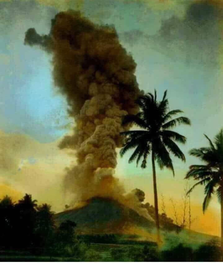
Mt. Mayon ash plume. Photo credits: unknown.

Mayon, the Philippines most active volcano, with 48 historical eruptions is restive. Over the weekend, tremors, lava fountaining, and lava collapse events has been noted. Government volcanologists report that “relatively high level of unrest as magma is at the crater and hazardous eruption is possible within weeks or even days.

The authorities has prohibited the public from entering the 6 kilometer-radius Permanent Danger Zone (PDZ), and the 7-km Extended Danger Zone (EDZ) on the southern flanks “due to the danger of rockfalls, landslides and sudden explosions or dome collapse that may generate hazardous volcanic flows.”

Yesterday morning, we appealed for help to map the 6-kilometer Permanent Danger Zone of Mayon, and the community responded quickly. Today, it’s been 100% mapped, 57% validated (and still on-going). Thank you! The names of the generous mappers may be found in the project dashboard.

See full entry

Location: Camalig, Albay, Bicol Region, 4502, Philippines