Diary Entries in English

Recent diary entries

Posted by pnorman on 25 November 2017 in English.

I’m Paul Norman, OSM user pnorman. I’ve been mapping since 2010, and involved in other facets of OpenStreetMap since 2011. For the last three years, I’ve been on the OSMF board, and am running for re-election. During my time I’ve seen the board grow in productivity, the finances become more stable, and us make good strides in transparency.

Outside the board, I’m also involved with the OSMF on the Data Working Group, License Working Group, and Membership Working Group. As a software developer, I’m a maintainer of OpenStreetMap Carto and osm2pgsql, as well as being involved in many parts of rendering toolchain.

In my work life I’m an independent software developer, working on map rendering, cartography, and PostGIS for clients. My main contract right now is with Wikimedia Foundation, as the developer on their maps team. In the past I’ve worked for CartoDB, Mapquest, and other companies.

Looking back at what I put in my 2014 manifesto, I’m moderately pleased with the progress we’ve made in both transparency and productive board meetings. Neither are perfect, but they’re a vast improvement over three years. Overall, I’m satisfied with my time on the board. I accomplished some of what I wanted to, and think my manifesto desires were realistic.

My concerns are now

Conflicts of interest

6/7 board members work with OSM somehow in their jobs. This includes four with employers who sell services based on OSM data and can easily run into conflicts of interest. We are not managing this, which might have worked in the past, but is not a good practice. There’s stuff we need to set up like having an email discussion out of sight of the people with conflicts. Right now it’s considered acceptable for a board member to take part in discussions where they have a conflict of interest. Clear rules would also protect board members from pressure from their employer.

See full entry

Location: Glenbrooke North, New Westminster, Metro Vancouver Regional District, British Columbia, Canada
Posted by GOwin on 24 November 2017 in English. Last updated on 14 January 2018.

Earlier today, we (belatedly) celebrated Geoweek 2017 with students from the University of San Carlos of Talamban, Cebu. Many thanks to Ms. Rose Lapad (Cebuano Studies Center) and Ms. Lalia Labajo (Chairperson, Department of Anthropology, Sociology and History) for accommodating the mini workshop to introduce OpenStreetMap to their students.

We were able to do basic editing with iD, work with the Tasking Manager, and capture a few Mapillary imagery of the campus, plus the usual Q&As for beginners. >Group photo of participants of the Geoweek micro-workshop. © 2017, Debra Ouano. >image

See full entry

Location: Talamban, Cebu City, Central Visayas, Philippines
Posted by Noznoc on 23 November 2017 in English.

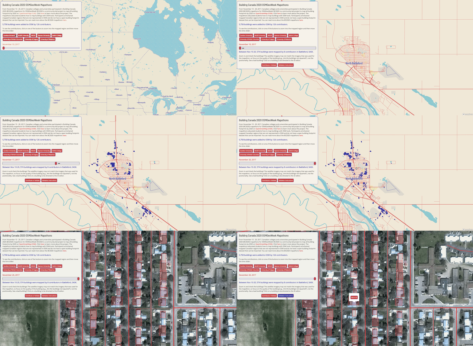
North Battleford, SASK, task (You can see the visualization here and this entry can also be seen on my website.)

BC2020

Building Canada 2020 project (BC2020) is a community-led initiative driven by a simple and clear vision: map all buildings in Canada on OpenStreetMap (OSM) by the year 2020. While interning at Mapbox, the Community Team supported my participation in the BC2020, but but my involvement actually initiated from my work at Statistics Canada on the Crowdsourcing project, as well as my personal interests in volunteered geographic information. For more details about the project, check out the Mapbox “Points of Interest” blog post I wrote.

See full entry

Posted by farhadGuli on 23 November 2017 in English. Last updated on 25 November 2017.

I’m from iraq kurdistan,zakho,batifa, I love this site its very useful, by this I added many roads and new places to my unknown town called batifa, I love the way you accept all our new suggestions about adding new place and roads. I’m happy for helping with you, openmapstreet its NO1 best map site.

Alt text

See full entry

Location: Avatika, Batifa District, Duhok Governorate, Iraqi Kurdistan Region, 42011, Iraq

Dear participants,

Thank you for helping science and supporting voluntary geographic contents. The contents which have been exclusively collected by voluntary efforts. In these contents, public with local knowledge is the main source of information. Thus, we are (as a computer scientist) concerning with human cognition influence on data classification. Human perceives things differently.

For example, regarding landuse/landcover classification, we could agree on that a parcel of land is covered by grass or water which is an abstract level of classification. However, whether this parcel is a park, a garden, a cemetery, or even a golf court might be perceived differently. Whether this water body is a pond, a lake or a reservoir likely requires finer measures, geographic knowledge, and particular expertise.

Therefore, we developed a study to understand more about how people perceive geographic contents remotely. The study aims to:

  • find out human capabilities to provide landuse data.
  • understand the influence of classification mechanism and schema on data quality.
  • study human behaviors in providing voluntary data, and
  • emphasis challenges of data classification in voluntary contents.

The study takes about 25-30 min. We do not collect any personally identifiable information. Thank you again for your time and your contribution. To participate in the study press here

Don’t hesitate to contact me for further comments and feedbacks.

Best regards,

Dr. Ahmed Loai Ali

loai@informatik.uni-bremen.de

Location: Altstadt, Mitte, Bremen-Mitte, Stadtgebiet Bremen, Bremen, 28195, Germany
Posted by jonisia93 on 23 November 2017 in English.

I became involved in mapping in 2015 when i joined with my fellow youth mapper in HOT. We Mapped some wards in Dar es salaam like Vingunguti , Mwananyamara, Hanannasif and Mzimuni ward on which we mapped some featured like Drainage features, roads, building features also those areas which are vulnerable for floods . Tools which where used were like GPS, JOSM software, Also there were involvement of community members in order to create awareness in the community about mapping. It was very interesting exercise .

I have been an active OpenStreetMapper since 2007 (and an OSMF member since early 2016), and have been organising Mapping Parties in my local city of Brisbane, Australia since 2008 (although both activities were a bit quiet for a few years in the middle there - sorry about that!). I want to join the OSMF Board to primarily help increase representation from the AU/NZ/South Pacific Region, and indigenous populations worldwide, and secondarily to bring my decades of expertise in machine-learning to the upcoming challenges of integrating automated mapping with the local-community focus that should always drive OSM contributions.

Since coming back into OSM solidly in the last 5 months, I have re-caught the mapping bug big time. I have mapped locally, and across the world for the Humanitarian OpenStreetMap Team, every single day since July! I am working on re-ramping up my involvement in the project significantly, and I am performing outreach in the local spatial community to increase the awareness of both OSM and the Humanitarian OpenStreetMap Team. I particular enjoy teaching and introducing new members to the project, and have run two Missing Maps events, alongside other local Mapping Parties, and I will continue to organise events locally every month.

I am an active participant of HOT mapping efforts, and I believe strongly in the ability of remote mapping to provide a great starting point for local communities to take ownership of their maps. In fact, I believe that this is the first and foremost principle of OpenStreetMap, that if anything is taking away, or discouraging, local ownership of the map it is probably not a good idea.

See full entry

Location: Brisbane City, Brisbane, Queensland, 4000, Australia

Hello, my name is Chomba Chishala, I am a student doing Environmental Education at the University of Zambia. At the same time the president of the YouthMappers at the University of Zambia Chapter (YMUNZA) I came to know YouthMappers through Open Street Map Zambia (OSMZAMBIA) in February this year 2017 when OSMZAMBIA had a meeting in Lusaka’s Bongo Hive training center. From that meeting, I learnt how to use different tools when mapping including the importance of the maps and how maps can be used for humanitarian help.

As YouthMappers UNZA, we have been involved in different tasks or activities and some of the prominent tasks that we have been doing include the malaria elimination where we have been mapping buildings / houses to help people who are into spraying for malaria as well as distribution of mosquito net as well as mapping for urban and rural areas in Zambia.

Many communities especially in African countries remain underdeveloped due to geographical impediments such as Hills, Mountains and lack of information with regard to how they are distributed especially their location that act as a hindrance to people willing to help in case of an outbreak of a disease.
Thus mapping buildings, roads, and streams as well as showing their actual location and potentials has derived me to engage myself in mapping as many communities as possible for the betterment of most of the communities. ‘’I am a proud YouthMapper who is willing to make a change, just urging everyone out there to join us and make a difference.’’

“As YouthMappers UNZA, our vision is to cultivate a generation of young people to become leaders in creating resilient communities and empowering them to define their world by mapping it.”

Posted by Jabahum on 21 November 2017 in English.

The link below contains the activities that Good Mappers participated in to contribute to OpenStreetMap. http://mapuganda.org/recent-activities/how-youth-mappers-at-busitema-good-mappers-are-taking-osm-to-secondary-schools-in-eastern-uganda

It is a fun venture to teach what you love to do and what do you is a voluntary cause to human development and sustainability. Good Mappers Busitema engaged very well in what they do best and extended mapping skills to secondary school students especially girls at Tororo and also introduced it to new campus students in the university with an aim to grow the community in the university and at large of the youthmappers spread across the globe.

Location: Busitema Trc, Busia, Eastern Region, Uganda

On 3rd July 2017 i joined the youth mappers chapter at IRDP and elected as a vice president of the chapter. The introduction of this chapter to our collage has made me realize how important it is to do mapping for risk areas and allocating various social service thus becoming easier for aid provision and security as well as other communal services. GIS and mapping are my core interests therefore joining this chapter will bring me great experience and influence to these two media.

Location: Dodoma, Dodoma City, Dodoma Region, Central Zone, Tanzania

I joined the Youth Mapper Chapter on 3rd July 2017. I became very interested with joining the chapter since i need to acquire more skills with mapping and GIS at large also i joined the chapter because i was interested in doing volunteering work of mapping areas that can be use to reach with fast aid to the people. Apart from joining the youth mapper chapter i appreciate the network that is going on between the youth mappers allover the world also i was great full for the seminar that was held at our university Mipango Dodoma that was conducted by Benedicto via him a lot of experience i acquired .

Location: Dodoma, Dodoma City, Dodoma Region, Central Zone, Tanzania
Posted by Wava Stella on 21 November 2017 in English. Last updated on 22 November 2017.

As a volunteer through Youth Mapping, I have engaged and experienced a lot of interesting projects, mapathons, workshops and training. Started with a HOT Project for mapping for malaria elimination in Zimbabwe Southern Province and Zambia. Ignoring the inconsistency in my diligence, I still manged to deliver awesome and come up as one the good mappers on the project with an appreciation from HOT. A lot of projects followed for which my contribution was mainly remote inclusive the project for response to refugee crisis in Northern Uganda through a number of mapathons, use of some tasks to train on the other members interested in the realm of mapping. Many more project tasks including #Hurricane Irma, #Kasese Floods and a lot not mentioned. And now we have embarked on the #Saving Mothers giving birth in Kyenjojo, Uganda. However, with all these projects and training conducted, JOSM has emerged my best platform for savoring the mapping moment.

Location: National Housing Flats, Kampala, Uganda
Posted by Mbabani Allan on 21 November 2017 in English.

Adding a missing map to OSM.

This week (20th-25th/ November) decided to add a missing area on to the OpenStreetMap, and I zeroed down to a village located north of Busitema University hidden by the Busitema Forest.

This village is called [Habuleke] (osm.org/#map=15/0.5576/33.9858) and visited it once during the Mapillary Challenge in May 2017.

Location: Central, Kampala, Central Region, Uganda
Posted by Laura Mugeha on 21 November 2017 in English. Last updated on 30 August 2020.

We organized a mapathon where female student mappers came together to make a difference in their country, and the world at large through their mapping efforts handling a task that focused on Siaya County, a region that borders Lake Victoria. The exercise mapped buildings and roads for HIV/AIDS prevention and treatment programs. The long-term impact that the exercise would provide necessary data to the U.S. President’s Emergency Plan for AIDS Relief (PEPFAR) program to find and help those suffering from HIV/AIDS. The initiative would be able to identify the location of communities and how they are connected by roads to HIV/AIDS prevention and treatment services in the area. By understanding the program coverage, the initiative is in a better position to optimize their supply chain logistics, which in effect, would help them meet their mandate.

Blog post: http://www.youthmappers.org/single-post/2017/10/23/Mapping-bridges-the-gap

Location: Jambo, Juja ward, Juja, Kiambu, 01001, Kenya
Posted by Laura Mugeha on 21 November 2017 in English.

This involved the mapping of roads and buildings in the Mara River Basin, based on satellite images, on OpenStreetMap. The maps produced during the Mapathon, are to be combined with knowledge, tools, and data from the MaMaSe program and Ground Truth 2.0 thus improving Integrated Water Resources Management in the Mara River Basin and prevent famine in the future.

Blog post: https://geosymp.com/mara-mapping-party/

Location: Jambo, Juja ward, Juja, Kiambu, 01001, Kenya