Diary Entries in English

Recent diary entries

Posted by Zainab Ramadhanis on 9 January 2023 in English. Last updated on 20 June 2023.

November 2022 was such a pleasant moment because I participated in the State of the Map Asia for the first time. I always wanted to join the SotM in person since 2020 after participating in lightning talk SotM 2020. In 2021, I didn’t have chance to submit my research result because I just finished it on early July. So, I proposed myself as a translation volunteer for Bahasa Indonesia (see SotM 2021).

In 2022, I also planned to join SotM 2022. However, I couldn’t join because I was very busy with my thesis and had to graduate before September 2022. I thought I didn’t have a chance to join any OSM event in 2022 before my friend sent me an Instagram post that Open Mapping Hub Asia-Pacific was looking for scholars. There were three categories of scholars: community nomination, mapping, and map-making poster. I decided to submit in map-making poster category because I didn’t participate at all in OSM local community in Indonesia since I lived in Taiwan to study, and I didn’t contribute much to OSM in 2022. I created the map-making poster about the quality of road data OSM in Jakarta by comparing the OSM data and local government data (see my poster here). Thank you Open Mapping Hub Asia-Pacific for this amazing chance!

I arrived in Legazpi City, Philippines on Sunday, November 19, 2022. Mayon Volcano became the first thing that I saw when I landed at Legazpi Airport. The scenery of Mayon Volcano was very beautiful, I didn’t take a proper picture at that moment, but I took a good one when I visited the Cagsawa Ruins on Tuesday (11/22).

State of the Map Asia 2022 was actually different than any SotM Asia events before, as it collaborated with Pista ng Mapa (Festival of Maps), so the conference was quite long, five days in total. But I didn’t complain, because all the presentations and workshops were totally fun!

See full entry

Location: RW 02, Gambir, Central Jakarta, Special Capital Region of Jakarta, Java, 10110, Indonesia
Posted by NorthCrab on 9 January 2023 in English. Last updated on 11 August 2023.

Tool demo

I released a new tool called osm-revert for OpenStreetMap community. It’s aimed to be a direct successor to RevertUI. It’s a faster and smarter way to revert changesets on the platform. It uses the Overpass API to reduce the amount of API calls, making it faster at reverting changesets. It can also automatically resolve conflicts, something that the previous tool, RevertUI, couldn’t do. Plus, it has no limits on the size of the changeset. This solves problems like changeset too big and node and way conflicts.

See full entry

Hi all, I’ve written a new post based on OpenStreetMap data on roads, landuse and other features in Australia, to answer the question: is the total length of roads within towns and cities less or more than the total length of roads between towns and cities. Town boundaries were generated from OSM’s landuse, leisure and other tags. Hope you find something of interest. Cheers.

https://little-maps.com/2023/01/09/city-or-the-bush-where-are-the-most-roads/

Have you ever taken a look at your own mapping done over a year or two ago? If you haven’t yet done that, take a few minutes and check out some old projects or areas you have mapped. A few questions you might ask yourself upon a glance at your own mapping would be; Did I really map these features?; What happened to my mapping skills?; How could this happen? Of course! that is you.

But you should rest assured that is not your doing. I came across an area mapped by an experienced mapper who was and has been my inspiration since I joined the OSM community and at the first glance I was disappointed. But upon checking the history of the mapped features, I realized the digitization was done years back.

This realization brought back theories I learned in class during my undergraduate studies. “Maps do not stand the test of time”, meaning they are easily outdated. But this is true when it comes to paper maps since it takes a lot of money and effort to make them and yet they do not last in terms of representing newer environmental development.

Its a different story for OSM, yes area never gets mapped, but we can constantly keep updating data to catch up with the ever-evolving and ever-changing environment so that the world does not classify OSM data are not good enough. Let’s Keep Mapping Daily, The Work Never Ends!

Location: Obenyade, Tema, Tema Metropolitan District, Greater Accra Region, Ghana

I’ve run across a few places where there seems to be some disagreement and confusion about how to distinguish between roads that should be tagged as highway=service versus highway=track. I see quite a few ways that get switched back and forth between the two tags each time a different mapper touches them.

So I figured I’d write up how I make the distinction. I understand that other mappers might think about these things differently, but here’s how I think about the two types of roads.

Service roads (highway=service) are:

  • used to provide motor vehicle access from a through road or a local road to a specific destination (building, etc.)
  • typically very short
  • typically used for a single purpose
  • often one lane (although sometimes wider)
  • typically not named or numbered (i.e. no name or ref tags)

Some examples of highway=service: a driveway, an urban alley, a parking aisle, a short access road for utility equipment, an access road leading to one or more campsites, or an access road in a municipal dump.

Track roads (highway=track) are:

  • local roads that are only wide enough for a single four-wheeled vehicle (i.e. dual-track on the ground)
  • can be short or long (i.e. many miles)
  • typically used for multiple purposes
  • typically named and/or numbered when they are approved public routes of travel

Some examples of highway=track: a dual-track dirt road, a remote single-lane paved road, a graded single-lane road along a canal or railway, or a dirt road along the path of a power line.

The place that seems to cause the most confusion is where a longer road is used to access some sort of infrastructure. For me, this is typically a highway=track. Although roads like this can be used to access infrastructure (e.g. towers for high-voltage power lines) they can also be used for through travel, recreation, and other purposes. Roads like this are often designated for multiple uses by the land manager responsible for them.

See full entry

Posted by SK53 on 8 January 2023 in English. Last updated on 11 January 2023.

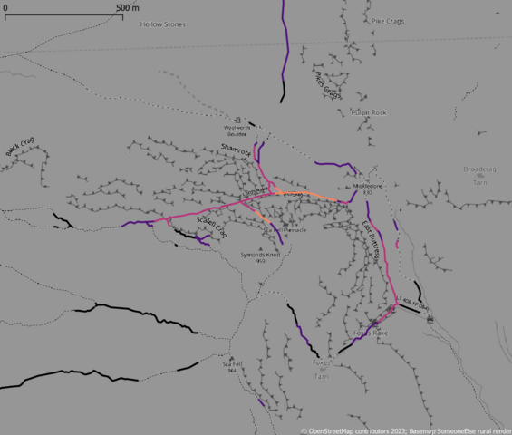
Recently there has been quite prominent press coverage of mountain rescue incidents in the English Lake District involving people using various outdoor activity apps (The Guardian, Grough). It turns out that these incidents involved paths mapped on OpenStreetMap, and have been discussed by the local UK community.

Steep paths on OSM around Scafell (brighter is steeper)

See full entry

Location: 54.449, -3.223
Posted by SimonPoole on 8 January 2023 in English. Last updated on 2 May 2024.

I haven’t done a contributor statistics diary post in a long time, but I suspect that the latest update of the graphs on the wiki is likely to lead to some questions.

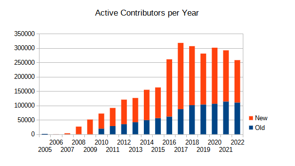
As we can see in

active contributors per year

the number of new contributors to OSM has dropped quite a bit in 2022. As the overall number of contributors has always been dominated by the new contributors it isn’t a surprise that the overall number is down too.

The interesting question is if we can pinpoint any “source” of this reduction. As a 1st investigative step I gave the numbers for editing apps used by new editors a look. I’ve been producing the numbers for a long time, but have never published them previously, if we look at 2021 and 2022 we see:

See full entry

Posted by Quite Frankly on 8 January 2023 in English. Last updated on 22 September 2023.

I am embarking on a project documenting and updating bike lanes throughout Melbourne, and eventually Victoria, in as much detail as possible. This work draws on a range of sources including aerial imagery, street-level imagery, local surveys, other OSM users, and input from councils. I am drawing on global tagging conventions, and other tagging schemes developed specifically for detailed documentation of cycling infrastructure such as here and here.

In the first iteration I will capture the most basic attributes, such as whether a lane exists and if so, what basic category, e.g. exclusive, advisory, shared, separated, etc. If a survey reveals no lane, I mark the way explicitly as cycleway:side=no. Otherwise, the type of lane is captured using cycleway:side=? and cycleway:side:lane=? (side = both/left/right, depending on the way). See this tagging guide for specifics.

This step in itself is quite a large undertaking, and I’m finding even this basic categorisation can be somewhat subjective in cases where cycle lanes haven’t been properly maintained or markings are particularly sparse or unclear. I will post some examples of these edge cases in due course.

Note that where a cycleway tag already exists on a way, but I cannot validate its accuracy, I will not remove the tag. I will only update existing tags if I can confirm the tagging is incorrect, outdated, or could benefit from more detail (such as specifying :side and/or :lane).

Following this, I intend to add additional attributes such as lane width, buffers, separation type, traffic calming, etc. as well as updating the off-road network. This work aims to support better city planning, journey planning and cycle route suggestions across the state.

I have nearly completed the first sweep of City of Melbourne, City of Darebin, and City of Casey and am currently in the process of validating this with these councils.

See full entry

Location: Melbourne, Victoria, Australia

This is just an initial review and test of the Every Door mobile OSM editor. If you ever added stores and POIs with either a piece of paper and a camera you know that it is a long pain to add all the information to OSM. Even worse is that all your efforts can end up stale and you have to re-fix all the closed or new stores. Enter Every Door, the perfect tool that makes micro mapping or adding / updating POIs a breeze and not just simple things but adding handicap status, telephones, websites, payment information and other fine details are all there. It also has the easiest and seamless Opening hours editor which with a few taps you have it set quickly.

I went back to fixup and remap some shopping centers and places today and it was a breeze. I am able to quickly remove closed stores, quickly add new stores with the easy iD editor presets search and it does everything to streamline the process and give you just the right fields for the given. Adding the phone number is as easy as dialing it, and website as quickly putting in the url no need to worry about the http prefixes it does it for you. This app makes me want to do more field mapping as it takes out all the tedious parts and gets to the exploring and mapping right away with near instant gratification.

If you haven’t already download and try the app. It is for Android and iOS and is even on the F-Droid app store. So try it out I want more people to know about this as I am glad I found out about the app.

https://every-door.app/

Posted by mvexel on 6 January 2023 in English.

After tinkering a bit but finally successfully processing videos from my Viofo A129 dash cam and uploading them to Mapillary, there is one last thing I wanted to try: using the A129 time lapse mode to be able to collect more imagery before the storage space on my camera runs out…

This does not seem to be possible without recording your GPS breadcrumbs using a separate device, because the location information written into the movie stream by the camera is sparser than the video frames. Using

exiftool -m -p gpx.fmt -ee -ext mp4 -w! %f.gpx time-lapse-movie.MP4

I get 4 trackpoints for a movie that contains about 300 frames.

This could also be a result of limitations in the way exiftool parses the MP4 file, but looking at the relevant documentation section I don’t see a way to tweak this.

What I think I will do instead is:

  • Buy a larger micro-SD card (they are getting cheaper all the time)
  • Reducing the video quality

In order to be able to capture more of my longer trips. I’m about to make [this drive] and I’ll test it then!

Location: 40.740, -111.907
Posted by b-unicycling on 6 January 2023 in English. Last updated on 7 January 2023.

Earlier today, I reached my 5 millionth edit. It came to my attention about 10 days ago that I was approaching it, because someone on Twitter had celebrated their 15,000th edit, and I went to check mine on neis-one. I then estimated that it would take me 10-14 days to reach it, and I was right.

My friend DeBigC had given me some praise already in his diary some days ago.

Next stop, 10,000,000, I think. Well, not really stop, just a goal.

It’s not that difficult to get that many changes when you’re working on a big project like Irelands #osmIRL_buildings project. We started on Co. Roscommon mid December 2022, and apart from buildings, I’ve already added 1150km of drystone walls. You read that right. dry stone wall statistics from ohsome.org Part of that was discovering several field systems of unknown date, but I have documented the use how I tag them on the wiki. I don’t expect many field systems like that to survive in many other countries, it’s just that history is all over the place in Ireland.

See full entry

Location: Onagh, Taghmaconnell Electoral Division, Athlone Municipal District, County Roscommon, Connacht, Ireland

I run a Mapillary supplied BlackVue dashcam uploading my take via the mapillary_tools in two “stabs”. The first is usually same day for road speeds segments below 55kph, the second is up to 2-3 months later. This gives town/village streets and remote road intersections/signs coverage first, for other mappers. I am also taking 1FPS rear left (webcam) and right angle left images (Samsung phone) at less than 40kph for immediate geotag, process/upload. (after manually culling privates)

See full entry

Thought it worth posting this.

After much frustration I have come up with what I do regarding amenity=parking and highway=rest_area (plus details) and have been running this way for 6-12 months. This is live data input (my eyeball/camera/recording etc) as I drive through. I think there have been maybe 1200-1400 objects so far!

I have generally adopted a formal vs informal data set. Formal is almost based wholly on site signs and informal on a mix of triggers and interpretations.

This generally only applies to regional places, not so such towns and high population areas.

There are always contentions! I have come across many (other mapper) highway=rest_area objects that are not “my formal”, as I make no allowance for locations that “could be”. Indeed any parking area could be an informal rest area, so are informal ones needed at all? In the end I sometimes use informal=yes or informal=no to clarify.

So looking at the SA and WA govt databases and my limited travels, SA calls everything “rest areas” and their naming system starts “RA”. This is also seen on roads where virtually every stop has a rest area sign at 1km before, followed by a “P” or two. WA calls everything “stopping places” with a plain number designation. It’s almost as if “P” locations in WA are not allowed to be rest areas! There is also a distinct lack of HGV defined “P” in WA where I wonder if trucks actually get stuck in small ones! Of course Qld is quite unfriendly in defining large areas with useful facilities as HGV only, but that’s another story!

The “informals” are basically NHVR Green Dot, Stockpiles/gravel pits and any place that looks like a truck has been parking for a few years! I also map gravel pits that “could be” used for parking.

So onto the process.

MAIN DECISIONS

See full entry

Posted by kucai on 4 January 2023 in English.

Recorded a track using opentracker app for a 100km journey through the backroads. Phone was placed as far back on the pillion seat to get maximum view of the sky. No kalmann filter or anything.

The resulting track was very smooth, extremely few jaggies. One particular section of note is at the newly opened elevated highway that is probably at least 10 stories high. Due to the slanted imagery, the traced highway and the gps track differs by about 15 meters. Personally, I won’t bother realigning (although the temptation is very irresistible) - besides somebody else would probably moved it back according to imagery. I learned long ago that trying to get people to check imagery alignment with the provided cm level survey points before editing is a hopeless endeavor.

Still, I am pretty excited with the raw GNSS measurement ability of the phone and intend to set out more survey points just for the hell of it. Waiting for kind, knowledgable people to provide an appimage for the gnssanalysis software since I couldn’t get past installing matlab whatever in its current form.

Location: Kampung Sungai Jernih, Kajang Municipal Council, Hulu Langat, Selangor, 43000, Malaysia

It might sound like a no big deal or a win to some people, but to me, it’s a big one. I became an advanced mapper on OpenStreetMap in 2022.

I joined the Humanitarian OpenStreetMap as a volunteer mapper in the year 2019. Unfortunately, I was not active until 2020, during the pandemic. I was introduced to HOTOSM after I joined the Youth Mappers FUTA Club (an affiliate of HOTOSM) as an undergraduate.

In December 2021, I saw a tweet about volunteers that mapped for over 100 days in 2021 on OpenStreetMap, and I was compelled to take up the challenge. I improved my participation and moved from a beginner mapper to an intermediate mapper. I could not map for 100 days but I had over 50 days, which made me eligible for the OSM Foundation member.

Though it is a volunteer task, I must say that I enjoyed every bit of it. Creating solutions that tend to the needs of humanity and also a blueprint that stands the test of time. Feels like a Super Hero (winks).

And yeah in 2022, I added to my new year resolution, to become an advanced mapper on OpenStreetMap. To achieve this, I started strong by contributing daily to OpenStreetMap. I focused more on disaster responses except when I joined mapathons organized for a different need.

It’s a pleasure to have me mark this as a success in my resolution list, and I won’t stop contributing to humanity using the OpenStreetMap tool.

Posted by TrickyFoxy on 2 January 2023 in English.

Recently, the Every Door editor became available in F-Droid, and I thought this was a great reason to tell you what I like about this editor.

On osm.org does not support video, so the article will be on telegra.ph https://telegra.ph/Why-you-should-try-Every-Door-01-02

Оригинал на русском языке: https://telegra.ph/Pochemu-vy-dolzhny-poprobovat-EveryDoor-01-02

Posted by marnen on 2 January 2023 in English.

I just realized that I should mention here that I’ve been putting a good deal of effort (in fits and starts) into combining osm.org/relation/12907666 with adjacent wooded areas and converting it and the areas around it into multipolygon geometry. It’s a huge job and I only work on it every now and then, but I’m pretty pleased with it as an example of what well-designed geometry can be.

Posted by Ohene123 on 2 January 2023 in English.

I started my OSM journey as a YouthMapper with the University of Cape Coast YouthMapper chapter in 2016. It was very exciting and I loved every moment spent mapping projects on the tasking manager. This increased my zeal in wanting to become a cartographer :) , I can’t tell if it still holds now because I have grown to like the varieties in the mapping field…

Being a YouthMapper was a privilege because I got the chance to work on a project with OpenStreetMap Ghana through our late patron (Mr. James Eshun) which was also very exciting. The project was the Open Cities Africa, Accra Project which was sponsored by HOT. It was in the year 2018 I got to learn about Open Data Kit (ODK) and Open Mapping Kit (OMK). I also got to know about other open source mapping tools such as OSMAnd, OSM tracker and Maps.me. We did some remote mapping using JOSM and ID editor, mapping buildings, roads, POIs etc. and also went to the field to field validation.

After school I then joined OpenStreetMap Ghana as a volunteer and was privileged to be nominated to be part of the board members. As someone who loves to volunteer it was another opportunity for me to learn an also give back to the society.

For the love of contributing to OpenStreetMap, I had the opportunity to join the HOT Data Quality Internship(DQI) in 2020. There I learned more advanced ways of mapping using JOSM and other Open source tool such as QGIS. This sparked my interest in making sure data contributed was of good quality. I again joined DQI in 2021, it was an amazing encounter and another chance to learn about data quality and other open source tools such as OSGeo , Mapillary, Mapbox etc.

Although, I do not mapped as frequent as before, in order to keep myself in check, I joined OpenStreetMap Africa monthly mapathon where I get to map and validate mapathon tasks and also I go to the tasking manager to contribute to urgent projects.

See full entry