 OpenStreetMap

ι’м loѕт wιтн тнιѕ ѕтυғғ!! ☹️
Diary Entries in English
Recent diary entries

This is the fifth in a series of posts which I’m doing inspired by other users’ monthly updates. This is only around a month later, so it’s brief
Catalina Island
In the beginning of December, I did day hikes on Catalina Island, southwest of Los Angeles. The Trans-Catalina Trail is already well-mapped on my route from the airport to Avalon, but I was able to map a few picnic table + shelters, and a one-way drive loop. On the Lone Tree trail, there are several steep points (I was surprised that a Jeep can drive these); one had an unmapped footpath detour (with official signage) around the steepest point. Another point has ~half of a trail. I included it for completeness, and to show that it doesn’t lead anywhere.
Lincoln Park
On the sidewalk I saw a sculpture “Gourd Man” which was missing from OSM. Articles about it typically say that it is in Village Green, but here it is (was it moved? is it a copy?). Anyway I added it.
Posted by JoshuaOrais on 1 January 2023 in English.
Last updated on 3 January 2023.



The damn project helps mappers by dividing some big area into smaller squares that a human can map. This diary is about the work done in the third year since the publication.
And, to be honest, not much has been done. I had a little of time this year. Still, there are some interesting improvements.
Deployment and server
I will start with probably the most boring stuff: I worked on the documentation and tests.
That is thankless work, but I believe it pays off in the longer term.
In short – 35 files changed, 1675 insertions(+), 842 deletions(-) and you, as mapper, should not see the difference before/after.
In parallel, I worked on the refactoring deploy. I have moved some upkeep procedures already and I will slowly continue the work.
Notathons
The most motivating for me, I think, is a feedback with a request like “hey, we are working on this and we need that”.
This time it was from guys organizing notathons.
We improved the damn plugin for JOSM to download notes automatically and periodically.
Also, when using the plugin, the changeset comment is (finally!) automatically set based on the area information.
Get inspired by issues of similar projects
I wrote already about damn project point of view on some issues. From that diary, I think that this issue is solved by option to Review newbie, or Map or review work of other mappers workflow.
Because there are not many issues with the damn project (I do not complain!) I sometimes look up interesting issues somewhere else. So, what is there?
First two here and here deal with locking of multiple tasks (squares in damn) for mapping or validation (review in damn).
Locking of multiple squares goes against the principle of “divide and map” and therefore it is problematic, but there are valid use-cases.
When you need to map multiple squares, merge them first (in mappy client).
Do the same with the squares you want to validate, but it is probably better idea to set which mapper in the damn plugin for JOSM instead.

Few hours to end 2022, so I told my self that it’s a must to pen my experiences in the state of the map Nigeria 2022. It was a wonderful experience as a local Organizing committee member to host the first ever state of the map conference in Nigeria. It seem like an impossibility with lot’s of challenges that faced us, yet we pulled through together with our capacity coordinator Sir Victor Sunday spear heading us. The arrival of our participants and guests hyped my expectations of the conference that I have to put more energy to make it a reality. Indeed it was a reality and amazing one for that matter. My expectations weren’t unmet. I made new and wonderful friends like Petro from Tanzania, Mohammed Ali, Mamman from Abuja, Letwin from Zimbabwe and our wonderful women wing lead Chisom whom I’ve been eager to meet all along. It was like a reunion for unique mappers in general. To all the LOCs Light, Promise, Victor, Chinenye, Joana, you were all amazing and made a rewarding team. Thanks to all our sponsors and contributors to a successful inaugural state of the map 2022. Thanks everybody and Happy New year in minutes.
Few hours to end 2022, so I told my self that it’s a must to pen my experiences in the state of the map Nigeria 2022. It was a wonderful experience as a local Organizing committee member to host the first ever state of the map conference in Nigeria. It seem like an impossibility with lot’s of challenges that faced us, yet we pulled through together with our capacity coordinator Sir Victor Sunday spear heading us. The arrival of our participants and guests hyped my expectations of the conference that I have to put more energy to make it a reality. Indeed it was a reality and amazing one for that matter. My expectations weren’t unmet. I made new and wonderful friends like Petro from Tanzania, Mohammed Ali, Mamman from Abuja, Letwin from Zimbabwe and our wonderful women wing lead Chisom whom I’ve been eager to meet all along. It was like a reunion for unique mappers in general. To all the LOCs Light, Promise, Victor, Chinenye, Joana, you were all amazing and made a rewarding team. Thanks to all our sponsors and contributors to a successful inaugural state of the map 2022. Thanks everybody and Happy New year in minutes.

COMMUNITY WORKING GROUP MENTORSHIP PROGRAMME
Ever felt cold shivers down your spine because of a particular challenge but at the same time you want to face it head on? This was exactly how I felt when Arnalie asked ‘Would you be available to facilitate for your group, Chisom?’ in her sweet subtle voice during one of our Mentorship review meetings.
I was shocked to my bones and I literally had goose pimples all over, I didn’t see it coming. It would be my first time handling such a role and my group members are all experienced persons in the geospatial sector. All I wanted to do was scream ‘Nooo!’ out of fear and uncertainty but at the same time, I wanted to step out of my comfort zone and challenge myself for a change, so, after a little silence while battling with these thoughts in my head, I responded ‘Yes, I’d love to’. After accepting the role, I was encouraged and she told me I could always reach out to her if I need her assistance.
After the meeting, I received a message of my expected duties as a facilitator and all I could say was ‘Lord, help me’.
Gradually, I started initiating conversations on the group slack page (which was one of my responsibilities) and on the 7th November, 2022 we held our first group meet where I was the official facilitator. As the time for the meeting drew near, I got more anxious, I could only hope to get it right.
Fast forward to the meeting and every other meeting and discussion we had as a group via Google Meet and on the slack page, all of which turned out great and smooth, all thanks to my awesome group members; Laxmi Goparaju, Anuradha Rajanayake, Antonin Haas and Charles Chilufya. They were all supportive, never withholding any of their great ideas to ensure we succeeded as a team and together, we were able to deliver our legacy project in good time. I grew more confident with each meeting.

This year I mapped my first POI with a Punycode website: a Japanese cafe/ice cream shop in Brooklyn called Amai Bā (osm.org/node/9795586991).
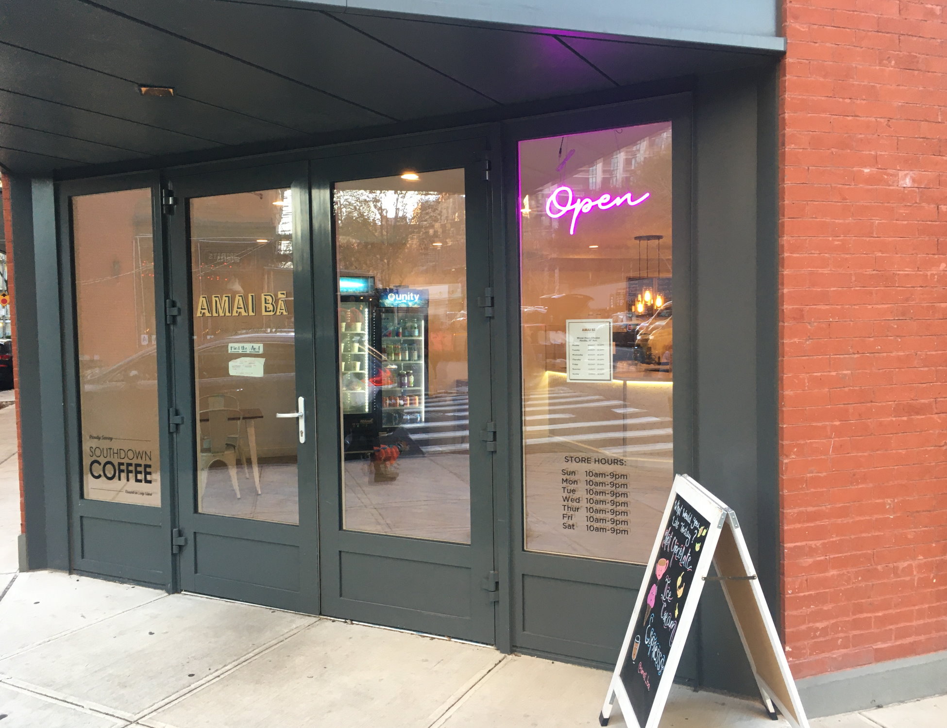
The website is https://www.xn–amaib-jwa.com. This was posted via QR code, taped to the shop window before the cafe opened. I’ve been hoping it would reappear on the permanent signage, but nothing so far – possibly because the website is still an empty placeholder.
Punycode https://www.xn–amaib-jwa.com is the agreed standard RFC 3492 way to encode https://www.amaibā.com. This is necessary because the Unicode character ā (a with macron, used mostly in rominisation of non-Latin writing systems) is not part of the letter/digit/hyphen character set supported by DNS, making amaibā.com an Internationalized domain name. Under the hood, xn–amaib-jwa.com is the “real” domain name, but most modern browsers are configured to show the site as amaibā.com.
SOTM NIGERIA
The State of the Map (SOTM) Nigeria 2022 was the first of its kind to be hosted in my country, Nigeria and it was hosted by the Unique Mappers Network Nigeria.
I can still remember the first meeting we held as the Local Organizing Committee (LOC). There were lots of things we mapped out to do, we created sub-committees, scheduled to hold such meetings every Saturday, and several other plans in order to ensure that the program would be a success.
It wasn’t easy planning such a conference and there were times when I thought to myself ‘what if the program doesn’t turn out okay?’. There was so much we had to do in such little time and it always felt like we hadn’t done enough. However, I’ll continue to be grateful for Victor N. Sunday (Our National Coordinator) and Uchechi Anaduaka (Our Gender Program Coordinator) who were relentless in ensuring that we were all up and doing and that everything that needed to be in place for the conference was coming together gradually.
On 2nd December 2022, the long awaited conference was finally upon us and I was amazed at how our meetings and consistent planning efforts had culminated into such a wonderful event. The attendance (onsite and online), the venue, the refreshments, the paper presentations, the trainings, all turned out great and I am super ecstatic that I was part of the building process of such a memorable conference.
I specially extend my gratitude to Pete Masters, unSummit World Tour Program and Dr. Ibrahim Cisse (Director Western and Northern Africa Hub) for their timely interventions throughout the conference and in sponsoring all the travel grantees (I was one of them).
I am very excited about all that I leant being part of the planning committee for the conference and during the conference. I am also super optimistic that SOTM Nigeria 2023 will be greater and make more impact.
Thank you
Chisom Okwuchi,
Unique Mappers Network, Nigeria

2022 PART 02
##My first State of the Map and FOSS4G (Italy)
When the mail came in, I couldn’t believe it…SotM and FOSS4G all at once…Italy you say – I still think it was a dream!
It was a call to attend the Global State of the Map (SotM) Conference and the Free and Open-Source Software for Geospatial (FOSS4G) Conference in Italy. I didn’t know where to start but I have the Organizers of FOSS4G and my mentor Dr Prestige Makanga to thank in all.
It was the 17th of August when I bordered the plane to Rome. It was a first, overwhelming is the closest I can use but trust me it was way beyond that. My flights got delayed and I got to Rome late, took my trams to Firenze and hail there was a raging storm. The storm delayed my trams too and I got to Firenze around 11pm. Thanks to Cristiano Giovando; he was there all the time till I was right inside the hostel, on my bed and ready for the big day the following day (I’d call him my map, tour guide, keeper and connector). I am very much grateful.

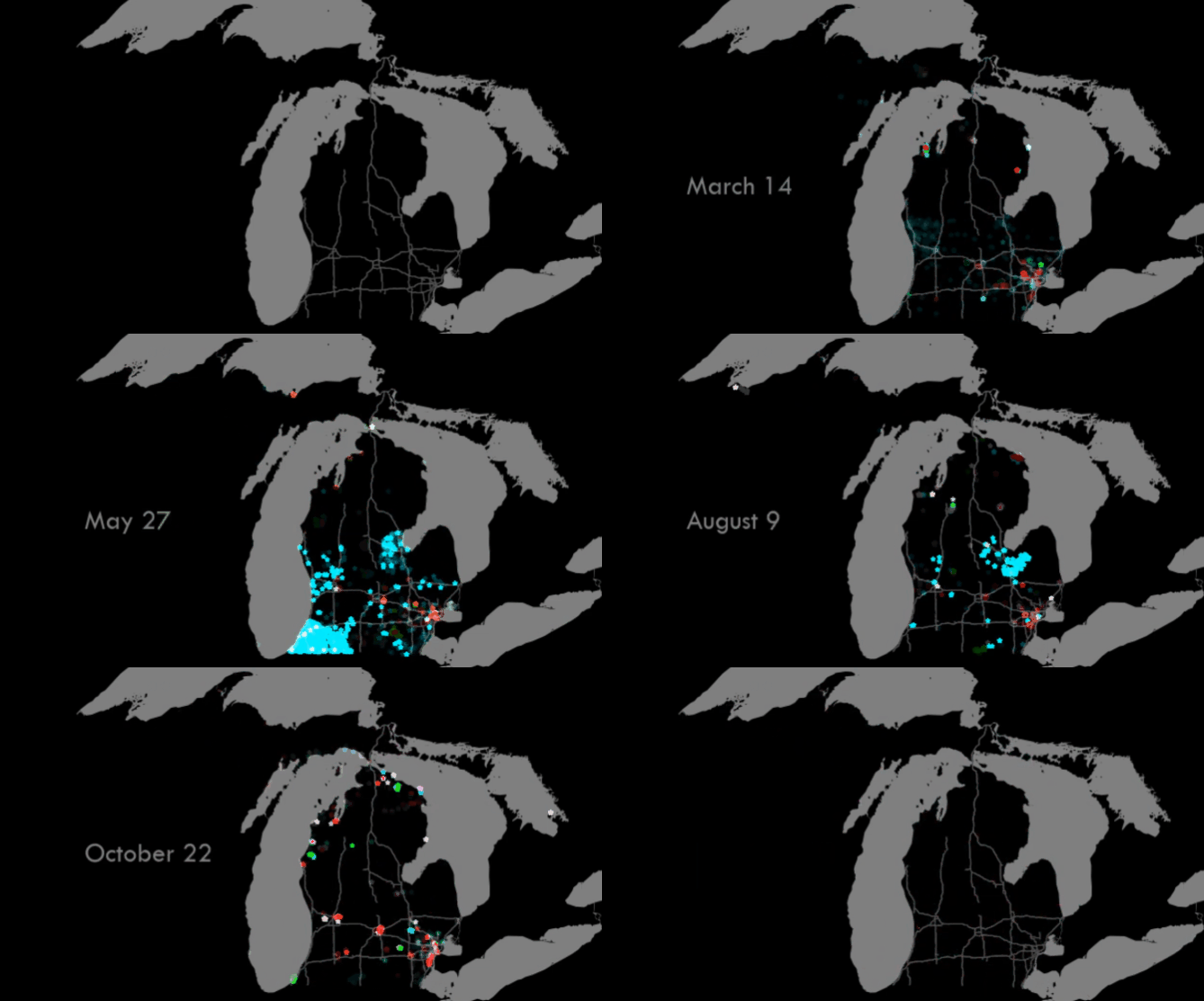
I through it might be cool to see what one year of edits looked like in OpenStreetMap, so here is Michigan from January 1st, 2021 to December 31st, 2021.

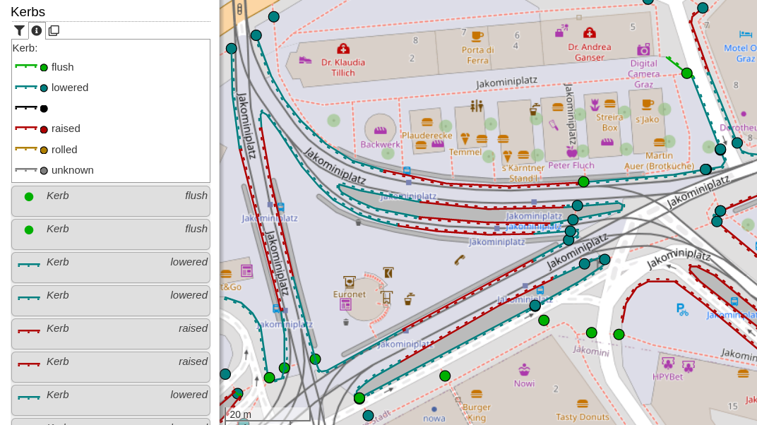
This new category shows kerbs (the edge where a road meets a sidewalk). Read more about this in the OpenStreetMap Wiki. The category uses the colours from the Wiki page. Popups will show additional information: type of kerb (lowered, raised, …), they wheelchair accessibility (if set), if the kerb has tactile paving and the height.
For discussion, please go to the OpenStreetMap Community Forum.
.jpeg)
I want to use this privilege to express my journey to humanitarian open street mappers network Nigeria and unique mappers network of Nigeria. I’m Muhammad Auwal Muhammad I was introduced to Hot#osm network and unique mappers network Nigeria through Mamman Ali in August 2022, the time he notice I have passion in mapping and environmental data collection and also Open street Mappers network introduced me to Unique Mappers Network of Nigeria. When I joined Unique Mappers Network of Nigeria I meet a lot of high profile people that taught and treated me with respect especially our workaholic national coordinator in person of Mr Victor N Sunday. With a bit knowledge I obtained from online class I had with Unique Mappers Network of Nigeria on Mapilary mobile app. I can contribute my quota. I’m ready to work with my friend Mamman Ali to elevate Unimaid Mappers Team and Unique Mappers Network of Nigeria and Open Street Mappers Network in northeast region and also I would introduce more of my friends to Unique Mappers Network of Nigeria and Open Street Mappers Network. We are still working day and night to do official announcement for open ceremony of Nigerian Army University Biu, NUAB Mappers Compus Biu. Looking. I sincerely appreciate the whole members of Unique Mappers Network of Nigeria and Open Street Mappers Network for the guidance and support given to me from day I joined till date, thank you all.

In the past, Mapillary offered a feature to grab a GPX from image sequences. That feature disappeared at some point, but it would still be useful to get a GPX - to use for OSM, upload to Strava or anything else.
Introducing a quick script to do so - mapillary_to_gpx.pl at https://github.com/richlv/perlscripts .
Example usage:
token='MLY|YOUR|TOKEN'; perl mapillary_to_gpx.pl --image 5652368314832935,5496261470483015,567554981851978,1352688202152043,817276516001059,893732341631081,1833835560326099,670881348042382 --token $token --tzoffset 2 --debug > reezekne2.gpx
Posted by Chinnygirl on 27 December 2022 in English.
Last updated on 28 December 2022.

My story here will never be complete without mentioning my capacity Boss Mr Sunday Victor,who is the conveyner of the conference and the chairman of SOTM Nigeria 2022 and the national coordinator Unique Mappers Network, Nigeria, Miss Hopeful Bafamodei and Miss Light are part of the reasons I can boldly call myself a member of the Unique Mappers Network Nigeria.
Initially, I did not understand what they were talking about, I thought all they were talking about is cordinates, mapping, maps and all other jargons in Geography, but then I said to myself these two young ladies are not geographers so what is interesting about this network so I decided to settle down to learn. I am not close yet but I cannot stay a day without trying to learn. New things. Fast forward to after the Inaugral Conference where I was asked to be one of the anchor person’s, i was amazed and thrilled at the same time and at the calibre of persons that joined us from overseas and I said to myself this must be a big deal, seeing the likes of Salim,Hajar both from Tomtom, i was begining to get excited that I will have plentyof sweets to share to my village children during Christmas break but I got disappointed knowing that TomTom as a company is far from being a confectionary company, with that disappointed I still continued, till I began to read more, then my eyes opened to diverse opportunities like the fact that as a translator and an interpreter, I wanted to base my research work on subtitling but now, two months to my graduation, I have taken the risk to change my project topic to make my work relevant in open street mapping and also In the field of translation studies. See what OSM has done to me, I pray that with my relationship with you all, Kingsley, Petro, Maman Ali, Chisom, Letwin, Hopeful and Light. I am humble to be learning from you all. With what I learnt so far, i am ready to use my knowledge to reach out to those who need our assistance. How about that!!!!!!

In this blog post, I am highlighting the significant contributions of the local chapters of YouthMappers in the OSM-Philippines community in 2022 and sharing a short reflection about the impacts of YouthMappers in a local context.
I want to start with this statement from Dr. Patricia Solis: “OpenStreetMap (OSM) community is a community of communities.” It captures the fact that OSM is more than just an online community; some diverse mappers contribute to the growth of the community. Some humanitarian mappers contribute data from a humanitarian perspective, helping minimize the impacts of disasters. Some hobbyists have been contributing particular knowledge all over the world for years. And now, corporate actors like Meta/Mapillary, Apple Maps, and Grab are contributing data concerning their corporate interests and for different use cases. Plus, there are local communities all around the world and also the local chapters of YouthMappers. It’s really impressive how OSM is a representation of different communities on the map. 🗺️
YouthMappers is one community that supports and makes up the OSM community. YouthMappers is an international consortium of university-level student mapping clubs with local chapters in universities of various countries. We leverage open data and open mapping such as OpenStreetMap to solve the development needs of the communities.
As young mappers, our goal is not just to build maps but to build mappers. We strongly believe that building the capacity of our mappers could forge collaboration among the communities and encourage the creation of more maps that could benefit the community. 💪
Based on the statistics last August 2022 provided by Jennings Anderson and Dr. Patricia Solis at State of the Map in Florence, Italy, YouthMappers has 324 university chapters on different campuses in 67 countries, and we are proud to say that most of our members are 45% women. 👏

Why are we using duplicates in name tag?
(Maybe because it is hard to see difference between more similar relation at one place. So when you see relations in editors, you mostly see name tag or ref tag when there is no name)
- route=railway
(mandatory)
In this relation name tag should consist of:
“operator” “ref” “from” - “to”
- route=train
(recommended)
In this relation name tag should consist of:
“vehicle type” “ref”: “from” => “to”
- route=hiking/cycling
In this relation name tag consist of:
European long distance path “ref” - “description/note”
##
Mar 28, 2020 at 1:18 PM Richard Fairhurst
Let’s use the name= tag in route relations for route names. Let’s use the ref= tag for route numbers. If it doesn’t have a name, it shouldn’t have a name= tag.
Useful links
osm.wiki/Talk:Tag:route%3Drailway
https://www.mail-archive.com/tagging@openstreetmap.org/msg51508.html
A month ago, Pista ng Mapa (PnM) and State of the Map Asia 2022 (SotMA) was held in Legazpi City, Albay. It was the first time we organized a face-to-face conference since the pandemic. For the past two years, we have been conducting Pista ng Mapa online since it was impossible to arrange an in-person conference given the risks of the pandemic.
It is with no doubt that the participants had loads of fun, and the memories still linger on. But what are the secrets behind the success of Pista ng Mapa and State of the Map Asia 2022?
Joining the core organizing team - why and how?
Posted by Dymaxion_A on 23 December 2022 in English.

The power of open-source community-driven systems always amazes me. Our collective capacity for solving problems and building upon each other’s work is one of the most wonderful things our society has continued to produce, even in times of hardship.

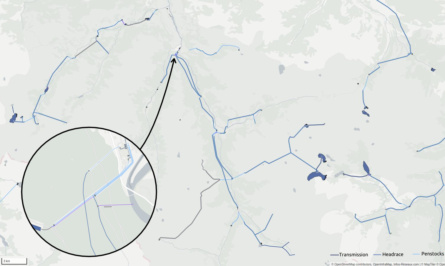
Water management and power infrastructure had made me busy here for years. Hydropower infrastructure intersects them both.
A new wikipage has been published about that (and waits to be improved) : osm.wiki/Power_generation/Hydropower
It’s not only about dams, power houses but about waterways as well, and OSM tagging model has been continuously developing to describe this. Water management will be more and more important in coming years to tackle droughts and fair water access challenges. Constantly seeking new ways to produce power and store water require accurate data and objectivity.
As hydro mapping and tagging improves on every continent, a more robust documentation on that particular topic may now be useful.
You will probably read it as a complement of existing waterways and water management pages.