pwbriggs's Comments
| Changeset | When | Comment |
|---|---|---|
| 177460274 | This edit looks good, thanks for the contribution! |
|
| 177460238 | Thanks for your contribution. I have some notes on this edit: * It looks like you decreased the precision of 126th St Ct E (way/225581519/history/5) Why? ESRI imagery licensed for use in OSM suggests that the way it was mapped was correct. * oneway=no doesn't add any information. Roads are by default assumed to be two-way. * A minor-road stop sign (highway=stop + stop=minor, you added 2 of these) should be located at the stop line on the minor road(s). Otherwise data consumers don't know which road the stop sign applies to. * The lanes=* tag specifies the total number of lanes, both directions. lanes=1 could still be correct on 126th St Ct E, but be aware that this implies vehicles cannot pass each other in opposite directions, or would have to do so very slowly (which, again, *is* in fact the case on many residential roads) * I can't find any documentation for crossing=stop_sign. the crossing=* tag is intended for describing pedestrian crossings. A highway=stop could be mapped here separately if there is a stop sign. In light of these notes, especially the removed precision on 126th St Ct, I've reverted this changeset. Please don't take offense at that; I know that OpenStreetMap has quite the learning curve. Please reach out with any questions or comments. Another helpful resource to learn more about OpenStreetMap is the OSM US Slack available at https://slack.openstreetmap.us/. There are lots of us on there happy to discuss questions. Thanks again for the contribution, and welcome to OSM! |
|
| 177537475 | Actually, bus relations look fine. |
|
| 177398120 | oh okay, nvm about manufacturer tags then. thanks |
|
| 177398120 | Oh, huh. Well, let me add the manufacturer tags back then to indicate Flock. I was not aware Flock made cameras in this form-factor, so thanks for sharing! Happy mapping! |
|
| 177398296 | I don't see a camera at the exact spot you indicated, however, there is a school zone speeding ticket ALPR about 50ft north of the lcoation you indicated, is that the camera you meant? As far as I'm aware, Flock Safety doesn't make those. Please confirm. |
|
| 177398120 | Is this really a Flock ALPR? As far as I can tell, it's just your average City of Auburn traffic camera--look at "304th Roundabout Cam" on https://gis.auburnwa.gov/trafficphotowall/prod/index.html Please be careful when adding these cameras--not every camera is a license plate reader, and not all cameras or ALPRs are made by Flock. If you see a camera or surveillance device that you can't correctly add in DeFlock (I don't know what the app's interface is like, but I imagine it's limited), please open a note on OpenStreetMap instead so other local mappers can add it correctly. Thanks for the contributions-- we appreciate it, and I just want to make sure the data remains high-quality! Please let me know with any questions, or more info about this particular camera. For now, I'll edit this to be a City of Auburn traffic cam. Thanks! |
|
| 170807581 | For transparency, linking to OSMUS Slack thread regarding these changes: https://osmus.slack.com/archives/CCJ2P6KCH/p1768535533160899. Thanks! |
|
| 177270972 | Thanks for adding this! |
|
| 177113963 | Thanks for responding, @Brian's%20Automotive%20&%20Performance You didn't mention Quality Auto Sales-- is that one gone? |
|
| 177207846 | This looks good to me, thanks! My main note is that explicitly tagging roads as not one-way (oneway=no) is unnecessary-- it's assumed by nature of this being tagged as a roadway that it's two-way.
|
|
| 177247784 | Thank you for the contribution. I changed this to building=garage because it looks from aerial imagery like there is a garage building here. Tags can be confusing, but let me know if this was intentional! Thanks again for the contribution, and welcome to OpenStreetMap! If you have any questions, feel free to ask here or on https://slack.openstreetmap.us/ |
|
| 177113335 | FYI this was removed by another contributor in changeset/177243135. I'm not familiar with this area, but is this camera not in fact here? |
|
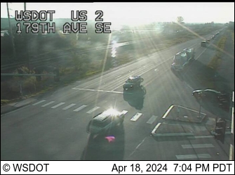
| 177235819 | Hi, thanks for the contribution! I don't see any Flock cameras at this location based on 2021 street-level imagery. The only camera I can see is mounted on the pole at the northeast corner of this intersection, which is the WSDOT US2 mile 13.9 traffic camera (https://images.wsdot.wa.gov/nw/002vc01390.jpg, see https://wsdot.com/Travel/Real-time/Map/). WSDOT traffic cameras are neither ALPRs nor manufactured by Flock. Could you please confirm that there is a license plate reader at this place? I'll add the washdot camera separately because this doesn't seem to be it. |
|
| 177209335 | re: your source tag -- please be careful not to include too much personal info. Otherwise, these edits look good. Thanks for the work on this area! |
|
| 177113963 | Okay, I opened a note. |
|
| 177191625 | Regarding your edit specifically, you mentioned that this is a staircase. I updated this area to change that into a staircase, could you check to see if it looks correct now? Thanks! |
|
| 177191625 | Thank you for the contribution. Please note that it is prohibited to use Google Maps or Google Streetview at all when contributing to OpenStreetMap: see osm.wiki/Legal_FAQ#Contributing You indicated that you made this edit based on local knowledge, so I am assuming that you are only linking those streetview images for reference. That's fine but discouraged because essentially OpenStreetMap wants there to be no question about copyright infringement. FYI, there is some Bing street level imagery licensed for use in OSM. It's not as good or new as Google's imagery, but it's what we've got. To access it, you can hit the "layers" button on the right sidebar in the editor and check the apropriate boxes (there are a few other street-level imagery providers you can also enable, but Bing usually has by far the best coverage and quality in urban areas). Thank you for understanding: we want to ensure that it's completely obvious that OSM's data is 100% legal, which means we try to exercise lots of caution. But thanks for the contribution, we really appreciate this. It's the community of local people carefully adding details like this about the places they know best that, in my opinion, makes OpenStreetMap such a great project. Thanks for being a part of this :) |
|
| 177113963 | @Glassman are you saying that Brian's Auto might not be located here? Or that it probably replaced Quality Auto? |
|
| 177134240 | Thanks. I fixed the tags you used to be in correct, machine-readable format. |