OpenStreetMap
jmapb's Comments
| Changeset | When | Comment |
|---|---|---|
| 179409052 | Hello fellow mapper! Regarding footway=crossing ways 909331146, 909331156, 908944880, 908941864, 908940988 -- indeed it's been my understanding that a crossing:markings= tag means that crossing:marked= is unnecessary. Not a fan of redundant tagging in general, both for brevity's sake and to avoid data conflicts when tag values get out of sync. crossing:markings= is a well-conceived tag and popular enough at this point that any current software that cares about crossings should know about it. Maybe the documentation currently recommends otherwise? Feel free to add tags as you see fit. I don't edit-war on the map or on the wiki. Regarding footway=crossing ways 1268825926 and 1268825927, mea culpa, looks like I've been using =uncontrolled wrong -- at least since the documentation page was edited on 2022-09-26 to claim that crossing markings are required for an "uncontrolled" crossing. News to me, but this has stayed in the wiki for 4 years. So even though it sounds illogical I'm not inclined to dispute it. I've removed =uncontrolled from these 2 ways. Happy mapping, J |
|
| 171044962 | On second thought tagging them with an ID (ref:nycgreenthumb or something like that) would be more useful. Maybe the "gardensid" code from https://data.cityofnewyork.us/dataset/GreenThumb-Garden-Info/p78i-pat6/about_data |
|
| 171044962 | These signs indicate membership in the GreenThumb program, not that the gardens are actually city-operated properties. They do resemble the signs the Parks Dept uses for its own properties so it's bound to cause some confusion. Being in the GreenThumb network does not indicate city ownership or operation. For example, the Suffolk Street Garden (way/207573814) is correctly tagged with operator=New York Restoration Project, but it's also a GreenThumb garden. New York Restoration Project operates several gardens around the city, but most are run by local neighborhood gardening clubs. I can't promise there are *zero* city-operated community gardens (haven't surveyed them all!) but it shouldn't be presumed from signs featuring the Parks Dept logo. If we want a tag that indicates membership in the GreenThumb program, I guess I'd suggest network=GreenThumb? (Or =NYC Parks GreenThumb to be a little more specific?) |
|
| 171044962 | Hi, what's the source for these operator tags? I'm particularly concerned with the community gardens, which are generally operated by local gardening clubs-- I don't know of any that are operated by the city. |
|
| 166679054 | Partially reverted in changeset/183746600 -- this changeset added invalid construction based on outdated imagery. In particular, way/1389210257 was added where Bing aerial shows construction beginning for a new bridge over the Esopus. The bridge was finished and mapped years ago, but it was incorrectly realigned in changeset/165022889 shortly before this changeset, which obviously led to some confusion here. When mapping without local knowledge, please pay attention to how the date of the aerial imagery compares to the date of recent edits. Bing is pretty old around here. Feel free to leave a map note or contact a local mapper in cases of ambiguity. Thanks, jmapb |
|
| 165022889 | Reverted in changeset/183746600 -- this changeset introduced incorrect road geometry based on outdated imagery. In particular, the bridge way/964074932 was moved to align with imagery of a previous, now-demolished bridge. When mapping without local knowledge, please pay attention to how the date of the aerial imagery compares to the date of recent edits. Bing aerial is pretty old around here. Feel free to leave a map note or contact a local mapper in cases of ambiguity. Thanks, jmapb |
|
| 182763423 | (see comments at changeset/138391273 and changeset/182755922) |
|
| 138391273 | (discussion continued at changeset/182755922) |
|
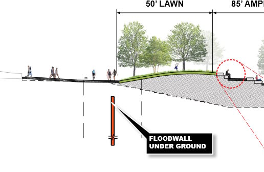
| 182755922 | (My changes were undone in way/1515002168, discussion here is continued from changeset/138391273) Compare man_made=dyke to this picture from page 32 of the linked pdf:
Maybe changing the tag would help, as well as tagging layer=-1 or location=underground. Regardless of the tagging choices, though, I think this approximate underground wall fails OSM's basic verifiability criteria, since a mapper on the ground can't confirm or improve it. (The inclusion of a check_date is especially odd -- nothing was checked!) I consider it to be part of the park's foundations, not a separate feature. |
|
| 138391273 | Finally, I'm really not sure these various flood control measures really merit a relation at all. IMO East Side Coastal Resiliency is a government initiative, not a geographic feature. But I left relation/16079502 alone, just deleted these two members. |
|
| 138391273 | Sometimes *is* helpful to map currently nonexistent features, if their geometry is actually known. In these cases it's best to use a lifecycle prefix (osm.wiki/Lifecycle_prefix) to ensure the map renderers and other data consumers won't see these features as current real data. Relying on tags like proposed= and start_date= isn't advisable, because you can't assume that data consumers will check for those. |
|
| 138391273 | Hi, I've removed the dykes way/1188974503 and way/1188974504 -- based on survey and imagery, these ways were running right through active parkland. Perhaps the plans changed, if so, this is a good example of why mapping things before they exist can be problematic. |
|
| 177786559 | That said, if the address is 570 5th Avenue, the architect really should have gone for 570 feet! Or 570.5 even! Total missed opportunity. |
|
| 177786559 | Don't stress out! ;) A fundamental principle of OSM is that what's on the map should match what's on the ground. Until there's an under-construction building that can be observed, mapping building=construction is premature. (building=construction says "the building should have at least the walls of the first floor" -- I think that's fair.) way/1471849035 is now rendering as a building, potentially confusing to anyone using this map for navigation and seeing just a hole in the ground. (The broken ground itself is already covered by the landuse=construction way/480796870.) So I've changed the footprint to proposed:building=yes and added a fixme tag to refine later. As far as the height goes -- 567 feet has three significant figures, so converting to 172.82 adds false precision. 173 would be more appropriate, 172.8 in a pinch because feet are smaller than meters. |
|
| 177786559 | Hi MadCat3D, regarding way/1471849035 -- construction hasn't begun on this building yet. What's your source for the building footprint, and building height accurate to the centimeter? |
|
| 181591272 | Changed this to building=construction -- fence is up but the building is still intact, and the only posted permit is for renovation of open space. I'll keep an eye on it of course. |
|
| 137571845 | Hi Chuckles 2, I've reverted this changeset with changeset/181514568. Bikeability is not a requirement for the highway=path tag. Furthermore, the bikeability of these particular paths is up to interpretation -- there are no restrictions signed or on the website. |
|
| 174440634 | Hi philpennmap, I've reverted this changeset with changeset/177724792 -- there was already an existing relation for Governors Island (relation/2389631). Please see comments on changeset/174440574 thanks, jmapb |
|
| 174440574 | Hi philpennmap, wireguy is correct here -- there was already a relation mapped for Liberty Island (relation/9791559), so there's no need to create a new one. I reverted this changeset with changeset/177701290 and removed the new relation you added (relation/19815770). It looks like you also created duplicate relations for Governors Island (relation/19815779) and Ellis Island (relation/19815764). These have been fixed too. It's a good idea to use OSM's search function and the "query features" function (? symbol on the right of the map) to find what's already mapped, to avoid creating duplicates. And if you think you might have created other duplicates and need help fixing them, please let me know. Thanks, jmapb |
|
| 153480879 | Hi, I removed way/1298676047 in changeset/173253101 |