Zaneo's Comments
| Changeset | When | Comment |
|---|---|---|
| 181494471 | This was a typo/fat finger of tree which auto corrected to tram. I’ve fixed to tree row, thanks for the catch! |
|
| 181577047 | It's a bit strange for shop details that can't be seen from aerial images. |
|
| 181577047 | The source was listed as: Bing; OpenStreetMap Carto (Standard) That's why I asked. Happy to hear that it's not automated! Thanks for your contributions. |
|
| 181577047 | How did you map this from Bing and Carto overlay? Is this an automated edit? |
|
| 180710544 | Thanks for improving this area! |
|
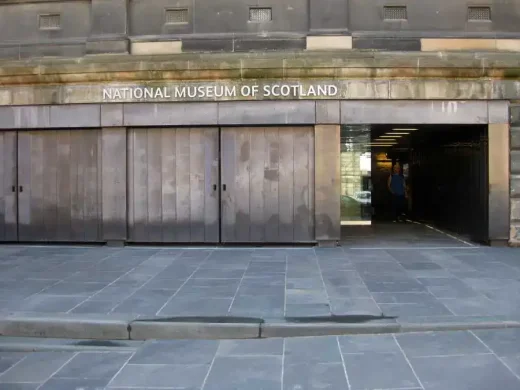
| 180081710 | The current version is an over simplification I feel, that sliver I cut out cannot be navigated with a wheelchair. For me the pedestrian area represents an area that can be navigated without passing though steps. Had it been a ramp that would be a different story. What I had added can be seen here: https://dynamic-media-cdn.tripadvisor.com/media/photo-o/32/a5/2a/71/cool.jpg?w=1000&h=-1&s=1 Shown better here: https://files.nms.ac.uk/production/Documents/National-Museum-of-Scotland/2024/Visual-Story-Main-Entrance-Updated-10-May-2024.pdf?dm=1719843440 Those white lines are the step edge markers. Not yet added is the right side entrance:
Note these images are just reference we should not use them to add the feature. Which has a step up and therefore a disconnect from the pedestrian way. |
|
| 180063425 | I had to walk along through the parking lot, I guess it would be best if somebody could confirm the sign. Unfortunately I didn't think to take a picture. |
|
| 180103384 | Added shrubbery tags |
|
| 180063425 | I visited this location and that part is for the service bus that comes down the hill. There was explicitly a no entry sign. |
|
| 180081710 | Each stair extends a little further to the right until it leave a small area. The new gap on the right is where another large staircase is. |
|
| 180081710 | There's a staircase that cuts into the pedestrian way. |
|
| 168582544 | Thanks for fixing! However about: 35.5230808/139.6894337 I disagree, there is clearly a baseball field. I think it's okay to have multi and overlapped but if we can recognize a pitch outline we can add it. We can clearly see the baseball shaped fence and base lines at the coordinates I linked. Overall I agree with your modifications to my changeset though! Let's work together. |
|
| 159044359 | Why is this named Ragas, and another nearby edit named Sagar? |
|
| 159044393 | Sorry wrong changeset. This comment was meant for: 159044438 |
|
| 159044438 | Does this really exist? It's not present on Bing imagery, also looking at the nearby mapillary imagery I can't see it. |
|
| 159044393 | Does this really exist? It's not present on Bing imagery, also looking at the nearby mapillary imagery I can't see it. |
|
| 159044292 | Is this building really called example? |
|
| 158481267 | Sounds good, thanks for sharing! |
|
| 158481267 | Are the names really displayed like that or is the branch? e.g. name:ja=セブンイレブン 西千葉駅南口店
|
|
| 148578808 | Is the "Lyft-owned aerial imagery" compatible with OSM license? |