Udarian's Comments
| Changeset | When | Comment |
|---|---|---|
| 185091643 | next time please leave a changeset comment describing what you actually did in the changeset. Happy mapping,
|
|
| 185048694 | please do not use short codes in names for roads, "South Exuma Road" would be the correct name in this case, not "S Exuma Road". happy mapping,
|
|
| 185050753 | two things, fist of all are sure that way way/1064456119 is a track, because I can't find any evidence of this, I could see it being "lane" or "shared_lane". Please review this based on the definitions on the wiki cycleway=*#Common_values . Happy mapping,
|
|
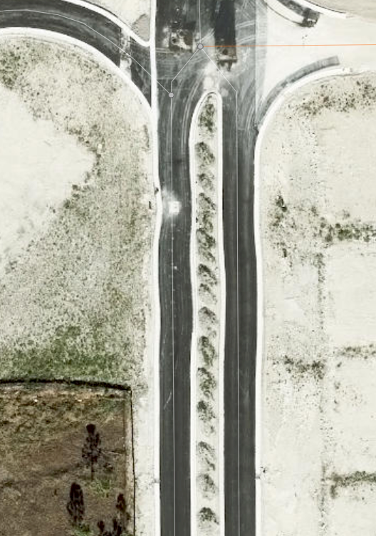
| 184932784 | are you sure that there is no curve on way way/1444622491 as on the latest imagery there is, screenshot of this at https://raw.githubusercontent.com/Udarthegreat/public-sources/refs/heads/main/other/Screenshot%202026-07-01%20153359.png . happy mapping,
|
|
| 184874874 | the position of this dentists office is highly unlikely as it is in the middle of the US 27 middle island (between the carriageways), please update its position to where it is located in the real world. happy mapping,
|
|
| 184816879 | This vertex was already tagged as a traffic signal which from what I can tell still exists, if you want to add an ALPR at this intersection please add a new node at the actual location of the ALPR, not in the middle of the road where there is already something that is already mapped. Happy mapping,
|
|
| 184436956 | addr:street should have the full expanded name not the shortened one, so in this case Northwest 7th Avenue instead of NW 7th Ave happy mapping,
|
|
| 184408648 | looking at this ALPR on the latest aerial imagery in iD it seems to be within the road area, being positioned like this is highly unlikely so please double check the position of this ALPR and fix it. Happy mapping,
|
|
| 184301502 | objects in OSM need a tag that indicates what the object is, sadly from my knowledge there is no tags for a "Sales Gallery" for residential development and thus should not be mapped. The crossing added in this changeset is also unlikely to be correct as it was placed in the middle of a building. Also from my understanding all vertices of a power line should have a power pole tagged and there did not seem to be any power poles at the location of the vertex you added to the power line. There are ways to map landuse, if you want help with that feel free to reach out and I can help. Happy mapping,
|
|
| 184301309 | as mentioned above the city of Miami still exists |
|
| 184301309 | why did you delete the city of Miami?? Happy mapping,
|
|
| 184184848 | also please do not add crossing=marked in Miami Dade, it should be crossing=unmarked (due to legacy reasons) crossing=uncontrolled and crossing=traffic_signals. |
|
| 184184848 | In Miami Dade unless the sidewalk empties directly into the road (is a strait line out of the road) crossing ways should not touch sidewalk centerlines. Basically the min standard for geometry is PWG silver tier osm.wiki/Foundation/Local_Chapters/United_States/Pedestrian_Working_Group/Guide . Happy mapping,
|
|
| 184150449 | USPS would be more of a short_name=*, but that short code is already tagged under operator:short=*. That branch seems correct to me. |
|
| 184150449 | I have also been sent the following link https://slack.openstreetmap.us/ |
|
| 184150449 | https://openstreetmap.us/get-involved/slack/ has a "Sign Up" button, does that work for you? |
|
| 184150449 | from more info see https://osmus.slack.com/archives/C2VJAJCS0/p1781558484728769 |
|
| 184150449 | Unless the name of a place is actually signed under the general form of "Brand - location" (what you used for the Norland Post Office) it should just be the name of the place, aka what is signed is the name. If you want to encode what the brand and branches are there are tags specifically for that (`brand=*` and `branch=*` respectively). Basically the name is supposed to reflect the official name of the object being represented. Happy mapping,
|
|
| 183993596 | the only cameras I see are off to the side of the sidewalk inside of the verge and not in the road area, I do not see any inside of the road area, even attached to the traffic light. That just further reinforces to me that the position of this ALPR is incorrect. Happy mapping,
|
|
| 183993596 | looking at this ALPR on various aerial imagery in iD it seems to be within the road area, being positioned like this is highly unlikely so please double check the position of this ALPR and fix it. Happy mapping,
|