GOwin's Comments
| Changeset | When | Comment |
|---|---|---|
| 182119233 | Hi there, and welcome to OpenStreetMap! 🎉 We noticed you're working with some boundary data, and we wanted to reach out as a friendly heads-up. It looks like these boundaries might be coming from the Philippine Statistical Authority, and we want to make sure we're respecting their ownership and getting the right permissions before bringing them into OSM. This is really important to us! The good news is that we've got resources to help! If you'd like to learn more about how imports and licensing work in OpenStreetMap, we're happy to walk you through it. It's easier than you might think. Here are a couple of great places to start: FAQ on PH data imports: osm.org/wiki/Philippines/FAQs_for_PH_data
Our local communities in the Philippines are super helpful and genuinely want to support you—whether that's answering questions, discussing the best way to handle this data, or finding alternative sources that are already open for use. Just so you know, imports that haven't been discussed with the community or come from unclear sources do tend to get removed down the line. We do this to keep OSM data free and available for everyone to use without restrictions. But don't worry—we can absolutely figure this out together! Feel free to reach out with any questions. We're here to help. 😊 |
|
| 182118507 | Hi there, and welcome to OpenStreetMap! 🎉 We noticed you're working with some boundary data, and we wanted to reach out as a friendly heads-up. It looks like these boundaries might be coming from the Philippine Statistical Authority, and we want to make sure we're respecting their ownership and getting the right permissions before bringing them into OSM. This is really important to us! The good news is that we've got resources to help! If you'd like to learn more about how imports and licensing work in OpenStreetMap, we're happy to walk you through it. It's easier than you might think. Here are a couple of great places to start: FAQ on PH data imports: osm.org/wiki/Philippines/FAQs_for_PH_data
Our local communities in the Philippines are super helpful and genuinely want to support you—whether that's answering questions, discussing the best way to handle this data, or finding alternative sources that are already open for use. Just so you know, imports that haven't been discussed with the community or come from unclear sources do tend to get removed down the line. We do this to keep OSM data free and available for everyone to use without restrictions. But don't worry—we can absolutely figure this out together! Feel free to reach out with any questions. We're here to help. 😊 |
|
| 182118554 | Hi there, and welcome to OpenStreetMap! 🎉 We noticed you're working with some boundary data, and we wanted to reach out as a friendly heads-up. It looks like these boundaries might be coming from the Philippine Statistical Authority, and we want to make sure we're respecting their ownership and licensing, getting the right permissions before bringing them into OSM. This is really important to us! The good news is that we've got resources to help! If you'd like to learn more about how imports and licensing work in OpenStreetMap, we're happy to walk you through it. It's easier than you might think. Here are a couple of great places to start: FAQ on PH data imports: osm.org/wiki/Philippines/FAQs\_for\_PH\_data
Our local communities in the Philippines are super helpful and genuinely want to support users' initiatives —whether that's answering questions, discussing the best way to handle this data, or finding alternative sources that are already open for use. Just so you know, imports that haven't been discussed with the community or come from unclear sources do tend to get removed down the line. We do this to keep OSM data free and available for everyone to use without restrictions. But don't worry—we can absolutely figure this out together! Feel free to reach out with any questions. We're here to help. 😊 |
|
| 182118454 | Hi there, and welcome to OpenStreetMap! 🎉 We noticed you're working with some boundary data, and we wanted to reach out as a friendly heads-up. It looks like these boundaries might be coming from the Philippine Statistical Authority, and we want to make sure we're respecting their ownership and licensing, getting the right permissions before bringing them into OSM. This is really important to us! The good news is that we've got resources to help! If you'd like to learn more about how imports and licensing work in OpenStreetMap, we're happy to walk you through it. It's easier than you might think. Here are a couple of great places to start: FAQ on PH data imports: osm.org/wiki/Philippines/FAQs\_for\_PH\_data
Our local communities in the Philippines are super helpful and genuinely want to support users' initiatives —whether that's answering questions, discussing the best way to handle this data, or finding alternative sources that are already open for use. Just so you know, imports that haven't been discussed with the community or come from unclear sources do tend to get removed down the line. We do this to keep OSM data free and available for everyone to use without restrictions. But don't worry—we can absolutely figure this out together! Feel free to reach out with any questions. We're here to help. 😊 |
|
| 182119202 | Hi there, and welcome to OpenStreetMap! 🎉 We noticed you're working with some boundary data, and we wanted to reach out as a friendly heads-up. It looks like these boundaries might be coming from the Philippine Statistical Authority, and we want to make sure we're respecting their ownership and licensing, getting the right permissions before bringing them into OSM. This is really important to us! The good news is that we've got resources to help! If you'd like to learn more about how imports and licensing work in OpenStreetMap, we're happy to walk you through it. It's easier than you might think. Here are a couple of great places to start: FAQ on PH data imports: osm.org/wiki/Philippines/FAQs\_for\_PH\_data
Our local communities in the Philippines are super helpful and genuinely want to support users' initiatives —whether that's answering questions, discussing the best way to handle this data, or finding alternative sources that are already open for use. Just so you know, imports that haven't been discussed with the community or come from unclear sources do tend to get removed down the line. We do this to keep OSM data free and available for everyone to use without restrictions. But don't worry—we can absolutely figure this out together! Feel free to reach out with any questions. We're here to help. 😊 |
|
| 182119251 | Hi there, and welcome to OpenStreetMap! 🎉 We noticed you're working with some boundary data, and we wanted to reach out as a friendly heads-up. It looks like these boundaries might be coming from the Philippine Statistical Authority, and we want to make sure we're respecting their ownership and licensing, getting the right permissions before bringing them into OSM. This is really important to us! The good news is that we've got resources to help! If you'd like to learn more about how imports and licensing work in OpenStreetMap, we're happy to walk you through it. It's easier than you might think. Here are a couple of great places to start: FAQ on PH data imports: osm.org/wiki/Philippines/FAQs\_for\_PH\_data
Our local communities in the Philippines are super helpful and genuinely want to support users' initiatives —whether that's answering questions, discussing the best way to handle this data, or finding alternative sources that are already open for use. Just so you know, imports that haven't been discussed with the community or come from unclear sources do tend to get removed down the line. We do this to keep OSM data free and available for everyone to use without restrictions. But don't worry—we can absolutely figure this out together! Feel free to reach out with any questions. We're here to help. 😊 |
|
| 182119254 | Hi there, and welcome to OpenStreetMap! 🎉 We noticed you're working with some boundary data, and we wanted to reach out as a friendly heads-up. It looks like these boundaries might be coming from the Philippine Statistical Authority, and we want to make sure we're respecting their ownership and licensing, getting the right permissions before bringing them into OSM. This is really important to us! The good news is that we've got resources to help! If you'd like to learn more about how imports and licensing work in OpenStreetMap, we're happy to walk you through it. It's easier than you might think. Here are a couple of great places to start: FAQ on PH data imports: osm.org/wiki/Philippines/FAQs\_for\_PH\_data
Our local communities in the Philippines are super helpful and genuinely want to support users' initiatives —whether that's answering questions, discussing the best way to handle this data, or finding alternative sources that are already open for use. Just so you know, imports that haven't been discussed with the community or come from unclear sources do tend to get removed down the line. We do this to keep OSM data free and available for everyone to use without restrictions. But don't worry—we can absolutely figure this out together! Feel free to reach out with any questions. We're here to help. 😊 |
|
| 182196627 | Eugene, please reconsider NOT reusing the waterway element for this boundary relation. Maning and I are slowly going to through these types of relations, and a separate way is much more ideal. |
|
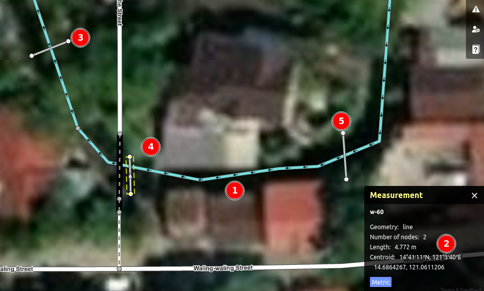
| 181436710 | Hello @msjejdr. Thanks for improving the geometry of these waterways. They also appear to be between 5-7 meters wide, and wateray=river seems to be a more appropriate tag. https://i.postimg.cc/htbqhH6Y/image.png RapiD has a measurement panel (2) you can use, to help approximate widths , by drawing temporary line segment for measuring distance (3,4,5), or an existing line (1)
|
|
| 181308784 | Hello! Maybe the FAQ for waterway mapping can help you with this: https://hackmd.io/@osmph/H1ZB1J9Tle#How-do-I-distinguish-between-a-river-and-a-stream
|
|
| 181309323 | Using RapiD or iD, you can enable the measurement panel using the shortcut: "Ctrl+Shift+M", or go to Map Data , then tick the checkbox for "Measurement Panel" under the Data Layer section.
|
|
| 181309006 | This waterway is too wide to be a stream. Remember the OSM convention: if an able-bodied person should can jump across a waterway, it's a stream, wider than that, it's a stream. Based on imagery, most segments of this waterway is more than 3m wide.
|
|
| 179978455 | The segment with culverts are not likely to follow the stream geometry, and are usually just that part going under a road.
|
|
| 179978413 | Looks good!
|
|
| 179276042 | Your edits are helping create better waterway data in the country. Thanks for chasing more waterways. 🌊 When you're trying to decide between tagging a feature as a river, or a stream, remember that OSM's rule of thumb is if an able-bodied person couldn't jump across it, it's a river. See our FAQ: https://hackmd.io/r_OGCQChQVW2ivytc1cg9A#How-do-I-distinguish-between-a-river-and-a-stream Keep it up!
|
|
| 179249054 | Hi there! Your edits are valuable, thanks for helping us chase more waterways 🌊 in the country.
|
|
| 177255273 | Good job! 👋Thanks for helping improve the map. Next time, try to add phone numbers in the international format (i.e. +63xxxxxxxxxx), since it cannot be assumed that callers are always local. |
|
| 177092594 | That's awesome! Please don't forget to add the "Street" suffix, if applicable. |
|
| 175650633 | Your observation is correct and noted. Thanks. |