 OpenStreetMap

Hello, I am Brazil Singh, a computer science undergraduate from Eastern University Bangladesh. I’m a an Wordpress webdeveloper. I am also an Editior of Youthmappers at Eastern University. Today I edited the osm. Location was Eastern University building’s Tea Stall. Seriously I enjoyed a lot by contribuiting here.
Users' Diaries
Recent diary entries

OSMCha is almost eight years old now. A project that I started in my spare time to try to solve some data quality issues of the Brazilian OpenStreetMap community, grew up, became my job for some years, and is now an essential component of the OSM software ecosystem.
Since the beginning, Mapbox has been a crucial partner for OSMCha. They believed in the idea right after I presented it at a State of the Map LatAm conference. In 2015, they had around 10 people doing quality assurance in OSM data and there wasn’t a clear workflow on how to keep track of the changes in OSM. The main idea behind OSMCha was to register all changesets in a database, run some automatic checks to flag possible quality issues, and make the changesets searchable. That solution seemed interesting to the Mapbox team, so they started using it right away, improved the tool, and kept it running during all those years.
However, since June 2021, OSMCha is running without constant maintenance, and only one new feature was added, with the sponsorship of Wikimedia Italia. The lack of a team responsible for monitoring and maintaining the infrastructure caused a few days of downtime.
Now it’s time for a new phase in the OSMCha history! OpenStreetMap US has just accepted it as a charter project. This partnership will provide the structure to raise funds for development and hosting, and will also open the possibility for the entire OSM community to influence the future of OSMCha.
In collaboration with the OSM community, I believe we will be able to keep OSMCha running and provide yet more value for the users.
Soon, we will announce how you can engage in the OSMCha community meetings. Right now you can join the #osmcha channel in the OSM US Slack and continue reporting issues in the GitHub repository.
We also welcome companies and non-profit organizations that are interested in supporting OSMCha. Write to wille AT developmentseed.org if you want to have a chat about how you can collaborate with us.
Posted by نصرقائداحمدالهلالي on 10 March 2023 in Arabic (العربية).
Last updated on 21 August 2025.

قرية ضريبة العرش. هي إحدى قرى الجمهورية اليمنية، وتتبع جغرافيا محافظة البيضاء وادريا مديرية العرش منطقة رداع. ويبلغ عدد سكانها 2363 نسمة حسب التعداد السكاني عام 2004، وتقع في الجنوب الغربي لمديرية العرش وتبعد عن مدينة رداع 9كم ومساحتها الجغرافية 21كم مربع. تقع شمال مدينة رداع، وتجاورها قرى [[قرن الأسد ]] و[[ماور]]، مما يمنحها موقعًا متوسطًا بين المعالم الجغرافية والتاريخية للمنطقة.
== المقدمة == بين الجبال الصامتة التي تروي الحكايات، وعلى سفوح الزمن المتجذر، تقف قرية ‘'’ضريبة العرش’’’ شامخةً بهويتها وتراثها في مديرية العرش بمحافظة البيضاء. ليست مجرد تجمع سكني، بل ذاكرة حيّة تختزل أهازيج الماضي وهمسات الجغرافيا. هنا، في وديان خصبة وأعالي الجبال، تنسج ضريبة العرش حكاياتها الخاصة؛ حيث يروي [[جبل مرغم علي]] و[[قلعة حمة جريد]] و[[غيل القطارة]] قصة قريةٍ تتنفس الأصالة، وتزهر بالذاكرة.
== الجغرافيا والطبيعة == تمتاز ضريبة العرش بتضاريس جبلية ووديان زراعية، وتحتضن مجموعة من المعالم البارزة، من بينها: * ‘'’جبل مرغم علي’’’: معلم طبيعي بارز يُعد نقطة مراقبة وموقع حماية لقلعة الملك الحميري شمر يهرعش . * ‘'’غيل القطارة’’’: مورد مائي ارتبط بعادات اجتماعية وموسمية مثل الحصاد والاستبشار الزراعي. * ‘'’قلعة حمة جريد الأثرية’’’: أطلال تاريخية على قمة جبلية، تشير إلى وجود مدينة قديمة عمرها آلاف السنين.
== السكان والأنشطة == يعيش في القرية سكان ينتمون لأسر قَبَلية مترابطة. يعتمد سكانها على الزراعة، وتربية المواشي. تنتشر المجالس الشعبية التي تُستخدم لتبادل الروايات وحل النزاعات.
’'’إلى قلب قرية ضريبة العرش’’’ هو مسار توثيقي داخل القرية، يهدف إلى تسليط الضوء على أبرز معالمها من خلال سرد مرتب يتتبع العلاقة بين الإنسان والمكان. تُمارس في قرية ضريبة مجموعة من العادات والتقاليد الاجتماعية التي تُعبر عن الهوية الثقافية المحلية، من أبرزها:
- ’'’البراع التراثية’’’: رقصة جماعية تؤدى في الأعراس ومواسم الحصاد، وتتخللها أبيات شعبية تمجد الأرض والانتماء.
- ’'’مراسم الزواج التقليدي’’’: تبدأ بمسير جماعي من المجلس الشعبي إلى بيت العروس، وتُرافقها الزوامل الشعبية .

imar yolları haritalarda gözükmüyor


Unique Mappers Team, Nigeria organized a training session to commemorate the International Women’s Day. Attendees of the program were trained on Digital skills. I was privileged to deliver a lecture on Search Engine Optimisation and Search Engine Marketing as tools of Digital Marketing. The program was enlightening and motivating, as women were reminded that their dreams are valid, and we could be anything we’ve set our hearts to be.

It was indeed a great privilege to be among the 28 selected interns from the 1008 applications received by HOT from 81 countries. I must say, spending October to December 2022 with the HOT trainers and other resource persons in and around the world of open mapping was an experience worth the time and effort.
Post HOT Data Quality Internship program, I can confidently say I am a better mapper than I was before. But being a better mapper alone was not the aim of the DQI but rather how the information acquired will be shared and passed on from person to person so that together quality data will be created in the open mapping community.
In view of this, I have taken it upon myself to visit other local mapping communities in Ghana starting from UCC Youthmappers to share this piece of knowledge with them.
It has been a wonderful journey so far, and i hope to continue and make it much better!

We had a meeting with Mr. Victor Sunday. On the establishment of mapathon centres.
It was a privilege to be one of the Panelists of the IWD hosted by the HOT, North and West Africa Hub. Theme: “Safe Spaces for Women”. It was insightful. English and French were used as a mode of communication and I like that. Teg-Wende and Carter agreed that the submission is being taken note of and that women and girls will be given more attention.
Introduction
Hello, I am Aarya Ahjolia, a computer science undergraduate from Nirma University, Gujarat, India. I’m a passionate developer who loves solving problems.
GSoC’23 Project: Improving Valhalla’s Web App (ReactJS)
Since I’m proficient in ReactJS and have the knowledge of the code base of Valhalla Web app, I love this project to share my time with for Summer’23.
I’ll be updating my entire journey of GSoC’23 and give weekly updates in upcoming diaries.
Thanks for reading!
Posted by Pieter Vander Vennet on 9 March 2023 in English.
Last updated on 11 March 2023.

This is part two which highlights the results of the OSM user survey. Read part 1 about demographics and identity here
Which thematic maps do people use?
56 people gave insight in their favourite maps, yielding a total of 86 mentions of specific map themes or groups of themes.
The theme with the most mentions -namely 9- was the etymology theme. This is not a big surprise, as there has been a tremendous amount of changes made with Open Etymology-map. Some people mention curiosity for their local environment, others are interested in the link between OpenStreetMap and Wikipedia. It should be noted that nearly everyone who mentioned etymology indicates that they have hundreds of edits.
The second place goes to the waste theme with 8 mentions. I have to be honest, this came as a total surprise to me! At first sight, it is a bit of a boring topic - especially when contrasted with something like etymology. Yet, everyone needs to get rid of some waste every now and then. By the way, this theme was created by @Rlin and I have to admit that this is one of the most polished themes on MapComplete, using a lot of the available functionality. Thank you!
The third places goes to all cycling-related themes (7 mentions of ‘cycling’). Cyclofix had another 5 mentions, resulting in 12 total mentions. This was no surprise either, as cyclofix has been historic driver of many changes made with MapComplete. It is one of the oldest maps on MapComplete, yet it is still popular and is embedded on a few websites.
The third place goes to benches with 7 mentions - another very down-to-earth topic but with lots of value and lots of unmapped features.
Out of the other answers, it is clear that there are various reasons to use MapComplete:
My Home

Ruben Martin and I discuss recent highlights and what’s coming up in the humanitarian open mapping community.
What’s covered this week in brief?
Syria / Turkey earthquake response // Community Working Group mentorship programme // OSM Ethiopia community-led activation // Community research on barriers to women’s participation in OSM // International Women’s Day // Month activites and events // Mappy quote of the week
What’s happened this week?
Syria / Turkey earthquake response: The response to the Turkey Syria earthquake has continued, with more than 8,500 mappers contributing to the data.
The validation of the data is still a heavy task, and the validation team is working so hard to keep up with the volume of mapping. Please be careful with your mapping and make sure the data that you create and they review is as good as it can be! This video from Becky Candy should help you if you are new to mapping.
Also want to congratulate Said for receiving UN Mapper of the Month for his role in coordinating the data response in the days following the earthquake.
Posted by Pieter Vander Vennet on 8 March 2023 in English.
Last updated on 11 March 2023.
MapComplete user census
As you noticed, MapComplete ran a user survey during january. What did it tell us?
The use survey had a few goals, namely:
- discovering what demographies are using MapComplete (and which are missing)
- and discovering what needs and wants are still there
Basic demography
The first question is of course: who did fill out the survey? If we look to the numbers, a clear pattern emerges.
The age distribution looks pretty normal - there is a clear peak around the bucket 30-40, which falls down left and right.
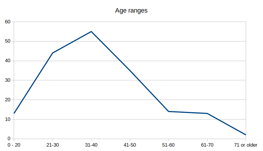
The gender is not as balanced. Unsurprisingly, the majority of respondents is male:
Posted by umbraosmbr on 7 March 2023 in English.

Realization:
UMBRAOSM - Union of Brazilian Openstreetmap Mappers www.umbraosm.com.br https://t.me/grupoumbraosm
BRAZIL - PARINTINS - AMAZONAS - UNMAPPED AREAS IN THE TERRITORY OF THE CITY OF PARINTINS.

link para a task manage da hot: https://tasks.hotosm.org/projects/14395
Paritins is a city in the North of Brazil and is located in the state of Amazonas - Brazil, according to 2020 information, the municipality of parintins (AM) has 115,363 inhabitants and needs mapping throughout its municipal boundary.
Mapping in the city of Parintins/AM - Brazil will be done by beginner and advanced mappers and aims to include buildings, rural roads, rivers, points of interest (shops in general, schools, health clinics, squares) and green areas in the places of kills, thus improving the OSM data.
Many buildings are very close but not really touching. Try to map them as closely as possible without allowing them to connect with each other or the streets.
Posted by kwiatek_123 on 7 March 2023 in English.

Hello! I would like to present a python package written by me.
What’s the point of this package?
This package was created to provide an easy way to create automated scripts and programs that use diff and/or osm api. The main advantage is the classes (data_classes) that provide data of elements (node, way, relation, OsmChange, etc.) in a readable way and the possibility to use them in diff and api without worrying about missing data or dictionaries. You can easily find nodes in diff, add a tag to them and send the corrected version to osm.
More on github
I would love to see your project written using this package!
Orcas

I started drafting this after b-unicycling’s report on her trip to Anglesey as it reminded me that when mapping solar power on the island, I’d noticed a lot of old windmills.

In most of Wales there were abundant sources of water power. So water mills were common before steam engines were available. Many were corn mills, but woollen mills were also common. There was even a tidal mill at Carew.
The only one of these Anglesey windmills I knew about beforehand was the one on Parys Mountain. The stump of the tower is visible from afar. It was used for pumping water out of the copper mines (at one point the largest in the world).
Unique Mappers Team (UMT) organized a meeting for the Keynote speakers, Panelists, Trainers and School Outreach Volunteers on Mar 6, 2023 ,12:30pm to 1:00pm (GMT+01:00) West Africa Standard Time, via the virtual platform -Zoom. The purpose of the meeting was to conclude and finalize on the plans which have being put in place for the International Women’s Day event, which will hold from 8th March - 22nd March, 2023. It was a great avenue to discuss with people of like minds.
Posted by Abigail Itorho on 6 March 2023 in English.
Really excited to have joined the meeting where updates were given by the Local Organizing Committee (LOC) as regards the forthcoming 2023 State of The Map Africa Conference, which is designated to hold in Cameroon. I look forward to the successful accomplishment of the plans in motion and how beautifully the conference would turn out.