 OpenStreetMap

Continents shift at about the same rate as your fingernails grow. Mt. … Ninety percent of Earth’s population lives in the Northern Hemisphere. 4. California has more people than all of Canada. … Australia is wider than the moon.
Users' Diaries
Recent diary entries
In this area there is no home, although the map marks there is.
Posted by GeorgeKarios on 5 December 2022 in English.

the plethora of the edits that am more focused on the time that am writing this exact note are agrotic Rural Roads between the Ayia Napa - Sotira - Paralimni borders, inside the Forest of Agios Antonios and several places near. Η πληθώρα των εξεργασιών που επικεντρώνομε αυτή την στιγμή είναι οι αγροτικοί δρόμοι στα δημοτικά σύνορα της Αγίας Νάπα - Σωτήρας - Παραλιμνίου εντός του Δάσους του Αγίου Αντώνιου και στις τριγύρω περιοχες
- Exact (“micro”) mapping

Introduction
My name is Pragya Pant. I am a geomatics engineer from Nepal.
My OSM Journey
I started mapping in OSM from year 2020. This journey started with mapping just for fun and utilization of my free time. After mapping for few months I started to realize the use and importance of the data I created and how it was impacting the lives of people. Now that I know the value of my contribution I map for a reason.
Interest for mapping
Being a geomatics engineer I have always been fond of mapping. I have been mapping using GIS software and have a knowledge of remote sensing and photogrammetry. I love mapping through field visits interacting to communities so that I can impact them positively. Getting OSM as an open platform I feel lucky to contribute where I use my skills of engineering to impact the communities of any part of the world through remote mapping.
Experience
From the point I realized the importance of OSM data I started mapping for projects that are running in Nepal. My experience in various OSM projects are as follows:
- OSM Mapping and Data Validation of Kailali/Kanchanpur/Doti/Dadeldhura/Rasuwa Districts
- 15 days 15 mapping campaign for mapping unmapped trials and settlements in the remote Dolpa district of Nepal organized by Youth Mappers
- Digitized buildings of Kathmandu Metropolitan City remotely using Open Street Map (OSM)
- Remotely mapped building footprints of different cities of Afghanistan
- Field participant of HOT Microgrant project- “Mapping Chepang community of Nepal”
- Participant in women leadership initiative “She Leads and She Inspires: Women in Leadership Program”- Asia-Pacific Region
- HOT Data Quality Intern for 2022

My 5 years celebration with OpenStreetMap
Down My (OpenStreetMap) Memory lane…
I was just a Geo-informatics and Surveying Polytechnic student at Akanu Ibiam Federal Polytechnic Unwana, Ebonyi State. We used to have practical sessions using Surveying instruments but with time I realized that we are doing the same thing over and over without any data being stored. We would just acquire, use and trash! I then decided to form a team of 4 with my fellow students who I convinced of my vision – we would collect the data, save it and be updating it later to make data available to all and easy to access. We set objectives to achieving our aim and being close with my Head of Department and my lecturers give us access to instruments at any time. We decided to pick every existing feature within the school - it was a difficult experience for months but my passion for data kept me going. At the end of the struggle, we had the data and I then created a unique map for my school which is currently serving as the base map for the school even up to this day. The result got applauded by the department as I made it easy for anyone who may need data for a particular section of the school they can get it easily, saving time and eliminating use and trash. Since that day, I started keeping any data I collected and saving it for reuse. Initially I wanted to pursue Computer Science and Electronic Engineering because of my love for computers and I wanted to change the world as my strength could carry me but alas, I found myself in Geo-informatics and Surveying and completely fell in love with it. More like it was meant for me.
How I met OpenStreetMap
AS
Posted by Gaurav Parajuli on 4 December 2022 in English.

It was a big surprise when I received a mail that mentioned I would be presenting at State of The Map Asia 2022, my first-ever International Conference. The moment became more exciting when Open Mapping Hub - Asia Pacific sponsored us to visit Legazpi, Philippines, and present our work in person. Ever since I started contributing to OpenStreetMap around 5 years ago, this was the first time, I had been a part of such a great event. I thought all the hard work and perseverance had finally paid off.
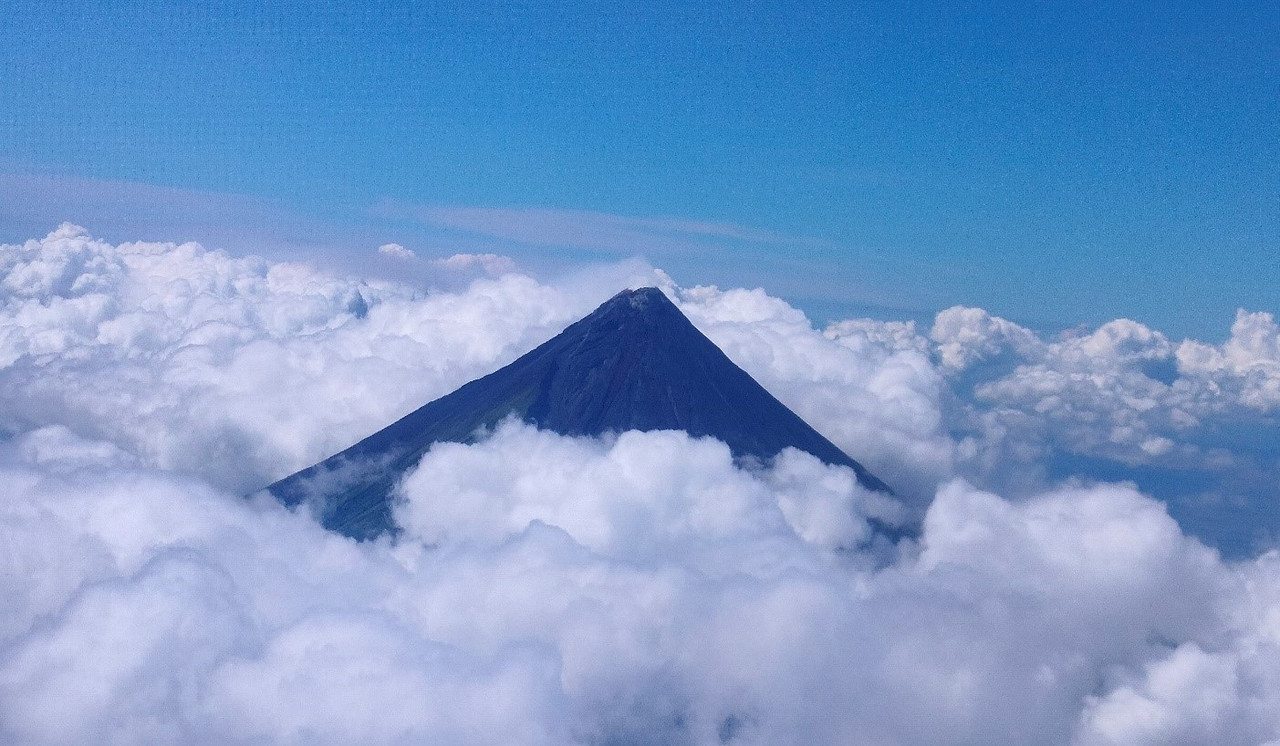
Due to General Election in Nepal, we missed the first two days of Pista NG Mapa but were able to attend all the sessions of SOTM Asia, 2022. Since it was my first international flight, it was a whole new experience and excitement when I reached Legazpi City on 22th Nov. Mount Mayon covered under the cloud was there to welcome us to this beautiful land where we were about to meet OSM enthusiasts around Asia and spend the most exciting five days of my life.
The problem
Historically, the map at map.atownsend.org.uk didn’t change the URL as you moved around, and you had to press a “permalink” button to save the current location. This wasn’t ideal, so I had a look around for alternatives. Helpfully, the Leaflet site has a list of suitable plugins. Of those, leaflet-hash was suggested elsewhere. That seems to be still in use, although it hasn’t been updated for a while. It is spectaculary easy to use, and “does what it does” with no problems.
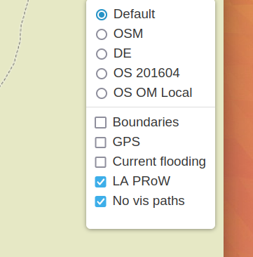
The challenge is that it stores the current location (for example “https://map.atownsend.org.uk/maps/map/map.html#11/54.4900/-3.1098”) but doesn’t store the current layer. That map currently has a choice of 5 base maps (test instances have 6) and 5 overlays:
How to solve this
일기
Posted by CHOOCHATJUMPATHONG on 3 December 2022 in Thai (ไทย).
ChoochatJumpathong 196M.3T.PHANGKKHAENGA.MAENGSAKONNAKHON47000Thailand
Posted by amapanda ᚛ᚐᚋᚐᚅᚇᚐ᚜ 🏳️⚧️ on 3 December 2022 in English.

I started to map in OSM at a mapathon in Prague, Czech Republic, in November 2019. Little did I know then that I was lucky to integrate an already existing, well organized Missing Maps Czech & Slovak community. I joined the Missing Maps project with the Médecins Sans Frontières in January 2020 and since then engaged with many more mapping communities - Missing Maps London, the Missing Maps members, HOT community working group, OSM RDC and OSM Uganda, to name a few.
When we discussed the OSM Diary with @ODULANA_OLUWATOYIN and @JaphetMasunzu, I knew I ought to try as well. When I reflected on topics, community building was a top choice among the six ideas I came up with - I will return to the others at the end. Listed in no particular order, these actions will help: 1. Announce next opportunities We always do that at a wrap-up at the end of a mapathon. This means, that you check in with the community members before what events they are planning before your mapathon. Ideally, you already plan the date and format of the next mapathon. A certain regularity of events is helpful to keep people coming back. Typically, we create a slide that we show, whether online or in-person event, that way people can remember better than if they only heard it.
2. Invite the participants of past mapathons
Eventbrite is a helpful tool to set up and keep track of the registrations. You can download a list of registered participants after the event under the Manage event menu, Dashboard section, and set up an email campaign for the next event under the Marketing section. Make sure to send email invitations to those, who registered for your mapathons in the past 6-12 monts. The click-through rate of the invitation email is the highest, compared to the other communication channels, because these people already know what they are in for!
3. Reach existing supporters through e-newsletter

The other day richlv asked on IRC if there was any OSM-based rendering showing the age of buildings. Although I could think of a couple of examples where people have done this, they did not use OSM data (other than the extremely early work.
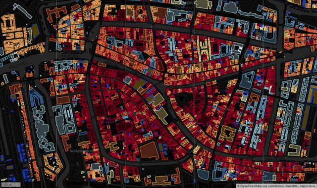
I made use of open data of buildings from Portland Oregon to look at clustering, but the inspiration, and awareness that the data existed, came from a MapBox blog post.
A similar approach was taken by Waag who made use of the BAG open data on buildings for the whole of the The Netherlands.
I wondered if it was possible to use MapCSS styling within OverpassTurbo to create a simple way to achieve the same effect. After a bit of experimentation I was able to do this. I used Dutch localities as test areas as all buildings have been imported from BAG and therefore have start_date tags in a consistent format (“yyyy”). I also looked at other places with some buildings (usually those with a heritage protection) have start_date tags.

A Brief Introduction
My name is Julius Koroma Lahai, a geologist with a keen interest in environmental research and mapping. I’m a graduate of the University of Sierra Leone, Fourah Bay College. I’ve had enough experience with remote sensing and geographic information systems. I started using Open Street Map when I realized that my village, where I spent 14 years, was not visible on maps. My experience with OSM has been amazing, such that I am able to make changes to specific areas that I am very familiar with. In 2020, I was the team leader for the first digital cartographic mapping with Statistics Sierra Leone to delineate enumeration areas ahead of the 2021 Mid-Term Census. I am currently working on the financial inclusion geospatial mapping for the Bank of Sierra Leone under JenMaa Consultants.
Why do I edit and map places with OSM?

INTRODUCTION
My name is Odulana Oluwatoyin Abosede, a Geographer with a keen interest in sustainability. A Graduate of the Department of Geography, University of Lagos, It has been an experience-filled OpenStreetMap journey since I joined in 2019 through the Youthmappers initiative at the University of Lagos. Also, Served as the Youthmappers president of YouthmappersUNILAG in 2021.
MAPPING EXPERIENCE
Some of my mapping experience includes; 1. Sustainableenergy4all Mapathon by NESP 2. United Nations Training in partnership with the University Of Lagos 3. Imagery4SocialGood 4. Humanitarian OpenStreetMap Data Quality Internship 2022 (HOTDQI2022). 5. Some Mapping Projects on OpenStreetMap Asides the openstreetmap contributions, i have had experience going to the field to collect data that can be mapped and also created some maps.
MY INTEREST

ee

We at Unique mappers network Nigeria had Inaugural SoTM Nigeria slated for 1-2 December 2022. It was a lot of fun. We had international grantees from Zimbabwe and Tanzania. We had about 90 participants online. Thanks to HOT unsummit who made the Inaugural SoTM Nigeria unique.
Posted by Caminando Cusco on 1 December 2022 in Spanish (Español).

Reseña de GRD+OSM Latam summit 2022
El evento desarrollado en la ciudad de Lima del 24 al 27 de noviembre permitió conocer a gran parte de la comunidad de OSM Perú, comunidades OSM de América Latina y HOT.
Se destaca que las mesas de dialogo fueron importantes para conocer que se esta haciendo con OSM en el tema de gestión de riesgos y para conocer en mayor medida la región latinoamericana con el desarrollo de mapeos selectivos según las especialidades de los ponentes.
Destaco que los talleres fueron interesantes, sobre porque el evento permitía poder conversar mas ampliamente de los temas expuestos con los ponentes, estas conversaciones permitieron ampliar el tema así como aplicarlo a los intereses particulares de cada participante.
En el tema de las salidas programadas se puede destacar las visitas al COEN y a los sitios arqueológicos de Pachacamac y Caral, en los cuales pudimos desarrollar algunos mapeos sobre todo de elementos expuestos dentro de estos espacios.
Por ultimo destaca que esta reunión permitió crear lazos entre los mapeadores de OSM a nivel nacional generando un entorno de solidaridad con los proyectos ya iniciados y que necesitaban del apoyo de la comunidad OSM para concluir (Proyecto Pumamarka)
Espero que el próximo año podamos reunirnos a nivel nacional de forma mas constante para programar mayores actividades en conjunto como comunidad.
Motivated by OpenStreetMap Poland’s openaedmap.org, I went on a targeted survey of AEDs in Kilkenny. I had added some before, and I always do, when I see one, but this time I put some extra effort in, knocked on doors etc.
According to overpass, I’ve edited 141 AEDs, but some are in areas I’ve never been to, so I don’t know how that happened. Unless I used mapillary…Impossible to remember.
Kilkenny is a small Irish town with a lot of tourism. (They want it to be called a “city”, because they got that status in 1609, but the numbers are telling a different story.) I started off using openaedmap.org on my phone, but then I learned about the Quick Actions on OSMAnd, made myself one for AEDs and used it from then on.
Over the course of two days (3-5 hours in total maybe), I went into most
- hotels (50-50 chance)
- supermarkets (SuperValu and Dunnes good coverage, Lidl not)
- shopping centres (100% with 3 surveyed)
- banks (bad coverage with 2 surveyed, AIB and Permanent TSB)
- some doctors’ offices,
- churches,
- public offices (good coverage)
- major tourist attractions (coverage depends on size and operator)
- social facilities (good coverage)
in an about 1km radius etc. Not only was I able to add about 23 unmapped AEDs, but I also raised awareness about the bad coverage after 6pm, because many businesses close then, and none of the AEDs surveyed during these days are outdoors and publicly accessible. Some people also weren’t aware about the closest AED to them or had outdated information.
When I got into longer chats with people, I also got a chance to mention openaedmap.org, and stickers or cards would have come in handy, but they might find it anyway.
.heif)
I wanna to thank you for the organizer in Pista ng Mapa × State of the Map Asia 2022 that they choose me in Free Travel Granted. I didn’t expect to be choosen in Free Travel Granted even I don’t have laptop they still to choose me.
In 5 days of conference of Pista ng Mapa × State of the Map Asia 2022 I amaze that they are so many open source and open data of map. Some maps that animate, also others map can traces a weather path, and also can traces where did you stop and where did you go. Also the Dronebirds Are Go that presented by Sir Taichi Furuhasi that can give some supply for some disaster event that no one can go because of disaster, so the drone only can give them a food resources.
I also have fun in amazing run with Sir Taichi Furuhashi, Justine May Gamayon, Shaira Jane Pagaran and Vince Alain Salcedo, we won in this activity. I hope in next Pista ng Mapa × State of the Map Asia 2022 we can see each other.
OSMDIARY
#PnM×SotMA2022