 OpenStreetMap

I am glad to be a member of the HOT community working group.
Users' Diaries
Recent diary entries
Posted by kempelen on 14 April 2022 in Hungarian (Magyar).
Last updated on 29 April 2022.

Gyalog ugyebár, bárhol átkelhetünk az úton, de ezt a navigátorok nem veszik figyelembe. Főútvonalakon pedig a kereszteződéseknél.
Fontos figyelni rá, hogy ha semmi okunk sincs bekötni a gyalogutat a közútba, akkor is be kell. Javasolt kereszteződésenként, így akinek arra kell mennie azt ott fogja átküldeni.
Enélkül kerülhetünk, ezen a példán éppen 600 métert:
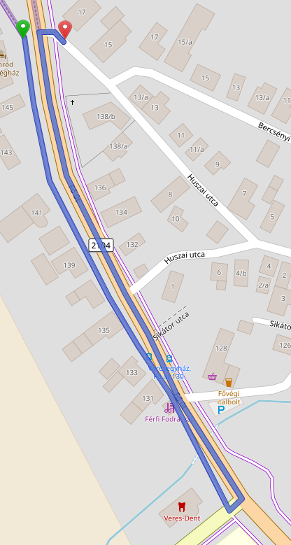
Összekötve jobb a helyzet:
Posted by kempelen on 14 April 2022 in Hungarian (Magyar).
Több mint 500 válasz érkezett a Wheelmap.org által kiírt közvélemény kutatásra, mely szerint: mi fontos a válaszadóknak.
A résztvevők 23%-a szeretne több információt az orvosi rendelők hozzáférhetőségéről. 14% mondta, hogy különösen a tömegközlekedéssel kapcsolatos hozzáférhetőségi információkat szeretne, és 13%-nak a nyilvános WC-k hozzáférhetősége a legfontosabb.
Arra, hogy egy-egy helyen mi a legfontosabb, a válaszadók 77%-a a kerekesszékkel való megközelíthetőséget jelölte meg. 25%-nak az, hogy a helyszínen elérhető-e segítség. 23% az emeletekre vonatkozó útmutatási rendszert emelte ki (ha jól értelmezem a fordítást!). A résztvevők nagy többsége egynél több funkciót említett a hozzáférhetőséggel kapcsolatban.
- Kerekesszékes elérhetőség
- Helyi segítség
- Emelet információs rendszer
- Írásban és hangban elérhető információk
- Információk könnyen érthető nyelvezetben
- Információk Braille írásban
- Jelnyelvet megértő segítség
- Csendes, nyugodt szoba (low-stimulus)
- Indukciós hurok hallgató rendszer - (nem tudom mi az)
Forrás: https://sozialhelden.de/blog/ergebnisse-wheelmap-umfrage/
(Már csak azt nem tudom, hogy mi lehet az oka, hogy a 10 hónappal ezelőtti OSM szerkesztéseimet sem tükrözi a wheelmap.org.)

As a corps member, I represented the mind the gap CDS group of the Ife central to address other fellow corps members on the relevance of maintaining digital well-being, and I emphasized how they can be digital citizens, by using their digital assets/products responsibly and effectively. I also addressed the digital product being either an asset or a liability, it either adds value to you or devalues you depending on how you use it.
Posted by AngocA on 13 April 2022 in Spanish (Español).
Last updated on 16 April 2022.

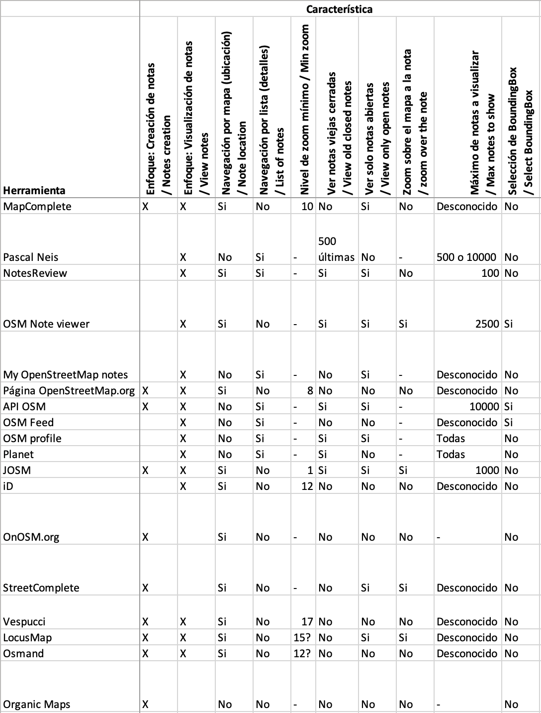
Esta es una comparación de características que ofrecen varios servicios / aplicaciones / páginas web que usan notas:
%20by%20Vince%20Emond.jpg)
Tldr;
-
We finally got some real life in-person meets!
-
Welcome to Emilio. Our new Sr Engineer!
-
We are hiring! We are on the hunt for a new Senior front-end designer/developer.
-
New TM deployment false start. New deployment Wed 12th April
-
Mobile mapping ‘ease of use’ experiments are underway.
Happy days, all!
Back for yet another month and wow did that month fly by! Literally, I boarded a plane for work purposes for the first time in 2 years!
First stop, Dakar, Senegal, where a few of the tech team members supported the launch of the new West and Northern Africa Open Mapping Hub. It was super exciting to see the way the hub will be leading with OSM community needs and how our tech can support. …
Read more here »

Looks like my diary here is going to turn into a development blog for my note viewer, which I’m going to call note-viewer in this post. I haven’t came up with a fancier name because I wasn’t sure what this thing was supposed to do other than being an alternative to user’s notes pages. Now I’m adding features that are not strictly for viewing notes. After all, you don’t want to just view notes, you want to do something about them.
Editing the notes along with the data
One of the things that you can’t currently do from my note viewer is to manipulate notes, that is you can’t comment or close them. You have to do those things either on osm note pages or in editors. What you can do is to go to a note page by clicking its id in the table, then you can do anything with the note that the osm website permits. It may not be very convenient though because you have to work with that note in isolation, without seeing related notes and other osm data. This lack of note editing functionality is there because I wanted first to implement a replacement for user’s notes pages. You can’t edit notes from those pages either.
But of course you want to edit the notes, usually along with related data. A note may tell about an error in the data, you edit the data, then you close the note. After that you move to another related note. Related notes are the ones you selected with note-viewer based on some criteria. That could be your own notes for some period of time made about some kind of objects. An example of such kind of use is described in my earlier diary entry. Another kind of note manipulation would be mass commenting/closing/reopening of selected notes, but the tool is not yet ready for that and we won’t look at this usage here.
Localização atual e precisa
تولید کننده قطعات استراتژیک صنعتی
Map

Its been crazy trying to edge match to natural water features, adjacent DNR and USFS properties, so I appreciate any help with the alignment problems after public land boundaries have been imported.
I started on the Cadillac FMU of the Pere Marquette- osm.org/relation/14031776
The Cadillac unit involved lots more crazy edge matching with the Gladwin Unit and Manistee NF units. I also started on the Kirtland’s Warbler Management Area (US Fish & Wildlife Service ownership), osm.org/relation/14032242, mostly nested within the Gladwin Unit and others. The Seney also has been mangled as I worked to resolve countless shared nodes with a road, so it will need a fresh import from the USFWS open data portal (https://gis-fws.opendata.arcgis.com/) and a relation created as well for the whitefish point area included in the national wildlife refuge.
Interesting to see someone put in Commercial Forest lands, MDNR property tax program enrollment that enables access for hunting and fishing. I am included to do a mass tagging of those already imported with an owner=private, access=permissive, hunting=yes tags. General access is not allowed, only hunting/fishing/trapping access.
As always, I am documenting status at: osm.wiki/Michigan/Parks
Posted by umbraosmbr on 12 April 2022 in Brazilian Portuguese (Português do Brasil).

Mapatona na Cidade de Boa Viagem(CE) Brasil.
Data: 07 de Maio da 2022.
Mapathon in the City of Boa Viagem(CE) Brazil.

Mapatona de Edifícios, Área Verde e Ponto de Interesse em Boa Viagem - CE - Brasil.
https://docs.google.com/forms/d/e/1FAIpQLSeiJNulOSqVGr30TNnB0VSmbKY0DuFS_aAMhMj1R7NO4VtkxA/viewform
Como MAPEAR:
Instruções para o Mapeamento na Cidade de Nanuque/MG. Edificios: Muitos edifícios são muito próximos mas na verdade não se tocam. Tente mapeá-los o mais próximo possível, sem permitir que eles se conectem entre si ou com as ruas.
Caminho para pedestre: Selecione a tag “footway” - caminhos acessíveis apenas a pé.
Área Verde “Mata Nativa ou Relfa”: Selecione a tag “natural=wood” - Para Mata Nativa ou natural=wood para Relfa.
Ponto de Interesse:
Posted by b-unicycling on 11 April 2022 in English.
Last updated on 17 April 2022.
To help me procrastinate from mapping the buildings in Co. Tipperary and because I came across one of them recently, I’ve decided to go on my own pursuit of Diarmuid agus Gráinne on OpenStreetMap. There are a couple of instances on the British War Office map all over the country that are marked as “Dermot & Grania’s Bed”. According to Irish mythology (to cut a very long story short), Grainne made Diarmuid flee with her from her engagement party, and they fled across the whole country, sleeping out in the open (first separate, later not so much).
Throughout history, secretive or mysterious places like caves, dolmens etc have been given that name. The legend is mentioned a couple of times in the Schools Collection on duchas.ie, so that is what I’m using now to track them down, because I cannot search the British War Office map. Unfortunately, I can only read the English texts… But their journey will be trackable, once I am done.
Maybe I’ll get to see one of them at some point.
I’m using the hashtag #Diarmuid&Grainne for my changesets, if anyone wants to check it out. Check for yourself on overpass-turbo. (Thanks, Daniel!)

The state of Texas is locally governed by Counties and not Parishes as in some countries. In Texas, if you see a road designated on the map as Pr 1111, that means Private Road, not Parish road.
The equivalent of a Parish Rd (a road maintained by a local government entity) would be CR 1111 which stands for County Road.
CR roads are often gravel or similar surfaces, especially in rural areas which are not near a major metropolitan area.
I recently published a blog article which serves as a “mega-tutorial” for getting starting an analysis project with OSM data using PostgreSQL and Python.
Check out the full article here: https://travishathaway.com/posts/2022-04-02-processing-osm-data-with-postgresql-and-python/
Cuando hablamos de datos libres y OSM, implícitamente suponemos que cualquier dato que encontremos en Internet lo podemos subir a nuestro mapa. Sin embargo, no es así. Es más, debemos tener varios elementos en cuenta antes de pensar en cargarlos a OpenStreetMap.
Lo primero que debemos entender es que un dato disponible en Internet no necesariamente es libre/abierto. Algunos datos son de dominio público, otros libres y otros son propietarios. Estos últimos son los datos que algunas organizaciones ponen a disponibilidad para solo sus usuarios; no para reutilizarse o hacer obras derivadas.
Con respecto a lo anterior, el concepto de “obra derivada” puede considerarse el hecho de imprimir una parte de un mapa. Esto quiere decir que el mapa ya no solo está disponible en Internet por medio de un visor web, sino que también está impreso en una hoja. Este es el caso de Google, que anteriormente prohibía imprimir parte de sus mapas (aunque ya levantó dicha restricción.) En términos generales, estas son las condiciones de uso que ponen los dueños de los datos, y que son muy restrictivas cuando son datos propietarios. Hay muchos otros ejemplos de obras derivadas, y consisten en basarse en algo existente para hacer algo nuevo (canciones en películas, nuevas canciones con estribillos, etc.)
Entonces, siempre tenemos que revisar la licencia de los datos que vamos a utilizar para mapear en OSM. Si no tiene una licencia explícita, no se deben usar en OSM. Si tiene una licencia, primero hay que ver si es compatible con la licencia de OpenStreetMap, la cual es Open Database License – OdbL 1.0.

It was quite exciting to meet virtually with the new team lead of OyoMappersTeam ,one of the founding team of Unique Mappers OSM Community Nigeria , The team was co-doundaed by Mrs Mary Marcellineus and Victor N.Sunday in 2017. The Team Coordinator, Mrs Mary was also excited to have us discuss ways of breaking barriers to community engagement at Oyo. One of the constraints she is battling is the access to internet connectivity for mapping which is very costly for members to afford . Most often she had to use part of her meager salary ,to ensure, a mapping event or training is hosted . In response, the team was given hope ,that ,such barriers is bound to be overcome as we all work together as a local community NGO for Nigeria -The Unique Mappers ,so we can seek for funding for humanitarian response mapping in Nigeria. If members were up and doing with annual dues/reg ,that would serve effectively to provide internet subscription support for the team but now we can only rely on possible micro grant and donations ,to help us provide sustaining fee internet subscription for mapathon. The team was advised at the moment to get Mi-fire for monthly subscription to hotspot for 32/64 participants or make use of their smartphones. While,Unique Mappers would always be there for the team to provide necessary support. The meeting was as an exciting way to wrap up the day’s activities for OSM volunteering
An appeal to the OSM community and its members!
Russia treacherously attacked Ukraine on 24 February 2022, striking with missiles and bombs at airports, military bases and civilian infrastructure. This was another escalation of hostilities that began in 2014 with the annexation of Crimea and the partial occupation of Donetsk and Luhansk Regions.
On behalf of the OSM Ukraine in connection with Russia’s ongoing military invasion of Ukraine we are turning to people who are contributing to the development and improvement of the OSM data.
We urge everyone to refrain from any mapping of the territory of Ukraine at the moment!
The Russo-Ukrainian War is unfolding on many fronts including the information one. The possible use of open data by Russian invaders to plan attacks on military and civilian objects is one of the most important reasons why we ask you not to perform any mapping of objects in Ukraine.
We shall take action to amend (delete, modify, revert to the previous state etc.) any found cases of mapping related to military or critical social infrastructure facilities as well as contact the DWG and other OSMF working groups to ban the users who systematically make similar changes (more than one).
Such a request (demand) echoes the provisions of the Article 114-2 of the Criminal Code of Ukraine according to which “Dissemination of information on redeployment, movement or location of the Armed Forces of Ukraine or other military formations established in accordance with the laws of Ukraine, if it is possible to identify them on the ground, if such information is not published by the General Staff of the Armed Forces of Ukraine, committed under martial law or state of emergency, shall be punishable by imprisonment for a term of five to eight years” (https://zakon.rada.gov.ua/laws/show/2160-20#n10).
Oyomappersteam executives had an interaction with Uniquemappers team executives on the training they had with Mercy, the Regional Ambassador.
In March 2022, On the International Women’s Day, I presented a talk “Open Mapping Tech for women in Climate Crisis” which gave an insight into what it takes for wonen to participate in mapping by leveraging on some of these applications so that their voices can be heard by the larger society/world. I was able to interact with some women from other countries. The program was anchor by Uniquemappers network Nigeria.