Users' Diaries

Recent diary entries

Welcome to my fifth OpenStreetMap NextGen development diary.
This week has been mostly focused on GPS Traces 🛰.

🔖 You can read my other development diaries here:
osm.org/user/NorthCrab/diary/

🐙 This project is open-source and publicly available:
https://github.com/Zaczero/openstreetmap-ng

GPS Traces Demo

It’s best to experience the refreshed traces in a video form, so I prepared a short demo (no audio):
⏯️ https://files.monicz.dev/osm/traces-demo.mp4

For comparison, here’s how the same trace looks on the current website:
osm.org/user/bielebog/traces/11326871

You will quickly notice the super-fast upload speed and the new trace animations. If there’s something wrong with the file you attached, you will receive instant feedback on the upload page. One new feature is possibility to edit trace name. Previously, this feature has been hidden behind API 0.6.

One more planned feature is rendering the map behind the trace animation. Now that the system works on individual coordinates, it will be fairly easy to implement. Traces without a human-understandable point of reference are not as useful as they could be.

Unified Traces URLs

Let’s start with discussing the current URL routes.

  • If you want to access a way, you visit /way/<ID>
  • If you want to access a note, you visit /note/<ID>
  • If you want to access a trace, you visit /user/<USER>/traces/<ID>

Which is not consistent. OpenStreetMap-NG unifies this experience by introducing a new URL route: /trace/<ID>. All existing URLs remain backwards compatible and are automatically redirected.

Short-Term Development Plan

There’s just a few things left before reaching the core feature parity with the existing website. Those are the things I want to finish before inviting new contributors ツ.

  • Elements sidebar (50% work in progress)
  • User Diaries
  • User Profiles
  • Applications (OAuth) settings

Contributor Benefits

See full entry

../

Posted by Raquel Dezidério Souto on 15 April 2024 in Portuguese (Português).

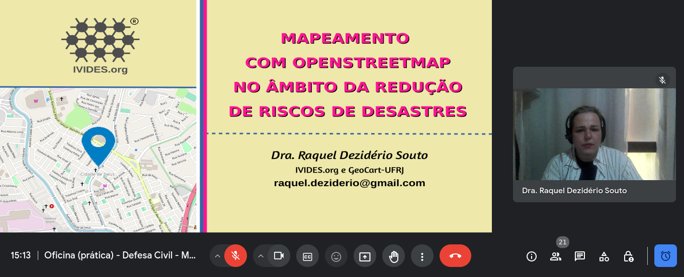
IVIDES.org® realizou mini curso sobre mapeamento com OpenStreetMap voltado à redução de riscos de desastres


No dia 11 de abril de 2024, o Instituto Virtual para o Desenvolvimento Sustentável - IVIDES.org, na pessoa de sua presidenta, Dra. Raquel Dezidério Souto, promoveu um mini curso sobre mapeamento colaborativo com OpenStreetMap e voltado à redução de riscos de desastres (RRD). O treinamento foi oferecido aos(às) servidores(as) de defesas civis de diversos estados do Brasil, como parte de um curso sobre logística para desastres.

Como parte dos documentos, foi incluída uma lista preliminar de feições relacionadas à RRD e as etiquetas correspondentes. Todos os arquivos da apresentação podem ser encontrados neste LINK.

https://ivides.org/wp-content/uploads/2024/04/foto1_vf2.png

See full entry

Posted by richlv on 13 April 2024 in English.

Having both GoPro Hero11 and Max360, I was curious whether there would be any use from running both cameras at the same time. While Max 360 captures all around, would Hero 11 possibly have better resolution, which could be useful for streetview platforms like Mapillary and Panoramax, thus also providing additional detail for OSM mapping?

Here’s the same object - a surveillance camera - from both action cameras. Hero11 is even a little bit further away.

Max360: Max360

See full entry

Posted by tbibby on 13 April 2024 in English.

My first diary entry in thirteen years, and so much has changed on OSM. The editing tools have come on so much, and there is now an incredible level of detail, even in the rural town I’m living in now. I think I need to go back to the documentation to refresh my memory and look at adding all the things missing in my neighbourhood.

Location: Nenagh North, Nenagh West Urban, The Municipal District of Nenagh, County Tipperary, Munster, Ireland

2024年4月3號花蓮外海發生規範 7.2 強烈地動,造成嚴重 ê 道路中斷 kah 人命傷亡。OpenStreetMap Taiwan 社群開設下跤三个專案,向望各界鍵盤圖客支援繪製花蓮 ê 建築、土地利用 kah 落勾 ê 道路 kah 溪流:

這馬佇咧參詳地動了後 ê 衛星影像捐贈 ē-tàng iōng tī 繪製新 ê 地貌,並且 tī 主要災後復原了後,期待直接 tī 在庄 ê 實體活動,幫助在庄 ê 人。

Location: 民有, 崇德村, 秀林鄉, 花蓮縣, 972, 臺灣

On April 3, 2024, an earthquake happened outside the coast of Hualien, which caused serious roadblocks and human casualties. OpenStreetMap Taiwan has opened 3 projects for mapping affected areas, requesting worldwide mappers to map buildings, landuses, missing roads or waterways in Hualien.

We are talking if there is a possibility to donate the newest satellite image after the earthquake to map the after-earthquake situations. And the possibility of hosting mapping events on-site after the affected area returns to normal, helping locals by mapping the newest map data.

Location: Minyou, Chongde Village, Xiulin, Hualien County, 972, Taiwan

2024年4月3日花蓮外海發生規範7.2強烈地震,造成嚴重的道路中斷與人命傷亡。OpenStreetMap Taiwan 社群開設以下三個專案,企盼各地鍵盤圖客支援繪製花蓮的建築、土地利用與遺漏的道路與溪流:

目前在洽談震災後的衛星影像捐贈用來繪製新的地貌,並且在主要災後之後,期待直接在當地的實體活動,幫助在地民眾。

Location: 民有, 崇德村, 秀林鄉, 花蓮縣, 972, 臺灣
Posted by GOwin on 11 April 2024 in English. Last updated on 22 April 2024.

That’s the name of the workshops I facilitated last week, with the goal of introducing/promoting OpenStreetMap, along with introducing tools like FieldPaper, OpenAerialMap, Sketch-Map Tool and Umap, to meet the objectives of local DRR practitioners’ upcoming mapping initiative.

image

Last Friday I had conducted two workshop in Iloilo, one (unplanned) for Iloilo’s Provincial DRRMO (disaster agency), and another for Iloilo City own DRRMO. In the Philippines, city charters may provide them autonomy from the geographic province they’re part of. These Disaster Risk Reduction Management Offices (a tongue-full, I know) are the government agencies responsible for mitigating localized disaster risks, and planning for disaster prevention for their respective territories.

See full entry

Location: Progreso-Lapuz, Lapuz, Iloilo City, Western Visayas, 5000, Philippines

While commercial map providers like Google, provide map data in local Indian languages, the local language labels are usually transliterated from English, resulting in errors. OSM, Wikidata and Wikipedia platforms provide a way to improve the local language maps leveraging multilingual labels through Wikidata identifiers on OSM, through semi automated updates. For good quality maps on Wikipedia and OSM, the Wikidata location needs to be accurate and Wikidata identifier should be uniquely mapped to the actual OSM geometry. I worked on removing the mismatches for villages of a district in Andhra Pradesh. I have documented my experience as clearly as possible, so that even users with less programming and tools skills can contribute to the work. As an example, identifying and fixing errors in Wikidata location is given below.

Identifying and fixing error in locations on Wikidata pages

See full entry

Location: Byrasandra, Bengaluru South City Corporation, Bengaluru, Bangalore South, Bengaluru Urban, Karnataka, India
Posted by Cyberjuan on 9 April 2024 in English. Last updated on 10 April 2024.

 As we announced in a previous post, we continue to inform the OpenStreetMap LATAM community about the SOTM LATAM 2024 committees, and now we present the Programming Committee.

The main functions of this committee are:

  • Propose the activity program during the days of the SOTM
  • Design protocol activities
  • Design the event Tracks
  • Design parallel activities
  • Design recreation activities
  • Coordinate with the speakers what is necessary for their participations
  • Evaluate the carrying out of recognition of mappers in the region

The committee members are:

See full entry

Location: El Porvenir, La Oroya, Province of Yauli, Junín, Peru
Posted by Cyberjuan on 9 April 2024 in Spanish (Español). Last updated on 10 April 2024.

 Tal como anunciamos en anterior post, seguimos informando a la comunidad OpenStreetMap LATAM sobre los comités del SOTM LATAM 2024, ahora les presentamos al Comité de Programación.

Este comité tiene como principales funciones:

  • Proponer la programación de actividades durante los días del SOTM
  • Diseñar las Actividades protocolares
  • Diseñar los Tracks del evento
  • Diseñar las Actividades paralelas
  • Diseñar las Actividades de recreación
  • Coordinar con los ponentes lo necesario para sus participaciones
  • Evaluar la realización de reconocimientos a los mapeadores de la región

Los miembros del comité son:

See full entry

Location: El Porvenir, La Oroya, Yauli, Junín, Perú
Posted by Cyberjuan on 9 April 2024 in English. Last updated on 10 April 2024.

 As we announced in the previous post, we continue to inform the OpenStreetMap LATAM community about the SOTM LATAM 2024 committees, and now we present the Academic Program Committee.

The main functions of this committee are:

  • Evaluate the presentation proposals received
  • Evaluate scholarship applications received
  • Management of travel and accommodation scholarships

As additional information for those interested in presenting a talk or presentation, the topics may be (but are not limited to):

See full entry

Location: Villa del Mar, Huanchaco, Province of Trujillo, La Libertad, 13013, Peru
Posted by Cyberjuan on 9 April 2024 in Spanish (Español). Last updated on 10 April 2024.

 Tal como anunciamos en el anterior post, seguimos informando a la comunidad OpenStreetMap LATAM sobre los comités del SOTM LATAM 2024, ahora les presentamos al Comité de Programa Académico.

Este comité tiene como principales funciones:

  • Evaluar las propuestas de ponencias recibidas
  • Evaluar las solicitudes de becas recibidas
  • Gestión de becas de viajes y alojamiento.

Como información adicional para quienes estén interesados en presentar una charla o ponencia, los temas de estas pueden ser (pero no están limitadas a):

See full entry

Location: -8.098, -79.075