Users' Diaries

Recent diary entries

Posted by Barro on 12 June 2023 in Finnish (Suomi). Last updated on 25 June 2023.

Loin joskus yli 10 vuotta sitten OpenStreetMap-tunnuksen ja tein silloin yhden päivityksen. Silloin ei oma halvalla hankittu ainoa älypuhelimeni oikein soveltunut käytettävyytensä puolesta OpenStreetMapin datan keräämiseen ja muutenkin työkalut tällöin oli käytettävyysmielessä vähän mitä sattuu.

Sitten pari vuotta sitten tuli vastaan tilanne, jossa yritin keksiä, että mihin pysäköidä pyörä Helsingin keskusta-alueella lähelle määränpäätä siten, että sen saisi järkevästi rungosta lukittua. Kun tajusin, että tämän datan voisi olla hyvä löytyä OpenStreetMapista, niin aloitin sitten oman projektin pyöräparkkien kartoittamiseksi alueilta, joilla liikun.

Valitaan mitä kartoitetaan

OpenStreetMap on loputon suo sen suhteen, että mitä kaikkea siinä voi kartoittaa. Päätin itse rajata oman panokseni koskemaan noin suunnilleen seuraavia tilanteita:

  • Lisätään kartalle pääasiassa runkolukittavia pyörätelineitä. Perinteiset kiekonväännintyyppiset helposti siirrettävät telineet, joita löytyy ripoteltuna sieltä täältä saa jäädä lisäämättä.
  • Poikkeuksena tilanteet, jossa kyseinen teline on jo kartalla ja se tarvitsee tietojen päivitystä. Tai jos näitä kiekonväännintyyppisiä telineitä on paljon yhdessä paikkaa.

Nämä rajaukset siksi, että se vähentää työmäärääni ja ylläpitää paremmin mielenkiintoa OpenStreetMapin päivittämiseen. Osaksi tämä on myös arvovalintakysymys, sillä jos siinä on edes teoreettinen mahdollisuus, että tuomalla OpenStreetMapiin esiin hyviä ratkaisuja yli huonojen, joku voi hyödyntää tätä tietoa omassa päätöksenteossaan. Käytän myös itse aina välillä kartalle lisäämääni tietoa hyväkseni. Omassa käytössä luonnollisesti suosin sitä, etten joutuisi kärsimään huonolaatuisista ratkaisuista.

See full entry

Last week, the climate officer from my local county council reached out to me to see whether “we” (i.e. OSM) had locations for drinking_water:refill mapped. (She used to be the heritage officer, so she knows well what I do).

After some confusion about what she meant (I thought holy wells…), I found that there was one mapped as amenity=drinking_water, but without the drinking_water:refill tag.

I presume the reason she is asking is that the council wants to install more, but doesn’t know where there are already some.

Some more research revealed that there are at least two providers in Ireland, both use GoogleMaps, one not very successfully: EcoFil. In agreement with the OpenStreetMap Ireland board, I sent emails to both companies to ask whether they could make their datasets open giving the county council analysis as one example for the usefulness of #OpenData in this case, pointing out that they could also benefit from a complete dataset.

(overpass-turbo for Republic of Ireland)

Refill Ireland sticker

See full entry

Posted by krschap on 8 June 2023 in English. Last updated on 15 June 2023.

Introduction

The purpose of this document is to explore the possibilities of the Segment Anything Model (SAM) Segment Anything developed by Meta in OpenStreetMap mapping. SAM is a promising model in the field of image segmentation, and its potential application to fAIr could enable the tracing of various features on maps. This document provides an overview of SAM’s working mechanism, test cases conducted with SAM, and two potential integration ideas for utilizing SAM

SAM Working Mechanism

SAM operates directly on images and generates individual masks based on the training datasets used during model training. Unlike object detection models, SAM focuses on segmenting all elements present in an image, regardless of their nature, based on texture, color, and points of difference from the background and several others can be found on their research doc SAM Working Mechanism

Advantages of SAM for fAIr and OSM Mapping

See full entry

Thanks to planetiler, it is possible to run your own OpenMapTiles vector tile server on Amazon Web Services (AWS) for less than $20 per month. This guide describes the process that I used to stand up tile.ourmap.us for the OSM Americana project, and it does require some knowledge of AWS. However, I taught myself how to use AWS, and I’ve tried to include enough details here to assist someone trying to stand up their own tileserver.

There are many different ways to do this, including different storage, hosting, and tileserver setups. This is just one option that worked for me for what I was trying to do.

The architecture

This setup in this guide assumes that infrequent planet updates is acceptable for your use case. So, we will spin up a powerful server to update the map only when needed, and use a low-powered server to run the HTTPS tile server on an ongoing basis. If you require more frequent map updates, this is probably not a good solution and you should consider dedicated hardware. The main advantage of AWS in this use case is the ability to rent a high-performance computer for a short period of time.

Additionally, this setup assumes that you already own a domain name that you can use to point to the tile server. If you don’t have one, you can purchase one on Google Domains for $12 per year.

In our setup, we will render a planet to a large file in .mbtiles format, and use tileserver-gl to serve that .mbtiles as an HTTPS server.

Another advantage of using AWS is that they host a locally-mirrored copy of the planet file. Therefore, it is posible to download the planet in a few minutes, which reduces the amount of time that we have to rent that high-powered server to render the planet.

When we say “render the planet,” it means the following operation:

See full entry

Posted by tregeagle on 7 June 2023 in English.

The startling regularity of these posts amazes even me. Today I went for a bit of a walk with my brother Joe’s dog, Pumpkin. It’s an embarrassing name. Joe and his kids seem to shorten it to Pumpki. My mouth and memory struggle with that so I have been trying Pumki, Pumpi and Punki. Pumpkin does not respond to anything I say so I have tended toward Dog or Hey You. I resorted to buying a packet of dog treats in a mildly successful effort to be noticed.

OSMAnd has been very handy as usual to find my way. I found a broken bit on the map and tried to fix it but I don’t really know what I’m doing. I did record my track, hopefully that’ll help someone.

Location: Wylam Wood, Wylam, Northumberland, North East, England, NE41 8HX, United Kingdom

For some months now, Champs-Libres has been working for the NMBS/SNCB, the national railway company of Belgium, for reusing OSM data of Belgian stations. The NMBS/SNCB has an interest in OSM data for improving some services to travelers regarding accessibility data, especially for bicycles. Have a look at the wiki page for more insights!

The first diary entry was about the basic data on the Belgian stations and platforms. In this second diary post, we’ll show how to map access to the railway platforms.

What is the access to a railway platform?

A traveler, with or without a bike, can walk to/leave a platform by several means of access. We’ll call these “access objects”, which can all be mapped in OSM. Here is how to map these access objects and how they are mapped in the Belgian train stations. We hereby focus on travelers walking through stations with their bikes.

Elevators

Elevators are represented in OSM with a single node (most of the time) and the tag highway=elevator. The following overpass query https://overpass-turbo.eu/s/1pm1 gives 90 elevators that are strictly to and from the platforms. They are mostly found in the larger train stations. However, we noticed that some elevators were not identified by this query because they were slightly outside of the platform area. This should be corrected in most cases.

See full entry

Location: 50.469, 4.862
Posted by Qwajo OSM on 6 June 2023 in English. Last updated on 20 June 2023.

As it stands, I believe the need to rekindle the interest in volunteerism among members of the open mapping community is a necessary evil. This belief results from personal experience as well as other colleagues’ experiences. I joined the open mapping community through Youthmappers in 2016 and have been actively involved since then. Mapping has been fun and competitive since I joined the community. Thus, at the local chapter level, national and international levels, I have enjoyed a series of mapathons that were fun and competitive. A major event I can recall is the Malaria mapping challenge, where mappers from the University of Cape Coast were rewarded with some GPS devices at the end of the challenge to boost their mapping activities. Memories from the challenge put smiles on my face to this day. I can recall that some members of UCC Youthmappers were happy to answer a midnight call, trade sleep, and map to contribute to the malaria challenge and help the chapter compete as well.

I take a closer look at some of the local chapters in my home country these days and that zeal and interest seems to be dying off. That is a worry that needs attention, especially from the Gurus in the community. We have to encourage old members to share the positive impacts and personal experiences they have had so far with members who are losing interest to revitalize their interests.

Also, competitions should be enrolled more often and at all levels to be sure no one is left out. Finally, all members contributing every bit of data should be given some recognition so everyone feels involved. Let us keep the community running and keep the volunteering spirit moving!

Location: Community 18, Sakumono, Tema West Municipal District, Greater Accra Region, Ghana
Posted by spughetti on 6 June 2023 in English. Last updated on 7 September 2023.

Introduction

About 2 weeks ago I found San Francisco’s open data website, on it was this dataset containing 70 murals along with information about their artist and Cultural District. I used SF Mural Arts as a source for the names of some of the murals.

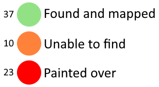
I’ve uploaded all the files I used for this project here. I used a spreadsheet to track my progress, the file is called “StreetSmArts_Murals_progress.ods”. You can find way IDs in column Q and notes in column S. This legend explains what each colour used in the spreadsheet means and how many murals belong in each category. Legend to explain each of the colours used in the spreadsheet along with how many murals belong to each category. Green (37 murals) means found and mapped, orange (10 murals) means unable to find and red (23 murals) means the mural was painted over. If you are unable to see this legend you may be looking at an archive of this diary entry, please go to https://ia902608.us.archive.org/24/items/Importing-StreetSmArts-Murals-in-San-Francisco/legend.png to find the image.

Tagging Schemes

There weren’t any tags for some of the information in this dataset so I came up with some new tags in the process.

Cultural Districts

Some of these murals are within certain Cultural Districts, which from what I’ve read on their websites are basically just a fancier version of neighborhoods that organize events to celebrate the culture of those within the district.

See full entry

Location: Civic Center, Tenderloin, Mission, San Francisco, California, 94102, United States
Posted by Z_Empty on 6 June 2023 in Chinese (China) (‪中文(中国大陆)‬). Last updated on 11 June 2023.

绘制城市建筑物的过程中,建筑物的名称成了一个问题。比如,假如绘图者正在绘制上海浦东新区陆家嘴,当ta绘制到上海市浦东新区银城中路501号时,可以很快打上“上海中心大厦”的名字。但是并不是所有的建筑物都这么知名,往往最多只能查到一座建筑物的门牌号,而无法查到这座建筑物的名字。
当然实际上这不是什么大问题,不过是缺乏建筑物的名字而已。但是还是希望能有个渠道查找到这些信息,毕竟这是城市信息和城市记忆的组成部分。

Location: 桔子洲街道, 岳麓区, 湘江新区, 岳麓区, 长沙市, 湖南省, 中国

Hello!

I’ll be working on developing Python bindings for the OSRM project for GSoC this year.

I’m pretty excited to say the least, as mapping/navigational data is something that I find genuinely fascinating and important, but also because I’ll be able to learn about working on a project via hands-on experience - with guidance from some really nice mentors.

A little bit about me - I’m most comfortable writing C++ code, as it’s the language I have used the most by far. That said, I’m also interested in all things development related, so it’ll be a good opportunity for me to learn more about bindings and the Python side of things.

Posted by JM-Lemmi on 5 June 2023 in English.

Mapping the Weinsberger Berge

Inspired by Tom7 to go outside more, I set myself the goal of biking every Forestpath between Weinsberg and Heilbronn, before I will be moving avay in the Summer.

In the process I stumbled across many Tracks that need updating. Many have overgrown to the point of unusability, others are not mapped yet. One of the biggest challenges for the Forest in my opinion is deciding which Harvester Tracks should be mapped and which not. On a normal Field you wouldnt map every Tracktor Track, but in the Forest these Paths sometimes turn into paths used by the public. They are pretty volatile though. In the tree felling season they look like high traffic Tracks, very compacted, traversible by normal Trucks. But they are also not maintained, so quick to overgrow and turn very muddy to barely passable with a bike after a few days of rain.

This weekend I was able to complete the 4th of my areas and I wanted to take stock. I have driven every Path between Donnbronner Landstraße, Heilbronn and L1111. This includes the Schweinsberg, the vineyards, Köpfertal and Büchelberg. I also drove every path in Weinsberger Tal and the Waldheide between Donnbronner Landstraße, A81 and the Verwaltungsgrenze Weinsberg in the South.

See full entry

Location: Kernstadt, Heilbronn, Baden-Württemberg, Germany
Posted by Jan Olieslagers on 3 June 2023 in English.

Contrary to common practice, I hold (after much deliberation and consideration) that the best way to map runways is to make them an area.

One reason is that everybody and their dog, including our very own dearest wiki, defines a runway as being an area, with various elaboration. Example from our own wiki: [quote]A runway is a defined rectangular area on a land aerodrome (aeroway=aerodrome) prepared for the landing and take-off of aeroplanes. [/quote].

The eternal counter-argument is the parallelism to ways, railways, waterways and perhaps more; but I hold this argument to be non-valid. Unlike all the other categories, runways can NOT be joined to create routes. An aviator’s route planning mentions aerodromes and optionally other waypoints, navaids, visual reference points, but never runways. So that there is really no point in defining a runway as a way, or any other linear element.

I therefore strongly oppose both the mapping of runways as linear elements, and the additional use of area:runway or any such. The latter are totally redundant, and thus a waste of valuable resouces, storage capacity in the first place.

I am not the only mapper with this opinion, even less am I the first; many French ultralight terrains and their runways (“Base ULM”) have been mapped this way, and never been questioned. I find them perfectly satisfactory, too. For just one example among many, see [url] osm.org/way/587820283 [/url]

What is Hasiru Aqua & what do they do?

Hasiru Aqua, a leading agritech startup, is transforming the aquaculture landscape by providing vital support to farmers in Karnataka, India. Their efforts in increasing fish yields have significantly boosted farmers’ incomes and improved the overall socio-economic well-being of farming communities. Additionally, by incorporating fish into local diets, Hasiru Aqua is enhancing the health outcomes of individuals.

Hasiru Aqua 1

Why does Hasiru Aqua require mapping?

See full entry