Diary Entries in English

Recent diary entries

Posted by seism on 23 December 2018 in English.

Strewn around the village of Ringgenberg, the Ringgenberg-Goldswil Planet Walk (or “Planetenweg Brienzersee”, as it was originally titled by habi 3 years ago) is a not very prominent, but enjoyable local attraction.

There are about 20 such planet walks in Switzerland. My children just had the topic of space exploration at school, so they were very motivated to go from stop to stop, looking at the scale models of the planets and reading the information boards. And I realised that only the first three of the planets were to be found in OSM.

This is my first time editing OSM with this user account (I seem to have lost access to older ones), and on top of that I was using Vespucci as an editor for the first time. But the process was pretty intuitive, and I managed to link my new nodes to extend the existing Relation, as well as make some changes to the underlying data.

The question of who maintains this walk is a bit open. Only the English Wikipedia entry for the village currently mentions the walk, and online I could only find basic references to it from the local (archived) and national tourist boards. The only other source of information, besides mentions from local tour guides, is the Swiss Astronomical Society. If anyone finds more literature, I would be keen to know when this was built, and how it is maintained.

I’ve only gotten as far as Saturn today, which leaves 4 points, including Pluto, out there to discover and map. Maybe tomorrow.. And if you have comments on my Changesets or any other ideas for how to contribute to OSM in the region, please let me know!

In the meantime ..

Merry Christmas !

osm.org/changeset/65718390 osm.org/changeset/65718443 osm.org/changeset/65718564 osm.org/changeset/65718644 osm.org/changeset/65718683 osm.org/changeset/65719021

Location: Spycherli, Ringgenberg (BE), Interlaken-Oberhasli administrative district, Oberland administrative region, Bern, 3852, Switzerland

I just learned about cesium.com/ion. It is a website that allows one to create ‘Assets,’ or sets of 3d-tiles, and host them for a cesiumjs.org instance such as webglearth.com ( 3d Leaflet ) . One can choose to upload (3d aerial photogrammetry)[https://cesium.com/docs/tutorials/uploading/] that gets carved into vector 3d tiles that are hosted as an Asset through Cesium. Each tile is one WebGL draw call.

Somebody might want to grow these 3d-tiles from the ground up artificially if he can’t fly from the skies. An Asset producer may regularly update from OSM in order to parse the tags for elevation, vegetation, buildings, etc in order to grow the tiles based on tags.

Some fun with Assets: let’s say you had 3 ‘visibility layers’ to choose from, those being buildings, vegetation, and terrain. To maximize efficiency, you should host X Assets if you have Y visibility options: X := Σ for n=1..Y, Y choose n. Basically, one Asset for every possible selection.

Location: Ventura County, California, United States
Posted by ika-chan! on 21 December 2018 in English.

I wished that setting up a standalone OpenStreetMap server, with the likes of Rails, Mapnik and Nominatim all in one computer, was as easy as setting up MediaWiki. I think that the ease of setting up MediaWiki is why MediaWiki-based wikis are so popular.

If setting up a standalone OpenStreetMap server was as easy as setting up MediaWiki, many people would be mapping their own worlds on their own servers, saving OpenStreetMap the headache of dealing with fictional edits.

Long story short, I still wish to set up a standalone OpenStreetMap server for my NationStates nation under Ubuntu 18.04 LTS, but I think I will need help with the development of a simple method to set-up such a server — not only due to my poor health, but also to make things a lot easier for other fictional mappers that can’t fit their worlds into OpenGeoFiction.

I am sorry about the request for help with the server setup instructions, but my health matters more. At least I got my feelings about the complexity of setting up such a server out of the way before it overwhelms me.

Posted by kocio on 21 December 2018 in English.

Dear all,

Today, v4.18.0 of the OpenStreetMap Carto stylesheet (the default stylesheet on the OSM website) has been released. Once changes are deployed on the openstreetmap.org it will take couple of days before all tiles show the new rendering.

Changes include

  • Adding rendering for healthcare tag scheme
    • Changing hospital icon
    • Changing healthcare color to red
  • Changing natural=scrub color
  • Changing landuse=allotments color and pattern
  • Adding rendering for natural=cape
  • Rendering leisure=ice_rink
  • Adding rendering for man_made=crane
  • Adding icons for shop=fabric and shop=carpet
  • Updating icons for amenity=arts_centre, leisure=slipway, amenity=restaurant/amenity=food_court and man_made=storage_tank/man_made=silo
  • Using dedicated icon for artwork_type=bust
  • Rendering railway pattern on z12
  • Showing labels of big states (like Alaska)
  • Moving railway=tram_stop and station=subway later
  • Adding rendering for more private POIs
  • Removing smoothing in leisure=track and attraction=water_slide
  • Using subway bridge style for subway construction bridges
  • Rendering wind turbines names and other tweaks
  • Changing man_made gray and text color, making text-dy uniform
  • Small documentation and code fixes

Thanks to all the contributors for this release including tpetillon, a new contributor.

For a full list of commits, see https://github.com/gravitystorm/openstreetmap-carto/compare/v4.17.0…v4.18.0

As always, we welcome any bug reports at https://github.com/gravitystorm/openstreetmap-carto/issues

Posted by SimonPoole on 20 December 2018 in English.

Now that Vespucci 12 is already nearing release (if you are helping with the translations, please have a look at them asap, as they are the major hold up), it’s time to think of what is coming next.

Vespucci has supported unconnected mapping since day one (nearly a decade ago) and that has improved over the years with addition of support for reading and saving files in normal OSM and JOSM xml format (the JOSM format stores information on local changes).

In version 10.1, early this year, we added support for MBTiles files for local on device background imagery sources, supporting building an imagery source while you are online on your desktop and avoiding having to download to Vespucci imagery cache manually which tended to be rather tiresome.

But despite all of this, the main problem remained that you need to keep OSM data files on device reasonably small because the contents would be read in to memory and while such areas can be quite large on a modern phone, things tends do to get slow. And as we all know when you make a selection in advance, Murphy comes in to play and you are surely are going to miss exactly the area that you suddenly stumbled in to.

To get around all of that I’ve been investigating a compact, indexed in one way of the other, on device format for raw OSM data for quite a while, and now have a solution that works even better than what I originally envisioned.

See full entry

Posted by skunk on 20 December 2018 in English.
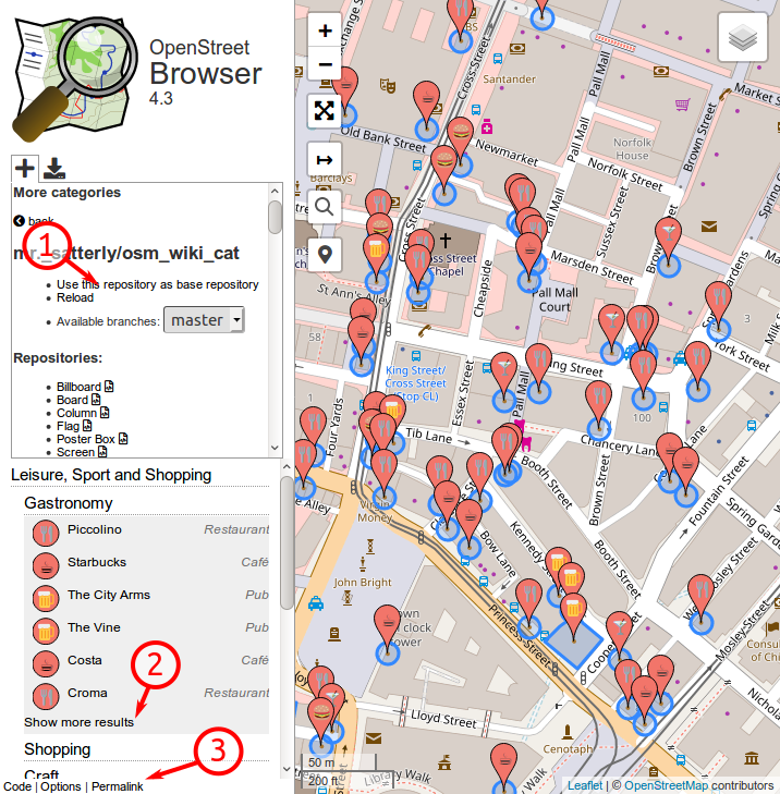
  1. Custom repo: It’s possible to create custom categories for some time now, now you can load an alternative repository as base categories. E.g.: The categories of user mr. satterly. In the repository selector, there’s a link “Use this repository as base repository”.
  2. Collapsed lists: The lists of map features (of a category) are now truncated, and there’s a link “Show more results” which will show you the rest.
  3. Permalink: As requested, there’s now a “Permalink” in the menu at the bottom.

New features of OpenStreetBrowser 4.3

Read more about OpenStreetBrowser on the blog.

Posted by wille on 20 December 2018 in English.

Hello! The year is at the end, but we are right in time to share some updates in OSMCha. We have some new features that will make us save time when reviewing changesets and prioritizes the users whose changesets need more attention.

Now we can maintain a list of users that we trust and another of users that we want to be watching and reviewing their changesets.

You can add and remove a user to your trusted users or watchlist from inside the user panel tab on the changeset page.

We have a new user menu that allows us to access and manage our account settings, the saved filters, the trusted users, and the watchlist.

See full entry

Posted by naveenpf on 20 December 2018 in English.

Mapping Efforts

Road improvement Coverage

As on today in Openstreetmap, 16 lakhs km of road length mapped out of 56 lakhs km of roads in India.In 2018, we crossed Japan and Canada in total kilometres of roads by country in Openstreetmap. Starting of the year OSM had 13.66 lakhs kms or road length in India. Roads are mapped manually at the rate of 2 lakhs kilometer per year. OSM India would take 20 years to completely map full road network in India (if it is done manually).

National Highway and State Highway Mapping

Every month egazette notifications are monitored by Openstreetmap community. For every new NH announced it will be mapped in OSM. We re-use national highway mapping in Wikipedia and Wikimedia maps are powered by OpenStreetMap. Community has started mapping of state highways in all states. One of main problem community is that lack of data. Out of 36 States/UT we have data only for 22 . For other states, state highway data is not even available in a list format. About 1.5 lakh people die on Indian roads every year. We need better road data to plan, monitor, and manage infrastructure more effectively. In India a death occurs every 3.5 minutes due to road accidents

Disaster Response Mapping

OSM community was part of disaster response mapping. Community worked with an organisation called Humanitarian OpenStreetMap Team (HOTOSM) to map disaster affected areas. Floods in Kerala, Cyclone Gaja in Tamil Nadu, Landslides in Coorg, Karnataka and flash floods in Nagaland, all were devastating. More than 3000 volunteers from across the world were part of 2018 India disaster response mapping. About 25,000 kms and 5,00,000 buildings were remotely mapped through disaster response mapping. Please try mapping here

Indic Language Maps status

See full entry

Location: Madathikara, Mukundapuram, Thrissur, Kerala, 680100, India

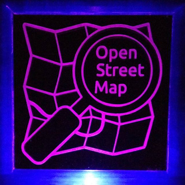
Laser-etched edge-lit sign

(or if image link doesn’t work - https://scruss.com/blog/2018/12/17/they-wont-miss-our-table-at-the-next-mappy-hour/)

How to make this: Edge Lit Acrylic Frame - 100 × 100 mm by scruss - Thingiverse

Logo derived from Monochrome sticker on OSM logos page. Would be happy to share if anyone wants it.

Location: Kennedy Park, Scarborough Southwest, Scarborough, Toronto, Golden Horseshoe, Ontario, Canada

The data volume for all of Turkmenistan is too large for Maperitive to handle, so I have contacted Igor Brejc, Maperitive’s creator, and he has produced, charging only his standard fee, a wall map-sized SVG image of Turkmenistan and its trunk, primary, secondary, and tertiary highways plus cities and towns. I am presently editing it with Inkscape to produce a wall map of Turkmenistan’s highways at the request of the American Embassy Ashgabat motor pool. First, a big thanks to Igor (https://scalablemaps.com/), and second, to the OSM community that has encouraged and tutored me along the way, as well as contributed a lot of data to the Turkmenistan map. This map, when ready, will be the most up-to-date wall map of Turkmenstan’s highway network.

I have also started work on a new wall map of Ashgabat, and so have updated the Maperitive mrules file for it, which you are welcome to peruse via the OSM wiki at osm.wiki/OSM_on_Paper/Printing_via_Maperitive,_Easy_Poster_Printer_and_Microsoft_ICE/Ashgabat_city_Maperitive_style_file It is not yet a finished product. I still want it to render the airport terminals as white, and my efforts so far in that regard have led to naught. They remain brown, like other buildings.

My best wishes for the holiday season to one and all!

Posted by mrchuks on 16 December 2018 in English.

Last Friday 14th, we organised a webinar with Mr Johanes Petro from Open Map Development, Tanzania. He introduced us to OpenMapKit (OMK) and OpenDataKit (ODK). It was very enlightening. I have installed the apps on my phone and look forward to sharing the knowledge with our students at the Unilag Mappers Team. ODK and OMK will become very useful tools in field surveys for their student projects and other activities.

Location: Akoka, Shomolu, Lagos State, 101233, Nigeria

I want to provide a bit of analysis here for this year’s OSMF board election results.

The election was ultimately uninteresting in terms of STV voting dynamics since the final results were the same as what they would have been based on first round results only. None the less i want to look at the second choices here.

In STV voters give a priority list of candidates. It essentially says: I want to vote for <position 1> on my list but in case that vote would be pointless for some reason i give my vote to <position 2> and so on. One of the most interesting thing to look at in the ballots is the second choices grouped by first choices. Below you have for example the 189 people who voted for Tobias on position 1 (27.7 percent) grouped by who they voted for at position 2. The most popular choices were Joost with 82 votes (43.3 percent) and Guillaume with 64 votes (33.8 percent). Same for the other candidates. Here are the numbers:

Tobias Knerr 27.7 (189)

  • Jo Walsh: 8.46 (16)
  • Geoffrey Kateregga: 5.29 (10)
  • Joost Schouppe: 43.3 (82)
  • Guillaume Rischard: 33.8 (64)
  • Miriam Gonzalez: 4.23 (8)
  • Nuno Caldeira: 2.11 (4)

Jo Walsh 5.44 (37)

  • Tobias Knerr: 13.5 (5)
  • Geoffrey Kateregga: 16.2 (6)
  • Joost Schouppe: 21.6 (8)
  • Guillaume Rischard: 13.5 (5)
  • Miriam Gonzalez: 32.4 (12)
  • Nuno Caldeira: 2.70 (1)

Geoffrey Kateregga 10.0 (68)

  • Tobias Knerr: 13.2 (9)
  • Jo Walsh: 0 (0)
  • Joost Schouppe: 25.0 (17)
  • Guillaume Rischard: 8.82 (6)
  • Miriam Gonzalez: 44.1 (30)
  • Nuno Caldeira: 4.41 (3)

Joost Schouppe 20.4 (139)

  • Tobias Knerr: 19.4 (27)
  • Jo Walsh: 4.31 (6)
  • Geoffrey Kateregga: 14.3 (20)
  • Guillaume Rischard: 17.2 (24)
  • Miriam Gonzalez: 39.5 (55)
  • Nuno Caldeira: 2.87 (4)

Guillaume Rischard 13.3 (91)

  • Tobias Knerr: 38.4 (35)
  • Jo Walsh: 5.49 (5)
  • Geoffrey Kateregga: 4.39 (4)
  • Joost Schouppe: 35.1 (32)
  • Miriam Gonzalez: 15.3 (14)
  • Nuno Caldeira: 0 (0)

Miriam Gonzalez 17.2 (117)

See full entry

Each and every year I’m impressed by the progress the OSM community has made. Supporting that community is at the core of the OpenStreetMap Foundation. This year the OSMF had its own progress as well, including within the board.

We kicked of the year with a generous donation from the Pineapple Fund which was worth over €200,000. What a wonderful surprise to start the year!

Less of a surprise was work this year to work on making sure OSM and the OSMF are in compliance with GDPR. One of the board’s roles is to approve policies and guidelines, we did quite a bit of that this year. Some updates were because of GDPR and others were policies that did not exist, but were needed.

A few policies were updated this year primarily due to the hard work of the Legal Working Group. The Trademark Policy was updated. Additionally due to GDPR the Privacy Policy and the Terms of Service were updated.

The Organized Editing Policy was developed by the Data Working Group and approved by the board this year to provide guidelines for organizations and groups editing together in a directed fashion.

Fee Waiver Program is not new, but had not as of yet been implemented. The Membership Working Group developed a process for those unable to technically pay and will be developing further process for those with financial hardship. The OSMF Board has already begun an approval process for those requesting a waiver who wish to claim financial hardship.

The OSMF moved in two different ways this year as well. There was a data center move I really appreciate all the hard work the Operations Working Group put into this move.

The year our official address moved as well. Certainly less dramatic than the server move, but important nonetheless. Thanks to Andy Robinson for all the years of hosting as the mail center for the OSMF.

Our new address if you ever need it is: OpenStreetMap Foundation St John’s Innovation Centre Cowley Road Cambridge CB4 0WS United Kingdom

See full entry

Location: Winlock, Lewis County, Washington, United States

As we approach the 2018 OSMF general assembly, I am extremely thankful for the support and endorsements that I have received from mappers.

Peter Barth, who is retiring from the board, has said some very nice things about me on the German Radio OSM podcast, chapter 32.

Christian Quest, cofounder and speaker of OpenStreetMap France, has endorsed me in a blog post:

The absence of conflict of interest and a good knowledge of the community in its diversity seem to me to be the main criteria.

Richard Fairhurst, former OSMF board member and father of the Potlatch editor and cycle.travel, has tweeted some of the nicest things about me:

I hope [Guillaume Rischard] is elected: smart, grounded, widely experienced and with a real sense of OSM’s potential, he’d be a great asset to the board and to the project in general.

I’m delighted to see the likes and retweets that this received from other mappers too.

You don’t expect candidates to endorse another, but that’s what Jo Walsh tweeted:

I’m impressed with the amount you’re doing for OSM behind the scenes and hope you get elected, as grassroots members would trust the Board more if you were on it.

Then there are all the wonderful private messages of support and encouragement. Thank all of you.

Thank you to all the OSMF members – the fact that we’re 1041 voters this year shows how many care about the OSMF. Thank you to my fellow candidates, for your time investment, for the positive campaign and for the spirit of comradeship I have felt with you.

510 people have already cast their ballot. If you haven’t yet, you have less than 24 hours to do so. The last election was decided on 19 votes, so your vote matters! Please vote, encourage OSMF members around you to vote. A high turnout will make the community stronger and the OSMF more resilient.

If you haven’t chosen for whom to vote yet, here are my answers to the official questions and manifesto.

See full entry

Location: Hollerich, Luxembourg, Canton Luxembourg, Luxembourg
Posted by combloop on 14 December 2018 in English. Last updated on 29 December 2018.

It’s been a short time of 16 days since I finished editing Hackensack, and I’ve already finished Leonia! Not quite as fast as I was hoping (Palisades Park took around half as many days), but still pretty good in my eyes.

I don’t know much about Leonia, but to me it seems like a less dense extension of Palisades Park. It still is pretty dense, but not quite as dense as Palisades Park which has around 4 times more people per square mile.

Next up is Maywood, which borders two places I’ve already mapped: Hackensack and Paramus. Maywood is pretty small and somewhat dense, and that’s what I like when mapping!

I’m almost at 700 edits, and I’m hoping to reach that milestone very soon while mapping Maywood.

I’m at 6 out of 70 places in Bergen County done, and it’s only been slightly less than 6 months. I’ve covered 11% of the county’s land area, which I’d say is pretty good!

Click below to see Leonia!

Location: Leonia, Bergen County, New Jersey, 07605, United States