Diary Entries in English

Recent diary entries

Posted by Polyglot on 1 December 2018 in English.

In October I went the Hack Weekend in Karlsruhe. It was great to meet with several of the developers of our beloved JOSM editor.

I was also able to demo the new features of PT_Assistant to people with a similar interest in the mapping of public transport.

I think the turn-by-turn based composing of itineraries is a big step forward. If the routing helper can find valid itineraries in other route relations, it will propose those as well. The user can then select 1,2,..,5. It is also possible to backtrack using 9, or to skip using 7.

Now I started working on validating the names, from and to tags in the route’s names. And proposing to add a route for the opposite direction of travel when converting to PT v2.

If no route_master exists yet, the plugin will propose to create one.

Location: Weststadt Mittlerer Teil, Weststadt, Karlsruhe, Baden-Württemberg, 76133, Germany
Posted by pnorman on 1 December 2018 in English.

There’s a healthy number of candidates for OSMF board this year, so I made a matrix of candidates and the questions they were asked, and thought it might be useful to others too.

I’ll be using this and putting + or - in the squares so I can keep rough track of if I believe their positions make them good board candidates. I won’t just be adding them up in the end - not all questions are equally important to me - but something to organize my thoughts is useful.

hotosm-project-5355 #missingmaps #myanmar #ayeyarwady #cisco #BestPlacetoWork #lovewhereyouwork #wearecisco #BeTheBridge

5355 - Missing Maps: Myanmar, NE Pathein District

The Red Cross is mapping the Ayeyarwady Delta area in Myanmar as part of a multi-year mapping and data readiness activity to better understand where critical infrastructure and roads are to inform decision making during potential disasters. As recently as 2008 a cyclone killed at least 77,000 people with over 55,900 missing, and left about 2.5 million homeless. The map data will help the Red Cross to better understand where people live in relation to potential hazards so that we can help them be prepared for the disaster and so national decision makers can make better decisions in the immediate aftermath of a disaster.

The Missing Maps project aims to map the most vulnerable places in the world (affected by humanitarian crises: disease epidemics, conflict, natural disasters, poverty, environmental crises). Building on HOT’s disaster preparedness projects, the Missing Maps tasks facilitate pre-emptive mapping of priority countries to better facilitate disaster response, medical activities and resource allocation when crises occur.

Location: Mee Thway Taik (East), Kyaunggon Township, Kyonpyaw District, Ayeyarwady, Myanmar

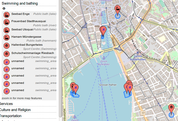
There’s a new category “Swimming and Bathing” (under “Leisure, Sport and Shopping”) in OpenStreetBrowser.

Screenshot of OpenStreetBrowser showing the "Swimming and Bathing" category

It includes a variety of swimming and bathing facilities:

  • leisure=swimming_area
  • leisure=water_park
  • leisure=beach_resort
  • leisure=sports_centre
  • natural=water, sport=swimming
  • natural=beach
  • amenity=public_bath (it will add the “bath:type” in the description)
  • tourism=spa_resort
  • leisure=swimming_pool (only those, which don’t have “access=private” set)
  • leisure=sauna (it will add the “sauna:type” in the description)

If you have ideas for improvements, you can post ideas on the Github issues page.

Posted by velmyshanovnyi on 29 November 2018 in English. Last updated on 30 November 2018.

The Ukrainian community is concerned about the possible negative impact on the project as a whole, the emergence of lawsuits from users of data and the subsequent decline of the project, and therefore restores the borders of Ukraine to the internationally recognized status. The recent decision of DWG ( https://wiki.osmfoundation.org/wiki/Working_Group_Minutes/DWG_2018-11-14_Crimea ) neglects the wide recognition of Crimea as an integral part of Ukraine expressed by numerous governments and international organizations (in particular, UN General Assembly Resolution 68/262 http://www.un.org/en/ga/68/resolutions.shtml / https://undocs.org/en/A/RES/68/262 ). DWG actions directed to cut off Crimea from the borders of Ukraine are considered to be inadequate to the interests of the project and are not recognized by law. Any blockages (bans) aimed against members who restored the border of Ukraine to the widely internationally recognized status will be seen as unjustified pressure on the entire community and usurpation of power in the OSM.

P.S. “changing names or country information would require consensus from both the Ukrainian and Russian communities. It is unlikely that any such edit proposals will be able to achieve this.” (с) DWG //

Moreover, according to clause 4, a consensus should be reached between the Ukrainian and Russian communities on changing information about countries. There is no consensus - there is no reason to separate the Crimea from Ukraine.

CrimeaІsUkraine #DWG #CrimeaMap #КримЦеУкраїна #ИхТамНет

osm.org/relation/60199

See full entry

Location: Shevchenkivskyi district, Kyiv, Ukraine
Posted by pnorman on 28 November 2018 in English.

The Membership Working Group (MWG) has been very busy lately with the roll-out of the fee waiver for lack of money transfer program. Rather than a quarterly update, here’s some news.

New countries

We’ve gotten more information about countries that PayPal doesn’t support and have added Central African Republic, Equatorial Guinea, Haiti, Kosovo, Libya, South Sudan, Timor-Leste, and Uzbekistan to the list of countries which qualify because there’s a lack of suitable money transfer facilities.

If you have information about countries not on the list at https://join.osmfoundation.org/fee-waiver-program/ where PayPal is not supported or the cost of transferring money is more than the cost of membership, please contact the MWG at membership@osmfoundation.org.

Application statistics

We welcome and congratulate our 19 new members from Iran, Kosovo and Liberia who have already joined the OSMF through the fee waiver program.

Over the first seven days, we had 45 applications. All the percentages below are based on these applications, and are rounded. The pace is still continuing, and as we work on our processes, it will be possible to automatically generate some statistics. Right now it’s manual, so I don’t have more recent numbers.

The money transfer applications are easy to deal with, as we have a well defined process. They only take a couple of minutes when all the information is there.

Of the first 45, 60% of the applications are from Iran, and 5% from Liberia, both countries on the list where money transfer is not practical. The remainder are from countries where we’re seeking more information from the applicants. Since the first seven days, we’ve applications from other countries.

25% of applications filled out the form incorrectly and were asked to fill it out again with a corrected username. We might need to look at providing more instructions on the form.

How can I help?

See full entry

Posted by combloop on 28 November 2018 in English.

I’ve just finished mapping Hackensack today, the most populous city in Bergen County. No place has taken a longer time so far except for Paramus, which has more than twice the land area.

A few parks were missing, but I found them through hackensack.org/recreation. I noticed how a lot of the parks were named after a street that passes right by them, which I found to be somewhat interesting.

While mapping Hackensack, I made it to 600 edits. I had made a lot of edits in Hackensack!

Hackensack is an example of what I like to see in a city. There’s great diversity when it comes to neighborhoods. There’s a downtown that’s one of my favorites, right next to some pretty nice residential areas.

I don’t know what I will do next. I will start editing in other countries now, but my mapping in Bergen County will still be my priority!

Below is a link to Hackensack on the map.

Location: Hackensack, Bergen County, New Jersey, 07601, United States
Posted by mikelmaron on 27 November 2018 in English.

Wonderful story about the OpenStreetMap India community on the cover of Bangalore’s largest newspaper.

A decade ago Schuyler and myself were invited to share OpenStreetMap across India. I documented that life changing trip. It was a significant launching point event, but was not the start of the OpenStreetMap community in India however – Arun Ganesh, Shekhar Krishnan and others were already well on the way. And certainly all credit for what’s developed since goes to the folks mapping every day.

For me personally, it was a lifelong highlight of my career. As well, it was also a significant personal launching point. And probably for OpenStreetMap as a whole. Later that year we helped Palestinians map the West Bank. The next year, we initiated Map Kibera. All of these experiences contributed to the formative moments of Humanitarian OpenStreetMap Team.

See full entry

Posted by Glassman on 27 November 2018 in English.

There is one Search Engine Optimization (SEO) company that keeps adding incomplete data in the US. They never respond to inquires or fix their errors. They add duplicate nodes, use the wrong syntax for opening_hours, leave a lengthy description and never tag the type of business.

Looking at their history two things stand out. First their locale is either en:US or en:GB. Could be two different locations or more likely different users. The other is when they make their edits. Below is a breakdown of their edits since Jan. 1, 2016 :

UTC Hour Edits

SEO Edits

Changeset timestamps show that edits start around 04:00 and end before 14:00. My guess is the location is 3 to 5 hours ahead of the UTC. Anyone want to venture a better guess?

Having the IP of the users to get a better location would be nice. Anyone with OSM system admin want to assist?

Power substation Infrastructure cartography is the main topic I’m involved in in OpenStreetMap and certainly one of many good reasons of why such a free project is valuable nowadays. It’s really useful to get such data as a professional, to work for many network rollout or operation company. It’s also important as a citizen, to get a better understanding of how a city or our own district actually breathe or get fed by its different man made supplies. Everyone is able to more and more use OSM to get many other data than the road network which was the main initial proposal of the whole project.

I’ve been contributing to OSM for seven years now, both on the field to edit the map in the places I went and for the tagging model also. The last is literally the key to empower people to collect relevant information from any sources. I feel the need to sum up here rich discussions, interesting collaborations and the challenge the community achieve right now.

How OSM helps in infrastructure knowledge?

See full entry

Location: Vigy, Metz, Moselle, Grand Est, Metropolitan France, 57640, France
Posted by NunoMASAzevedo on 26 November 2018 in English.

On November 26th, the Sports Technician course had the opportunity to receive training in JOSM, under the Erasmus+ European Youth Humanitarian OpenStreetMap project (https://twitter.com/euYoutH_OSM). The graduates of this course have learned how to design buildings, properties and to label structures yet to be mapped. This was the first of many mapping meetings in OpenStreetMap, led by teachers Elizabete Oliveira and Nuno Azevedo. (https://pbs.twimg.com/media/Ds9t7d8WoAEOKl-.jpg:large)

Location: Sé, Angra do Heroísmo, Azores, 9700-032, Portugal
Posted by NunoMASAzevedo on 26 November 2018 in English.

On November 23rd, some ESJEA teachers began their training in OpenStreetMap in a session guided by teachers Nuno Azevedo and Elizabete Oliveira. Under the Erasmus+ European Youth Humanitarian OpenStreetMap project, some teachers worked with the Java OpenStreetMap, putting Terceira Island more and more on the map. Other sessions will take place in the future, with the intention of exchanging ideas, improving techniques and creating maps for the world’s places that do not have it. (https://pbs.twimg.com/media/Ds9pBooWwAAy_kr.jpg:large)

Location: Sé, Angra do Heroísmo, Azores, 9700-032, Portugal

(following on from this diary entry)

Supposing you would like to overlay a set of boundaries over the top of any existing map style - what would you need to do?

Using this as a reference, create a database to hold the new boundary data.

If a historical data file is what you want, download the data for the desired date and rename it to a file name that the “update_boundaries” script will recognise:

-rw-rw-r--  1 renderaccount renderaccount   459723464 Nov  2 01:46 ukraine_2018-11-01T21:14:02Z.osm.pbf

You can also make other changes to this data if you wish using tools like osmium, osmfilter, osmosis, etc.

Modify this script to process your data.

Run the script to load the data that you have already downloaded:

sudo update_boundaries.sh current

Create a version of “mapnik.xml” (or whatever style file you are using) that looks in the database that you’ve loaded your boundary data into. In this case I just changed “dbname” references from “gis” to “gis3”.

Ensure that “/usr/local/etc/renderd.conf” knows about the new tile layer. The default one I use just has “ajt” in it; I created a copy of the last section, called it “ajt3” and changed URI and XML values.

[ajt3]
URI=/hot3/
TILEDIR=/var/lib/mod_tile
XML=/home/renderaccount/src/openstreetmap-carto/mapnik3.xml
HOST=localhost
TILESIZE=256
MAXZOOM=20

Restart renderd and apache2, and your new tiles will appear. Then in a simple Leaflet map add an overlay layer for your new tiles. This is an example that shows Leaflet overlays but there are many, many others, including on the main Leaflet site itself.

Here’s what it looks like:

See full entry

Posted by Kilkenni on 25 November 2018 in English. Last updated on 26 November 2018.

No politics. So neutral.

Several hours ago three Ukrainian ships were attacked, shot and captured by Russians in Black Sea. Currently there are around 6 wounded on Ukrainian side. Ukrainian government considers declaring martial law. Make no mistake, we face war.

@SomeoneElse, Andy, stop changing the borders of Ukraine. I don’t care any more what you can possibly say. From now on, you are an accomplice. Stand down and leave DWG before you disgrace yourself, us and the project even more.

I call to DWG to publish a transcript of the vote on Crimean “resolution”. We need to know our heroes.

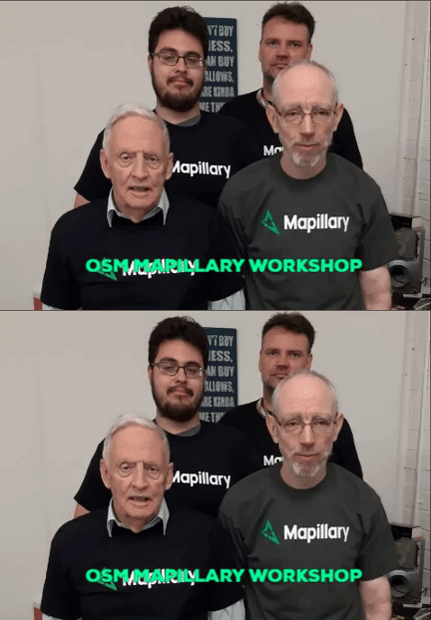
I was asked to do a workshop on mapillary yesterday by the OSM community.

I delivered some slides to kick off. These are here I was focussed on discussing how best to manage the mapillary app on an android device.

Two of the teams

At the end of the talk we went walking after breaking into groups of 2 and heading out with our phones held high. We decided simply to walk around the blackpitts area of Dublin and capture some of the uncovered areas. In general main roads in Dublin have a high chance of some coverage, but when you look at side streets and a lot of residential roads there simply isn’t the same level of coverage.

See full entry