Diary Entries in English

Recent diary entries

Posted by nyampire on 14 June 2018 in English.

Japanese famous (prank and imaginary *note) university “Shinsyu University of International” announces they have switched their access map to OpenStreetMap. It shows their campus in interactive map.

It was reported via twitter, and I have checked if it causes vandalism or something worse.

But curiously, there are no such a campus data on osm.org.

As checked html source of the page, I found they built their own map instance. From their html,

OSM本家に負荷をかけないよう、またまぜか国際信州学院大学が表示されない(おそらく知名度不足)ので12以上でズームしていてキャンパスの近くなら自前の地図で表示

In order to avoid harm to OSM website, and due to OSM does not show “Shinsyu University of International” in their map (Probably we are not so famous), so render our map if zoom level upper 12 and near the campus.

Nice joke, I’m tricked :)

*note: SUI claims they are REAL university.

The OpenStreetMap Navigation map is a web application which uses Mapillary vector layer to highlight the traffic signages detected in Mapillary images. The application is helpful to add/verify/modify turn-restrictions on OpenStreetMap.

Using the navigation map, our team and the community reviewed 38,658 turn restrictions signs from Mapillary, out of which there were 18,565 valid, 11,924 redundant and 7,989 invalid turn restrictions.

We’d like to announce Mapbox will no longer maintain this tool and will no longer work from today. This is an open source project, if you’d like to run a similar project or re-use this, you can find all the information in the repository. Thank you to all the contributors!

Hello Human!!

I am working on my GSoC project, that is providing support for vector tiled data in OSM iD editor, for about a month now. Initially, there was a lot of reading about how the map is rendered on a screen from geojson data, how are raster tiles and vector tiles different, various formats of vector tiles and much more!!

First step in the project

See full entry

Location: Manglaur, Roorkee, Haridwar, Uttarakhand, 247656, India

I have been happily adding rural roadways to OSM for a few years now. Recently, another user has been systematically retagging/reclassifying many of the roadways I have originally added to the database, essentially flattening multiple types of road into a single type of road (changing secondary, tertiary and unclassified roads into all tracks).

It wouldn’t bother me so much if the other user was helping to fill in unmapped areas, but it seems all they are doing is chasing and changing my work.

The user did not attempt to contact me to ask why I tagged things the way I did, so I contacted them and explained my reasoning and asked if we could come to an agreement.

The response was simply to tell me I was wrong and to point me at specific OSM wiki pages. When I quoted sections that agreed with my tagging methods, I was still wrong.

The other user even opened a forum topic to specifically point the finger at me and say I was doing things the wrong way, and to ask others their opinion. A step in the right direction, except the user ignored comments that agreed with my methods and took any that agreed with theirs as total validation.

Let me point out that neither of us is technically wrong, according to information on multiple wiki pages.

As a result of the discussions, I have changed the way I tag rural roadways and have clearly stated my methods on my profile page. I have explained my reasoning in direct messages and on the forums, but this other user persists in changing my original work.

Have any of you run into an issue like this before, and were you able to resolve it?

At Mapbox we are happy to open source RoboSat our production ready end-to-end pipeline for feature extraction from aerial and satellite imagery. In the following I describe technical details, how it will change the way we make use of aerial and satellite imagery, and how OpenStreetMap can benefit from this project.

Berlin aerial imagery, segmentation mask, building outlines, simplified GeoJSON polygons

See full entry

Posted by geos1440 on 11 June 2018 in English.

Marked the Burrinjuck Dam tramway, a 2ft narrow gauge line created to service the construction of the Burrinjuck Dam. The line ran from Goondah to the dam construction site. Although the track was lifted in 1929 the line is easily traced in the NSW LPI aerial imagery and the right of way appears on the NSW LPI topographic maps.

The line has been traced as far as the Burrinjuck rd / Page st intersection. Beyond that point the Dam access road has razed the line.

Location: Clanmara, Bowning, New South Wales, 2582, Australia

Ann and I drove up to Nohur, an ancient Turkmen village she had not yet seen. Alexander the Great came through here a couple of thousand years ago and left some of his legion behind. They settled in Nohur and their descendants are still here, some still with green eyes inherited from their Greek forebears. The village is famous for its watermelons so we bought one. While there I recorded the names of two of the three cemeteries not yet mapped and have now added them to OSM. I have to wonder how many of Alexander’s soldiers are buried in them!

When the Mapillary images are uploaded (currently in progress) you can see some of the headstones, which are decorated with ram’s horns. Nobody seems to remember exactly why, but it is apparently a custom left behind by the Greeks.

On the return to Ashgabat, we stopped to explore Durun, a typical former Soviet state farm village. It is small so we recorded every street name in the village represented on a street sign (not all streets had signs), plus some POIs. My embassy has published six American books in Turkmen translation so we gave books away to the villagers as we drove around collecting cartographic information. Word spread and at times we were mobbed by children wanting their own copy of “Harold and the Purple Crayon” in Turkmen. All in all it was a very enjoyable Sunday.

Tomorrow we’ll start eating the watermelon.

Location: Nohur, Baherden District, Ahal Region, Turkmenistan

As of the last upload of images from a trip across the Karakum Desert to the city of Dashoguz, and visits to sites in and around Dashoguz, I have contributed a bit more than 200,000 Mapillary images, the vast bulk of them in Turkmenistan and the vast majority taken in areas where nobody else had captured ground-level imagery to that point. I hope some of you will take the opportunity to visit Turkmenistan virtually via Mapillary, since Turkmenistan issues only about 11,000 tourist visas per year and is one of the least visited countries on the planet There are some marvelous sights, however! I’m trying to capture as many as I can.

Somebody vandalized streets I had drawn in Awaza, the resort zone on the Caspian Sea shore. He (yes, it was a male of the species) disconnected streets and moved them around, then added nonexistent streets. I don’t understand why someone is motivated to vandalize a map database. It is all repaired now, but repairing the damage cost me time I could have spent doing something else.

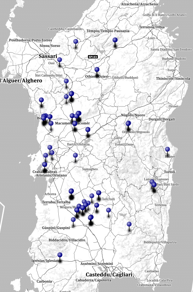
As part of the #cittasenzamemoria project, the verification of toponyms dedicated to Vittorio Emanuele III in Sardinia was updated.

Sardinia

The data comes from the map of OpenStreetMap aimed at creating a free content cartography of the world. The map information is freely accessible under license ODbL and updated every day. To facilitate the consultation, the toponyms are also available on the dedicated online map. A total of 39 names were identified below:

id name City

See full entry