Diary Entries in English

Recent diary entries

Well, It seems that political and administrative boundary in Indonesia is missing in level greater than 4

According to Tag:boundary=administrative, here in Indonesia we divide administrative boundary into 10 as following:

  1. N/A
  2. National Border
  3. N/A
  4. Province
  5. City / Regency (Kotamadya / Kabupaten)
  6. Subdistrict (Kecamatan)
  7. Village (Kelurahan / Desa)
  8. Hamlet (Dusun)
  9. Community Group (Rukun Warga)
  10. Neighborhood Unit (Rukun Tetangga)

for anyone concern about regulation / legal or law, this boundary is SHOULD be provided by BIG, Badan Informasi Geospasial, a national body for geospatial information. You can download their official “peta” (it’s map in Bahasa) from their website, NOT!

Well, it’s not their fault … I’ve heard that they “lack of cost”, it’s actually lack of funding … but as THE ONLY OFFICIAL BODY in Indonesia who has authority to publish administrative boundary, they should concern more with their tax payer money … aren’t we?

God bless Indonesia …

Location: Langgini, Bangkinang Kota, Kampar Regency, Riau, Sumatra, 28411, Indonesia
Posted by azsr on 16 December 2017 in English. Last updated on 11 February 2018.

Today, I mapped out the R Line in Providence and Pawtucket. Since I found it so enjoyable, I decided that I’m going to try to map out all the RIPTA bus routes (eventually).

As a starter, here’s some of the routes already in the system:

Probably fine

Still need bus stops and platforms.

Needs conversion

Most of these have the one relation running both ways.

Overpass

Here’s the Overpass QL script I’m using for getting these routes:

[timeout:25];(relation[“route”=”bus”][“operator”=”RIPTA”];relation[“route_master”=”bus”][“operator”=”RIPTA”]);out meta;>;out meta;

next entry

Quite a subject, I know, so please let me explain my feelings.

There’s a news story that “Facebook admits it poses mental health risk”

The story includes a previously reported comment from an ex-Facebook executive saying: “The short-term, dopamine-driven feedback loops that we have created are destroying how society works. No civil discourse, no cooperation, misinformation, mistruth.” In my opinion this applies directly to OSM provided resources, specifically the mailing lists.

Now, people will say straightaway “I’m not on Social Media, I don’t do it; I’ve done emails since before you were born. Facebook is stupid and listserv is how we do it”. The point is, many OSM provided services, including the mail lists, are, for all intents and purposes, Social Media. People are using the OSM services for the same dopamine hit that they use other forms of Social Media, such as Facebook, Twitter, Instagram. The difference is we don’t share photos of our lunch on the mailing lists. The end result, however, is the same; No civil discourse, no cooperation, misinformation, mistruth.

I am a long term subscriber to 3 OSM mailing lists (talk, since 2009, I think; HOT since day 1; OSMF-talk since 2012) and all three have recently been dominated by a very small group of people engaging in the short-term, dopamine-driven feedback loops described above. There have been examples of racism, bullying, harassment, as well as a number of conspiracy theories and statements made that are bizarre to the point that they have to be outright questioned to make sure we’re all reading the same words. Engaging with these comments only provides an opportunity for another instant dopamine hit, or opens the door for others to engage in the same behaviour. I am unwilling to post any links to demonstrate this; it shouldn’t be too hard to think of recent examples.

See full entry

Location: Abingdon on Thames, Abingdon, Vale of White Horse, Oxfordshire, England, United Kingdom

This tweet inspired me to write a new diary entry.

BHousel does not like the criticism he’s been getting for several years now.

Drawing rectangular buildings using the iD editor is a lot harder than it ought to be.

My opinion is that if you create a tool that is going to be used by thousands of mappers, you owe it to your users to make sure that they can produce quality work with ease. Especially if the effort to do so would outweigh by an enormous ratio the frustration shoddy work creates for HOT’s validators (and (re)mappers using that other mapping tool), who need to put more time into fixing the mess, than they would have actually mapping those buildings themselves in the first place. It’s not like the science of creating a rectangle based on adding 3 points using 3 clicks still needs to be invented.

This is an ongoing problem for many years. So either it gets fixed one day, or frustrated messages will happen to escape, every once in a while. Or they will get muffled and HOT validators will continue to silently give up on trying to fix the deluge of poorly mapped buildings. Or you can simply unsubscribe from HOT’s Twitter feed. Whatever works for you.

A more constructive solution would be to invite other programmers into the project. I can’t imagine there wouldn’t be candidates.

Here’s hoping that something good can come out of this.

Polyglot

Well, I should be proud of living in a country where its internet connections were sucks. Updating JOSM plugins and imagery tiles are nightmare!

But, I eventually found a better way to tackle this awesomeness, with downloading all necessary imagery tiles with SAS.Planet, exporting those tiles into single MBTiles file, then, load those mbtiles file into JOSM with MBTiles plugin.

Cheer from KAMPAR Regency, Riau Province, Indonesia,

Location: Tarai Bangun, Tambang, Kampar Regency, Riau, Sumatra, 23567, Indonesia
Posted by ke9tv on 14 December 2017 in English.

I’ve been trying to get public land boundaries in New York State tidied to where trail maps will show reasonable results for the parks and forests.

One problem that was recently called to my attention was Camp Smith in Peekskill, New York. Researching this area revealed rather a complex history, and I thought that I had better write this diary entry to explain what I did, since it doesn’t quite agree with any of the ‘authoritative’ data sources.

Camp Smith, purchased by New York State between 1923 and 1940, is a National Guard post, and as such, is State land rather than Federal. The Hudson Highlands State Park that borders it is also, of course, State land, and in fact, portions along the north of Camp Smith had been carved out of it historically to create a corridor for the Appalachian Trail.

On that state land, a trail from the Bear Mountain Bridge to the summit of Anthony’s Nose has existed for a very long time. I know that I visited Anthony’s Nose as a Boy Scout in the late 1960’s. Since at least 1993, there has been a trail open to the public that takes a strenuous course from there southeast along the cliffs, with many fine view overlooking the river. Everyone understood it at the time to be a way along which public access was granted, that traversed the grounds of Camp Smith.

See full entry

Posted by Hemantcompiler on 13 December 2017 in English.

This is the first time I went on a mapping party and that too to Wayanad. I didn’t know much before about what a mapping party is, but I looked up on the internet and realized that we will be learning how to map areas on Openstreetmap and will meet the community and the people contributing to it. Actually if any type of event is happening in Wayanad, you can be assured that you will have a good time. Its such a beautiful place, you cannot miss the chance to at least see it once :)

I asked Praveen sir about how to reach there and we decided to go from KSRTC bus stand from Calicut. The journey from Calicut to sulthan bathery was just mesmerizing, I witnessed the beautiful sunset in the hills from the bus. I was just hoping that the bus get some malfunction and stop there so that I can look at it for a little longer. And you can even see pineapple farms there, they were just beautiful. There were even people selling pineapples on the road sides. I wonder how fresh the pineapples were, its like you can ask them to pluck a fresh pineapple for you!

Also being an open source software user and supporter, to discuss what all is happening in the world is just awesome, It was like feeding your soul. And since we are talking about feeding, the food there has just another level of awesomeness. At first I was reluctant to try the food as I wasn’t sure what it is made up of. Then I tried puttu, and it had no taste, and then they told me that the taste of that depends on the curry. So you better have a good curry!! Puttu mixed with curry tastes delicious, it’s just that I wasn’t able to find the right curry :) A tomato curry would have been the one, I will try that next time. If you are a dosa fan but not much of a fan of potato, then let me tell, there is a thing called “ghee roast dosa”, you should definitely try that and even better is appam. The only thing that I didn’t try was idiyappam and I still think that I should have tried that. I missed the opportunity :)

See full entry

Location: Manthandikunnu, Sultan Bathery, Sulthanbathery, Wayanad, Kerala, 673592, India

Dear All,

I have to apologize for that the study link was broken for couple of days. Bugs are already fixed and the study is work well waiting for your contributions. Please, use study http://hccvgi.informatik.uni-bremen.de/ to help science. Our research focuses on YOU (OSM users) and contributors. Participate in the study http://hccvgi.informatik.uni-bremen.de/ to see how perfect you are in recognizing landuse areas.

Posted by Joicemj on 11 December 2017 in English. Last updated on 12 December 2017.

It was fun mapping Wayanad. A district known for its environment, ethnic people, sensitive areas, Hills, Forests and of course Rain.

For the very first time, J4v4m4n, Pirate Praveen suggested the idea of pirate mapping parties. To be exact, 5 months before, he started a new thread on Loomio as a proposal to contributing to open street maps as Pirates. Later the discussion lead to mapping parties around Kerala. When Praveen completed Kannur, I asked him for one here in Wayanad. Exactly a week before 9th of this month, Praveen told me, we can host on 9th. I got excited as well as nervous. I don’t know what to do, How to arrange accommodation, where to map, etc. I was really worried about bicycles. I thought cycles could speed up the mapping process. Another headache was whom will help us in mapping. Tada.. Ranjith Siji, Mujeeb, Kannan, Ambadi, Tanzeer, Sruthi, Hemanth came up to fulfill our plans.

Next to resolve was accommodation. Sreejith Koiloth helped us to rent DIET hostel.

Into the real fun

Sruthi, Praveen and Hemanth reached Bathery on 8th. Had dinner from Aravind Mess House. And then headed to DIET hostel. We made some plans for the next day. Discussed a lot of things too. On 9th December of 2017, by 8’O clock, Ranjith Siji, Mujeeb, Kannan and Ambadi reached. I picked Tanzeem and we met everybody at NRS bakery, Sulthan Bathery.

As planned earlier, unto noon, we mapped Sulthan Bathery. we grouped by 2. Me, Tanzeem and Praveen became a group. Ambadi and Mujeeb became next, Sruthi and Hemanth, Ranjith and Kannan and so on. By 12.30, We covered Almost bathery. After that we sat on a bench and discussed about the progress. Kannan came up with a digital SLR camera. He made couple of beautiful snaps. ( He haven’t yet shared any of them. I will update whenever I recieve them)

See full entry

Location: Manthandikunnu, Sultan Bathery, Sulthanbathery, Wayanad, Kerala, 673592, India
Posted by ShadowFoxNixill on 11 December 2017 in English. Last updated on 8 February 2018.

Background

As I write this, a complete overhaul to SMART/DDOT relations is being uploaded to the server. I did this for two reasons.

Reason the first:

When I last “overhauled” SMART relations, I admittedly made a huge mess of things. There were two reasons I did this:

  1. I thought it’d look nice on the transit map with each route number getting rendered just once per road.
  2. I didn’t want to have to add the bus stops to all the relations and risk forgetting some.

So what I did was made route segments and route segment segments.

I apologize for that, now realizing that it’s wrong. Plus, the second point above is invalid, as I’ve since discovered; I can edit multiple relations simultaneously.

The first reason for this overhaul is to fix that.

Reason the second:

Data for both systems was horribly outdated. For example, there were still bus routes depicted on Woodward south of Campus Martius, which hasn’t been the case since the QLine construction started. The DDOT relations still used the old public transit format! So the second reason for this overhaul is a data update.

Caveats

There are a lot of bus routes I haven’t ridden:

  • Almost all DDOT routes outside of Downtown
  • SMART routes 160, 280, 445, 475

For these routes, I’ve put my best effort to mapping them accurately, though in some places I simply could not tell where the route was intended to go (see: 38 at Harrison, Sears, or Outer Drive).

Sources

Official bus schedules and maps can be found at DDOT, SMART, and RTA. Additionally, for the RTA and SMART routes, some details not shown on the maps were mapped from personal experience.

For some DDOT routes where I couldn’t tell what was what on the map, I followed roads that were part of the pre-existing relations.

I also used a bit of OpenStreetCam data to figure out which way buses went around loops.

Lastly, DDOT’s GTFS file is public-domain, and helped me figure out a couple things as well. It can be downloaded here.

What’s next

See full entry

Posted by Tordanik on 10 December 2017 in English.

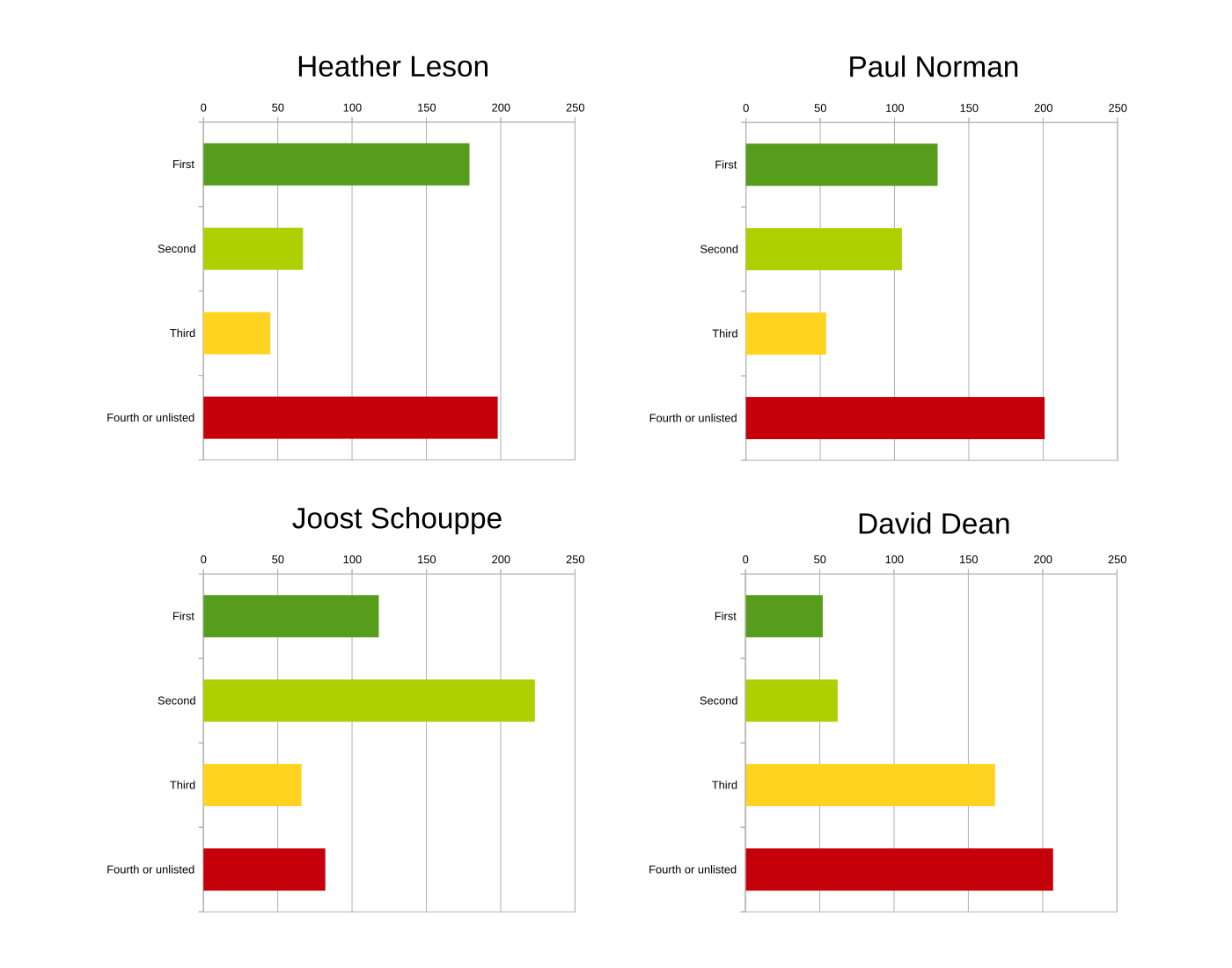
The anonymized ballots from yesterday’s OSMF board vote are available as a handy text file on OpaVote, so I decided to play around with them a bit. Here’s a breakdown of the rankings for each candidate:

Heather Leson (1: 179, 2: 67, 3: 45, 4: 71, 0: 127), Joost Schouppe (1: 118, 2: 223, 3: 66, 4: 34, 0: 48), Paul Norman (1: 129, 2: 105, 3: 54, 4: 50, 0: 151), David Dean (1: 52, 2: 62, 3: 168, 4: 64, 0: 143)

I was also curious if people usually filled in the maximum of four slots, or left some of them blank. This is the result:

  • 0 candidates: 11
  • 1 candidates: 21
  • 2 candidates: 124
  • 3 candidates: 114
  • 4 candidates: 219

So most people did indeed list 3 or 4 candidates! With STV, the third place can matter even if there are only two seats available, so it makes sense to fill it in. Nevertheless, I also looked more closely at the top two spots to see if there are any interesting correlations. Based on all ballots with at least 2 candidates, here’s the popularity of top two pairings (the order of candidate names carries no meaning):

  • Heather/Joost: 166
  • Paul/Joost: 136
  • Paul/David: 46
  • Heather/Paul: 43
  • Joost/David: 33
  • Heather/David: 33

See full entry

Location: Lüfteneck, Sieglgut, Passau, Bavaria, 94034, Germany
Posted by Heather Leson on 10 December 2017 in English.

Thank you to all the OSMF members, fellow candidates, board, and outgoing board members. It has been a privilege to consider your priorities for OSMF via questions, notes, and conversations.

We are the community, the map, and the project. The lovely people who make OSM part of their daily flows count on all of us at OSMF to meet the full mandate and the full potential. This means considering, then building on how we might balance the growing, changing needs of the open, global, diverse community.

Over the past few weeks, the questions on the wiki and the conversations on this mailing list have pointed to some potential actions. Converting those requests and ideas into productive working documents for consultation is the next step. There are many people on this list and in the wider community that will contribute if there are healthy spaces and a clear ask. It is up to us in the membership, in the working groups, and on the board to make this possible.

Thank you again,

Heather

Posted by SeverinGeo on 10 December 2017 in English. Last updated on 10 January 2019.

(EN automatic translation below)

Durant la campagne pour les élections 2017 au board de l’OSM, je suis intervenu par trois fois sur la liste de discussion OSMF :

  • ce premier courriel en anglais dans lequel je montre la faible implication de Heather Leson dans OSM depuis 2011.

  • ce deuxième courriel intitulé “ Language, tone and their explanations - why I resigned from HOT US Inc”, rédigé en français et traduit en anglais, pour expliquer le ton employé dans le premier via notamment ma lettre de résignation de HOT US Inc en 2016, que j’ai publié dans mon précédent billet de blog

  • ce troisième courriel intitulé “The history of HOT US Inc governance - not to be replicated in OSMF” qui contient le lien vers un document, lui aussi rédigé en français et traduit en anglais, retraçant les graves soucis de gouvernance dans le board de HOT US Inc pendant la période durant laquelle j’en étais membre (mars 2014 à janvier 2016)


During the campaign for the 2017 elections on the board of the OSM, I spoke three times on the OSMF mailing list:

See full entry

As just stated on the Fossgis Hackingweekend at the Linuxhotel in Essen… “I’m mapping the year of constrcution for a (huge) number of houses. I’m looking for a way to visualize this on the map”.

Likely multiple solutions exist, but how to do this with libosmscout?

At the start of the weekend this was not yet possible. Small discussion with another developer (not at the weekend) showed, that a general approach was needed, as colouring of ways based on attributes has also interesting use cases (hint: colour of metro lines).

Libosmscout implements tag and value combinations as features. All possible features of an object type (configurable during import) are flag in a bit set, if an concrete object has the feature.

The value of an feature is implemented as simple class that must offer serialization and deserialization methods.

So first we write a new Feature implementation that parses the start_date and year_of_construction tags. The new Feature will have two int attribute for the start and end year. Investigation of the actual tag values show and creation time can be an time interval, for our needs the year however is enough. Depending on the use case other implementation could be possible, too.

We need to do some string parsing to get most of the possible variants of the tag values parsed. Mapper: Please do not be to creative ;-)

Afterwards we add the possibility to register style processors into the rendering pipeline. The processor has a simple interface. It gets the list of feature values and the style as defined by the style sheet. It returns either the original style or a (cache) new style instance. Processors are registered by type.

Next step is to implement a simple processor for the type building. The processor checks if the construction year feature is available and the year between 1800 and 2020. In this case it return a red fill style, with the actual brightness depending on the age. Older buildings get darker red.

See the result:

See full entry

Location: Horst, Stadtbezirk VII, Essen, North Rhine-Westphalia, Germany

Hi all :)

My name is Dorothea. I’ve been helping the OpenStreetMap Foundation board and some of the Working Groups in the past year, as an Administrative Assistant (one of two independent contractors that the Foundation has - the other one being the accountant). So, for transparency reasons I would like to give you a better idea of what I do and also my view of what being at the Board encompasses - based on my experiences from the previous year.

What I do

Basically I am helping the board (and some of the Working Groups, if there is time and they want to) with administrative tasks, so they can have more time to focus elsewhere. So far I am mainly involved with:

Some non-regular tasks:

  • Administrative support during Local Chapter applications
  • Adding Advisory Board members to the AB mailing list and updating the wiki
  • Providing membership lists

Infrequent:

  • Documenting Local Chapter Congresses (2016, 2017)
  • Documenting the Face-to-Face meeting (2016 # on the board wiki)
  • Implementing the new Corporate Membership Payment system on CiviCRM (2016)
  • Running the Election to Board (2017)

Two Working Groups have asked for administrative support from the board

  • Licensing Working Group: Documenting online meetings
  • State of the Map Working Group:
    • SotM2017 - Supporting scholars
    • SotM2018 - (Plan for) Supporting scholars (if there is going to be a scholarship program) and sponsorship

Time allocation

This can vary from month to month, with a cap of 65 hours per month. This was surpassed at least once before State of the Map 2017, as one of the scholars required extra support in order to get his visa (there was no Embassy of Japan in his country).

An overview of the time allocation is supplied monthly to the board. I also have a monthly meeting with the Secretary.

An inside view of the Board’s work

See full entry

When sitting down to write the Chairperson’s Report for this Annual General Meeting of the OpenStreetMap Foundation I have to confess I was having a difficult time. Not because OpenStreetMap hasn’t continued to make great strides over the past year and continue to become further THE free map of the entire world. No, it was because my heart once again was heavy. This year’s election has been even more hostile than others. Some of the debate has surrounded around if OpenStreetMap is currently a welcoming place for all and if we ever make people not feel welcome due to the actions of some of our members.

Procrastinating on writing this I was scrolling through Twitter and I happened across a quote from the CEO of Creative Commons, Ryan Merkley.

“Pick big fights with your enemies, not small fights with your friends.”

Stop and think about that for a moment.

When OpenStreetMap started we picked a huge fight with proprietary map provides. For a long time we were just some little upstart, but then they began to take us seriously. Today we continue to be used in more prominent and more important ways all over the world. Just in the past 2 weeks OpenStreetMap became used in Ingress and Pokemon Go, applications of millions of users. New editors are coming in because they can update the map themselves. How exciting is it that all our work continues to be used in more and more ways?

What is our next big fight to continue to be the best free map of the entire world? Let’s all think about those challenges and how we are going to surmount them.

How can we lay aside differences and be welcoming to people who are different from us? It is certainly not from fighting amongst ourselves. That just makes people want to check out, myself included, hence the difficulty in writing this report.

See full entry

Location: Winlock, Lewis County, Washington, United States