Diary Entries in English

Recent diary entries

OpenStreetMap is one of the few open source initiatives that operates without a formal Code of Conduct. Many [1] of the large open source projects have adopted a Code of Conduct for their mailing lists, forums and conferences.

Why would we want to have a formal standard for contact? OpenStreetMap longevity depends on our being able to attract and keep new mappers, developers and third party users. Good behavior means more people feel comfortable engaging in community discussions. Bad conduct not only drives people away but can lead to giving OSM a bad reputation. Our reputation is key to raising funds needed for operation and growth. The OSMF Board has a fiduciary responsibility to protect our project. Adopting and enforcing a Code of Conduct is a step in that direction.

[1] Some examples of CoC guidelines are:

  • Be respectful
  • Be friendly and patient
  • Be civil and considerate
  • Be collaborative
  • Assume good intentions.
  • Respect time and attention
  • Disclose potential conflicts
  • Take responsibility for our words and our actions
  • Be welcoming
  • Be careful in the words that you choose
    • Discriminatory remarks based on stereotypes
    • Violent threats or language directed against another person.
    • Discriminatory jokes and language.
    • Posting sexually explicit or violent material.
    • Posting (or threatening to post) other people’s personally identifying information (“doxing”).
    • Personal insults, especially those using racist or sexist terms.
    • Unwelcome sexual attention.
    • Repeated harassment of others. In general, if someone asks you to stop, then stop.
    • Deliberately spreading FUD (Fear, Uncertainty, Doubt)
    • Advocating for, or encouraging, any of the above behavior.

Adopting a CoC is just one step in the process. If we only post the CoC when members sign up on a mailing list or attend our conferences, nothing will change. Instead the Board should:

See full entry

Location: Mount Vernon, Skagit County, Washington, 98273, United States
Posted by Zainab Sengeri on 1 December 2017 in English.

Hi mappers ! I am happy to be one among youth mappers who contribute in mapping different part of Africa. mapping helps a lot, especially when it comes about saving affected people of specific area. In other words I can say that mapping area helps to reach them easily.I started mapping since June of 2017. I have mapped more than 100 buildings and some high ways of course.

Location: Kilombero, Morogoro Region, Coastal Zone, Tanzania
Posted by SeverinGeo on 1 December 2017 in English. Last updated on 10 December 2017.

Here is the letter of resignation that I had sent to the HOT US Inc members on May 5, 2016 (more context can be found in my next diary entry):

Hi,

I hereby resign from as a HOT US Inc member with immediate effects.

Some recent members may not know me, but I have been active in HOT US Inc, as well as other OSM projects for more than 5 years ago now, both in remote activations, training and field work over more than 20 countries.

My main motivation is that HOT US Inc, despite its storytelling, is not a community driven project, it is a just a very classic Corporation run by a board whose aims are far from openness, truthfulness and respect of differences that should lead an OSM project involved in humanitarian and development fields. And as I do think it even represents a real danger for OpenStreetMap, I do not want to endorse and be in collusion with it. Considering how much I worked to make HOT US Inc successful in some ways, I let this organization totally sickened by what it became. I guess I am not the only one: some huge contributors have already silently stepped out for the exact same reasons.

The triumvirate that quickly emerged within the native English speakers from the 2015 board made the meetings a real pain for a non native EN speaker like me. Talking as fast as they can, which does not allow you to catch everything as you would like or quickly enough to everything that is implied by the decision to make. Not agreeing with them and sometimes opposing their views means disrespectful behaviors being frequently cut when you try to express yourself in their native language, your past contribution totally diminished, your ideas sometimes qualified as ridiculous and every time of the reproach the meetings are unpleasant because of you.

See full entry

Posted by Komяpa on 1 December 2017 in English.

OpenStreetMap.org tile rendering operates on edge of its capacity. It’s possible to get more from already existing cluster if rendering queue is not continuously dropped, but instead is preserved and processed during low load hours.

Ttile.OpenStreetMap.org uses mod_tile and renderd to manage rendering queue. mod_tile is currently a core ecosystem project lacking an active maintainer for years. There are currently 19 Pull Requests that nobody merges.

I tweaked values in source code to allow for a longer queue. Pull request is available at https://github.com/openstreetmap/mod_tile/pull/152. In comments there was a proposal to make it a configurable parameter.

I offer 50 USD to person who manages to:

  • create pull request to mod_tile/renderd that makes queue depth a configurable parameter, and set defaults to preserve the queue to shift day’s load to night;

  • get it depolyed to tile.openstreetmap.org adjusted accordingly.

Shift should be visible on https://munin.openstreetmap.org/openstreetmap/render.openstreetmap/renderd_queue.html graphs, most likely by Dirty queue growing beyond 1000 tiles per server, and being non-empty for the whole day, shortening during the nighttime.

This should make the map browsing experience better for everyone.

See full entry

Posted by abejorro34 on 1 December 2017 in English. Last updated on 3 December 2017.

Example of use at mountain relief modified by mining and agriculture

Lidar (light radar) is a technique providing a very precise surface scanning. Airborne laser scanning generates a dense point cloud (several points per square metre) representing reflections of light ray. It contains reflections as from the vegetation as from the surface under it. Vegetation and building reflections may be filtered to get relief data only and create a digital elevation model (DEM) of relief. It is usually a raster and each pixel value represents the relief elevation. This raster may be further processed for better visualisation of relief shapes:

  1. Hillshade raster – grayscale 3D visualisation,
  2. Slope raster – colour represents the rate of change of elevation,
  3. Aspect raster – colour represents the downslope direction.

Surface irregularities cause by human activities are clearly recognizable in the high-resolution DEM obtained from Lidar.

See full entry

Posted by Rovastar on 1 December 2017 in English.

The popular game Pokemon Go now (Dec 1) is using OSM for the base map in the game for (all) the world.

Expect to get a massive increase in the users registering and editing OSM in the coming days/weeks.

Things to look out for:

People adding new roads and paths. People editing/deleting existing roads and paths, especially the small driveways, etc as they lump the mall together in their rendering and look ugly and cluttered so I expect people will be changing these to the wrong type or deleting them altogether so they can veiw there map

So roll up and begin casting an eye on the swarm of edits.

I, for one, welcome our new Pokemon editor overlords..

  • This article gives me a vision of a map, dynamical rendered with the details, I need just now.
  • That should be possible by vector tiles and client side rendering, using WebAssembly.
  • The autor says: This article stems from my work at www.Mapfit.com - a nice tool. I think they use OSM data but don’t have any note to OSM :-(

https://blog.prototypr.io/mapping-the-reality-of-the-world-df7ad81ccb54

MapFit example

In 2017, despite the current level of influence that the US NGO “Humanitarian OpenStreetMap Team US Inc” (aka HOT US Inc) has over the OpenStreetMap Foundation (OSMF) thanks to Kate Chapman and Mikel Maron (both OSMF Board directors), Heather Lesson, another former HOT US Inc Board Officer and one of its former President is running for the OSMF Board.

Since 2015, HOT US Inc, is the only organization of the OpenStreetMap ecosystem represented at the OSMF Board with two Directors: Kate Chapman (co-founder / former Board member / former Executive Director; elected at the OSMF Board in 2013) and Mikel Maron (co-founder / former President / actual Chairman of the members; elected at the OSMF Board in 2015).

This state of things provides HOT US Inc with more power of influence over the Foundation than any other organizations which is without precedent in the history of this institution. Consequently, this diminishes the representation of the OSM diversity at the Board of the Foundation.

Extending furthermore this HOT US Inc presence and influence at the OSMF Board and shrinking accordingly the room for the diversity of other perspectives around OSM to be represented in this Body of the organization would be a matter of concerns in terms of : - balance of powers between organizations - diversity of visions, thoughts and practices (including internal democracy and conflict of interests) around OSM - board dynamics: a collective of HOT US Inc Boardees would interact with single individuals

With these above risks in minds, given HOT US Inc current influence, its members (aka “hotties”) would be best advised to support the OSM project at the Foundation outside of the Board through its Working Groups to start with allowing “hotties” to get acquainted with another organization. This would mitigate risks of power games, lower tensions and strengthen OSM diversity by saving room for other perspectives and experiences around OSM to be represented at the OSMF Board.

See full entry

Dear participants,

Thanks to the folks who already participated in the study. We are computer scientists concerning with human cognition influence on data classification of voluntary geographic contents like OpenStreetMap. To participate in the study (it takes 25-30 min) press here

The Study consists of 4 steps:

See full entry

Posted by Anxhelo Lushka on 27 November 2017 in English.

I have spent two or three days now and have mapped a large part of Student City using correct data provided by the Municipality of Tirana and applied as a background layer to make my job easier. I am pretty happy with the results so far, have added around 2500 buildings, many businesses based on pictures I took while biking and I intend to map at least 90% of that area part of Tirana.

After seeing a before and after comparision I just love the final results, you can notice how dense that part of the city is now even compared to the city centre (still a LOT of businesses missing from the map, but I’ll make sure to add some more too in the upcoming days).

Posted by Jennings Anderson on 27 November 2017 in English. Last updated on 28 November 2017.

SOTMUS Logo

At State of the Map US last month, I presented my latest OSM analysis work. This is work done in collaboration between the University of Colorado Boulder and Mapbox. You can watch the whole presentation here or read on for a summary followed by extra details on the methods with some code examples.

OpenStreetMap is Constantly Improving

At the root of this work is the notion that OSM is constantly growing. This makes OSM uniquely different from other comparable sources of geographic information. To this extent, static assessments of quality notions such as completeness or accuracy are limited. For a more wholistic perspective of the constantly evolving project, this work focuses on the growth of the map over time.

Intrinsic Data Quality Assessment

See full entry

Location: Goss-Grove, Boulder, Boulder County, Colorado, 80309, United States
Posted by loai_84 on 27 November 2017 in English. Last updated on 28 November 2017.

Dear participants,

Thank you for helping science and supporting voluntary geographic contents. The contents which have been exclusively collected by voluntary efforts. In these contents, public with local knowledge is the main source of information. Thus, we are (as a computer scientist) concerning with human cognition influence on data classification. To participate in the study press here

See full entry

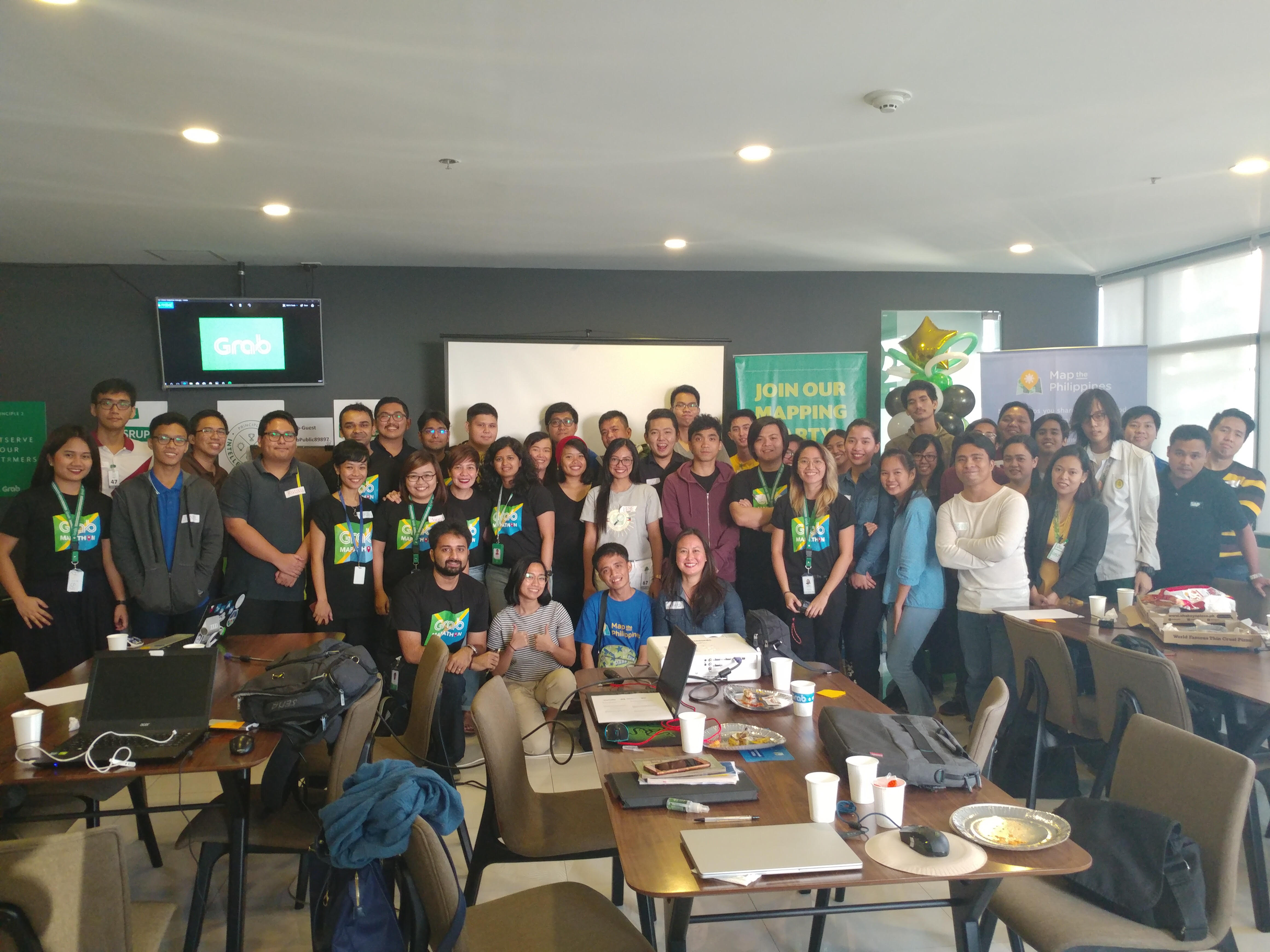
In celebration of the Geography Awareness Week, Grab, Map the Philippines and OpenStreetMap Philippines co-organized a mapping party to teach people how to map, and meet other mappers. It was held at Grab PH’s headquarters in Makati and was attended by volunteers, students, government employees, NGO workers, and Grab personnel.

OSMGeoWeekPH

Celina Agaton talked about the objectives of the mapping party and also introduced her organization, Map the Philippines.

It was followed by an introduction to OSM and Tasking Manager by David Garcia.

See full entry

Posted by contrapunctus on 26 November 2017 in English.

For some reason, I’ve moved to using OSMand instead of OSMtracker+JOSM for adding POIs. It’s just so quick and immediate, and doesn’t require me to remember or guess about anything. (well, for most part; I tried Vespucci a few times, but it’s not nearly as simple and quick).

I did wish OSMand could put multiple POIs in the same changeset, though. It added each POI into its own changeset. There is this checkbox to close the changeset, and it seems to be there for adding modifications to a POI to its previous changeset.

…or so I thought until today, when I saw my changeset history for the first time since I started editing in OSMand. Oh. My. God.

Once again in my time with OSM, I wish I could modify my changeset comments x-P

Posted by ChristianA on 26 November 2017 in English.

Yesterday morning I went on a short bike trip. Since the mountainbike conditions are not very good at the moment, I took a ride on my cyclocross bike. As the temperature had been a few degrees below zero, the gravel roads were perfect (like sandpaper glued to concrete!) so the ride was very enjoyable.

The "Slag cape" in Stavsjö

I checked out a few paths and small logging roads that I had not mapped before. I also visited “Slaggudden” (meaning “The Slag cape”) in Stavsjö. In lake Stavsjön it is a small piece of land that consists mostly of discarded slag from the ironworks that started in this village in 1666. The ironworks in this small village was the largest producer of cannons in Sweden, during the time of the Swedish empire.

Anyway, I tagged the place as “natural=cape”, though it is not really natural.

See full entry

Location: Björkebo, Stavsjö, Nyköpings kommun, Södermanland County, 618 95, Sweden

I was Google map user, its been 5 years I work for it making new place names and lining roads and now im Local Guided user , but Google map has an old satellite version comes from 2004 especially in my town ! And recentrly stopped for making roads ! , Now I’m OSM user since 2014 but the things I noticed is the acceptable for my changes when you make new place and street OSM accept it quickly, not like Google map it takes 2 week for accepting or not. Im Glad to help with you OSM. And sorry if my English is bad :)

Alt text

Location: Avatika, Batifa District, Duhok Governorate, Iraqi Kurdistan Region, 42011, Iraq

Dear participants,

Thank you for helping science and supporting voluntary geographic contents. The contents which have been exclusively collected by voluntary efforts. In these contents, public with local knowledge is the main source of information. Thus, we are (as a computer scientist) concerning with human cognition influence on data classification. Human perceives things differently.

For example, regarding landuse/landcover classification, we could agree on that a parcel of land is covered by grass or water which is an abstract level of classification. However, whether this parcel is a park, a garden, a cemetery, or even a golf court might be perceived differently. Whether this water body is a pond, a lake or a reservoir likely requires finer measures, geographic knowledge, and particular expertise.

Therefore, we developed a study to understand more about how people perceive geographic contents remotely. The study aims to:

  • find out human capabilities to provide landuse data.
  • understand the influence of classification mechanism and schema on data quality.
  • study human behaviors in providing voluntary data, and
  • emphasis challenges of data classification in voluntary contents.

The study takes about 25-30 min. We do not collect any personally identifiable information. Thank you again for your time and your contribution. To participate in the study press here

Don’t hesitate to contact me for further comments and feedbacks.

Best regards,

Dr. Ahmed Loai Ali

loai@informatik.uni-bremen.de