Diary Entries in English

Recent diary entries

The story actually goes back more than five years when it was realised that some Open Data was more Open than others because of licensing issues. The City of Ottawa gave its bus stops and some other information to Google in GTFS format. Because of the need to announce bus stops for improved accessibility all the bus stops were very accurately re-calibrated. This made the bus stops a very attractive high quality import but since the City of Ottawa’s Open Data license did not align with OSM it couldn’t be done but it provided the motivation to get the licenses sorted out.

The Canadian Treasury Board is responsible for standards and open data within federal government in Canada and they set about consulting with many would be users to come up with the 2.0 license. They have been working with a number of African governments on Open Data licensing by the way.

Once this license was in place Ottawa city council acted to ensure that all users had equal access to their data, ie bus stops, by releasing the data under a similar license and even that took a year or two to do.

See full entry

OpenStreetMap is navigable for bikes, on foot, and increasingly so for cars. But one thing we’re not yet great at is truck routing.

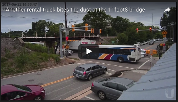
HGVs, lorries, trucks, whatever you call them, need to get from A to B without breaking either the road or themselves. Which means the map needs to know about height and width restrictions. 11foot8.com is a good example of what happens when truck drivers don’t have this information (and also can’t read):

11foot8.com

OSM coverage is good in parts but patchy. Fortunately, the existence of open street-level imagery means it’s really easy to map this sort of thing from the comfort of your own armchair. Here’s a brief how-to.

Step 1: Identify low bridges

The majority of important restrictions are height restrictions, and the great majority of height restrictions are railway bridges. (There are a few canal aqueducts too, though canal-related restrictions are generally weight restrictions on overbridges.)

See full entry

Dear HOT and OSM community,

I joined the HOT Board of Directors a couple of weeks ago and am now holding the position of the Board Secretary. As I am now also representing HOT and the HOT community, I put together this diary entry to explain my further professional relations and responsibilities.

Disaster Mapping and Management Department @ HeiGIT (GIScience Research Group Heidelberg University)

I am a Master student at the Geographical Institute of Heidelberg University and research assistant at the Disaster Mapping and Management department of the Heidelberg Institute for Geoinformation Technology. The objective of our department is to support humanitarian and disaster management organizations and volunteer communities through current technology, innovative methodologies and research, as well as through awareness building in our international research community. Therefore, the formal collaboration of the GIScience Research Group and Humanitarian OpenStreetMap Team includes collaborative work on tools and services, workflows, research, in teaching, and proposals, to support the objectives of the international Humanitarian OpenStreetMap Team community.

I am hereby not involved in any financial matters, my role is to rather build a bridge between the OSM/ HOT community, our department, and the GIScience research community in general. Apart from my work in the department, I also supported the NSF Eager Project on Crowdsourced Damage Assessment that was launched by HOT, Stanford Urban Resilience Initiative, GFDRR, and University of Boulder which I joined in a consultancy position for GIScience (Heidelberg University).

Missing Maps partnership with disastermappers heidelberg/ GIScience Research Group

See full entry

Posted by Zverik on 5 July 2017 in English.

Walking papers from the Tula Mapping Party

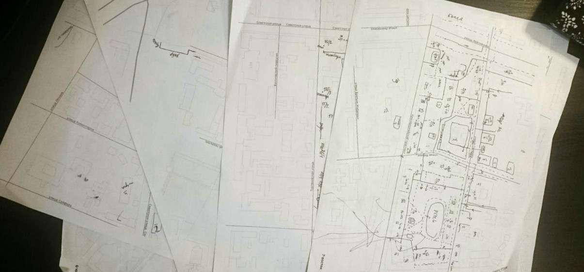
I have talked publicly about improvements to walking papers since at least SotM 2013. Made a blog post here in 2014 with some thoughts. But all I’ve seen were new ways to print tiles or atlases. While I admire the Field Papers and MapOSMatic fork improvements over the past years, a good walking paper is more than that.

For a long time I have been using a 28-step process to prepare walking papers for my mapping parties. It involved using Maperitive, Inkscape and some proprietary software. This year I finally got fed up with reanimating that old renderer, which doesn’t work perfectly on Linux, and tried something else. I had always been recommending QGIS for printing maps, and I decided to try it myself. Turned out, making walking papers with it is really simple and straightforward, albeit not without issues.

See full entry

Posted by Romainbou on 4 July 2017 in English. Last updated on 13 July 2017.

Hi all, I just adapted an OSM <–> Google Maps bookmarklet made by The_Knife, into OSM <–> Mapillary.

I find the Mapillary integration into iD quite usefull of course, but having everything drawn on the same window makes the whole thing very messy and hard to read. I always ended by opening a new tab for Mapillary navigation, and staying with a clear OSM window to work on.

The bookmarklet just open a new tab at the exact same place and zoom, in the other service, in both ways osm->mapillary and mapillary-osm.

So you just have to create a new bookmark in your favorite browser, and copy-paste the text below as the url field :

javascript:(function(){params=location.href.match(/openstreetmap.org.+#map=(\d{1,2})\/(-?\d{1,3}.\d+)\/(-?\d{1,3}.\d+)/); if(params!=null){ window.open(“https://www.mapillary.com/app/?lat=”+params[2]+”&lng=”+params[3]+”&z=”+params[1]);}else{params=location.href.match(/www.mapillary.com\/app\/.+lat=(-?\d{1,2}.\d+)&lng=(-?\d{1,2}.\d+)&z=(\d{1,2}.?\d)/); if(params!=null){ z=params[3];window.open(“osm.org/#map=”+Math.round(z)+”/”+params[1]+”/”+params[2]);}else{ alert(“OpenStreetMap - Mapillary impossible”);}}})()*

Here is the wiki page of the bookmarklet : Bookmarklet OSM-Mapillary

PS : the OSM <–> Google Maps bookmarklet can be found here and is extremelly useful. The_Knife also made a one way “->OSM” version of his bookmarklet, that is compatible with more url types : 0/0.000/0.000 or zoom=0&lat=0.000&lon=0.000 (can be in an other order and not in a straight string !)
And there is also a huge bookmarklet, MapJumper, that seems to allow switching between OSM and 35 other services, but I didn’t see mapillary in the list!

Romain

edit : Philipc enhanced the code today and I updated the text of the code written on this article accordingly.

While I will be starting using changesets in Tagalog, sometimes along with English, I started providing a translation of a changeset comment to another regional language, for example, Cebuano, when doing an edit in a specific area in the Philippines where it is the dominant language. While translations to Cebuano can be easily provided through Google Translate, this is something that is problematic with other regional languages, like Ilocano, Bicolano, Hiligaynon, Waray, Chavacano, etc., as a possible translator may not be reliable enough to provide a grammatically correct translation that a local can understand. Are there any possible reliable online translators for other Philippine languages, like for those I pointed above?

Posted by TagaSanPedroAko on 4 July 2017 in English. Last updated on 22 November 2017.

It was since January 2016 when I requested to map the less mapped barangays in southwest San Pedro, Laguna, which includes Magsaysay, United Bayanihan, Riverside, Laram, and Langgam. But, now, this effort now came to fruition.

From July 2017, after doing ground mapping after visiting Langgam, the less mapped areas of San Pedro, Laguna, finally has grown. Several POIs have been added, plus street names. The main priority is the important POIs, like schools, barangay halls, and churches. I have uploaded a GPX track as a guide when someone wants to realign the roads there, that are traced from aerial imagery, that may be offset.

Here are some POIs added on the survey:

  • Divine Gift School
  • Vian Rechel Academy
  • IETI
  • The Church of Jesus Christ of Latter-day Saints
  • 7-Eleven (Magsaysay branch)
  • San Pedro Relocation Area Cooperative
  • United Bayanihan Community Church
  • Alfamart (United Bayanihan branch)
  • Ministop (United Bayanihan branch)
  • Polytechnic University of the Philippines - San Pedro Campus
  • Laguna Relocation Community School
  • Upper Villages Christian Academy
  • Laram Barangay Hall
  • Most Holy Name of Jesus Parish
  • United Montessorean School of San Pedro (Langgam campus)
  • Jesus the Faithful Savior Christian School

Yet, several POIs and street names found on the survey are still not mapped, but can be mapped on following changesets. An update on the OSM Wiki page for San Pedro, Laguna provides all mapping updates (with dates for tracking latest updates). And for other POIs not found on the survey, I leave it to the other users (especially locals) to map, or note for others to resolve. The POIs added may start increased efforts to map the least mapped barangays of San Pedro.

Location: Langgam, San Pedro, Laguna, Calabarzon, 4023, Philippines
Posted by cugrassroots on 4 July 2017 in English.

Hello! It seems others have used the user diaries as a means of introduction before, so I thought I would do the same, especially since getting involved with OSM for me is in support of a broader research project.

I’m a doctoral candidate in Communications and Media with the Institute of Communications Research at the University of Illinois at Urbana-Champaign, and I’m interested in the evolution of location-aware projects in alternative media, particularly with the emergence of grassroots forms of mapping in mind. My dissertation thus relates to the political, cognitive, cultural, and social implications of digital mapping and increasingly available location-aware media technologies, and looks at alternative projects to learn more about the current state of digital mapping.

So, as I go about my dissertation research, I’ll be reviewing the community’s work, contributing through edits, and participating in mapping events. In writing up findings from this research, personal identifiers will not be published or presented - no such information (including usernames) will be included that would reveal any user’s identity in any results of the research.

Please don’t hesitate to message me if you wish to learn more. Thanks for reading, and I’m looking forward to contributing and learning more about the community’s work!

Posted by tyr_asd on 2 July 2017 in English.

The latest installation of my yearly osm node density visualization is now online: https://tyrasd.github.io/osm-node-density shows the freshest data from mid 2017 (while the results from previous years starting with 2014 are also available on the site’s layer selection menu).

Can you guess where the following example screenshot was taken?

Click here to find out.

Due to preparing for disaster situation, NCDR maintain a list of evaluated center in Taiwan. Some of these places are school. We could use this list and filter school, check if these schools are on OpenStreetMap. If there are missing schools on OpenStreetMap, we could draw the schools. Schools on NCDR data has much more items than GNS data.

/*
This has been generated by the overpass-turbo wizard.
The original search was:
“emergency=access_point and name~"國小|國中|高中"”
*/
[out:xml]/*fixed by auto repair*/[timeout:225];
// gather results
(
  // query part for: “emergency=assembly_point and name~/國小|國中/”
  node["emergency"="assembly_point"]["name"~"國小|國中|高中"]({{bbox}});
  way["emergency"="assembly_point"]["name"~"國小|國中|高中"]({{bbox}});
  relation["emergency"="assembly_point"]["name"~"國小|國中|高中"]({{bbox}});
  node["amenity"="school"]({{bbox}});
  way["amenity"="school"]({{bbox}});
  relation["amenity"="school"]({{bbox}});
);
// print results
out meta;/*fixed by auto repair*/
>;
out meta qt;/*fixed by auto repair*/

OverPass Turbo Link

Location: Hongcuo, Linkou District, New Taipei, 24451, Taiwan
Posted by apm-wa on 2 July 2017 in English.

Ann and I explored the neighborhood around Duşanbe köçesi this afternoon as the new satellite imagery and map as drawn did not correlate. Collected some good ground-level imagery with Mapillary and good GPS traces with the Garmin navigator, and updated the map in that neighborhood. Also located (and added) the Border Service Institute and the mineral water sanitorium in Berzengi, location of both of which had been minor mysteries!

We keep adding bus stops, thanks to Mapillary, and at some point I hope somebody will help with including data on bus routes.

We finished with a visit to the Watutin (Vatutin) Cemetery, where we geolocated two significant monuments, to the composer Nury Halmamedow and the physician cum Sanskrit scholar Boris Smirnov, who translated the Mahabharata into Russian.

I am increasingly more impressed with Mapillary than with OpenStreetCam. It works with with ID, its base map is kept updated (OpenStreetCam’s is woefully out of date), and it does not try to force traces to align with existing highways in OSM, leading to greater accuracy.

Recent discussion on breaking up multipolygons in to smaller units. Note that the original polygon contains many members. The objective was to show the original land use of an area adjacent to, and draining into, the Alberni Inlet as a natural wood (forest), then break the area in to smaller units based on the nature of the tenure. The tenure in most cases sets the major purpose of the land use.

The initial comment could be based on my saving a session with a number of errors which I intend to correct through the work to be done on setting smaller units, as described below.

Comment from (OSM contributor) about 6 hours ago

Do you know what you are doing?
Comment from Robert Copithorne about 3 hours ago

Hello. Yes, I believe I am doing what is required, but I am aware that I created a big potential problem for myself when I created a very large complex multipolygon related to land use in Alberni land areas. Things became more difficult when I started to break the large multipolygon in to smaller pieces; specifically portions related to Strathcona Park, and Western Forest Products operations at Great Central Lake. Currently I face a large task of separating the elements of the three multipolygons, but I am working on that, and I believe will be able to straighten it out.. Any suggestions you may have at this point that would help to reduce the work involved would be appreciated.

Comments from other users relevant to the issue of splitting multipolygons in to smaller units would be appreciated.

Additional Info: Having worked in Forestry in areas around Port Alberni, including updating Forest Inventory maps, I am intensely interested in developing a map of land uses, features and access roads in the Alberni Inlet drainage area, and adjacent areas, for the benefit of all users.

Location: 49.223, -124.800

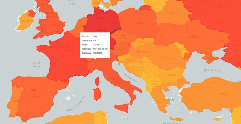
How many contributors are active in each Country?

I recently put together this visualization of users editing per Country with along with some other basic statistics. This analysis is done with tile-reduce and osm-qa-tiles. I’m sharing my code and the procedure here.

Users by Country

This interactive map depitcs the number of contributors editing in each Country. The Country geometries are in a fill-extrusion layer, allowing for 3D interaction. Both the heights of the Countries and the color scale in relation to the number of editors. Additional Country-level statistics such as number of buildings and kilometers of roads are also computed.

Procedure

These numbers are all calculated with OSM-QA-Tiles and tile-reduce. I started with the current planet tiles and used this Countries geojson file for the Country geometries to act as boundaries.

Starting tile reduce:

See full entry

Location: Boulder, Boulder County, Colorado, United States