Diary Entries in English

Recent diary entries

How hard can it be to map a cycle route in Christchurch? I hit the “Edit” button on Open Street Map to find out.

The Christchurch City Council (CCC) is developing a programme of 13 major cycle routes to connect suburbs to the central city. “Papanui Parallel / Puari ki Papanui: This cycleway will connect Northlands and the Northern Line Cycleway to the Central City”. The CCC website has a page on the Papanui Parallel with detailed plans of the approved scheme design for every section of the route. ( https://www.ccc.govt.nz/transport/cycling/major-cycle-routes/cycle-routes/papanui-parallel/ )

Only a small stub of the Papanui Parallel was visible on the osm cycling basemap on the north side of the intersection of Colombo Street and Bealey Avenue. Construction of the Papanui Parallel is nearly finished so it seemed appropriate to update.

My first step was to address the route as a relation. I used the Little River Rail Trail as a guide, as the Little River Link Trail is an official project referenced by both the New Zealand Transport Agency (NZTA) and CCC. The Little River Rail Trail is tagged as “rcn”; the Coastal Pathway, by way of contrast, is tagged as “lcn” even though the link to CCC cycle projects is unclear; so I tagged the Papanui Parallel as “rcn” - a regional cycle network. Someone seems to have set up a CCC custom tag, so I also tagged the Papanui Parallel as “ccc=cyclingroute”.

Starting at the southern end of the Papanui Parallel, Sheet 17 of the plans seemed fairly straight forward. “Bike Lanes” on the left and right side were clearly “tracks” as being “separated from the road by curbs, parking lots, grass verges, trees or another physical barrier, but is running parallel and next to the road”. ( osm.wiki/Key:cycleway )

See full entry

Location: Saint Albans, Fendalton-Waimari-Harewood Community, Christchurch City, Canterbury, 8052, New Zealand

thumb-2048 1

‍‍ಕನ್ನಡ ನಾಡು ಕಂಡ ಮೇರು ನಟ, ನಟಸಾರ್ವಭೌಮ ಡಾ. ರಾಜ್ ಕುಮಾರ್ https://en.wikipedia.org/wiki/Rajkumar_(actor)‍ ಅವರ ಸ್ಮಾರಕವನ್ನು ಈಗ ಎಲ್ಲರೂ ‍‍ಮ್ಯಾಪಿಲರಿಯ ಮೂಲಕ ಕುಂತಲ್ಲೆ ವಿಕ್ಷಿಸಬಹುದು. ‍ಕನ್ನಡ ನಾಡು ನುಡಿ ಮತ್ತು ಚಿತ್ರರಂಗಕ್ಕೆ ಅವರ ಕೊಡುಗೆ ಅಪಾರ. ಚಿತ್ರರಂಗದಲ್ಲಿನ ಜೀವಮಾನದ ಸಾಧನೆಗಾಗಿ ಭಾರತ ಸರ್ಕಾರವು ಚಿತ್ರರಂಗದ ಅತಿ ದೊಡ್ಡ ದಾದಾಸಾಹೇಬ್ ಫಾಲ್ಕೆ ಪ್ರಶಸ್ತಿ ‍ಯನ್ನು ನೀಡಿತು. ಇತ್ತೀಚೆಗೆ ಗೂಗಲ್ ಇಂಡಿಯಾ ಅವರನ್ನು ‍ಗೂಗಲ್ ಡೂಡಲ್‍ ‍ಮೂಲಕ ಗೌರವಿಸಿತು. ‍

See full entry

Posted by Shakemasta on 18 June 2017 in English.

I am only for a short visit here in Baños and I have two questions:

When I want to find the way to termas el salado from the city center it directs me over the street luiz martinez and then over the river: THERE IS NO STREET at all, unpossible to cross. How can I change this?

Second: There are soo many places not on the map, who could do a propper update?

Thanx for every answer!!

Location: Illuchi, Baños, Baños de Agua Santa, Baños, Tungurahua, 010151, Ecuador

The month of June,2017,became a busy month for me with the planning and prepartion to launch a new chapter of youthmappers in Nigeria,the UniqueMappersTeam(UMT)Port harcourt,Nigeria domicilled in University of Port harcourt,where,I work as a Principal GIS-Cartographer in the department of Geography and Environmental Management. I started with raising a team of students I intend mentoring in my field of geoinformatics,assisting to secure internship for their 6 months industrial training and spending the first and second week of june to give them leadership training to work as a team,getting them sign-up for OSM and teaching them to map with OSM and then using peer-learning to get them prepare their own training manuals. On 12th June,2017,I created a whatsapp chat group where I made some of them administrator and we were able to have 40 members who join the chat group by the same week ending 17th June.These chat group members were made up of undergraduate students,post graduate students, and some departmental staff to observe the on going development.I linked up a survey form to campaign for volunteers and amazing was the response. We proceeded to upload our training manuals on how to use OSM to map,linked them to www.learnosm.org and guide them through the essence of the chat group.We uploaded our leaders training session pictures to motivate them and then prepared them for our upcoming mapathon and inaugural the following week.

Location: Alakahia, Obio/Akpor, Rivers State, 500004, Nigeria

The first coding period of the Google Summer of Code has begun! So far, I’ve worked on a draft for the REST API, which you can see here, so that we can iterate on it, and 3D visualizers for OSM can start planning their implementation. I’ve also designed all the web pages that will be used for the 3D Model Repository, using Bootstrap, as can be seen at the end of this entry.

I have also changed how the nightlies were generated from my original proposal, which defined them as a collection of the most important models, to having all the models in the nightlies, so that you can get all files from the repository by downloading all of them. They will be in separate size-limited chunks now, to make it easier to download versus a big file.

Now that my semester is over, the pace should pick up quite a bit, with the full design of the database schema, integration of the web designs into Django and OAuth authentication planned until the end of the month.

Finally, we now have a (possibly temporary) repository on GitLab!

See full entry

A friend of mine plans a big thing: Driving the whole Panamericana from Alaska all the way to Tierra del Fuego. While talking to him and his family it turned out that maps are a big issue and while casually checking out the route I realized there’s much improvement needed.

I don’t have a real plan yet, but while checking against several USGS and NASA WMS-services I also realized that the Panamericana crosses several zones prone to natural hazards, e.g.: * Landslides * Volcanic hazards * Earthquakes

Bringing all the data together in QGIS I was shocked that so many people are living there, villages are completely uncharted, no interconnecting roads available, it’s truly terrifying.

Just look at these examples; I checked an area in Guatemala north of the volcano Tajumulco; the status of this volcano is unclear, but nevertheless, there’s a clear landslide hazard: Bing Aerial Bing Aerial (click for fullscreen)

See full entry

Location: San Marcos, Guatemala
Posted by Chetan_Gowda on 14 June 2017 in English. Last updated on 7 April 2021.

Microsoft recently released 9.8 million building footprint data of 102 cities covering 44 US states to the OpenStreetMap community. This is a huge boost to improve the building data in many parts of the United States. Right now, we have ~ 19 million buildings already added by the community through imagery tracing and imports.

The most exciting part of this data is that all the footprints have height information. That means we can generate simple 3D buildings. I downloaded all the data and created a Mapbox style with 3D extrusion:

In general, the data is of good quality and will improve the building coverage in the US by 150%. But the quality may vary from city to city. Local mappers should evaluate each city before deciding to import.

Feel free to play with data, post your findings or screenshots of the data evaluation for the city you are interested in and let the community know how valuable this data is going to be for OpenStreetMap.

Code and step is available in Github repo: https://github.com/osmlab/ms-building-import/

* California not included in the tileset since OSM has fairly good coverage

Posted by marthaleena on 14 June 2017 in English.

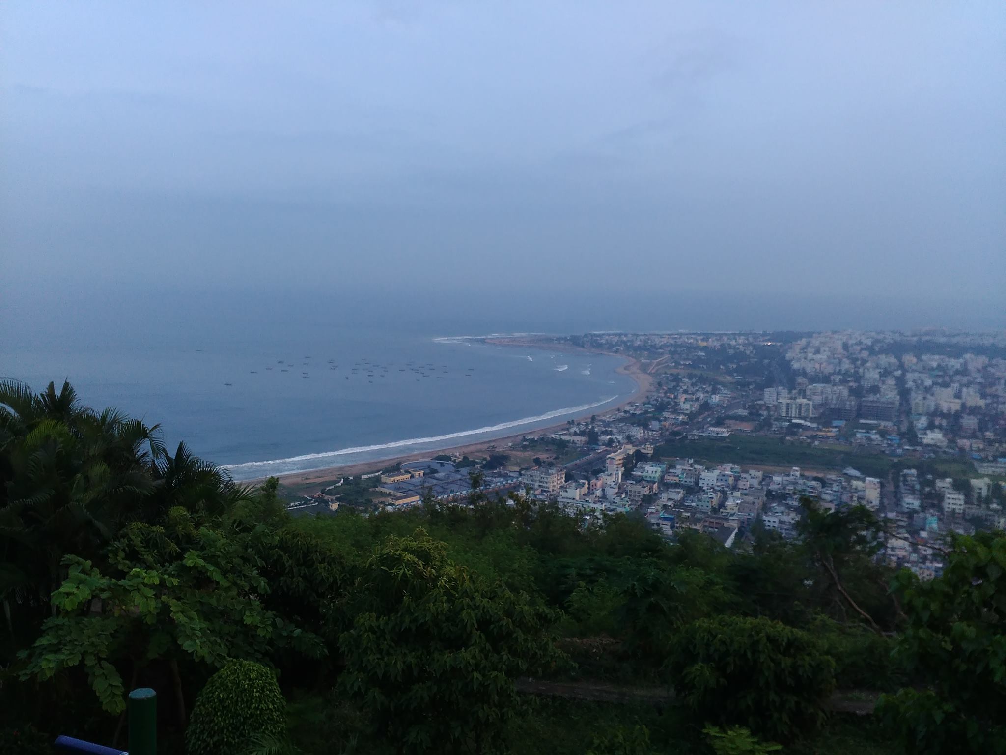
vizag_city_aerial_view Photo taken from wikipedia

విశాఖపట్నం సుందరమైన దృశ్యాలకు ప్రసిద్ధిగాంచింది. అందుకు దానిని “గమ్యపు నగరం” అని కూడా అంటారు. సాగర తీరాన ఉన్న పార్కులు,రిసార్ట్ లు కనులవిందు చేస్తాయి. అనేకమంది తీరాన్ని వీక్షించడానికి వస్తారు. నాకు సాగర తీరం వద్ద బంధుమిత్రులతో అనేక మధుర జ్ఞాపకాలు ఉన్నాయి. నేను నివసించే ప్రదేశం మహారాణిపేట, అది జగదాంబ సెంటర్ కి చాలా దగ్గరగా ఉంటుంది . ఈ సెంటర్ బట్టల దుకాణాలతో, సినిమా హాళ్ళతో , రెస్టారెంట్లతో నిండి ఉంటుంది. కావున ఎప్పుడు జనాలతో రద్దీగా మరియు సందడిగా ఉంటుంది.

See full entry

Location: Waltair Uplands, Siripuram Junction, Visakhapatnam, Visakhapatnam (Urban), Visakhapatnam, Andhra Pradesh, 530001, India
Posted by jbelien on 13 June 2017 in English. Last updated on 3 June 2018.

Cet article est également disponible en français : http://www.openstreetmap.org/user/jbelien/diary/41687

The story begins in February 2017 at FOSDEM (https://fosdem.org/) in Brussels ; a cheerful Albanian delegation arrives on the Brussels ground. Among these Albanians, Anisa Kuci and Redon Skikuli, members of OSM Albania; since they are on Belgian soil, they decide to contact OSM Belgium and yaaay, some of us also attend the FOSDEM. First contact around a Belgian beer, our new Albanian friends announce that they are organizing an open-source conference at their home in Tirana in May: OSCAL (Open Source Conference Albania) and that we are welcome. Even if these Albanians are rather nice, Tirana is not really one of the dream destinations. I therefore answer politely (and prudently) that I will think about it. FOSDEM ends, weeks pass and I kept in touch with Anisa and Redon … I discover that they manage a “hackerspace” in Tirana and that they organize full of interesting events related to the open source (in addition to OSCAL). The idea of ​​visiting Tirana is gradually becoming a necessity. And why not go discover this city and these people I know absolutely nothing about and take advantage of it to attend an open-source conference.

Hotel booked, airline tickets purchased, so I decide to spend 5 days in Tirana for the fourth edition of OSCAL. Arrived on Friday in the early afternoon, I take advantage of my afternoon to visit OpenLabs (https://openlabs.cc/en/), their “hackerspace”. Small friendly place at the end of an alley, I met other members of the hackerspace as well as 2 American speakers that also came a little bit earlier.

See full entry

Location: Qyteti Studenti, Njësia Bashkiake Nr. 2, Tirana, Tirana Municipality, Tirana County, Central Albania, 1000, Albania

1. The most simple way is to count just the ways with the highway tag that are at version 1

But …

This fails when we approach the fact that when you split a way, the longer segment will remain with the WAY id, and the smaller way will get a new ID, meaning that it will be version 1. Alt text

2. We can use the nodes of the ways

Using the nodes as a identifier, because even if the way is new, all of the nodes are still from the old way, meaning that the timestamp will be different, the user that created the node will be a different user then the user of the way.

3. But how can we find out this in OverPass ?

See full entry

Posted by GOwin on 13 June 2017 in English. Last updated on 14 June 2017.

Thank you to all the participants who spent their Saturday afternoon with us, mapping the city of San Juan, over Independence day weekend. We’re also thankful to San Juan City (and their DRRMO) for making the venue and facilities available.

And a shout out to Mapillary, for the refreshments.

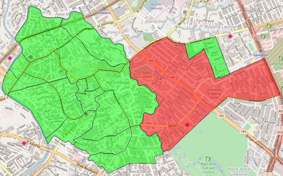
This is the second city mapa-thon, and a follow-up activity to enhance the Free/Open data collection of the city of San Juan, and to complete the leftover tasks from the last mapa-thon, chiefly working in the second district of the city: >image > Shown here are the 21 barangays of the city, using the MapCraft tasking manager >Data © OpenStreetMap contributors (ODbL); Image © MapCraft

See full entry

Location: Corazon de Jesus, 1st District, San Juan, Eastern Manila District, Metro Manila, Philippines
Posted by kucai on 12 June 2017 in English.

I have just explored the newly available Digitalglobe imagery around Malaysia, and was blown away with its coverage after all these years waiting for Bing. It was almost orgasmic! Not to mention the few that I worked with aligned almost exactly with my gps tracks, right in the middle of the road. Very happy, despite finding some sort of distortion (wavy terrace houses) with the imagery. Perhaps that could very well be caused by the unserviced surveyor’s theodolite during the housing area survey & marking stage.

Then it dawned on me..all those areas to be traced. That’s a seriously a huge amount of work to be handled by a handful of OSMers around here. Going to need a couple hours dedicated to tracing everyday whenever possible, starting with the important features first : streets in cities and towns, then following up with residential areas and the like.

Nevertheless, thank you Digitalglobe!

p/s anybody had trouble with JOSM (ver12039 here) acting up? At one point, text input doesn’t work anymore, but mouse actions work (pressing buttons & stuff). Just wondering although my Opensuse Leap 42.2 laptop isn’t that top notch either - btrfs, kde plasma & memory are possible issues. Maybe it is my laptop… anyways…. peace out.

Posted by ff5722 on 11 June 2017 in English. Last updated on 30 June 2017.

It’s not exactly a secret that the official Chinese government statistics are often made up or obfuscated. The official stats for road network length say 4,696,300 km of roads. According to the CIA world factbook, China has 4,046,300 km of paved roads. In 2016, on OSM 1,635,931 km of roads was mapped in China. Update: in June 2017 we’re already at 2,022,047 km!

Now compare the OSM data of a typical countryside area to the satellite imagery.

Pretty much all unclassified roads are still missing from OSM, and this is the case for most of rural China. Even for cities, there are only a handful of cities that have their residential roads mapped well. So it leaves me wondering, is the 4 million km of roads in total a realistic statistic?

See full entry

I’ve updated the switch2osm “Manually building a tile server (16.04.2 LTS)” page to use the latest version of the osm-carto style, now that the issues underlying this problem have been fixed.

This means that it should be possible to follow these instructions to set up a tileserver from scratch that creates tiles in the same style as OpenStreetMap’s “standard” style in just a few hours (for small areas the longest period of the setup is waiting for the shapefiles used by the style to download).

What would be really useful would be if people could test that these notes do actually work for them - is there anything that should be made clearer, especially to someone who might not be familiar with Linux at all?

While I was looking through the area I’m busy mapping, I noticed all kinds of weird errors in the French land registry. Now, we all know French bureaucracy is hell, but the folks who do the land registry are sometimes weird. Here are some examples:

This looks.. different…

See full entry

Location: Fresse-sur-Moselle, Épinal, Vosges, Grand Est, Metropolitan France, 88160, France
Posted by Jothirnadh on 8 June 2017 in English. Last updated on 14 September 2018.

The most common error we end up doing while splitting well-mapped roads in a highly mapped area is by breaking a route relation. This usually involves breaking the continuity of a bus or highway route due to missing members. The community has reported broke route relations while the data team was trying to improve navigation features (Turn lanes & turn restrictions) in US cities. On thorough research found some points to share with you all and hope this helps in solving route relations breakages in future.

The first thing to note, there is nothing wrong with any of the split way or knife-tool that we use to split the road. In general, route relations are very long and spreads across the city. When two or more persons work at the same time, on editing roads part of the same route relation, JOSM will throw relation edit conflict. This conflict is very specific on which version of the edit to keep and which one to remove. In general, people tend to resolve the conflict by pushing their edits and skipping the other’s edits. This causes the route relation breakage. Let me explain clearly with examples.

Example:

For this use case, I took a bus route (Relation: 333P) in Bangalore, India and tried to download the data into JOSM at two corners of the route into two different layers (layer-1 & layer-2). Now the route relation 333P has 89 members at version-61.

See full entry

Location: 12.981, 77.640
Posted by GOwin on 8 June 2017 in English. Last updated on 22 June 2017.

I just finished reading Side-by-side images expose a glitch in Google’s maps which highlights some shortcomings of Google Maps (GM), which the writer call as “glitches”.

I find that amusing because I often hear the same assertions against OSM. Immediately, I wondered how the OSM community is faring in those same areas:

Morro dos Prazeres

image © 2017 BBBike.org & Geofabrik GmbH - map data (©) OpenStreetMap.org contributors

Makoko, Lagos

See full entry

Location: Santa Lucia, 2nd District, San Juan, Eastern Manila District, Metro Manila, 1500, Philippines