Diary Entries in English

Recent diary entries

Posted by pnorman on 17 April 2017 in English.

Dear all,

Today, v3.20 of the openstreetmap-carto stylesheet (the default stylesheet on openstreetmap.org) has been released.

Changes include

  • Render aeroway terminal buildings like other buildings
  • Removed rendering of landuse=farm
  • Added rendering for arts centre, fitness centre, plant nursery, mixed lift aerialways
  • Rendering for fens changed
  • Typography for point road-related features, addresses, and water features changed
  • Removed rendering of waterway=canal as an area
  • Take text properties of roads under construction from the type of road they will be

Thanks to all the contributors for this release including Richard Fairhurst and jnachtigall, new contributors.

For a full list of commits, see https://github.com/gravitystorm/openstreetmap-carto/compare/v3.2.0…v3.1.0

As always, we welcome any bug reports at https://github.com/gravitystorm/openstreetmap-carto/issues.

Posted by mikelmaron on 17 April 2017 in English. Last updated on 18 April 2017.

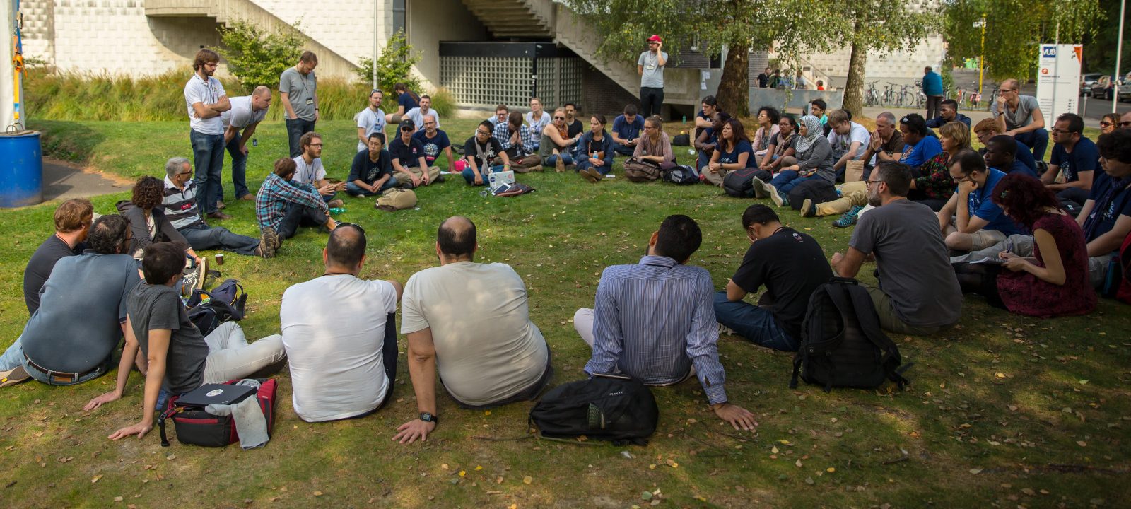
The sun shined on the Local Chapter Congress at State of the Map 2016. It was fantastic to hear from so many people from so many communities.

Yes, sorry, it is long overdue to share – shortly after SotM, I took leave after the birth of my son, and only finding space to pick this up with the upcoming Board Face to Face.

There were many solid ideas, and of course further discussion. Would love to find several avenues to explore these. I think one could be the Advisory Board, which will include representatives from official Local Chapters. For “incubating” local chapters, maybe we discuss ideas on the local chapters mailing list. For communication ideas, we should figure out the right place…

Dorothea took thorough notes from the session. Posting the summary below.

Organising local communities

How OSMF Could Help?

See full entry

Posted by alexkemp on 16 April 2017 in English. Last updated on 4 July 2022.

It has been a mighty long time since I documented some Street Art (the last was some Lions in Gedling, Gedling’s obsession with stick-men, then in Wollaton Avenue but the main last entry was back in November).

This first is Gedling’s variation on Nottingham’s Plaster Boys ‘n’ Girls:–

Gedling’s Plaster Boys ‘n’ Girls

(that variation appears to be positioning them on the street such that motorists get a sporting chance to mow the actual schoolchildren down, and only then are presented with a line of Plaster Children to warn them not to do so) (the school entrance is behind the photographer & in front of these school_sentrys) (also, notice how Mapillary has carefully blurred every face)

See also:– > man_made=school_sentry

Next is a house-elf (at his feet are rescued cobbles from a Nottingham street):–

See full entry

Location: Gedling, Carlton, Gedling, Nottinghamshire, East Midlands, England, NG4 4BH, United Kingdom
Posted by alexkemp on 15 April 2017 in English. Last updated on 4 July 2022.

I’ve just uploaded some changes to this proposed road on OSM (I’ve also made it an associatedStreet Relation so that all the various connecting roads + roundabout(s) can be viewed together):–

Gedling Access Road (GAR)

Note:– the GAR cannot be viewed in ordinary circumstances on the OSM map until it is built. It has, however, already been mapped. Therefore, the link above will show the whole of the GAR as planned in the context of the current map.

See also:–

The map provided from the council shows it passing through the middle of some Retention Lagoons (I certainly hope not - our route misses them).

No GIS is available (that I know of) so I’ve used a combo of what appears to be a detailed, accurate (but tiny) map & a much larger, and out-of-date, inaccurate map to hand-draw as accurate a route as I can manage.

The planned Gedling Access Road (GAR) is a 3.8km road which will run from Mapperley Plains to the A612 at the Burton Road/Nottingham Road and Trent Valley Way junction.

Planning permission for the road was approved in December 2014. Construction works for the road is due to start in (Spring) 2017 with completion set for (Spring) 2019.

Added 10 May 2017:
I’ve recently photographed + mapped the fields north-west of the abandoned Chase Farm (killed by the GAR). The fence on this photo (first one below) is the line that the GAR will take, and the land dead ahead for many miles is what it will travel over (initial work for the Arnold Lane interchange can be seen beyond the fields).

See full entry

Location: Gedling, Carlton, Gedling, Nottinghamshire, East Midlands, England, NG4 4BH, United Kingdom

The extension of Magtymguly şaýoly west to the traffic circle on Köşi köçesi has been opened so I collected GPS traces today, tweaked the path of the street under construction, and removed the construction=yes tag. Ann held the iPhone to collect OpenStreetCam data, which allowed us to add bus stops on the new section of street and verify location of traffic lights (stoplights) and intersections. osm.org/way/479294344

Location: Koshi, Bagtyyarlyk District, Ashgabat, Turkmenistan
Posted by alexkemp on 14 April 2017 in English. Last updated on 4 July 2022.

Yet another first:– the first working farm that I’ve mapped (other, non-working, farms in Gedling have been Manor Farm Arnold Lane, Glebe Farm Lambley Lane, Phoenix Farm Arnold Lane 1, Phoenix Farm Arnold Lane 2 & Scot Grave Farm Arnold Road). You can find Gedling Wood Farm farmyard & fields here:

The farmer was enormously helpful; she made a photocopy of the field layout for me and named every field. In return I’ve spent an hour moving the existing landuse=farmland out of the way & have entered the first 6 fields on to the map. I like the way that they are rendered on the standard map; much more subtle than drawing the hedges in.

I’ve got one difficult decision to make. Ordnance Survey have two “Gedling Wood” on the map, which OSM have duplicated + added a third:– [1] is to the north & larger; [2] is invented; [3] is close to the farmhouse & smaller. The farmer named the field containing the smaller wood as “Little Wood”. I’ve got a suspicion that the farmer will know the names of the fields & woods better than the OS do, so am tempted to rename it (and remove the invented wood). Still, that is for tomorrow.

This is the farmhouse; it is ever so much older than you think (1600s - she named some feature about the windows as being an example of that period, but I could not retain it; naturally, the farmhouse also has a well):–

See full entry

Location: Gedling, Carlton, Gedling, Nottinghamshire, East Midlands, England, NG4 4BH, United Kingdom
Posted by alexkemp on 13 April 2017 in English. Last updated on 4 July 2022.

It’s not often that I get the chance to enter something utterly new onto the Map, so please forgive me if I crow a little about this one. However, it will not be very loudly since, although I’m most certainly not an arboriculturist, IMO this copse of trees should be levelled to the ground, burnt to ashes & started again from scratch.

PS
IANAA makes a pleasant change to IANAL, does it not?

Harvey’s Plantation
A circular copse of trees; close to though unconnected with local buildings, it stands amidst farmland and, whilst a couple of hedges and a small stand of trees connect, it is alone. On the ground, local trackways appear to get close, though none connect directly & few are officially mapped. Gedling Council have stated in connection with a Preservation Order on the copse (below) that “…the woodland had been a local landmark for over 100 years and makes an important contribution to the landscape.”

This is a distant view from the North-East (the copse starts at the break in the tree-line at the left):–

See full entry

Location: 52,983, -1,078
Posted by alexkemp on 12 April 2017 in English. Last updated on 4 July 2022.

My first discovery of a drovers’ road was last February (see also a terrific description by one of the History Girls). I think that I’ve just found another one in Gedling, plus an odd trackway nearby, plus a vast long Public Footpath, and a circular Plantation, all of which are most odd. However, one thing at a time, and for this diary entry it is to be the Public Footpath and a (possibly) unmarked Drovers Road.

The drovers’ road in Ware showed that, typically, Drovers Roads are marked as Public Byways on local signs. There is no such signpost for this one, which is why I keep using the words “if” & “possibly”. The field at the start of a very long Public Footpath [1+2+3+4+5] is most odd & when I saw it I went “THAT’S A DROVERS’ ROAD!!!”. See what you think:–

a drovers' road?

The original mapper was perplexed by what he saw & put in a fixme within the area (now removed):–

  • “not sure of the tagging here - basically it’s just full of thistles and not crops”

See full entry

Location: Rivendell, Stoke Bardolph, Netherfield, Gedling, Nottinghamshire, East Midlands, England, NG14 5HH, United Kingdom
Posted by muramototomoya on 12 April 2017 in English. Last updated on 29 June 2017.

Event

Other

Over the passed year, the Belgian community was involved in organizing 10 mapathons. It is an incredibly easy thing to do, once you have the documentation in order. And once you realize you should do as little as possible - just find people who have a location and a recruiting network.

Some time ago, Pascal Neis wrote an article about new mappers recruited through classic channels, Maps.me and humanitarian mapping. I asked and got a changeset dump of all the people who participated in our mapathons.

Here’s some stats about that.

Overal, 1925 unique mappers participated in our mapathons, of which 328 were new mappers.

First, did we manage to turn them into returning mappers? Well… As could have been predicted by Pascal’s depressing numbers: not really. The data used was from December 2016. You can clearly see that the percentage having more than one mapping day drops as we approach December. That simply means you need to wait a bit before you can do a decent analysis.

image

See full entry

Posted by joost schouppe on 12 April 2017 in English.

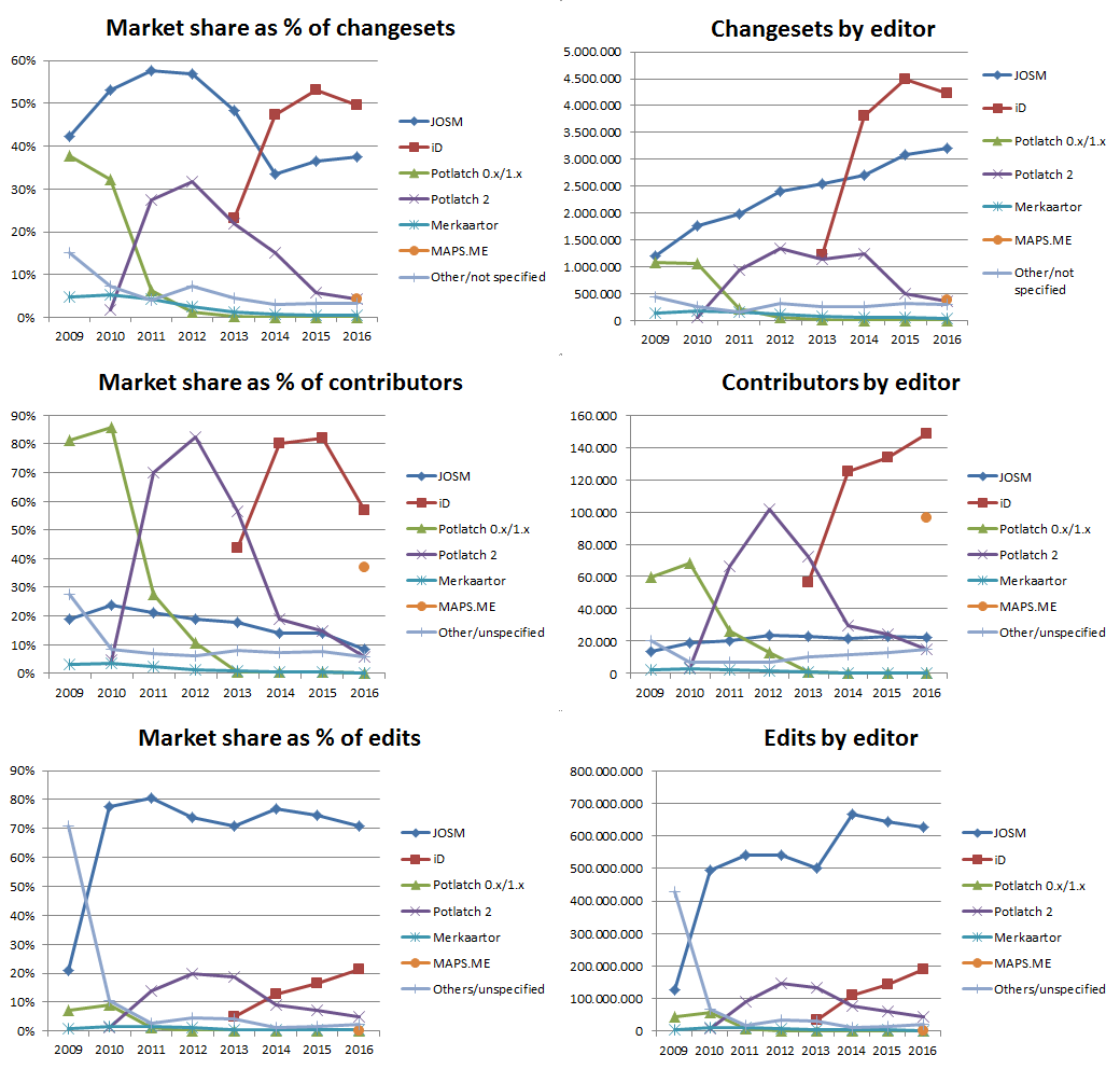
This wiki page has a nice collection of stats on editor popularity. The data is up to date, but the graphs aren’t. I’m not a big fan of the logarithmic scale either.

So here’s one graph to tell the main story.

I focused on “the big editors” to keep the graph simple. If you want more detail, just head over to the wiki page.

You can read the graph horizontally, showing first the distribution of changesets, then number of unique contributors, then total edits. On the left, market share. On the right absolute numbers.

Graph full size

See full entry

It’s important to see what exactly happened to features in a changeset. This means identifying the state of each feature, the history, including geometry and tags that changed. The OSM changeset page doesn’t give you a clear idea of what happened in a changeset - you see a list of features that changed, and the bounding box of the changeset.

image

The changeset XML from OpenStreetMap only has current version of the features that changed in the changeset.

Overpass offers augmented diffs between two timestamps that contains current and previous versions of each feature that changed in that period. We put together an infrastructure that queries Overpass minutely, prepares changeset representation as a JSON, and stashes them on S3. The augmented diffs are also cached on S3. This means that the load to Overpass instance can reduce drastically while many of us are looking at the same changeset.

See full entry

Location: Hoysala Nagara Central, Bengaluru Central City Corporation, Bengaluru, Bangalore North, Bengaluru Urban, Karnataka, 560038, India
Posted by mavl on 12 April 2017 in English. Last updated on 25 January 2018.

Tyumen Oblast is small region in Western Siberia. It has total area about 160 000 square kilometres and population about 1 340 000 (308 persons (or 0.02%) are OSM contributors).

Years and years ago first human settlement was marked on OpenStreetMap in Tyumen Oblast. It was Tyumen (was added by contributor LA2). This event happened in 2007.

Many local contributors improved OpenStreetMap after it.

New local contributors

Year is a year when an account was created.

Probably, these contributors live in Tyumen Oblast because they usually edit in this area. Of course, some contributors of other regions improve OpenStreetMap in this area also.

Since 2016 there are local maps.me contributors.

See full entry

Location: Дом Печати, Центральный административный округ, Tyumen, городской округ Тюмень, Tyumen Oblast, Ural Federal District, 625000, Russia

Another round of HOT board elections is about to close, and for the first time I’m participating as a voting member. As I write this I don’t yet know the results, we will review them at the member AGM tomorrow. An exciting moment! The community discussions around this also made me aware that these election cycles are always an opportunity for a new generation of HOT members to become our representatives. From personal experience I know that this can be a daunting transition, so I invite all candidates to lean on your community for support: we believe in you, and we can offer you advice and support, if desired. (Chances are you’re already very knowledgeable and experienced.)

Such a moment might feel particularly daunting if you’re not used to being in such a prominent position within a large public organisation. This is likely true for most humans! Possibly with some exceptions – as a white male I practically get status thrown at me, and I mainly just needed to learn how to accept it with grace. But people’s experiences differ. Maybe you were taught modesty as an important virtue, and to not be too assertive in your interactions. Through many conversations over the years I have learned that such small differences can affect our respective self-image, regardless of our actual competencies; and they may inform how we approach the prospect of becoming a board member.

I’m writing this post in anticipation that we may see some new faces on the board, if not this round then later. I’m writing to share the things I’ve been taught to take for granted; and I think you should take them for granted too. (This is not a universal set of recommendations. Many people won’t be able to relate to this, or only in parts. That’s fine. You will know if this speaks to you.)

First of all, I believe in your achievements, and I will call you an expert without thinking twice about it.

See full entry

A foto foi tirada 17 horas da tarde do dia 13/03/2017, por do Sol de um dia ensolarado. Foi em um local de Jacaraípe desconhecido, no qual a rua possui muitas árvores e sem asfalto além de ser tranquila e serena…. ![Lagoa de Jacaraípe, Serra, Espirito Santo, Brasil.] (http://i.imgur.com/wolLDKO.jpg)

Location: Lagoa de Jacaraípe, Serra, Espírito Santo, Southeast Region, Brazil
Posted by ff5722 on 10 April 2017 in English.

USGS has published tree cover data based on 2010 Landsat captures. I wonder if this data would be suitable for importing. Especially outside of Europe, forest cover is largely incomplete now, and 2010 is fairly recent for this kind of data.

https://landcover.usgs.gov/glc/TreeCoverDescriptionAndDownloads.php

In the licence requirement it says: University of Maryland, Department of Geographical Sciences and USGS; use is free to all if acknowledgement is made. So it is not obvious if using this data is allowed.

The data is provided asgreyscale geoTIFFs, i have uploaded one tile as a preview here:

https://api.mapbox.com/styles/v1/hindbaer/cj19m696v009v2ro4rwlq18k3.html?title=true&access_token=pk.eyJ1IjoiaGluZGJhZXIiLCJhIjoiY2lqOGt4bG1wMDAweXR0a25vcGx4ZmUzNCJ9.R55CveYJBChT-Olntza9Mg#7.21/23.611/121.796

See full entry

OSMCha has this great feature of watching edits around your neighborhood using the bounding box (bbox) filter. Today, I reviewed several edits using the combination of bbox and the new mapper flag.

screen shot 2017-04-10 at 16 07 54 </br>New mappers in the Philippines in the last couple of days

Note: Being a new mapper does not mean making bad edits per se, but by being new, we can commit errors because of unfamiliarity with the best practices of editing. Admit it old mappers, we made mistakes before. ;)

As I review each changeset, I often fix common errors based on my familiarity with the area. After fixing, I usually add a comment to the user’s changeset explaining my edits and encouraging them to continue contributing to the project.

See full entry