I fell down the rabit hole, learning about OSM, in order to port the map into a video game called Farm Simulator. They suggested I just rip it, and add what I want unsaved before I port, then realized I might as well just contribute to this neat open source database! I actually find it quite satisfying, and hope I’m helping. I’m not sure how long I’ll stick around, but I’m already at the max contribution…
Diary Entries in English
Recent diary entries
The weather’s not been great around here, so I’m keeping myself busy (and out of harms way) by updating OpenStreetMap – there are lots of missing buildings here and there, and a few missing pathways and trails.
I’ve been focusing on the Ely, Caeru, and St Fagans areas in Cardiff as I’ve a particular interest in their history (see my previous posts). My aim is to add more detail to the woodland areas, especially the locations of hidden historical sites and secluded trails.
There are lots of buildings throughout that also need re-aligning, with the last edit for many being sixteen years prior! I’ll continue to chip away until everything’s up to date – given the horrid weather, I shouldn’t run short on time!
I’ve been editing and modifying things on OpenStreetMap for about a year now, which is just insane to me!
I had never thought I’d make it to this point. At first, I was trying to modify a village and make it look a little better, but now, I can modify a lot of places.
If I showed my account to myself a year ago, he wouldn’t believe me.
Of course, this is still not my job. I’m still incredibly busy with life, which might make it harder for me to modify things on this platform, but I still enjoy my time here!
Thank you, guys, for reading this! I really appreciate your time here!
Peace.
- Emerucha
… railway departure boards in pubs.
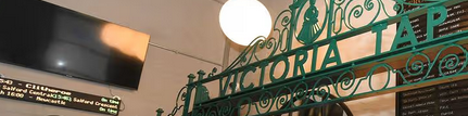
A surprising number of pubs near stations in the UK have them now. The picture above (a detail from this Manchester Evening New article) is from the Victoria Tap in Manchester.
A search of the OSM data in the UK** finds a few, but I’m sure that there are more. A web search finds a bunch of suppliers, and many of their “here’s what you could have in your pub” examples are clearly in the southeast and southwest of England, so I’m sure that there are more to be mapped!
** That’s a simple postpass query:
{{data:sql,server=https://postpass.geofabrik.de/api/0.2/}}
SELECT osm_id, tags, geom
FROM postpass_pointpolygon
WHERE tags->>'amenity'='pub'
AND tags->>'departures_board' is not null
AND geom && {{bbox}}
e.g. A place called “FooBar” should show up when you search for “Foo Bar”, or “Foo & Bar’s” should appear for “Foo and Bars”.
Note the space, ampersand, and apostrophe which may affect a search engine but are not pronounced in spoken English.
Is there a tag that the search engines pick up where I can put those variations? I notice that CoMap’s search engine is pretty good, but the search on openstreetmap.org is a little more strict.
Posted by TrickyFoxy on 31 January 2026 in English.
Last updated on 1 February 2026.

Exactly a year ago I summed up the results in diary of my work on the script, it’s time to do it again.
You can view existing features of the script and install it on GitHub (⭐️ welcome :) or in the OSM Wiki
🛰 Custom map layers
Can be configured in the right side menu or by pressing shift + S.

Satellite images are finally working in Chrome.
It is now possible to customise not only backgrounds, but also vector styles shift + V (but there is a caveat for Chrome users )
I just created OpenMediaMap, an openly-editable map of old photo (pre-1930) locations.
I thought some fellow OSM editors who are also interested in history may find this cool. I also chose to use OSM as the background for the site.
Anyone can add a photo from any source whatsoever, and the goal is to build a visual historical map of how our towns and neighborhoods once looked.
Give it a look and perhaps add a few photos to the map! Feel free to provide suggestions for improvements, as well. :)
Here is the link: https://openmediamap.com/
Posted by luke_unknown on 28 January 2026 in English.
Last updated on 1 February 2026.
Model buildings along the grid, after each grid add accessible parking and crosswalks, levels, addresses, alltheplaces, and wikimaps, then adjust roads and add streetside and zoning. I will later add lanes
add street lamps, check sidewalks, and add street signs and fences
add businesses ect.
survey area to find missing details
add neighborhoods to Evansville, each added once that neighborhood is complete
add neighborhoods to Newburgh, likely no borders only points
এই ম্যাপিং কার্যক্রমে রাজশাহী জেলার বাগমারা উপজেলার নাগা বাজার এলাকাকে কেন্দ্র করে মাঠপর্যায়ের তথ্য ব্যবহার করে OpenStreetMap হালনাগাদ করা হয়েছে। এতে নাগা বাজারের নিকট অবস্থিত একটি ইসলামি শিক্ষা প্রতিষ্ঠান (মাদ্রাসা), অবস্থান ও প্রাসঙ্গিক ট্যাগ যুক্ত করা হয়েছে, যা স্থানীয় শিক্ষার্থী ও পথচারীদের জন্য সহায়ক হবে।
Second day of “quick” weekend project.
Frankly, I’ve run out of interesting things to map around my immediate surroundings. During the holiday season I travelled around the countryside and noticed long stretches of cycleways running alongside highways, occasionally featuring benches, bins, and similar roadside infrastructure. On one trip I tried mapping a rural street using EveryDoor, but the result was similar to summer cycling: frequent stopping dropped my average speed by 10–15 km/h.
I needed a solution where I could mass-save coordinates while moving, and deal with proper mapping later. Vespucci’s copy-paste workflow is probably the closest thing in the OSM ecosystem, but it still requires first tagging a node, then tapping the correct spot on the map. If the map is accidentally dragged, follow-position mode is disabled, and changing the type of copied element requires tagging a new node.
After concluding development I was suggested OsmAnd may support something similar.
I’m android user, so the problem was phrased as “Is there some Android app with a super fast UI for saving coordinates?”
A quick search showed that virtually no existing apps allow bulk bookmarking of unnamed unorganised coordinates My intention was save location something i could later properly map from aerial images. Most apps seemed to require at least 2-3 taps to save position, often with typing bookmark name.
Functional requirements
For time estimates and comparison I used my typical summertime EveryDoor mapping experience. Potential mapping-assisting app should consider these points:
Today, uBlock Origin detected 2 trackers. There was an attempt to fingerprint my GPU by extracting canvas data. What is going on, OSM? Is this why I’ve been donating you my free time? Maybe you’re not so better than Google after all…

A Mapathon has been organised for Saturday 21st February 2026 from 11am to 1pm in Belfast. Pizza will be provided at QUB Geosciences building on Elmwood Avenue behind the Student’s Union. Numbers are limited to 30 attendees.
Sign up on eventbrite here: https://www.eventbrite.co.uk/e/belfast-openstreetmap-workshop-tickets-1981332125724
Event Location: osm.org/#map=19/54.585251/-5.939057
Posted by Dublin Salsa Academy on 22 January 2026 in English.
I have been trying to mark my business on openstreetmap it is already there on google maps. I have a question if anyone can answer please.
Do it need to connect google my business with bing places

I’ve dabbled with overpass turbo on and off for maybe a year now, but I feel like I’ve just now started to get a better understanding of how it works.
I’ve been using it to find hikes that can lead to ruins or abandoned places:
(
nwr['abandoned']({{bbox}});
nwr['historic'='ruins']({{bbox}});
);
out;
and for campsites:
(
nwr['tourism'='camp_site']({{bbox}});
nwr['tourism'='camp_pitch']({{bbox}});
);
out;
And while those are certainly useful, especially for hard to find places that won’t show up on AllTrails or other popular spots, I didn’t feel like I learned much since they’re fairly simple queries.
The way I understand it at the moment: the Overpass query language treats things as sets. There is a default set (named “_”) that gets populated with the queries.
In the case of the camping, there are two lines enclosed in parentheses which groups the two requested object sets as a union (or OR operation) to store in the default set which is then output with the “out” statement
The “nwr” is a shorthand for “node” “way” “relation” so it indicates what kinds of objects we’re looking for (we could replace it with any one type depending on what we’re looking for).
The ({{bbox}}) portion indicates where to look for the objects, {{bbox}} is a predefined area based on the overpass turbo site’s map, otherwise it should be set to a 4-value array indicating the borders of the area to search (read more here)
Let’s break down the next query I’ve found to be very useful, finding local cafe’s! (Google’s results have been getting pretty bad and overlooking a bunch of great options)
[out:csv(
         name,
         "addr:housenumber",
         "addr:street",
         "addr:city",
         website;true;",")];
nwr['amenity'='cafe',i]["name"!="Starbucks"]({{bbox}});

out;
There’s a couple familiar things there: “out”, “({{bbox}})”, and “nwr”
nwr['amenity'='cafe',i]["name"!="Starbucks"]({{bbox}});
Posted by FRANCIS NDIRITU on 19 January 2026 in English.

Years of Growth and Community Impact
I joined the Humanitarian OpenStreetMap Team with a simple interest in mapping, not fully aware of how profoundly it would shape my personal journey and the growth of the OSM Kenya community. What started as basic mapping tasks gradually evolved into deeper involvement in humanitarian mapping, data quality, and community-driven impact.
Over these years, HOT has played a critical role in strengthening my technical skills and perspective on geospatial data. Through initiatives such as the ESA Hub Validation Fellowship, I progressed from mapping to advanced validation and third-pass quality assurance, where accuracy and data integrity are paramount. I contributed to humanitarian projects in Sudan, supported disaster response mapping for Hurricane Mellisa in Jamaica, and worked on local risk-reduction initiatives such as the Elgeyo Marakwet landslide mapping project. These experiences highlighted how reliable geospatial data directly supports preparedness, response, and resilience.
HOT’s impact has extended well beyond individual growth to the wider OSM Kenya community. Through continuous collaboration on HOT Tasking Manager projects and capacity-building programs like FAir, our community has improved technical skills, strengthened quality standards, and fostered a strong culture of mentorship and collaboration. In addition, OSM Kenya has partnered with HOT on thematic campaigns that address social as well as physical vulnerabilities. One notable example is the Mental Health Mapping Campaign, where our community collectively contributed to mapping essential services that support mental health awareness, access, and inclusion demonstrating that humanitarian mapping goes beyond disasters to support overall community well-being.

The page contains all OSM data for the period up to 2026-01-14
Earlier this week, I accepted a PR to our codebase that made a bad and duplicated phone numbers. What happened was, that we use contact:phone=* per convention, but many entries used phone=*, which was not detected by our dupe scanner.
That’s 100% on me. I should have been more vigilant on that one, should have checked better (the few I checked on did not have phone=, so that’s another lesson for the books), and should have checked more vigilantly afterwards as well.
What I did: wrote a rescue to check all 600 edits we did, removed phone= dupes, and moved all phone= that were still there to contact:phone= in the process.
We also do contact every albergue we list (and thus sync) and ask them about their preferred/working phone numbers. So we went ahead and removed stale numbers that no longer worked, and updated those that did to a fully working set.
Of course the code is now fixed as well, and all edits have been too. Sorry again, this is 100% on me.
I’ve run into a strange behaviour in my OSM user diary entry when documenting a batch/ffmpeg command.
This line in a code-block (ignore formatting):
ffmpeg select=eq(pict_type,I)</br>
is automatically turned into:
ffmpeg https://wiki.openstreetmap.org/wiki/Tag:select=eq(pict_type,I)
This happens even inside code blocks (<pre>, fenced code, etc.). It does not happen if I add spaces around the = (e.g. select = eq(pict_type,I)), but I cannot change the code because it must stay exactly as written.
<nowiki>...</nowiki>, <pre>...</pre>, <nowiki><pre>...</pre></nowiki> and similar combinations do not stop the autolink.
Is this a known issue with the OSM Wiki parser or is this a feature?
In order for OpenStreetMap to thrive, we need to attract and retain new mappers. To be welcoming to newcomers, we should avoid high barriers to starting mapping and instead support contributions that can be made with limited time, context, and experience. StreetComplete is a great example of this approach: by asking simple, well-scoped questions, it enables contributors to improve data quality in small, incremental steps. An effort-inclusive tagging philosophy builds on this idea by encouraging tagging schemas where each additional piece of information can be added independently and still be useful on its own. For example, amenity=bench is still a bench regardless if mapper knew about backrest=* and armrest=*.
I am writing this because I have encountered cases where newcomers are advised to follow practices that I consider unnecessarily demanding for basic contributions. A particularly stark example appears in the context of CCTV and ALPR mapping, where a sub-community recommends mappers to take high-resolution photographs, research manufacturers and exact models at home, and consult product datasheets for adding a single camera to OSM. While such detailed work can be valuable, it not only risks discouraging participation, but also makes incorrect data harder to detect if mapper misidentifies the model.
In Fall 2024, I broke my radius (arm) at the wrist of my dominant hand, and didn’t map at all for 2 months, gradually picking things up as my arm healed and gained strength. It was agonizing to not have my daily OSM fix - and a palpable relief when my wrist could once again handle an extended session with a mouse.
Not content with my previous mapping outage, in Fall 2025 I had a cancerous tumor in my parotid (cheekbone salivary gland) removed - except that a relatively straightforward 2 hour surgery turned into a 13-hour marathon and an overnight hospital stay ballooned into 8 days in a hospital bed. The cancer had spread to lymph nodes, to one of my jugular veins and into muscle tissue in my neck. Recovery from the surgery turned into immediate chemotherapy + immunotherapy and radiation.
So now I map when I’m able, which unfortunately is not very frequently. My #Mali project gathers dust, with almost all of my current OSM edits focused around related work with my one remaining freelance client. There does appear to be light at the end of the tunnel (I’m pretty sure it’s not a train). My body has responded well to treatment, and there’s talk of moving me off chemo and onto straight immunotherapy. Looking forward to that possibility.
All of this to say: treasure the time you have. If the difference you make is measured in your OSM edits, then by god make those edits. But more importantly, if the difference you make is measured through those around you that are intertwined into your life, make sure you give sufficient time to them. Your life-changesets are important too.
The More You Know…… ;)
GR