Posted by w_djatmiko on 16 November 2025 in English.
Last updated on 17 November 2025.

Disaster Respond Desa Cibeunying Kecamatan Majenang Kabupaten Cilacap
| Topographic Map Cilacap - BIG |
Disaster Respond Desa Cibeunying Kecamatan Majenang Kabupaten Cilacap
| Topographic Map Cilacap - BIG |
I’ve been tagging my local area for the last 2 years, and where I live, there are areas which are small yet notable, often past plantations or well known locations usually with origins in colonialist’s estates. For example, Clement Hill was a plantation centered on the house called Mound Court, where Benjamin Clement and his descendants once did their business. As such, the location got called Clement Hill. Similar things happened with Viewmont, New Glasgow, Green Hill, etc. What has confused me though is how to tag these locations. Despite all being the same sort of thing, they all get treated differently, even between maps. Yet they are all single notable locations, either inhabited or not, centered around tracts of land where farms or plantation houses were or are present. There are multiple tags in OSM that cover similar ideas, such as: 1. a locality 2. an isolated settlement 3. a plot 4. a farm 5. a named house 6. a residential area 7. a historic location And as I said, maps treat them differently. Some maps treat them as residences while others highlight them like they do hamlets and towns. Sometimes the location is specified as the name of the plot while other times it’s referring to the general area instead. So how do you tag all these similar yet different locations? I’d like an unambiguous “plantation” or “estate” location tag which signifies that the location: 1. is or was a place where an estate was located. 2. is used like a general settlement name . 3. is between a farm, a plot, and a locality or isolated settlement as not all of these locations are exactly any of them. 4. but conveys the one idea of a significant plantation or similar settlement, either existent or no longer existent, that can be surrounded by smaller residences or be a lone estate, as these 2 scenarios are common in rural Virginia and are both considered the same sort of thing.
It’s been a while since I posted, and we’ve been working hard in the background to add more (and safe) OSM contributing. Since last we spoke, we’ve actually been in court, defending ourselves against a “competitor” (I wouldn’t consider us competitors, we’re in the same space but they’re for-pay and we’re Libre, Open Source, Open, and Free) who claimed we “stole” their data.
Funnily enough, “their” data seems to come straight from OSM. When I contributed an albergue a while back, I made a typo (è instead of é) and it’s in their dataset. So, yeah, we won, they paid, and they cried. Cheaters always accuse others of cheating.
We renamed ourselves from Camino Now to Ultreia.me, because another competitor didn’t like the fact that we had “Camino” in the name and sued as well.
There is a LOT of money to be made with those apps, which is why they all hate being threatened by a free/libre alternative.
Anyhow, we now sync hostel data back. Mainly telephone numbers, opening hours, wheelchair access, kitchen access, washer/dryer, those things.
Individual Residential Area
The goal of this project is to improve address coverage in the City of Brampton on OpenStreetMap by verifying and adding missing address information using open data provided through the Brampton GeoHub. The DATASET includes authoritative municipal address points, which serve as a reliable source for accurate street names, house numbers, and related attributes.
Data Source: - Dataset: Municipal Address Points - License: Creative Commons Attribution 4.0 International (CC BY 4.0) - Attribution: “Contains information licensed under the Open Government Licence – Brampton.”
Scope: - City of Brampton only - Single-family dwellings and clearly matched building polygons
26 Nov 2025, Edit: Project paused until a suitable dataset with a compatible usage license can be obtained. Thank you to users pointing out the Brampton license may not cover OSM usage.
About eight months ago I started mapping my hometown, and earlier today I reached a major milestone of having gone over everywhere boxed in by the Sabine River Diversion Canal and the CPKC railroad. I’ve gotten a lot more detailed and generally more accurate with mapping, so rather than moving on I’m going to do a (hopefully much quicker) second pass, particularly for where I did not yet start using street-level imagery to verify road names, building/business names, and other micromapping targets I like to do (an embarrassing number of power poles and street lamps). I expect to have every road de-tigered and every visibly signed POI named sometime next year. From that point on I think I’ll focus on de-tigering the rest of the road network in the parish, then maybe start mapping other nearby towns.
As part of the Ireland chapter of OpenStreetMap a few years ago I set up a tileserver and a map frontend that defaulted to showing placenames in the Irish language (Gaeilge). Recently I spent some time improving both these services.
Previously the default style was named ‘ga’ and available at: https://tileserver.openstreetmap.ie/styles/ga However, last weekend I added a new ‘style’ named ‘sraid-v1’. You can take a look at it here: https://tileserver.openstreetmap.ie/styles/sraid-v1/ The screenshots below show a comparison. The new style is much brighter and has icons generated from Maki icons into a sprite sheet (see generate_sprites.py in the github repo). I also fixed a few things I didn’t like about the old ‘ga’ style.
If you are currently using tiles from tileserver.openstreetmap.ie and want to use the new ones, you will need to change the code where it currently points to:
https://tileserver.openstreetmap.ie/styles/ga/
You can now use:
https://tileserver.openstreetmap.ie/styles/sraid-v1/
So to use this vector tileset you might use something like the code below with MapLibreGL
var map = new maplibregl.Map({
  container: 'map',
  style: 'https://tileserver.openstreetmap.ie/styles/sraid-v1/style.json' + keyParam,
  hash: true,
  maxPitch: 85
});
The previous style ‘ga’ is still present so there should be no breaks in functionality if you choose to continue using the old style.
The code is available here: https://github.com/jonnymccullagh/irish-language-osm-tiles
Dear OSM users,
I need to inform you that, unfortunately, the Toledo Province area is quite neglected and lacks detail. This isn’t anyone’s fault, obviously; it’s something that needs improvement, and together we can fix it. Furthermore, one of the most populated areas of Toledo, the La Sagra region and its surroundings, lacks updates and good features. We also cover the southern Madrid area, which also lacks updates.
WE NEED PEOPLE WHO CARE ABOUT THIS AREA.
LET’S DO SOMETHING BIG.
Thanks for reading.
I was checking the map in all of the world and i see things that broke my eyes. I never been there but the things i found are don’t common.
I had to add so many things to this place during my courent day in the job. I need someone that with me add to Getafe some things that there aren’t on the map. Please, write me in private to let me now who want to colaborate in this proyect that is name: Lets help Getafe!!!! Let me now who is interesed writting me. I will read your menseges. Bye Kitsunderoku
More recently I find myself addicted to OSM once more after a long hiatus. I guess working in the civil road design space has me interested in capturing features around the streets such as crossings, sidewalks, street furniture and recreation spaces.
I’m shocked by the number of sidewalks I have found that cross a street not as a crossing. I’m fixing these as I find them.
My end goal is to try and resolve as many items from StreetComplete as I can around where I live and work, adding to the accuracy of the overall map model locally.
Collaborating to add verified information to OpenStreetMap can significantly improve global navigation and community planning. I am a firm believer that each contribution helps create a more accurate, accessible, and connected world. Together, we can truly make a difference!
LostAlone
Having grown up in the Current River Area there are many same details I was able to add to the map such as small back roads that are mainly used my locals. Additionally one thing I noticed with is that many features where outdates. There where restaurants and stores that closed down years ago and new ones have since opened up in their place. So I updated the map to have the newest data. From using openstreetmap I learned a lot about citizen mapping and the people who live in an area know it the best to map it. But also using a mapping website open to the public comes with risks of inaccuracies. What I found to be challenging was that some houses weren’t properly lined up so it impacted when I tried to add a new house.
… and following on from the previous entry, Maps for Garmin devices at map.atownsend.org.uk now show crossing details too:
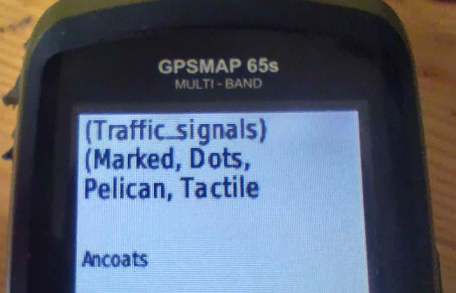
The following tags from the top-level feature are shown:
traffic_signals or crossing
crossing if it adds extra informationcrossing:island, crossing:marked, crossing_ref etc. if they add extra information.tactile_paving and kerb.All of this might be truncated for length (it is here), but the most important information does appear.
I am a new editor of OSM, and I thought I would explore the tools and update familiar areas for myself. I added and updated areas in Bronte Creek Provincial Park. The OSM tools made it really easy to add new areas, points of interest, add some walking trails and label everything with accurate details. The park was already mapped with buildings, trails, roads, parking lots and much more. A lot of what I found myself doing was adding newly labelled areas, ex. Cow Barn, Cow Pasture. I am very familiar with BCPP, and now anyone looking to go to the park can have a better idea of what is really there. OMS is very easy to navigate, and I enjoyed using this mapping software. Not only is it a great tool to add for other people to use, but it is also great to see what is really in your surroundings.
Ok, my good friend Butterball wanted to pay me a visit from Bree. You all know how he is, super braggy. He told me he just got a brand new iPhone version 1 with 20 KB of RAM. I was like, “Okay, cool, Butterball. We’ll see you. Just don’t be braggy.”
He wrote me a long letter promising me that he wouldn’t be braggy, but then he told me about a problem that he had. He had too many footpaths coming up on his map. He couldn’t find the way easily. Every time he brought up the map, his iPhone crashed. Check out the shire with all of the footpaths!

I told him, “Don’t worry, I’ll just modify his map with a new layer with just roads on it instead of all the other extra crap.”
I was like, Open Street Map is pretty awesome, but they include a lot of stuff in their layers, and then they let you just claw back what you want. I think what we want to do is modify it so we only show the tags that we want, so your map doesn’t crash. Does that sound like a good plan?
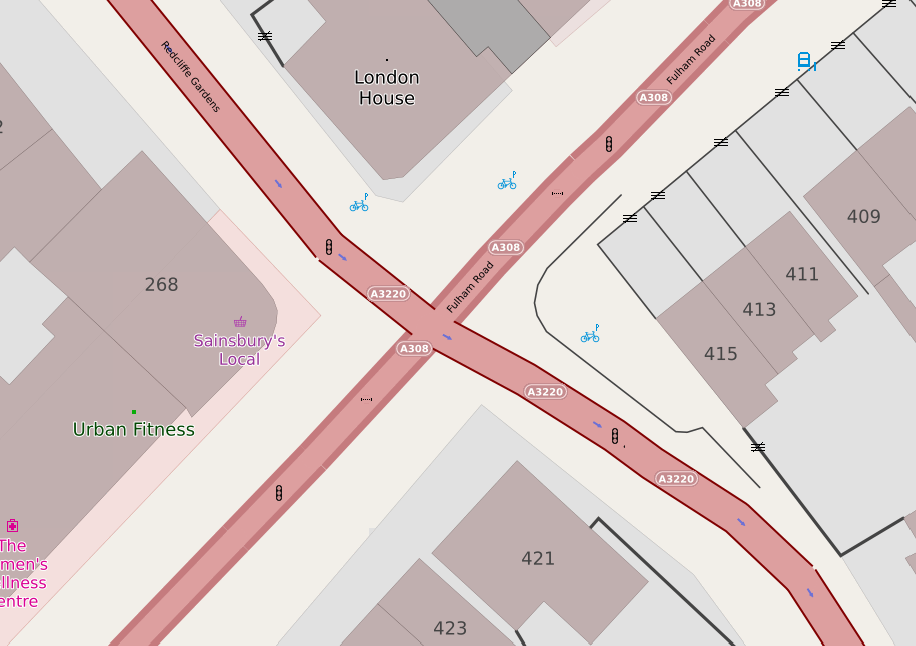
I have a couple of web maps, and they are supposed to show pedestrian crossings. If there’s some crossing infrastructure (for example - zebra stripes, or tactile paving and a lowered kerb) you’re supposed to see a “crossing” icon. If there are traffic signals associated with the crossing, that icon should be replaced with a “traffic signals” one.
Years ago it was straightforward - you’d get a highway=crossing tag on a node on the roadway, and there would be another tag, such as crossing_ref to say what sort of crossing it was. Some crossings (such as pelican, puffin and pegasus) have traffic signals; others (zebra and informal crossings) tend not to.
Unfortunately, it has got a lot more complicated.
Sometimes, the highway tag is crossing;<something> or <something>;crossing. Sometimes that something should be ignored and treated as a crossing.
One of the most important things I learned about mapping with OpenStreetMap is how collaborative and detailed the global mapping community is. Every edit, no matter how small, contributes to a shared, constantly evolving map that supports navigation, humanitarian efforts, and local development. I realized how crucial accuracy and verification are, each feature needs to be placed and tagged correctly so that it’s useful for others. The most challenging part of editing OSM was learning the tagging system and ensuring that my edits followed mapping conventions. I mainly mapped in areas that lacked detailed data. Overall, the experience showed me how open data and collective participation can create powerful geographic resources that benefit communities around the world.


