I continued on with the Happy Valley work, and found that I was able to do a portion of Johnny Hill Road.
I’ll be continuing on at this new pace.
I continued on with the Happy Valley work, and found that I was able to do a portion of Johnny Hill Road.
I’ll be continuing on at this new pace.
Covered one side of Johnny Hill Drive between Hefler and Garland Street.
There has been a recent surge of interest in mapping walking infrastructure in Melbourne. This is very exciting because many parts have been lacking for a long time.
I have been adding some things piecemeal over the years. Recently I have made a more concerted effort to get footpath and crossing data into the Map. Several other users have been doing a huge amount to make this happen.
Here I wanted to briefly share a summary of my approach to mapping these footpaths and crossings. As is custom for OSM, this is not prescriptive at all; just a description of how I am approaching this task. It is based on consistency of edits and consistency with existing and new data.
highway=footway
footway=sidewalk
I am also including the surface where known. Most footpaths are built of concrete, especially in older suburbs. The next most common would be asphalt, but there are still some unpaved footpaths - even in built-up areas. I think this is important to include for accessibility and route planning.
surface=concrete
One important aspect here is that I am mapping footpath ways separately to the crossing ways. Which brings us to…
highway=crossing
crossing=*
crossing:island=*
crossing:markings=*
Here is an example of a simple T-intersection that shows my general approach to mapping ways for footpaths and crossings separately.
In Japan, when you buy tobaccos from a vending machine, you first have to prove that you are 20+ years old. Since 2008, The Japan Tobacconist Federation has been issuing “taspo” smart cards to adult smokers. You can apply these cards to cigarettes vending machines to activate them. Back in 2008, 97% of the vending machines supported taspo for age verification.
Due to technical limitations, taspo system was announced to be shut down in March, 2026, and some vending machines are now retrofitted with new age verification modules that accept a driver’s license card, “My Number Card” (which is officially called Individual Number Card in English), and/or passports (ref: list of government-recognized age verification modules for cigarettes vending machines).
I started to tag taspo-compatible vending machines with authentication:taspo=yes, and those with the other verification methods with authentication:JP:driving_licence=yes, authentication:JP:individual_number_card=yes, or authentication:passport=yes, respectively.
I added another set of buildings on Hamel Street and Garland Street. Had to also fix some naming issues on Hamel Street
A collection/showcase of the different buildings and areas that I have mapped in 3D (through much trial and error). Each location has a link to view on OSM where you can see what building parts and tagging I’ve used to represent these buildings. The heights I have tagged on building parts are mainly calculated by working out the ratio of a building’s height and width in a photo (I used paint.net to measure these dimensions in pixels) and applying this to the width that can be measured from aerial imagery.
I added several more houses sheds and garages to the Happy Valley Goose Bay area. I think that i will try to add more to other areas shortly, and speed up my time to a street a day so that I can start on other communities sooner.
Recently Malaga’s bus route number 37 was extended to Residencia Santa Clara in the hills outside the city. This part of the route had been suspended for a few years, and I knew that some stops had been relocated in the meantime. So I took the bus to the last stop to update the mapping in OpenStreetMap.
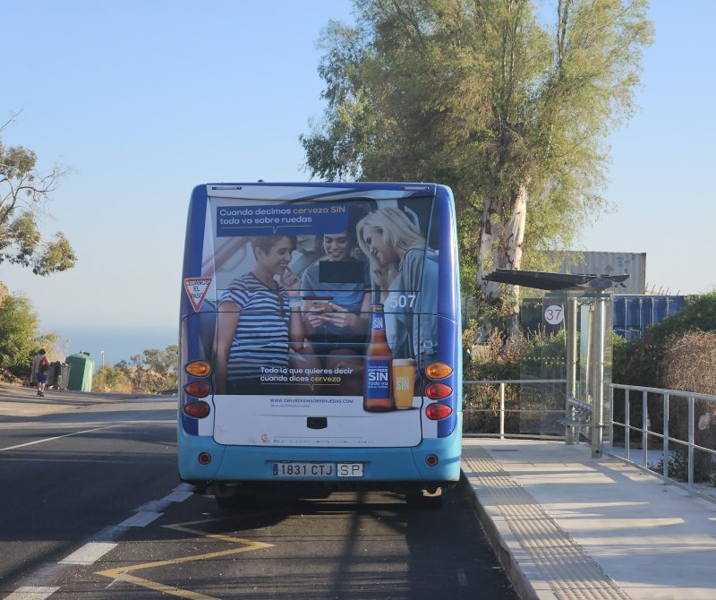
As I walked back towards the city down a steeply sloping road (pausing to tag it as sidewalk=no), I wondered if I had just visited the city’s highest bus stop. I could probably have confirmed this fairly quickly with the help of a relief map - there were only a few realistic candidates.
But I happened to be looking at the OSMnx Python package for unrelated reasons. And I had already downloaded Digital Terrain Model files covering the city of Malaga. Obviously destiny wanted me to take a library intended for analysing important questions about urban road networks, and use it to devise an over-engineered answer to my trivial question about bus stops.
Newark Fence Co is a townhouse complex in Rosenberger Dr, Middletown, DE 19709
Completed
💕 osm.org/relation/1155266/history/177
💕 https://osm.mapki.com/history/relation/1155266#version-1
27 July 2025 at 09:30
I added several extra parts to Hamel Street, which I had to name, because apparently there hadn’t been a name available on it. I added several houses, and will add more soon.
I added data to the Mauritania mapping for the agricultural component of the UN. Most of these appear to have been a result of the shape of the landscape, around the farmland.
I think that next time I will use the Josm tool.
A style using the Shortbread vector tiles is now live on OpenStreetMap.org. There’s been some minor issues with the roll-out, but nothing that caused me to panic. I’ve been taking a couple of days to unwind and relax, as this has been a major milestone.
A feature like this includes work across multiple projects, so people have been asking where to report issues.
Any issues that are present on the OpenStreetMap website but not on the vector demo page should be reported to openstreetmap-website. Some issues reported have been with attribution controls and strange panning at extremely high zooms
Style issues (e.g. colors, symbology, fonts, etc) are handled by the VersaTiles Colorful and VersaTiles Eclipse styles. Both can be found in a VersaTiles repository.
What is supposed to be in the tiles is defined in the Shortbread Vector Tile Schema 1.0. There are lists of what features should appear, and where they should appear.
The code responsible for what is actually in the tiles is contained in the Street Spirit repo. If something is missing that is supposed to be in Shortbread, this needs fixing. This also handles simplifcation and other parts of generating the tiles.
The software that serves the tiles is Tilekiln. If the wrong HTTP headers are being sent, this is where you report it.
The chef code pulls everything together on the OSMF servers. It’s unlikely you should report an issue directly here.
Some font rendering issues are part of MapLibre GL JS. This is most likely to come up in Southeast Asia.
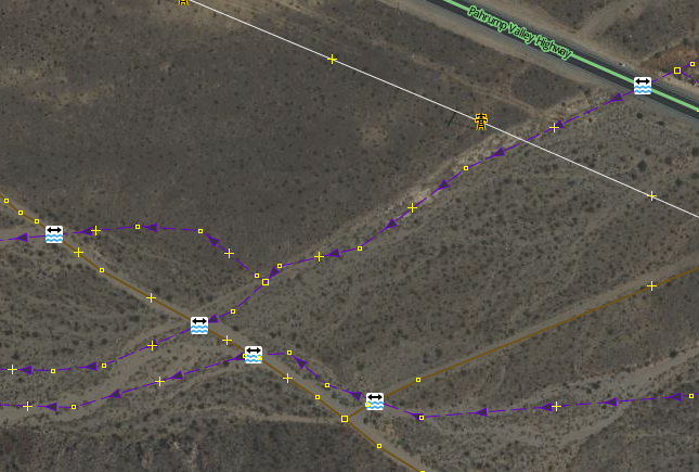
Many OSM validators will report an error if a waterway crosses a highway without some additional tags or structure at the intersection, such as a bridge, culvert, or ford. That makes a lot of sense if you’re working in an area where the roads and waterways are already well mapped and where the waterways are actually wet. Those assumptions might work well in Europe, for example. They don’t work well in the Southwest United States.
Of the possible resolutions, adding a node with ford=yes is the easiest, so many mappers will do this to satisfy the validator – sometimes without looking closely at the situation. Then you get results like this, where the ford=yes nodes are meaningless.
If you get a warning from a validator that a waterway and highway intersect and need additional tagging, there are some things to consider first:
I like to map trees. Last year, I wrote a diary about trees mapping, a wiki page to document tagging of Italian monumental trees tagging, a trivia thread about the tallest trees in the database etc. In this diary, I’d like to focus on quality assurance (QA) checks we can perform on tree data. Many of these checks have been turned in MapRoulette challenges in my Tree Validation project.
The circumference=* tag is used to describe the circumference of a tree’s trunk at a height of 1.3 metres above the ground, with the implied unit of measure being metres. Therefore, circumference=2.3 describes a trunk with a circumference of 2.3 metres.
According to the Guinness World Records, the greatest circumference for a tree is 43 metres. Trees with circumferences exceeding this value are likely errors. Often people forget that metres is the standard unit, so they tag using centimetres, creating giant trees. E.g. they tag circumference=650 instead of circumference=6.50.
The height=* tag is used to describe the height of a tree in metres. Therefore, height=15 describes a tree that is 15 metres tall.
Hyperion is a coast redwood (Sequoia sempervirens) in California that is the world’s tallest known living tree, measuring 115.92 m. Trees with height exceeding this value are likely errors.
You can refine the above checks using known limits for individual species. For example, according to monumentaltrees.com, the biggest circumference for a Tilia cordata is 12.81 (instead of 43) and the tallest specimen is 41.60 (instead of 115.92).
The height-to-circumference ratio can be considered a form of “slenderness ratio”: lower values indicate stocky or stout trees, while higher values indicate slender or spindly trees. This can be helpful to find wrong circumference or heights.
Slowly working to edit and add information about public infrastructure, along with surveillance information.
I haven’t written anything in this diary yet, so I decided to just do that.
I have no idea any more when I first heard of OpenStreetMap. What I do still remember is the time where I didn’t know how to make changes myself. I noticed this mostly back around 2015 when I was using a GPS navigator based on OSM data, and often it didn’t bring me to the precise location because of missing house numbers. This wasn’t too bad, I was in the general vicinity, and I could mostly figure out where to go from there, but it was annoying, and I do remember two occasions where the same street was actually separate parts, making it hard to find out where I needed to be. I was thinking that it would be nice if I’d knew how to add those house numbers. Some I encounter along the way wouldn’t be much, but if everyone does a bit, a lot can be done was my idea.
Somewhere in 2021, I met Pieter who is very active in the Belgian OSM community, and he was nice enough to give me a deep explanation of how it all works and what tools there are and what I can do to contribute. I decided to write this explanation down in a blog post, and from that moment on, I started to contribute to OSM. I was also pleased to hear that the house number problem I was having, was mostly a problem of the past, as the government released the needed data under a compatible open license, and people of the community are making sure the data is put to good use.
Al Nabi Colony, Gujrat, Punjab, Pakistan Sells groceries, snacks, and daily household items. This is a physical and actively operating business.
April 15–19, 2025, proved to be a special landmark in my mapping experience when I participated in the OSM Spring Mapathon 2025, sponsored by Youth Innovation Lab. I am excited to announce that I won the Beginner Category for 22,922 map changes!
This acknowledgement is meaningful to me—not only as a personal achievement, but also as a personal reminder of my growth since first hearing about OpenStreetMap (OSM) during 2021. At that time, OSM was merely another name, still learning its way into my periphery. Little did I realize the meaning that OSM would take on as an important part of my learning and contribution trajectory.
I committed a certain amount of time each day during the Mapathon to updating map data. Anything from adding roads, perfecting building footprints, or fixing map glitches and errors. Each change adding to a sense of satisfaction that somewhere someone would benefit from finally going through something that they could map out into a community, and their community becoming visible, sharing their data.
The event itself was inspiring. While Youth Innovation Lab was the primary host, the Mapathon brought together fellow mappers from across the land, and beyond. Each day’s schedule created an exciting and competitive environment that made staying sedimentary contagious.
Though I did not expect to win the Beginner Category, I am even more so grateful. The motivation of this experience is further proof that with the appropriate due diligence, sprinkling curiosity and learning, anything is possible!


