Diary Entries in English

Recent diary entries

I haven’t written anything in this diary yet, so I decided to just do that.

I have no idea any more when I first heard of OpenStreetMap. What I do still remember is the time where I didn’t know how to make changes myself. I noticed this mostly back around 2015 when I was using a GPS navigator based on OSM data, and often it didn’t bring me to the precise location because of missing house numbers. This wasn’t too bad, I was in the general vicinity, and I could mostly figure out where to go from there, but it was annoying, and I do remember two occasions where the same street was actually separate parts, making it hard to find out where I needed to be. I was thinking that it would be nice if I’d knew how to add those house numbers. Some I encounter along the way wouldn’t be much, but if everyone does a bit, a lot can be done was my idea.

Somewhere in 2021, I met Pieter who is very active in the Belgian OSM community, and he was nice enough to give me a deep explanation of how it all works and what tools there are and what I can do to contribute. I decided to write this explanation down in a blog post, and from that moment on, I started to contribute to OSM. I was also pleased to hear that the house number problem I was having, was mostly a problem of the past, as the government released the needed data under a compatible open license, and people of the community are making sure the data is put to good use.

See full entry

April 15–19, 2025, proved to be a special landmark in my mapping experience when I participated in the OSM Spring Mapathon 2025, sponsored by Youth Innovation Lab. I am excited to announce that I won the Beginner Category for 22,922 map changes!

This acknowledgement is meaningful to me—not only as a personal achievement, but also as a personal reminder of my growth since first hearing about OpenStreetMap (OSM) during 2021. At that time, OSM was merely another name, still learning its way into my periphery. Little did I realize the meaning that OSM would take on as an important part of my learning and contribution trajectory.

I committed a certain amount of time each day during the Mapathon to updating map data. Anything from adding roads, perfecting building footprints, or fixing map glitches and errors. Each change adding to a sense of satisfaction that somewhere someone would benefit from finally going through something that they could map out into a community, and their community becoming visible, sharing their data.

The event itself was inspiring. While Youth Innovation Lab was the primary host, the Mapathon brought together fellow mappers from across the land, and beyond. Each day’s schedule created an exciting and competitive environment that made staying sedimentary contagious.

Though I did not expect to win the Beginner Category, I am even more so grateful. The motivation of this experience is further proof that with the appropriate due diligence, sprinkling curiosity and learning, anything is possible!

HOT#OSM#Youth Innovation Lab# OSM Spring Mapathon2025

Posted by anqixu on 21 July 2025 in English.

Hi guys!

Quick midterm update from me! Just as a little refresher, my name is Anqi and I’ve been working on the Transliteration of Search Results project this summer.

Time has really flown by and we are at the halfway point! Here I hope to give a summary of the work that’s been done so far, as well as what I hope to accomplish during the next part of the summer! We want to be able to return the transliterated name as a field during search results, with a proof of concept shown here! We can see in this proof of concept that the results are as expected, with the addition of one transliterated name field.

{
"place_id":100067,
"licence":"Data © OpenStreetMap contributors, ODbL 1.0. http://osm.org/copyright",
"osm_type":"way",
"osm_id":1307932969,
"place_rank":30,
"category":"amenity",
"type":"school",
"importance":-0.004452559995167061,
"addresstype":"amenity",
"name":"丹东市第六中学",
"display_name":"丹东市第六中学, 七纬路, 站前街道, 丹东市, 振兴区, 118000, 中国",
"transliterated_name":"Dan Dong Shi Di Liu Zhong Xue, Qi Wei Lu, Zhan Qian Jie Dao, Dan Dong Shi, Zhen Xing Qu, 118000, Zhong Guo",
"bbox":[124.3804784,40.1271951,124.3830593,40.1292045],
"geometry":{
"type": "Point",
"coordinates": [124.38176886493923, 40.12819985]
},

The general flow can be visualized as below.

See full entry

Posted by oldnab on 20 July 2025 in English.

RETEX: My Urban Recycling Trekking

To be continued, maybe:

  • diary entry (upcoming): choosing tags for this trekking
  • diary entry (upcoming): existential questions about my encounter with Panoramax

Context

Since April 2025, I’ve been discovering OSM and trying to contribute wherever I can. Needless to say, I’m learning something new every day about OSM mapping (thanks to the Wiki, forum, and fellow contributors).

While exploring my neighborhood, I added a voluntary drop-off point (for recyclable — though not always — waste) to OSM, located 800m from my home. I then discovered that the local intermunicipal authority has an app listing a large portion of the collection points. I wondered whether it was legally and technically feasible to retrieve those, and whether it would align with the OSM ethos.

The forum quickly (and kindly) set me straight (as I said, after only 2 months with OSM, I’m learning a lot every day):

  • Extracting data from a website’s database is obviously illegal unless there’s an explicit license that allows it.
  • Even if there were a friendly license (which is not the case here), it would still need to be ODbL-compatible to import the data into OSM.

This led me to pursue two parallel paths:

  1. Finding a sustainable solution via an open data source, which means:

    • Trying to convince the intermunicipality to publish its data, ideally on www.data.gouv.fr
    • Convincing them to make this publication sustainable (i.e., generate an export every time there are updates)
    • Assessing how, in theory, this data could be used (completeness, attribute matching, duplicate detection, handling conflicts between open data and on-the-ground data — which can either be better or simply incorrectly entered)
    • Finding out how and by whom the data could be imported
    • Seeing if all of this could happen before 2035
  2. Starting manual mapping myself through field visits (the foundation of OSM’s truth)

See full entry

Posted by Zverik on 20 July 2025 in English.

As you might know, we’re having OpenStreetMap Awards this year! Finally, after many skipped years, we will have the honour and the joy to recognize people and teams who have made an impact on OSM, whether it’s by mapping, writing, or coding!

The process is open, and the same as the last time: first we gather all the nominees we can think of, then some groups of notable OSM members will choose a few from those who feel to be the most notable, and after that — an open community voting to choose one for each category. And the categories are:

  • Core Systems Award — for building or maintaining an core project.
  • Innovation Award — for making something new.
  • Influential Writing Award — for blog posts, tutorials and documentation.
  • Greatness in Mapping Award — for tireless mapping!
  • Expanding the Community Award — for finding us more members.
  • Team Achievement Award — awarded to companies and groups.
  • Ulf Möller Memorial Award — like a lifetime archievement award for individuals.

Note that only achievements made or announced in 2024 or before April 1st, 2025 are eligible.

And right now, I need you help. The deadline for submitting nominees is looming, and we’ve got too few. Each category needs at least twenty to make sense, and for some, we got like two.

This needs some archive work. Like, open WeeklyOSM or big community discussions (before April 1st), and add people, projects, and teams you think made the OSM in general slightly better.

And submit them to https://awards.openstreetmap.org/

(Yes, we’ve got the official domain, thanks to Grant!)

Posted by caseywittmier on 18 July 2025 in English. Last updated on 21 July 2025.

July 20, 2025 - After 17 months, I have reviewed every road in the NFSR network for the Siuslaw National Forest. Below is a summary of what was involved and the process I used.

Foundational elements

The foundational elements of this project are two public domain road datasets, the NFSR data from the United States Forest Service, and the OR-Trans dataset from the state of Oregon. NFSR is the reference for road numbers, names given to roads by the USFS, road surfaces, and geometry to a certain degree. The OR-Trans data is a reference for primary road names, geometry verification, and the tag formatting of USFS roads. I was able to use additional GIS from counties to verify geometries and primary road names.

Project management

QGIS was utilized as a way to manage the entire project. I used conditional styles on manually added attributes to break the 1,977 roads from the NFSR data into workable chunks, and to keep track of what I had done. Those workable chunks were exported as KMLs to use as a reference when working in iD.

Edits on OSM

I elected to use iD for this project to force myself to manually review everything I was doing, and to remove the possibility of an accusation of a careless import.

The NFSR data contains good geometry for the most part, but there are quite a few errors that are very significant. The NFSR data also contains several discrepancies from reality, such as roads being marked as closed and not open for use, despite the roads not being gated and definitely being actively used. Blanket replacing the geometry and tags in OSM without manual review would worsen the quality of OSM data.

This was also a good opportunity to do some TIGER cleanup and resolve road/water crossing issues. Unfortunately, with the nature of the crossing issues, resolving one can lead to getting flags for multiple others along the road or waterway, which can make it appear that you are creating these issues even though they were already present.

Tag formatting

See full entry

Posted by tebby7 on 17 July 2025 in English.

In 2020, I was presented with an opportunity to participate in the Humanitarian OpenStreetMap Team’s Data Quality Internship, https://www.hotosm.org/jobs/data-quality-internship/,a twelve-week program designed to facilitate deep engagement within the Humanitarian OpenStreetMap Team and its community while acquiring transferable geospatial skills.

Commencing on August 3rd, I undertook a three-month internship that concentrated on Geospatial Data Quality within the Humanitarian OpenStreetMap Team. The primary objective of this internship was to prepare interns to evaluate data quality, execute mapping and validation tasks, and provide constructive feedback to mappers engaged in HOT’s remote mapping initiatives, which included various activations. This experience necessitated the acquisition and application of both novel and established OpenStreetMap Quality Assurance tools to enhance the quality of data within the OpenStreetMap framework.

-Data Quality Assurance with QGIS

  1. Downloading OpenStreetMap data into QGIS

https://youtu.be/Mvh5l0PiOiE

  1. Editing OpenStreetMap data in QGIS

  2. Using Map Composer

-Mapping and validation on Tasks e.g #8294 and #9194

-Introduction to Overpass Turbo and Umap: filter OSM data, extract/export data

-Improving data quality with Overpass and creating simple webmaps using Umap

  • The graphic interface and tools for creating a basic map layout through the manipulation of vector data

-Quality Assurance Tools such as OSMCha, OSM Inspector, Keep Right and Osmose

-The use of Map Roulette and Map Paint Styles

  • JOSM training i.e mapping and validation using JOSM, task #9055

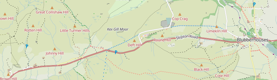
Kex Gill, west of Harrogate

Kex Gill (humorously named the “Côte de Blubberhouses” for a stage of the 2014 Tour de France) is a road in Yorkshire between Harrogate and Skipton. Part of it is gradually sliding down the valley that it is built half-way up the side of and is being rebuilt; it was the access tags on bridleways there that caught my eye in the first place.

See full entry

Location: Blubberhouses, North Yorkshire, York and North Yorkshire, England, United Kingdom

The twenty-fourth development diary marks the most significant milestone in OpenStreetMap-NG’s journey to date: the launch of our public test instance. After months of intensive development, we’re finally excited to show it all off! This isn’t just a technical achievement—it’s a pivotal moment in our mission to revolutionize open-source mapping.

🔖 You can read other development diaries here:
https://www.openstreetmap.org/user/NorthCrab/diary/

⭐ This project is open-source — join us today:
https://github.com/openstreetmap-ng/openstreetmap-ng

🛈 This initiative is not affiliated with the OpenStreetMap Foundation.


Public Test Instance Launch 🚀

OpenStreetMap-NG is now live for public testing at osm.ng. This milestone represents months of intensive development, optimization, and preparation to create a stable testing environment for the community. Every mapper, developer, and OpenStreetMap enthusiast can now experience what we’ve been envisioning as the next generation of mapping platforms.

The test environment runs completely independently from the main OpenStreetMap infrastructure. It features the complete OpenStreetMap dataset while providing a safe playground for experimentation and feedback. You can explore all the functionality without worrying about affecting live data—perfect for giving the platform a thorough evaluation.

Liftoff! We have a liftoff, 32 minutes past the hour. Liftoff on Apollo 11.


CloudFerro Infrastructure Partnership

See full entry

Posted by UrbanRoaming on 10 July 2025 in English. Last updated on 13 July 2025.

OpenStreetMap went viral! Well, sort of.

Screenshot of video described below

A recent Instagram video highlighted an area where Pokémon Go had better trail coverage than Google Maps. You can see for yourself:

Original Instagram Post

OSM Town Mastodon Mirror

Currently, the video has over 12.6 million views and 733 thousand likes!

As you probably know, Pokémon Go uses OSM for its map data. So it’s cool seeing it acknowledged that OSM data performed better, even if it was misguided as a compliment towards Pokémon Go/Niantic.

With a little bit of searching, I found the path that they were on: Way #518694188. Added 8 years ago by BikeRoad.

Posted by KieranW25 on 9 July 2025 in English.

Working independently to help plot missing areas but conscious of the current geopolitical situation. Can anyone recommend if there’s any areas to be mapped out of urgency? For instance Texas with the current floods, Gaza or Ukraine etc for the humanitarian issues and destruction of war. I want my work to have as much positive impact and possible and consequentially don’t want to be plotting somewhere remote in say Africa for instance when actually somewhere else is in a much more urgent and desperate need. Many thanks.

FREE AND OPEN REGISTRATION FOR THE III WORKSHOP ON PARTICIPATORY MAPPING AND SOCIAL CARTOGRAPHY - MPCS 2025


Ler em Português

You can now register for the collective mapping event of 2025. Thank you to everyone who sent their contributions!
We’ll see you in August at the event, which is 100% online and completely open to the public. Registration at:
https://ivides.org/workshopmpcs2025

The actual event numbers are:

  • 133 speakers
  • 36 Projects in the Mapping Exhibition
  • 20 book chapter presentations
  • 9 Special Keynotes with invited experts
  • 1 OpenStreetMap training session + 01 Mapathon
  • 1 book release [90 authors and 20 chapters]

To keep contact: ivides@ivides.org


event divulgation

See full entry