Diary Entries in English

Recent diary entries

Today, I had a good time at the national office and Mapathon center of Unique Mappers Network-the OpenStreetMap Nigeria Community NGO (osm.org/#map=18/4.899962/6.921081) to engage newbies, signing them up and training them on how to contribute to OpenStreetMap. Among them are Ngozi,Fortune,David and Chika (NMak,verified,Peter Msiion D and Victoria Jaja). Please, check out for them to welcome them and share your success stories and motivation for OSM volunteering. Fortune(verifiedfortune) joining Unique Mappers IT cohort 1 for 2025 would be contributing for the next 6 months as part of his IT task. https://www.linkedin.com/feed/update/urn:li:activity:7329531711480926209 ![ ]

On 3rd May, We got back to our Map Nigeria Monthly Mapathon to sustain active OSM community participation in Nigeria, especially as we have mapping projects being coordinated in collaboration with TomTom one of Unique Mappers Network partner https://tasks.openstreetmap.us/projects/815#coordination . Volunteers joined from across the states and universities in Nigeria in a virtual coordinated mapathon, especially, the Unique Mappers Team we recently established in Abuja,Kaduna.Ile-Ife and Enugu.

In the first quarter of 2025, we have mobilized,signed-up and trained more than 100 newbies coordinated in a new whatsaap group of the community whatsaap group for orientation purposes. However, mapping contributions has been quite slow as the recent high increase in internet data subscription in Nigeria makes it more difficult for both old and new OSM volunteers to sacrifice the high cost of internet for voluntary mapping in OSM. You can hardly find free internet broad band access to engage volunteers in Mapathon.

See full entry

Location: Alakahia, Obio/Akpor, Rivers State, 500004, Nigeria

Today 12th May 2025, I got to the place i’m suppose to do my IT, [INDUSTRIAL TRAINING], As at 10am in the morning when asked to come. I met 2 other people David and Ngozi, they welcomed me while i waited for the National Coordinator DR VICTOR .N. SUNDAY of unique mapper. After was, the National Coordinator DR Victor sunday came in, with out wasting much time, another person enter named chika i guess so, so he introduced OpenStreetMap to all of us that were there together. He said a lot of things about the OpenStreetMap, As what we use in carrying out mapping and it’s also free, like a volunteer thing. It was exciting to have DR Victor Sunday, the coordinator teach and talk about the OpenStreetMap, Me been introduce to OpenStreetMap, its not my first time but i was able to get a clear picture of what an OpenStreetMap was all about, which it was intresting, Now i can say i know how to map a building. yoooo!!! With everything that went on, everyone had to practice for themselves on learning how to do the mapping there self, which was cool and right now we are done with the classes on mapping as at 1:56PM, Everyone is expected to sign up with OpenStreetMap and map out at least 10 buildings showing you have learnt something for the day, hmmm its really a lot today though, i’m happy to have come here today and i’m ready for it. This is my passion, This is my dream,for the next six [6] months i will be here, i hope to achieve a lot, and thats it.

Location: Alakahia, Obio/Akpor, Rivers State, 500004, Nigeria

The State of the Map Call for Proposals deadline is approaching fast, and I know that feeling - staring at a blank page, wondering if your OSM experience is “conference-worthy.” Here’s the truth: if you’ve ever mapped something, solved a problem with OSM data, or helped someone learn about OpenStreetMap, you have a story worth sharing at State of the Map 2025!

Sarah Hoffmann presenting at SotM 2024 Photo from SotM 2024, CC BY-SA 2.0

What to Present On?

I think that often, the biggest hurdle isn’t writing the proposal - it’s deciding what to propose.

Talk About What You Know: Your OSM Journey

The best State of the Map talks come from personal experience. Think about:

  • What tool or technique do you use that others might not know about?
  • How has your mapping journey evolved?
  • What do you know now that you wish you’d have known when starting?
Share What You Learned the Hard Way

See full entry

We know OpenStreetMap is one of the most powerful and collaborative geospatial databases in the world. It relies on contributions from everyday users, developers, humanitarian workers, and mapping enthusiasts to keep data accurate and up to date.
But like any open data project, OSM faces issues. And understanding the types of issues we encounter is essential to maintaining map quality. One simple and effective way to think about OSM data problems is, to divide them into two broad categories:

1. Existing Issues: Errors in the Map

These are problems that exist within the current OSM data. The features are already mapped, but something about them is incorrect, inconsistent, or outdated.

Common examples:
  • Incorrect tags: A residential road tagged as a motorway.
  • Geometry errors: Buildings that are misaligned, roads that don’t connect properly, or rivers overlapping with buildings.
  • Outdated features: A shop that closed years ago but still shows up on the map.
  • Inconsistencies: Using different tags for the same type of feature in nearby areas (amenity=school vs. building=school).
2. Non-Existing Issues: Missing from the Map

These are features or data that should be on the map but are completely absent. The problem here is not about fixing what’s wrong, it’s about recognizing what’s not there at all.

Common examples:
  • Unmapped buildings visible in satellite imagery.
  • New roads or paths that haven’t been digitized.
  • Missing POIs like schools, hospitals, or shops.
  • Lack of metadata such as opening hours, accessibility info, or addresses.

Why This Distinction Matters

Thinking in terms of “existing” vs. “non-existing” issues helps:

See full entry

This article is also available in Taiwanese Mandarin (台灣華語) and Taiwanese Hokkien / Taigi (台文)


In 2025, OpenStreetMap Taiwan Community has started to cooperate with Wikidata Taiwan Community to organize Street View Tour again, and in April, the tour was to Huwei and Tuku townships in Yunlin county. The funding source of this tour was Wikimedia Association of Taiwan, and the lunches for the two days (4/26 and 4/27) were sponsored by TomTom company.

The tour gathered outside the Yunlin High Speed Rail station in the morning of 4/26, and then set off to Huwei and Tuku townships to take photos of various temples related to Yunlin Liufang Mazu religion. Even though this was a street view tour, there were a lot of problems with the 360 camera this time 🫠, the one in the author’s car was always crashed (overheated?), while the one in the other car was never able to connect to the cell phone. The one on the car I was driving was always crashed (overheating?), while the one on the other car could not be connected by cell phone. Nonetheless, 53,854 street photos were uploaded to Mapillary this time (including both flat and 360 panoramic photos, some of which have not yet been uploaded at the time of writing this diary).

See full entry

Is it difficult to present your project for the world community among so many paid and/or in person events? We have a special invitation for you!


Send your submission and be in with a chance of having your story published as a chapter in a book to be released in 2026.


We would like to inform you that part of the projects from the lusophone countries, presented at the Mapping Projects Exhibition of the III Workshop on Participatory Mapping and Social Cartography - MPCS 2025 will be selected for publication as a chapter in the second volume of the book series Case Studies in Collaborative and Participatory Mapping, to be released in early 2026 under the IVIDES publishing lable.

Information on submitting proposals for the event, 100% online and free and open to the community, can be found on the official website.

https://ivides.org/workshopmpcs2025

Applications for the mapping project exhibition will be open until May 20, 2025.

Groups and collectives external to the universities can also take part. Proposals will be assessed in the same way, according to the criteria established and made available on the event’s official website.

Initiatives developed in Portuguese-speaking countries can be sent in Portuguese language: Angola, Brazil, Cape Verde, Guinea-Bissau, Equatorial Guinea, Mozambique, Portugal, São Tomé and Príncipe and East Timor.

The organisation would like to thank FAPERJ and the company IVIDES DATA for their sponsorship and the partnership with the laboratories Lageot-UFF Campos, GeoCart-UFRJ, LiGA-UFRRJ, the Postgraduate Programme in Geography at UFRJ, the Participatory Mapping Observatory (IVIDES.org and GeoCart) and the Association of Brazilian Geographers (Campinas-SP Section).

See full entry

Posted by tumbledust on 6 May 2025 in English.

It was a beautiful day for a hike, so I set out early at 8am sharp. I headed back to Ely, trekked some of the trails in Plymouth Great Wood, cut through the park in St Fagans, passed through Western Cemetery, then over to the iron-age hillfort in Caerau. All was going to plan — until, that is, it wasn’t. While taking some snapshots at the hillfort, I fell and sprained my ankle.

I’ve no idea what happened – I was taking my time, walking along, and then I was flat on my face. I remember hearing a squeaking sound, the kind of sound a gym shoe makes on a squash court (so I either slipped on a root or a rock, or I killed something cute and fluffy).

So there I was , stuck in the middle of field with nothing to help me up. Great. And I somehow had to get back down a very steep hill. Brilliant. And then I had to get home. Jolly-well fantastic.

After, looking up at the sky for an hour, I managed to get to my feet. I couldn’t put weight on my over-turned ankle, so the trip back down took an age. With the aid of my trusty hiking pole, I finally got to a bus stop.

At least I got what I wanted to get — a clearer picture of the woodland trails and the layout of the roads in the cemetery (all in the name of improving Open Street Map). I also now have the perfect excuse for buying a new pair of trail boots.

Although the sprain is quite bad, nothing seems to be broken — the swelling is fairly minor, and I’m not in a great deal of pain. I won’t be strolling about for a while, but I’m hoping that the ‘while’ is a short one.

Location: Caerau, Cardiff, Wales, United Kingdom
Posted by bijsgohsdacu on 6 May 2025 in English. Last updated on 13 May 2025.

Hello all, to start with, I’ve always been interested in open software and collaborative projects. I actually made an OSM account way back in 2012, as you can see on the HDYC website. I can’t really remember why I made it to be honest. I may have found it via Wikipedia or something.

But it was three years ago today that I did my first changeset. I had yet to learn about all the mapping resources available to me, especially the GSImaps/pale layer from the Japanese government. This in combination with the JOSM areaselector plugin has been really useful for quickly mapping buildings in Japan. There are a lot of hiking trails on there too, and I can see now that I didn’t really need to use my GPX track to map the trail up to the Kamiyahagi Wind Farm and the observation deck up there way back in that first edit.

I’m grateful to this community for providing me with a useful hobby to do and that I have fun with. It perfectly compliments my outdoorsy walking and hiking lifestyle, my detail-focused mindset, as well as my tendency to hyper-focus (yay ADHD!) and being comfortable with sitting on JOSM and just meditatively mapping. It’s wonderfully calming. I greatly enjoy that I’m making an impact on the world through what I love to do.

I have been making an effort to direct people to OSM resources on r/BuyFromEU as much as I can, as there’s been an increased interest in switching away from US tech companies to services like Mapy and Magic Earth and I see it as a great opportunity for more people to join and improve the map. There are so many services that use OSM, but I think a lot of users aren’t even aware that the map can be edited or that improvements are welcome. I sometimes see references to “the official OSM app,” which is referencing OSMAnd. I think for some, the concept of it just being a database that the various apps get the data from can be hard to understand. But overall, I’m really glad to see more people get on board.

See full entry

I want to talk about how to name the trails in Catoctin Mountain Park, a US national park in Maryland. The available information about trail names is a bit inconsistent. This post serves as a way for me to organize my thoughts and document the conclusions I’ve reached.

Background

Catoctin Mountain Park, as I mentioned, is part of the US National Park system. It’s located in Maryland, at the northern end of the Blue Ridge Mountains and the outer perimeter of the Appalachian Mountains. It has a number of hiking trails. The trails are split between the east and west sides of the park; each side’s trails are interconnected, but the two sides don’t connect directly to each other.

I recently hiked most of the east side trails. It’s those trails I’m primarily focused on. I haven’t (yet) been to the west side, so I don’t personally know the ground truth there.

Ground Truth

On the ground, trails are designated by colored blazes on trees. The blazes use a number of different colors and several different shapes. Some distinct trails use the same colors as each other, but use different blaze shapes. There are sections where two trails overlap; those sections uses blazes that are half the color of one trail and half the color of the other trail.

There are no trail names posted, with one exception. A trail between the visitor center and the Lewis Property part of the park is both blazed with white rectangles and has regularly-placed signs saying “Gateway Trail”.

The park generally uses rectangular blazes for longer trails that form the core of the east side’s trail network. Triangular and circular blazes are used for shorter trails that either form shorter connections or have a specific purpose. For example, there’s a short nature trail with signs pointing out local plant species. That trail is blazed with triangles.

See full entry

Location: 39.641, -77.442

Cross-posted from https://odeco-research.eu/?p=4999

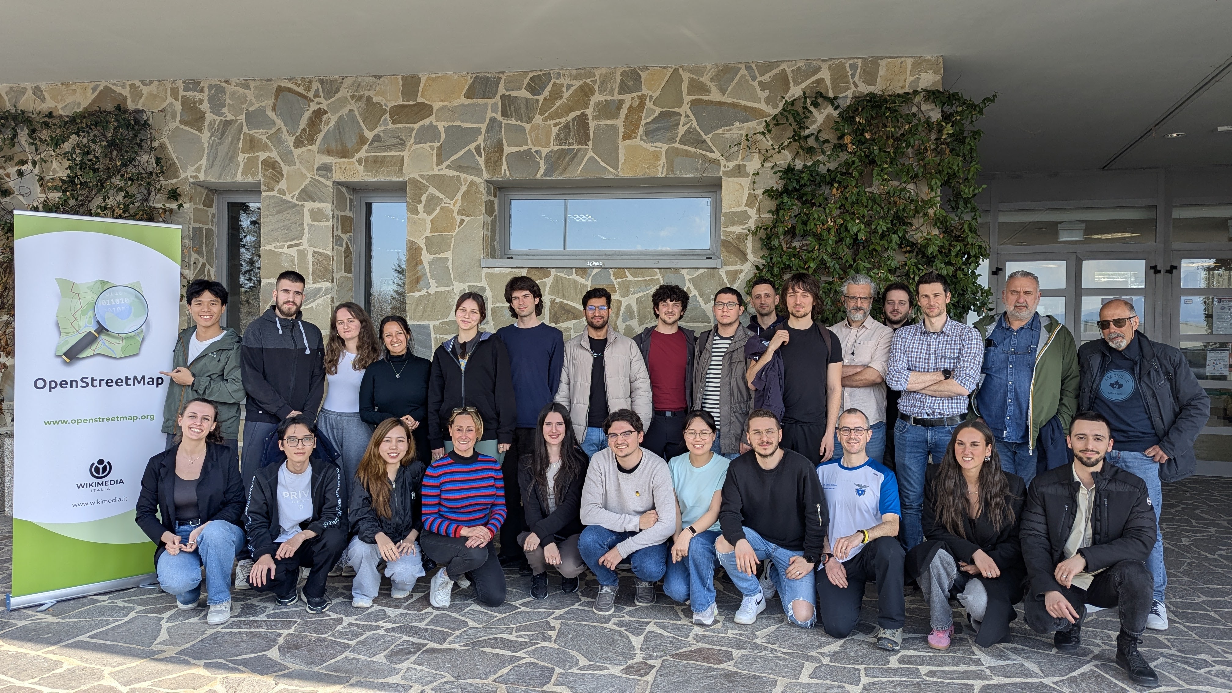
On Thursday, the 10th of April 2025, we celebrated the event “OpenStreetMap: Mapping & Hiking” at the University of Camerino, Italy. After two months of preparation, the event was well-received and had a diverse and satisfied crowd.

Group photo

OpenStreetMap (OSM) is a collaborative geographical database of the world. Millions of people use its data, and also millions contribute to it in various ways. However, there are still places where there is no strong local community, where its villages and rural areas are heavily undermapped. Camerino, while the town itself is well mapped, has some incredible nature and cultural spots nearby, which needed an update. As well, being a university town with students coming from all corners of Italy and the world, makes it a prime location for engaging in outreach activities and kickstarting a community.

See full entry

Location: San Paolo, Camerino, Macerata, Marche, 62032, Italy

How complete are addresses in OpenStreetMap in Belgium? After several status these previous years (see September 2022, in May 2023, and in May 2024, November 24), I finally adapt the process to analyse addresses completeness for all Belgium!

The aim of this small article is to assess the completeness of addresses in Belgium for OSM, compared to official data. Basically we count the address points in OSM and in official data by municipalities. We don’t check the address quality here, we know there can be errors in OSM data, and even in official data.

How I proceeded

Using QGIS, I gathered OSM addresses and official ones. OSM data is imported in a PostgreSQL database using osm2pgsql based on a pbf file for Belgium from the 24th of April. Official data is coming from BEST address csv files, that gathers Belgian addresses for the 3 regions of the country.

Addresses in OSM can be mapped on buildings (most of the cases), hence on a way, or on a node. I consider only objects with the “addr:housenumber” tag. First, I made a single layer of addresses points from OSM data by merging the centroids of buildings with this tag and the points with these tags, by excluding the places where these two layers overlaps (typically points with an address inside a building where there is already an address). The method is far from perfect: I don’t consider relations, I miss some way objects with addresses but without the building tag (typically some schools), and probably a lot of other edge cases due to the “joyeux bordel” of the OSM data model.

Official data considers several address points for each building unit, or box number. It means that there are often several points at the same place, especially in cities, accounting for each box number. Since the mapping of box number is often not so used in OSM, I merged all points at the same place (given a buffer of 1 meter) as a first step. This reduces the number of official address from 7,004,321 to 4,454,017.

See full entry

Location: Pentagon, Brussels, Brussels-Capital, Belgium

EN version below

Ce post a été initialement publié ici.

Le 14 décembre 2024, Mayotte était frappée par le cyclone Chido, le plus violent qu’elle ait connu depuis plus de 50 ans. Rapidement, l’IGN a diffusé des imageries Pléiades prises les 17, 18, 20, 21 et 24 décembre et a confirmé le 25 décembre que la communauté OSM pouvaient les utiliser comme source dans ses éditions. De suite, j’ai eu l’envie de les utiliser pour évaluer les dommages du bâti. Pourquoi le bâti ? Du point de vue cartographique, parce que les dommages sont plus visibles sur des infrastructures polygonales que ponctuelles ou linéaires. Du point de vue de la réponse de crise, parce que les dégâts étaient particulièrement importants, ayant fait disparaître ou rendu impraticables les foyers de beaucoup d’habitants.

Trois mois après, ce billet revient sur les grandes étapes de cette cartographie toujours en cours, organisée bénévolement sur du temps libre.

Revue et choix méthodologique

La cartographie des dommages du bâti à l’aide d’imagerie post-désastre n’a évidemment pas été inventée dans OpenStreetMap et des expériences similaires ont déjà été menées par le passé dans OSM.

Après le passage du cyclone Haiyan sur les Philippines en novembre 2013, une cartographie des dommages du bâti avait été réalisée sur la région autour de Tacloban. Par ailleurs, des chercheurs du Harvard Humanitarian Initiative (HHI) avaient publié en mars 2016 un article détaillant une méthodologie qui avait été de suite adaptée à OSM sous la forme de modèles de préréglages et d’un style cartographique pour JOSM, et appliqués notamment à Haïti après le passage du cyclone Mathieu en octobre 2016.

See full entry

Location: Combani, Tsingoni, Mayotte, 97680, France

OpenStreetMap Indonesia, in partnership with TomTom, organised a Community Mapping Party at GoWork Plaza Indonesia in Jakarta on Saturday, 26 April 2025.


Planning

January 23, 2025 – 17:05 WIB

“For those living in the Jabotabek area, how about we hold our first offline monthly talk next time and align it with the TomTom Mapping Party event?”

Initial discussions about hosting an offline gathering began among members in the Greater Jakarta area. A suggestion was made to align the monthly community meeting (usually held online, but in this proposal, it will be held offline for the first time) with an upcoming Mapping Party event organized by TomTom. The idea was presented in an open-ended way, inviting members to consider the possibility when time allowed.

January 30, 2025 – 08:34 WIB

“It might be better to hold it before Ramadan.”

The conversation picked up pace, with another participant suggesting that it would be preferable to hold the event before the fasting month (Ramadan) began. The comment hinted at the logistical advantages of scheduling it earlier.

February 3, 2025 – 11:01 WIB

“If it is held before Ramadan, preparation time would be very tight. It has been proposed to schedule it after Eid, possibly in mid or late April, and a response is still awaited.”

It was mentioned that holding the event before Ramadan might be too rushed given the short preparation time. As a result, a new proposal was introduced: to hold the Mapping Party after the Eid al-Fitr holiday, possibly in mid to late April. Final confirmation was still pending at that point.

March 23, 2025 – 14:28 WIB

“If we hold an offline mapping party and meetup at the end of April 2025 somewhere around Jabodetabek, would participants be able to attend?”

See full entry

Posted by Ed48152 on 26 April 2025 in English.

I have added a pin for my house, which is at 38150 N Vista Dr in Livonia! From here, I have encountered tons of wildlife, including fish, and generally been treated pretty well. There are parks nearby, riparian zones, old-growth forests, modern civilization including a hotel with swimming pool, and plenty of transportation opportunities. You can even walk here. There’s water, a lawn, and interesting people here. My basement is the coolest!

Location: 42.436, -83.424
Posted by Jaiden1254 on 26 April 2025 in English.

This blog post is part of a series of blog posts about the new OSM file format “OMA”. This is the last post. At the end of the article you’ll find links to the other blog entries.


I will end this series of blog posts about the OMA file format with a short summary of all the feedback I have received and a brief outlook. But first I’d like to give you a real-life example that uses OMA files.


A Real-Life Example

Over a year ago I wrote a renderer suitable for displaying micromapped areas. I used it to generate tiles at zoom level 20 for the restricted area of my micromapping project.

Now I have adapted this program to use OMA files and recomputed the tiles for the area of my micromapping project. The program can be found on GitHub; and there’s a slippy map showing the tiles.

For example, this is what the station forecourt of Hilden looks like:

station forecourt of Hilden


Summary

See full entry

Hello, I have completed work for the first part of the project. Central Wilson and the length of Fish Creek road have reached a point where roads, driveways, structures, and water features have been thoroughly digitized. Check it out and let me know what you think! :) I am sure there are some things I’ve overlooked and maybe some mistakes in these areas. However, given that they are seeing a fair amount of development, I will likely be returning to them soon to update and double check for possible mistakes. I do have a question for you all out there, more experienced than me. I have come to despise the existing residential-landuse areas in Wilson. They are a mess and seem to be quite outdated. I would be more than willing to fix or make new ones, but I don’t know if there is a specific way to go about that kind of thing. Do they need to be based on any administrative boundaries or are they a more arbitrary area? As for what’s next in the project, I am moving east to the Stilson area to fill in completely missing neighborhoods, improve roads, add water features, etc. I will give the next update once completed.

Location: 43.518, -110.839