Diary Entries in English

Recent diary entries

Posted by Graeme Herbert on 29 November 2024 in English. Last updated on 18 December 2024.

Manaus To Santarém

Another early morning start as we walked down to the port at dawn to catch the Santarém boat. This time there was none of the queuing and complication that we had in Tabatinga - we showed our ticket and went straight on to the boat.

The early bird catches the best hammock position, and the first impressions of the Madame Crys were positive. It seemed to be a more modern boat than for Tabatinga to Manaus. It didn’t fill up completely but was busy and we did the right thing getting there early.

As we left Manaus It was clear that this was a more powerful, but less noisy, boat. We were up front looking for the meeting of the waters as the appropriately named Río Negro joins the Amazon a short distance out from Manaus For kilometres the two rivers run with little mixing and very different colours, and our boat steered very close to the visible dividing line.

Manaus a Santarém 09

See full entry

Location: Augusto Montenegro, Urucurituba, Região Geográfica Intermediária de Parintins, Amazonas, North Region, Brazil
Posted by SColchester on 28 November 2024 in English. Last updated on 1 December 2024.

Debrief conducted by Sam Colchester (HOT) partner engagement lead for this activation.

Relevant statistics

In total 171 contributors made over 125,000 edits to OSM including mapping over 96,000 buildings as part of this campaign. (See ohsomeNow Stats page for tracking overall contributions)

Nigeria Floods 2024 Stats
Nigeria Floods 2024 daily contributors

Narrative summary

Shortly after the severe flood event in Nigeria on Tuesday 10 September 2024 the director of the Open Mapping Hub - West and Northern Africa requested support from HOT’s central team to respond.

See full entry

Posted by Graeme Herbert on 27 November 2024 in English. Last updated on 18 December 2024.

Manaus

I had very mixed feelings about returning to Manaus, 36 years after my first failed attempt at an Amazon boat ride to Belém. I hadn”t expected ever to return, had it not been for the FOSS4G announcement of Belém as the 2024 location. I hadn’t liked the city much the first time, although this had a lot to do with the local climate. Maybe I’m a bit more used to this now, after living so many years in Spain, but Manaus still felt like the hottest place I had been on the journey.

Manaus 04

We got a new member of the team here, my partner Silvia flew in from Madrid just a few hours after the Tabatinga boat had docked. When she booked her flight back in August we had very little idea of when I was going to arrive in Manaus, in the end it worked out very well.

See full entry

Location: Nossa Senhora Perpetuo Socorro, Iranduba, Região Geográfica Imediata de Manaus, Região Geográfica Intermediária de Manaus, Amazonas, North Region, Brazil
Posted by tyr_asd on 27 November 2024 in English.

My Talk at State of the Map 2024

(How the iD Editor still can to do better in the long term)

This September, I presented some ideas for the future of OSM’s iD editor at the State of the Map conference in Nairobi. Now, the video recording of the talk is online. To summarize the talk’s content: I identified two core challenges faced by the iD editor which need to be addressed in the upcoming years:

1. Data Complexity

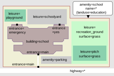
Naturally, OSM’s data got more complex over time – as an example, a simple school might have typically been mapped as a single POI node in OSM a couple of years ago, while nowadays the state of the art is to model it using multiple map features that are nested within each other. While this allows to represent the reality in a high level of detail, the added complexity needs to be accommodated for by the tooling, especially in an editor tailored for beginner mappers like iD. For a deep dive into this topic, see also Sarah Hoffmann’s talk at the same conference.

schematic mapping of a "school" consisting of different features representing objects like the school ground, school building, playgrounds, access paths, entrances, etc.

See full entry

Posted by Graeme Herbert on 26 November 2024 in English. Last updated on 18 December 2024.

Tabatinga To Manaus 3

By day 3 on the Manaus boat I was beginning to doubt that we might get there the next day. It seemed the boat was moving too slowly, we were tracking the route and there was a lot of river still before Manaus.

Tabatinga a Manaus 21

What we didn’t know is that the boat stops less on the second half of the journey, I guess because many of the places further downstream have their own services to Manaus. It did stop briefly in the river a couple of times just to let people off onto a smaller boat that was waiting.

The main event of the third day was a fairly thorough police check of the boat. I was fast asleep in my hammock when It happened, men had to line up on one side of the deck, women on the other. All baggage was also lined up in the middle so they could pass the sniffer dog by everything. We were stopped about an hour for this, it’s quite a routine thing on public transport here, I was told.

See full entry

Location: -3.132, -59.996
Posted by Graeme Herbert on 25 November 2024 in English. Last updated on 18 December 2024.

Tabatinga To Manaus 2

Sleeping solidly is not that simple, the boat can stop at any time of night, and it turns out the range of comfortable sleeping positions in a hammock is not that big. But it doesn’t matter, the only schedule on board revolves around meal times, there’s nothing else to prevent anyone from resting when they feel like it. It can also be surprisingly cold on the open boat at night. I came prepared with a thin blanket and it’s not unusual to feel the need for a cover during the night. The first night there was also a distraction, a spectacular lightning display in the distance.

Day 2 started with our early breakfast, a ham roll and a cup of ridiculously sweet coffee. If there is one thing I really dislike in Brazil it is this custom where the people who make the coffee decide how much sugar the person who drinks the coffee is going to want. It’s always a lot, obviously there is a major sugar cane surplus. I managed to get some progress done on my diary entries and then it was river watching as a big rain storm moved in whilst the boat was ar one of the stops. In 20 minutes water was pouring down all the slopes towards the port. A small creek under a wooden bridge transformed into a torrent. All water still welcome in tbe Amazon, looking at the banks of the river I reckon there is room in the river for 8-10 metres more of water.

See full entry

Location: Juruá, Região Geográfica Imediata de Tefé, Região Geográfica Intermediária de Tefé, Amazonas, North Region, Brazil
Posted by Pieter Vander Vennet on 25 November 2024 in English. Last updated on 2 December 2024.

In the past weekend, I did (two) walks in Ghent where we used https://mapcomplete.org/surveillance to spot surveillance cameras. The press was interested as well, resulting in some interviews and articles!

Those are in Dutch of course.

The local TV did a decent job: https://avs.be/nieuws/openstreetmap-vrijwilligers-brengen-cameras-in-gent-in-kaart

The newspaper article: https://www.hln.be/gent/vrijwilligers-trekken-door-gentse-straten-om-alle-cameras-in-kaart-te-brengen-een-half-miljoen-hangen-er-in-dit-land-maar-niemand-weet-exact-waar~a8b9341c/ which isn’t to bad as well (paywalled, without paywall: https://archive.ph/4GUZQ)

And on VTM: https://www.vtmgo.be/vtmgo/afspelen/e9e73a3b-b932-400a-91b9-af78622cbbaf (starting at 20:30, account required; I wasn’t able to rip it)

Edit 2024-12-02: the local municipalities also wrote about it: https://www.wvigisco.be/tips-en-tricks/open-data/openstreetmap/vrijwilligers-inventariseren-bewakingscameras-met-mapcomplete/

(If you don’t want to create an account, you can also find them on my NAS)

Location: Muinkparkwijk, Ghent, Gent, East Flanders, Flanders, 9000, Belgium

A new week, a new OpenStreetMap-NG development update. This week, we announce the release of two significant features: an overhaul of the User Diaries and the implementation of client-side password hashing.

🔖 You can read other development diaries here:
osm.org/user/NorthCrab/diary/

⭐ This project is open-source — join us today:
https://github.com/openstreetmap-ng/openstreetmap-ng

GitHub Stars

🛈 This initiative is not affiliated with the OpenStreetMap Foundation.


Video Summary

Join me for a guided tour of the new functionalities. In this week’s video, I compare OpenStreetMap-NG’s approach with the current implementation, highlighting key improvements in navigation, performance, and user experience.

⬇ Click the image below to play

See full entry

Posted by Graeme Herbert on 24 November 2024 in English. Last updated on 18 December 2024.

The Second Boat -Tabatinga To Manaus

Departure day from Tabatinga and the start of the real adventure. Be here at 8, they told us when we bought the tickets, so here we were not much after that time, but once the people waiting for the fast boat had left there was just a handful of us. I didn’t mind, the early arrivals get the best hammock space and 4 days is a long time to spend in the wrong spot.

Tabatinga 02

See full entry

Location: -3.408, -68.508
Posted by Graeme Herbert on 24 November 2024 in English. Last updated on 18 December 2024.

The Triple Frontier 3

Monday was a list of things to do, the last day before departure for Manaus. Priority number one was to move from a hostel too far away from the crossing into Tabatinga to one that was almost on the frontier, a pillar 10 metres away from our rooms marked the boundary. A brief stop for breakfast and down to Tabatinga port to buy our boat tickets, again checking out hammocks on the way.

Tabatinga 01

See full entry

Location: Colombia, Leticia, Amazonas, RAP Amazonía, 910001, Colombia
Posted by Graeme Herbert on 24 November 2024 in English. Last updated on 18 December 2024.

The Triple Frontier 2

Day two in Leticia began with another visit to Tabatinga. It was Sunday and the boat ticket office wasn’t going to be open, but we did need to get our Brazilian entry stamp in our passports, we weren’t going to get on the next boat without that. Remote land borders can often be more difficult to cross than arriving at international airports, but we had no problems here - a couple of questions about the purpose of our visit and it was done.

With the rest of the day free we went back to Leticia and got on a boat to Santa Rosa for the last time on Peruvian territory on this journey. Johnattan was carrying a small drone, and we wanted to do a bit of drone and street level mapping of the island. All of the main points of interest on Santa Rosa are concentrated on a single road, so we mapped our way up from the clutch of restaurants facing Leticia to a midpoint in the village and decided that the heat merited a refreshment stop in a friendly and spacious bar restaurant.

See full entry

Location: -4.226, -69.958
Posted by Graeme Herbert on 24 November 2024 in English. Last updated on 18 December 2024.

The Triple Frontier

With an eye on our (OSM powered) maps the first surprise on arrival at Santa Rosa was that we were being dropped off on what appeared on the map to be a separate island. Our moto taxi driver explained the reason for this, the drought that had affected so much of Amazonia had also changed the endpoint for a ferry that had been unable to run a few weeks before our arrival. In reality the two islands shown on the map are currently one, with a dip on the muddy track being the only indicator.

The triple frontier is a curious place, there are no formal border control posts, you have to go on arrival from Iquitos to the immigration office in Santa Rosa to get the Peruvian exit stamp, a pre-condition for subsequently getting entry into Colombia or Brazil. We were almost the first ones there at the office and the exit process took about 5 minutes. Then it was down to the boats that take you across to Leticia (in Colombia) or neighbouring Tabatinga (in Brazil). It’s a short crossing, I had read a couple of months earlier that in the worst moments of the drought people were able to cross on foot. That’s no longer the case, but the creek taking us in to Leticia had barely enough water to permit incoming and outgoing boats to get past each other.

See full entry

Location: Centro, Leticia, Amazonas, RAP Amazonía, 910001, Colombia
Posted by Graeme Herbert on 24 November 2024 in English. Last updated on 18 December 2024.

The First Boat - Iquitos To The Triple Frontier

The boat from Iquitos was to be our sole concession to relative comfort on the river, foreigners have to pay a higher price for the ferry than locals, but the benefit was to be on the upper deck with more space, and an outside area at the back. There are faster boats doing this stretch of the river, but you are stuck inside the boat the whole time with very limited views of the river. Ours was the middle option between the three day slow boat and the fast service, and finally we were on our way down the Amazon.

Iquitos Peru 23

Leaving in mid-afternoon we had about 3 hours of daylight left for river watching. The first proper sunset I had seen in Peru lit up the river before dark. And then we had a glorious full moon ahead of the boat, meaning that we had some visibility all night long. The ferry is quite modern and relatively fast, we even had a TV showing Peru playing Chile in a World Cup qualifier.

See full entry

Location: San Pablo, Province of Mariscal Ramón Castilla, Loreto, Peru
Posted by Graeme Herbert on 24 November 2024 in English. Last updated on 18 December 2024.

Iquitos

One more plane, and then the real Amazon journey begins. I think I read somewhere that Iquitos is the largest city in the world that has no road connection to other parts of the country It belongs to. So a plane was the only alternative to seven days on the Rio Ucayali.The plan was to get to Iquitos and leave as soon as we could get a boat, with roughly two weeks left before arrival in Belem at the beginning of December for FOSS4G. and SOTM LATAM. In the end it was to be an overnight stay, there was a ferry leaving the next day for the Triple Frontier shared by Peru, Colombia and Brazil.

Iquitos Peru 02

See full entry

Location: Progreso, Belén, Province of Maynas, Loreto, 16001, Peru

TL;DR

Bing imagery in Greater Accra Region is very very old but it continues to be used as the primary reference for adding new data into OpenStreetMap. Esri World Imagery however seems more recent in and better aligned thank Bing.

This diary is a comparison of seleted locations in Accra with new developments that can be clearly seen in Esri World Imagery but not in Bing; one of the reasons not to use Bing as primary reference for adding new data into OpenStreetMap in Accra.

Bing imagery also have some interesting imagery offsets and mosaic problems such as the photo below and around this node. Bing vs Esri in Accra, Ghana south of Kotoka Internation Airport

Location on OSM

©Bing aerial imagery (left) and ©Esri World Imagery (right).

See full entry

Location: Tudu, Accra, Korle-Klottey Municipal District, Greater Accra Region, Ghana
Posted by Graeme Herbert on 22 November 2024 in English. Last updated on 18 December 2024.

Pucallpa

Iquitos wasn’t our first Amazonian destination, before we headed for Pucallpa - located on the Ucayali river much further south. Johnattan has worked there and is also heavily involved in the local OSM group. At one point we even considered starting the Belem boat trip in Pucallpa, the Ucayali combines with the Marañon river way down nearer to Iquitos to form the Peruvian Amazon. But an estimated seven additional days on a boat to Iquitos was a bit too much, another time maybe. I was dealing with the change of atmosphere from the western side of the Andes, it poured with rain shortly after arrival and moving around in tuk tuk style transport to get anywhere made it feel like a different country.

Ucayali inicio del viaje FOSS4G SotMLatam 2024

See full entry

Location: Carlos Tubino, San Fernando, Manantay, Province of Coronel Portillo, Ucayali, 25002, Peru

Huaraz

We were in Huaraz for an event on climate justice organised by the South American Wikimedia community. A very interesting event, my first with Wikimedia, and with a particular emphasis on giving a voice to the representatives of indigenous communities. Including a forum involving Saul Luciano who took the German energy giant RWE to court in a landmark case for their contribution to emissions that help to melt the glaciers that in turn threatens a deadly lagoon overflow for those living in the flood path below. He said he had never seen the glaciers recede as much as they had this year. OSM got some time and mentions at the event, although it got me thinking about how communities with so much in common seem to live separate existences.

And we did some mapping, enough to refresh data for the centre of Huaraz. My first Peruvian changesets. As for the nearby mountains, I had taken a tough packing decision to fill valuable rucksack space with my mountain boots and a bit of winter clothing in case I had the chance for a day in the mountains. it didn’t happen, the weather wasn’t kind and the boots haven’t seen any use. Of course the views of snowy peaks had to be fantastic the next day as we flew back to Lima in preparation for moving onwards to Amazonia. A planned presentation/workshop in a Lima university never happened as a strike timed to coincide with the APEC international summit closed the university for three days.

Location: -9.530, -77.525

Landing In Lima

There were nervous moments before starting the journey. The terrible drought this year across Amazonia even put the whole project in doubt, we couldn’t be sure that the boats would be running as reports came in of Amazonian towns suffering water shortages. Together with the brutal wildfire season it seemed that we had picked the wrong year, although the real question after 2 consecutive years of drought might be whether there will be better years to come? Hard to believe when I looked at the hydrological data I had loaded for the Amazon basin. At one point I was considering buying a reserve air ticket from Lima to Manaus, which would have been a very disappointing way to do that journey. In the end October brought better news, it rained enough for the boats to run and Johnattan organised a short Peruvian itinerary (including OSM mapping!) which would take us to Iquitos for the first boat down the river. The first of three or four that we would need to get all the way to Belem with an estimated travel time of two weeks.

I landed in Lima on the 5th November and had a couple of days to acclimatise before setting off for the first destination on the trip. Great ceviche in a market stall which the tourist guidebooks will hopefully never discover, and time to see some of the city. Even time to drink a bit too much pisco, but you have to try the local products? Then it was off to Huaraz, located at 3000 metres and lying below the Andean peaks of the Cordillera Blanca. What does this have to do with Amazonia? The mountain chain is where all the debate about the source of the Amazon is focused. You can hardly get more of a landscape contrast than that between the western and eastern sides of the Peruvian Andes. I went up to Huaraz on the bus, and through the desert surrounding Lima then upwards through a semi arid mountainous landscape which differs sharply from the forest to be found on the eastern slopes.

Location: Lince, Province of Lima, Lima Metropolitan Area, Lima, 15046, Peru