Diary Entries in English

Recent diary entries

Posted by hobbesvsboyle on 8 June 2024 in English. Last updated on 17 June 2024.

I love to ride my bike. Long distances. New roads. Usually starting from my home in Madison, WI. I also love mapping. And so whenever I’m out riding I try to do at least a bit of OpenStreetMap data collection. When I see interesting features, like a bike repair stand, or stop at a potential point-of-interest, like a café or gas station, I take a picture on my phone and add the data to OSM once I’m home.

Wandrer.earth map of roads I have bike in around Madison, Wisconsin. I have ridden a lot of them.

Recently I became interested in improving the quality of surface tags for highways. Dane County is known to have a very high proportion of paved roads. Even small rural farm roads are almost always paved. But pavement data in OpenStreetMap is spotty. Therefore I was interested in developing a workflow that allows me to add/update surface=* tags through my bike rides.

I asked for advice on this on the OSMUS Slack channel and got some good suggestions. Based on these suggestions, I developed the following workflow.

During the ride

See full entry

Location: Mifflin West, Downtown, Madison, Dane County, Wisconsin, United States

Hi, dear reader.

This is over a week-due post. I posted it on my blog on Dev.to and decided to share it here. Enjoy.

………………………………………………………………………………………………………………………………………………

The people I admire the most used to be healthcare professionals, like my eye doctor. Once, I spent a good time telling him how he was improving lives. I mean he helped me see better. That was noble to me.

Now you know my new set of favourite people? They are the ones who have chosen to dedicate their time to improving people’s lives with open software. They come in different forms: open-source contributor/volunteer, maintainer, committer (I just learnt of this, courtesy of Open Source Guide). These people come together with the shared goal to build and improve software whose source code is available to everyone. As opposed to private proprietary software.

It is with joy that I share that I will get my first experience contributing to open-source for the next 3 months. Through the Outreachy internship, I was selected to work with HOTOSM from May to August 2024.

Outreachy is a paid internship that supports underrepresented individuals in tech to contribute to open-source projects. And HOTOSM(Humanitarian OpenStreet Map), the organisation I will be working with uses open mapping for humanitarian purposes, providing map data to aid in disaster management, community development and the achievement of Sustainable Development Goals.

I have had a great first week with HOTOSM. I have received warm welcomes from my mentors, fellow intern and our coordinator.

See full entry

Posted by IrdiIs on 8 June 2024 in English.

Qerret (18/40.56564/20.40550) was pretty well mapped but while searching for Qerret, many villages with the same name came up, so i decided to map a couple of them.

  • Qerret (Kavaje) 18/41.21660/19.52769, mapped most of it.

  • Qerret (Gramsh) 18/40.90477/20.16848, mapped most of it.

  • Qerret (Elbasan) 18/41.21761/20.19745, added some buildings.

I just realized that instead of adding the tag “#100villagesin100days” under Hashtags i have been adding under Sources… I do not know if there is any way to correct the mistake.

“#100villagesin100days #day8”

There is a growing trend for youth in India to use smartphones throughout universities and colleges alike. At this moment, I saw a potential chance as an OSM enthusiast to introduce a smartphone OSM app called Map Swipe. I had the pleasure of visiting St Anne’s College to discuss the mission of mapping for a community and a good cause. During my visit, I introduced MCA students to the amazing software Map Swipe. This app is a double-edged sword, but when utilized for a good purpose, it may have a big influence. The initiative focused on mapping earthquakes in Papua New Guinea and healthcare in Champai, India.

I am grateful to the Open Mapping Hub - Asia Pacific and GRED Institute of Geoinformatics for their contributions to this research. Their assistance has been crucial in making this endeavour a success.

Mapping has the potential to be a strong instrument for positive change, and I’m excited to see how it continues to improve communities.

OSM Guru St Ann's Field Visit

Location: 17.394, 78.437
Posted by nicyK20 on 7 June 2024 in English.

My name is NISENGWE Claudette and I go by nicyK20 in open street map. I joined OSM in March, it was in in ,mapathon organized by OSM Rwanda community to celebrate International women day. I saw a link in a WhatsApp group, I applied and they selected me. At time I didn’t know what mapping was, but they explained to us what they do and I became interested. I took their contact, they gave me more information. OSM Rwanda community is a very good community and I like how they make me feel included. much respect to its founder Rebecca and all mentors.

Location: Kabacuzi, Muhanga District, Southern Province, Rwanda

I found out Faqekuq is one of tens of villages surrounding my hometown, so I got excited. Faqekuq is a tiny village with a very small population and just a bunch of houses, so I proceeded mapping also the closest villages, Kapinovë and Turbohovë.

Kapinovë is a beautiful village and I have visited it many years ago when I was a teenager. I am so happy I got to add it to the map. To me, it is very important having this small, almost fully abandoned villages on the map because they should not be forgotten.

Movie suggestion: Bacurau

Sorry for the spoiler!!

One thing that hit me the most from this movie is that the government deleted the place for the map to make it disappear.

“#100VillagesIn100Days #Day7”

Introduction

My name is Lelio de Jesus Alves, and I am from Timor-Leste. I have been using OSM since 2022 and am currently participating in the OMGuru Fellowship 2024. I am excited to share my journey into open-mapping, what I find fascinating about the fellowship, my experiences, the lessons I have learned, and the impact it has had on me.

How I got involved with Open-Mapping

My journey into open-mapping began during my fourth year of university when I stumbled upon OpenStreetMap (OSM). Fascinated by the intersection of technology and geography, I joined an OSM workshop. The idea of contributing to a global, freely accessible map captivated me. I started by mapping my hometown, identifying missing roads, buildings, and other key features. This initial involvement opened doors to various mapping projects and eventually led me to apply for the Guru Fellowship.

Interesting/Fascinating about being the Guru Fellowship

What fascinates me most about the OMGuru Fellowship is the opportunity to connect with like-minded individuals who are equally passionate about mapping and geospatial technology. The fellowship is a unique platform that not only enhances my mapping skills but also connects me with a network of dedicated mappers and developers from around the world. One of the most fascinating aspects is the collaborative nature of the community. Despite geographical distances, we work together to improve the quality and coverage of OSM data. Ensuring data quality in OSM is particularly gratifying, as it enhances the map’s usability and builds user trust. This global collaboration embodies the spirit of open-source and community-driven projects, making it a truly enriching experience. By validating and improving data accuracy, I feel I am making a significant contribution to the global mapping community and supporting projects that rely on precise and dependable geographic information.

Define My experience as a Guru

See full entry

Location: Kampungbaru, Dom Aleixo, Dili, East Timor

OM Guru Journey

One of the best choices I’ve made in recent years was joining the Open Mapping Guru program initiated by the HOT Open Mapping Hub Asia Pacific. In 2024, I joined the validation track team. The challenges and tasks given each month are very interesting and help us, as OM Gurus, to make an impact on the community. So far, more than 300 tasks have been validated. However, that’s not all.

My Favorite Challenge

The OM Guru Climate Change Challenge is the peak of this year’s challenges, I must say. At first, I didn’t really pay much attention to the challenge since I saw many great teams out there ready for all the challenges. Until I saw a sub-challenge called the POI’s Mapping challenge. The best part is that for this challenge, I was only asked to map Points of Interest (POIs) in my area using local knowledge. Coincidentally, the area where I live, Bogor City and its surroundings, needed a significant data update. With my relatively high mobility in this area, I really used my local knowledge because I have almost passed through every corner of the city and some main roads I pass almost every week.

Surveying, Skating, Hanging Out

See full entry

Location: Ciwaringin, Bogor Tengah, Bogor, West Java, Java, 16124, Indonesia

Today I mapped the village of Gjerë. According to OSM data, the village has a population of around 400. The houses are scattered around the huge territory and around farmlands. I also expanded a little and mapped the surrounding areas.

“#100VillagesIn100Days #Day6”

Location: Gjerë, Poroçan, Bashkia Gramsh, Elbasan County, Central Albania, 3308, Albania

The Generous Open Mapping-Data Quality Focused

Open mapping is a powerful tool for creating and sharing geographic data in a collaborative and open manner. Its benefits include increased data accuracy, improved data integration, and enhanced data visualization capabilities. However, it also has some limitations that need to be considered, such as data quality and security concerns. Open mapping has been instrumental in various initiatives, such as humanitarian aid, disaster response, and urban planning, and has become a vital resource for many organizations and individuals. While open mapping has many benefits, there are also some limitations to consider:

  1. Data Quality: Open mapping data may not always be accurate or up-to-date, as it relies on contributions from a community of volunteers.
  2. Data Integration: Open mapping data may not always be easily integrated with other data sources, as it may use different formats or standards.
  3. Data Security: Open mapping data may be vulnerable to security risks, as it is publicly available and can be accessed by anyone. Data quality is a critical aspect of open mapping initiatives. By understanding the challenges and implementing best practices, open mapping communities can improve data quality and ensure the accuracy and reliability of the data.

See full entry

This diary entry is also available as a personal page on the OSM wiki.

Some History of GNIS Imports

GNIS is a database developed by USGS that contains information about the official, standardized names for geographic features in the US.

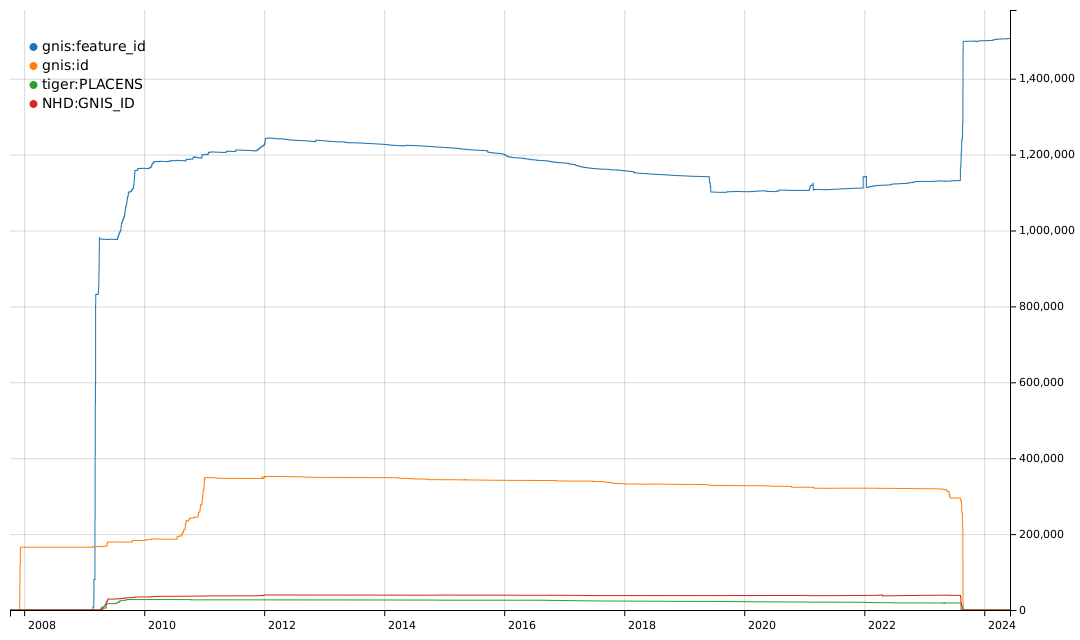
From 2008 to 2011, there was an effort to import basic data into the US map, including records from GNIS and records from TIGER and NHD that are cross-referenced to GNIS. You can see some of the history of these imports based on the tags they used.

Graph of the history of tags for GNIS Feature IDs

The gnis:feature_id tag was typically used for imports of many types of GNIS records. The gnis:id tag was used for imports of nodes for Populated Places, i.e. place=city, town, village, hamlet, etc. The tiger:PLACENS tag was used for imports of civil boundaries from the US Census Bureau datasets and contained a GNIS Feature ID value. The NHD:GNIS_ID tag was used for imports of waterways and other hydrographic features from the National Hydrography Dataset and also contained a GNIS Feature ID value.

See full entry

Posted by martin-kokos on 5 June 2024 in English.

OpenStreetMap is the project that picks where products that are driven by commercial incetives end. One of those areas is mapping the world also with respect to accessibility for people with disabilities. I’d like to talk about OSM for the blind (4).

Full text I’ve posted for the purpose of discussion to:
https://community.openstreetmap.org/t/more-osm-for-visually-impaired/114200

🌟 Calling all designers and creatives! 🎨✨

We’re on the hunt for the perfect logo for #SotMAsia24! 🌏✏️ If you’ve got a knack for design, we want YOU to paint the face of this year’s State of the Map Asia event in Cox’s Bazar, Bangladesh. 🇧🇩🗺️

Check out the details and submit your masterpiece by June 15th, 2024!

Check out the details here: osm.wiki/Call_for_Logo

Let’s make this year’s logo shine! 💫

Alt text

Today I mapped Përcëllesh which is a tiny village with a population of around 140. Since the village was very small, I expanded my mapping to the surrounding villages, and i also partially mapped the villages Kryezi and Gurrë.

“#100VillagesIn100Days #Day5”

Location: Përcëllesh, Petrelë, Tirana Municipality, Tirana County, Central Albania, 1034, Albania

I did most editing of the Building and other allied mine infrastructure of this mining site. This Mine site is managed by Harmony Gold Limited of Africa , which I was an employee as a Mine Surveyor .It was the site I worked for 2 months before I left for another job at Simberi Gold Mine in New Ireland Province. I used the Camp maps supplied by National Catering Services(NCS) to populate the Building names in OSM.

Location: Hamata Mining Camp, Bulolo District, Morobe, Momase Region, Papua New Guinea
Posted by IrdiIs on 4 June 2024 in English.

Lapardha e Sipërme seems to just be a point on top of a hill (i will have to figure out if I can get my hands on some data to map the village area correctly.). I figured out the village has some neighborhoods which are located around the hill. I proceeded mapping Muhollarë (Lapardha), Goxhollarë (Lapardha), Gjole (Lapardha), Myrtallarët (Lapardha). This area is filled with greenhouses, but I mapped only some of them. I will try to map the greenhouses another day and focus only on them.

“#100VillagesIn100Days #Day4”

Location: Muhollarë (Lapardha), Lapardha e Sipërme, Otllak, Berat Municipality, Berat County, Southern Albania, 5010, Albania