Diary Entries in English

Recent diary entries

Welcome to the sixth OpenStreetMap NextGen development diary.

This week, I continued the preparation of the project for the first development release scheduled for the end of this month 🔹.

🔖 You can read my other development diaries here:
osm.org/user/NorthCrab/diary/

📖 This project is open-source and publicly available:
https://github.com/Zaczero/openstreetmap-ng

🛈 This independent initiative is not affiliated with the OpenStreetMap Foundation.

In Case You Missed It


OpenStreetMap-NG is planned to have its first development release at the end of this month, May. After this milestone, the project will be open for new contributors! My current work focuses on delivering on that promise, finishing the core functionalities, and stabilizing the code.

Originally posted in diary #5.5.

Finishing Up the Elements Sidebar

The elements sidebar has been mostly finished. The “Part of” and “Members/Nodes” sections are now more consistent in design and have received pagination support. The orange-colored map visualization is also now working.

See full entry

Posted by bhousel on 8 May 2024 in English.

I’m excited to announce that today we released Rapid v2.3 editor for OpenStreetMap! The Rapid team has been busy working on this for the past few months - here’s 4 new features that we hope you’ll love


🔙 Esri Wayback imagery

The world never stops changing! We added a new background layer called “Esri Wayback” to let you view historical releases of the Esri World Imagery. This background source also has a date picker to help you choose from dates likely to show changes in the current map view. Open the Background pane to try it out!

Esri Wayback

🔄 Map Rotation

Take Rapid for a spin! Now you can rotate the map to make your editing easier (and avoid straining your neck!). Rapid supports rotating with option+click-drag or shift+←/→ arrows, just like other maps you’ve used before. A new bearing control displays a north arrow, and you can click it to reset the map back to North-up.

See full entry

collaborative live mapping of regions affected by rain in Rio Grande do Sul - Brazil.

Today we are going to map the area that was affected by the rains in the state of Rio Grande do Sul, there will be a live broadcast at 7:00 pm where everyone can map and help with mapping the affected area.

task link. MAPPING OF ROADS IN THE AREA AFFECTED BY THE FLOOD OF THE PARDO RIVER IN CANDELÁRIA-RS https://tasks.hotosm.org/projects/16696

Youtube: https://www.youtube.com/watch?v=3Wm-nTnCRaQ&t=7s

organization: UFV youthmappers UMBRAOSM

live collaborative mapping in the affected areas of RS

Location: Jardim BotĂąnico, Porto Alegre, RegiĂŁo GeogrĂĄfica IntermediĂĄria de Porto Alegre, Rio Grande do Sul, South Region, Brazil

Greetings!

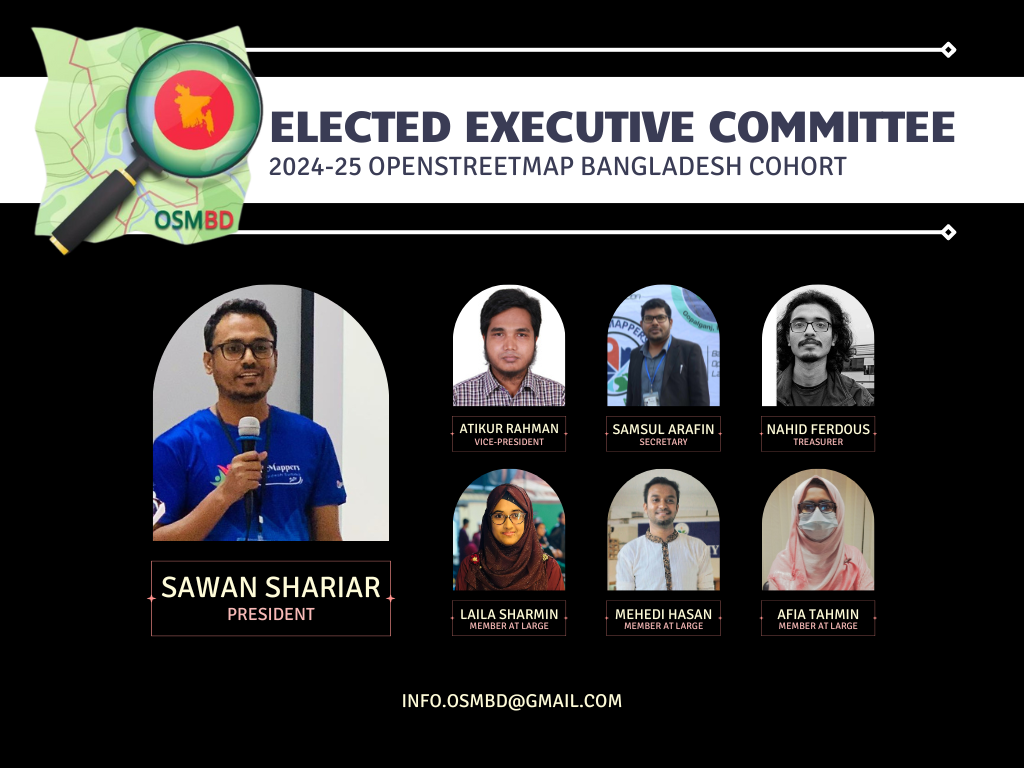
We are thrilled to share some exciting news from OpenStreetMap Bangladesh (OSMBD). For the first time ever, the OSM Bangladesh community has successfully formed an elected Executive Committee, consisting of a team of dedicated individuals who will guide our community’s activities and initiatives.

We are proud to introduce the newly elected Executive Committee:

President: S M Sawan Shariar

Vice-President: Atikur Rahman

Secretary: Samsul Arafin

Treasurer: Nahid Ferdous

Member-at-large: Mehedi Hasan Ovi

Member-at-large: Afia Tahmin Jahin

Member-at-large: Laila Sharmin Nova

Alt text

The committee is committed to upholding OSMBD’s core values of collaboration, community-driven initiatives, openness, and accessibility. Our focus is on promoting the use and development of OpenStreetMap in Bangladesh, building and maintaining a comprehensive map of Bangladesh that is freely accessible, and supporting OSM groups and initiatives through training, events, and more.

See full entry

Location: Monipuri Para, Tejgaon, Dhaka, Dhaka Metropolitan, Dhaka District, Dhaka Division, 1215, Bangladesh
Posted by Enock4seth on 6 May 2024 in English.

Hello OSM World,

Welcome to #WOSMinGhana 000

I am starting a series of OSM Diary posts title Worst of OSM in Ghana, inspired by best and worst of OSM posts I have seen. The idea is to share one photo per week (I hope I can keep up, feel free to share any you might have seen in Ghana too :D). i.e. Before and After (if I am able to improve or fix it)

Sometimes you come across very interesting mapping activities and data and you are out of words. Myself and other volunteer mappers have taken screenshots of worst contributions on OSM in Ghana over the years and then proceeded to improve them / notify mappers or organizations.

Why talk about the worst not the best? Highlighting these worst mappings might help create more awareness about what we put out there as part of individual or organized mapping activities.

This is purposely to help improve OSM data in Ghana in these areas by myself or other mappers and for us all to beware of when mapping.

Looking forward to the coming weeks.

Location: Kwameteng, Sekyere Central District, Ashanti Region, Ghana

Introduction

Humanitarian logistics is defined as the process of planning, implementing and controlling the efficient, cost-effective flow and storage of goods and materials, as well as related information, from the point of origin to the end of consumption to alleviate the suffering of vulnerable people

Its Extent and Impacts

The humanitarian logistics of peace operations in sub-Saharan Africa is one of the most challenging operations in the contemporary world. Faced with this reality, several scenarios challenge conventional logistical practices translated into humanitarian efforts on the African continent. Several events have led Africa to the current situation, whose conflicts have worsened the case in some countries. In this scenario, three countries stand out on the African continent: South Sudan (SS), the Central African Republic (CAR) and the Democratic Republic of Congo (DRC).

1.Positive Impacts

Data Collection and Mapping - GIS technology is used to collect, analyze, and visualize geospatial data. Humanitarian organizations in South Sudan leverage GIS to map various elements such as population distributions, events, infrastructure, health facilities, water sources, and more. This comprehensive mapping enables organizations to identify vulnerable areas and better understand the needs of the population.

Situation and Needs Assessment - OSM aids in conducting rapid situation assessments and needs analyses during crises and emergencies. Each region in South Sudan is prominently represented by one or the other ethnic and communal group, each with its own methods of action. By overlaying various data layers, including demographic, environmental, and public infrastructure, organizations can quickly identify areas that require immediate specialized attention and allocate resources accordingly.

See full entry

Welcome to my fifth (and a half) OpenStreetMap NextGen development diary.
Tomorrow, I’m returning home and I’ll be able to resume work at full speed đŸ”„.

This is a short edition of the development diary.

🐙 This project is open-source and publicly available:
https://github.com/Zaczero/openstreetmap-ng

Intro

For the past 13 days I have been on a journey of finding a new place to rent. Without my home office, I wasn’t able to become productive. The place I’m staying at doesn’t have a good office spot and being on my laptop doesn’t help. However, I am now very motivated to get back to work and push even harder!

May Will Be Big

At the end of May, OpenStreetMap-NG will include necessary functionality to run on a testing server, as well as to invite new contributors into the project. Starting with 6th of May, I won’t have any time-consuming plans for this month so I’ll do my best to wrap everything up. What’s exactly left has been described in Diary #5 Short-Term Development Plan. I have already started to prepare the All-in-One Contributor Guide which will also be finished up (it currently lacks backend/frontend-specific guides). This is going to be the first major milestone of the project!

Project Sponsors 🏅

I was happily surprised to see new faces even during my lower activity period. I will do everything to deliver the promised results. As always, thank you for supporting the project, monetarily, and with staring the project on GitHub!

Currently, the project is sponsored by 13 people!
Five private and four public donors on Liberapay, and four public on GitHub Sponsors.

Disclaimer

This project is not affiliated with the OpenStreetMap Foundation. It’s an independent and community-sponsored initiative.

Posted by ZeLonewolf on 30 April 2024 in English. Last updated on 2 May 2024.

There is a long discussion happening in the United States section of the community forum regarding where to draw the line between the “main” populated place node values, and specifically the place=* values of city and town in New England. I thought it would be useful to do a bit of analysis to see how these values are distributed across the database when compared to population. Through this analysis, I include all tags which have place values of city, town, village, hamlet, and isolated_dwelling. I also only include nodes that have a population tag.

My overpass query for each category looks like this:

[out:csv(::id,place,population;true;"|")][timeout:60];
node[place=city][population];
out;

One of the challenges of analyzing this key is that because it represents order-of-magnitude differences, its distribution is log-normal. In other words, it forms a bell curve provided that the X-axis is drawn logarithmically.

To look at this data logarithmically, I grouped the place nodes logarithmically, in steps of 1, 2, and 5 per 10x jump. When viewing the distribution of place=town, the log-normal shape comes out quite clearly. The number on the X axis represents the upper limit of each bin.

See full entry

Posted by ivanbranco on 28 April 2024 in English.

[Semi-automated translation of the Italian diary entry]

On OpenStreetMap, a tree can be represented as a natural=tree node.

Leaf type 🌿

leaf_type is the most common tree-related tag in the database, this is because it is easily verifiable and is supported with a quest by StreetComplete. The values are broadleaved and needleleaved. Some argue that palms should not be tagged as broadleaved but with a value of their own, =palm.

Leaf cycle 🍂

This tag describes whether a tree is deciduous or evergreen. Most needleleaved tree species are evergreen, but this is not always the case, so do not infer this value automatically. You can add this value easily if you know the species, or more simply if it is autumn/winter. If not, you can try to see if satellite or street-level imagery taken at those times are available.

Genus and species 🌳

If you are not an expert, there are tools that can help you recognise the genus/species of a plant, such as Pl@ntNet and iNaturalist, both of which also exist as mobile apps. On OpenStreetMap there are many trees with species (or species:wikidata or species:xx) that do not have leaf_type or leaf_cycle. These values are of course identical for each species (and also for many genus) and can therefore be easily deduced. There are two lists on the OSM wiki that contain these values for genus and species.

MapComplete has a dedicated tree theme that can be used to enter the species while SCEE has a dedicated quest (“What is the genus or species of this tree?”).

Monumental trees đŸ›ïž

Monumental trees can be mapped adding denotation=natural_monument. In Italy they are recorded by the Ministry of Agriculture, Food Sovereignty and Forests (Masaf) with annual updates. You can map them by adding ref:masaf, which is a unique code assigned by the ministry.

See full entry

Posted by matthewsheffield on 28 April 2024 in English. Last updated on 2 May 2026.

I’ve finished (for a second time!) mapping all the paths in my local cemetery. The first time another mapper decided that concrete or gravel ways designed for walking on weren’t “paths” and deleted them all. He also seemed to have strong feelings about people cycling in cemeteries, which is odd as The Greater Metropolitan Cemeteries Trust actually endorse it as a use of their land. As my daughter is buried in the cemetery I feel some ownership of the place, and do love it and Merlynston creek that flows through it. I’m hoping no one vandalises my work again.

Location: Hadfield, City of Merri-bek, Victoria, 3046, Australia

SotM Latam 2024 - Belém/Parå - Brasil.

The State of the Map Latam 2024 will take place in the city of BelĂ©m, Brazil, from December 6 to 8, 2024 at the Instituto Federal do ParĂĄ, this being the sixth edition of the ‘Latin American OpenStreetMap Conference’ and aiming to promote the use of OpenStreetMap (OSM), and the integration of OSM mappers, developers, open data communities, free and open source software communities, students, researchers, geoinformation professionals, non-governmental organizations, companies and public institutions.

SotM Latam 2024 After the voting period for choosing the SotM Latam 2024 logo has concluded, I am pleased to announce that the chosen option is 1.

See full entry

Location: Marco, Belém, Parå, North Region, Brazil

The eTrex 20x

Years ago when searching for a viewpoint from an old photo where I wanted to do rail photography I managed to locate the exact cliffside overlook and discovered a somewhat hidden gem of trail network in the process.

Though there is an official dirt road in the canyon below and a few desire paths offshooting from it the hills above remained relatively unmapped not showing up in the otherwise void of an area.

With the understatement of the local forecast for the afternoon/evening I packed my beloved eTrex 20x in the camera bag along with my trusty Nikon D700 planning to take in some of the views while there in between tracing runs expecting no more than some cloudiness and a light sprinkling.

See full entry