Diary Entries in English

Recent diary entries

Posted by umbraosmbr on 9 February 2024 in English. Last updated on 11 February 2024.

Mapping and Geoprocessing Course with QGIS (online / 100% Free)

Curso de Mapeamento e Geoprocessamento com QGIS (on-line / 100%

Gratuito)

This is an extension project of the Geography Course at UNESPAR (State University of Paraná), with the purpose of qualifying participants in mapping and geoprocessing using QGIS. This course is certified (up to 60 hours, according to participation) and in this way, we wish to bring knowledge to teachers, researchers, students and the community in general, always in need of new skills to assume their space in the workplace.

CONDITIONS TO TAKE THE COURSE:

  • Have a computer (with good storage and processing capacity) with internet access;

  • Have basic computer knowledge (know how to unzip a folder in Windows, copy and paste procedures, etc.);

  • Be able to attend online classes on Sunday mornings (once a week). Set aside one day a week to watch the theoretical video lessons and practice;

See full entry

Posted by valhikes on 7 February 2024 in English.

Ever since visiting Mount Lassic and then making edits in the region, I’ve had this nagging difficulty: What to do with a mountain whose high point is named differently? Mount Lassic has three peaks, the highest is called Signal Peak. I eventually mapped its survey point, which is also called Mount Lassic, and hoped that was done. (Apparently I shouldn’t map survey points except at the exact point indicated, so I’ve done this WRONG. I’ll just name a peak “Such-and-such Benchmark” then. Except a benchmark is specifically a vertical control and most at peaks are horizontal controls. “Such-and-such Triangulation Station” gets a bit long. Oh, the humanity!) Unfortunately, if one searches for the mountain, one only gets the Mount Lassic Wilderness and the Mount Lassic Trail, but there’s no hint that this goes to the high point of Mount Lassic. It goes, in fact, to “Signal Peak”.

Other places where there’s a named high point (peak) different from the main mountain are Marble Mountain (with Black Marble Mountain the high point). Someone seems to have simply marked a lower peak as Marble Mountain. If one does this, there’s a bit of a debate if it is the highest white peak or the most prominent white peak. Mount Konocti with high point Wright Peak. Currently both are marked close to the high point, but the main mountain has been given a lower elevation so doesn’t show often, but it is searchable.

See full entry

Location: Humboldt County, California, United States
Posted by L'imaginaire on 6 February 2024 in English.

Yesterday, I reached the point of one million map changes and twenty-thousand changesets. Leading up to this milestone, I tracked my progress on How did you contribute to OpenStreetMap? and carefully planned to make a single edit that would be my one millionth in my twenty-thousandth changeset. I eventually made a gimmicky changeset referencing my first mapping experience. Mission accomplished! However, despite the impressive numbers, my initial sense of accomplishment faded, replaced by nagging existential questions. Have the countless hours I devoted to OSM truly been worthwhile? Why have I been doing this? What is it exactly that I have been doing? … What is OpenStreetMap, really? And there it is, a question that seems very simple, but is not. It is the same question that hides far below the surface in Xvtn’s OSM Iceberg Meme. Inspired by this meme, user rtnf put it this way: “Is it a map? A dataset? A community? A trademark that encompasses an entire ecosystem consisting of the dataset, the tagging scheme, the rendering infrastructure, and the subculture around its mappers, developer-mappers, and third-party data consumers?? What is OSM, really?”

When you invite someone to go to openstreetmap.org for the first time, the first thing they read is “OpenStreetMap is a map of the world”. The next thing you usually want to explain to them is that OpenStreetMap is NOT (just) a map of the world. We then continue showing off different rendering styles, different editors, different tagging schemes … We pride ourselves being part of a secret society, where only the sworn in know what it is actually about. We giggle when we see the Iceberg Meme because it is “so true”. We say things like: “If you have been doing this for years, you will understand”. All of this without being able to answer a very simple, fundamental question: What is OpenStreetMap?

See full entry

Posted by SomeoneElse on 6 February 2024 in English.

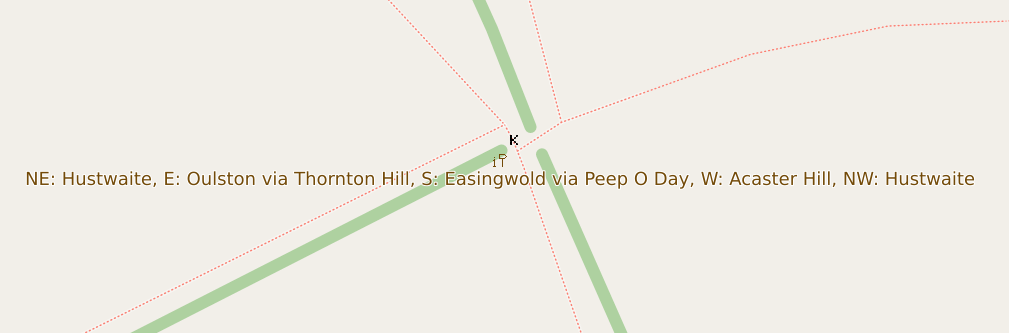
Signpost near Husthwaite

Although the raster maps at maps.atownsend.org.uk support zoom levels up to 24, until recently I’ve not made much use of that for showing extra data. However, there is a lot of room at these high zoom levels - as the picture above shows, enough for all the directions on this signpost here.

The name is shown as normal at lower zoom levels, then as you zoom in the directions are shown too, as you can see here.

Location: 54.155, -1.199
Posted by lhirlimann on 5 February 2024 in English.

Whilst attending FOSDEM in Brussels this week-end. Of course as I’m European I was able to use streetcomplete while roaming. So I did and collected a bunch of bagdes. While spending time with a friend, as we were walking to get/find food, I was playing. When I explained what I was doing, he got immediately interested in joining, so I demoed a bit more and had one more person going to map around his home.

Location: Melsbroek, Steenokkerzeel, Halle-Vilvoorde, Flemish Brabant, Flanders, Belgium

I’m Harrison, a hobbyist mapper based in Brooklyn, New York. I’ve been a map lover for as long as I can remember. Over the last few years I have gotten more involved in OpenStreetMap including my first trip to State of the Map US last year.

Mapping Projects

My ongoing “forever” project is mapping sidewalks in Brooklyn. With about 1,600 miles of roads there’s a long way to go! Beyond just mapping sidewalks I am working on adding curbs with accessibility details.

My most interesting mapping project has been working on the map at Train Mountain Railroad, the world’s largest miniature railroad. This started out as armchair mapping from home, then when I visited this last summer I worked on Mapillary “rail-level” imagery and other detailed mapping. The most exciting part has been the engagement from the community at the railroad getting engaged. The improved map has been immediately useful in the Train Game, and is being incorporated into a new track guide. This project has been fantastic as a complete study from all kinds of mapping to end data users.

See full entry

Posted by Filip009 on 4 February 2024 in English. Last updated on 6 February 2024.

EN:

A lot of new mappers are trying to edit existing element instead of creating new one and set properties to them. (For example some new mapper added amenity=pharmacy to whole apartment building insted of creating one node for it.)

Also I think it would be good idea to hide some existing layers for newies (at least boundaries). New mappers do not need to work with them, because they are not changing for a lot.

In iDeditor a lot of times happens that new mapper connect road with forest boundary, because he just moved node on way for a bit and iDeditor connected this 2 elements (This can be prevented by holding Alt, but new mappers do not know this). So we can at least think about layering OSM at least for new mappers.

Also when new mapper is crating new way, which is going in the same direction as some existing way (boundary or forest boundary) he many times connect this new way with existing one.

Proposed layers:

  • POI
  • buildings, highways, railways
  • landcover
  • boundaries

In JOSM I’m using filter to hide landcover and boundaries for most of time. Only when I want to work with landcover or boundary, only then I revert filter to show only this type of ways.

SK:

Čím viac sa nad tým zamýšľam, tým viac mi to príde vhodnejšie. Veľa nováčikov sa snaží niečo pridať, lenže väčšinou len upravia existujúce elementy namiesto toho, aby pridali nové. Taktiež si myslím, že by bolo vhodné nováčikom skryť aspoň hranice. V iDeditore sa nováčikom často stáva, že spoja cestu s hranicou lesa (Nevedia, že keď podržia Alt, tak sa im to automaticky nespojí). Takže môžme aspoň pouvažovať nad nejakými vrstvami v OSM.

Navrhované vrstvy:

  • POI
  • budovy, cesty, železnice
  • lesy, lúky, polia …
  • hranice

V JOSM mám väčšinou zapnuté filtre na skrytie landcover a hraníc. Iba, keď potrebujem elementy tohto typu editovať, len vtedy si filtre prevrátim.

it’s me again speaking from beyond the grave lmao!, todays diary entry consists of a bait and switch a user is trying to do first by removing a simple note from South Australias Major Traffic Network, and therefore after based on “Whats on the Ground” change the classifications of the road network to whatever the user feels. The problem with this is that “Whats on the Ground” literally has no authority over “actual nature of the road”. If this does not make sense please read the community link below.

https://community.openstreetmap.org/t/automated-edit-to-remove-note-on-highway-trunk-in-sa/108612/12

MAP

Posted by Magick93 on 1 February 2024 in English.
Map often
Map early
Map in the mornings
Map at noon
Map in the evenings
Map late at night
Map from dusk to dawn 
Map on weekends
Map daily 
Map every day in your heart
Map your town or city!
Map what you like
Map where you go
Map whenever possible
Map who you love
Map obscure and rare tags
Map for yourself
Map for humanitarian causes 
Map alone
Map together
Map to your heart's content
Map for Light, Life, Love & Liberty
Map !
Location: 19.490, -99.055
Posted by kmpoppe on 1 February 2024 in English. Last updated on 2 February 2024.

TL;DR: There are quite a few places on the continent that still need mapping. If you want to know why and how I came to that conclusion, read on ;-)

Preface

Since March 2023 there’s a handy bot called @SmallTownUSA@en.osm.town on the Fediverse, that posts a daily “task” out to its followers, highlighting “small towns” in the United States of America, that, to use the same phrasing, “seem like they could use some mapping”, along with a screenshot of the (Carto) map of the area.

Sparing the full technical details, the program randomly picks an entry from an overpass export of all nodes that have any place tag and a population tag with a value of less than 1000 (hence the name “SmallTown”) in the USA (currently 11389), asks overpass whether there are 10 buildings or less in 800 meters around that node and if so, posts about it.

As the bot has been doing this for about 10 months now, there seem to be at least 300 places that match the above description. Naturally, I wondered, how Europe would fare in comparison. Chatting with the bot’s developer, Matthew Wildon (OSM, Fediverse), they told me, that they checked France for potential candidates and found none and then didn’t look into it any further.

What’s on on the Continent?

My interest was now piqued. Would a similar “SmallTownEurope” bot make any sense, or would it run out of things to post within a week? Or is Pascal Neis’ Unmapped Places of OpenStreetMap Result Map enough to find areas where mapping is needed?

See full entry

Image by kai Stachowiak. License: CC0 Public Domain Image by kai Stachowiak. License: CC0 Public Domain

A few days ago I was in Bogotá, which at that time was affected by forest fires, which had raised interest in environmental issues in many people. In fact, at a mappers meeting, one of the topics of conversation was “what” to map to contribute in some way to making visible urban problems that are worsening with climate change.

The talk was long and rich and we all learned a little from each other. It is evident that more needs to be said about this so that people who want to contribute to mapping and in some way collaborate with climate change mitigation can easily find how to do so.

So, below are the mapping topics raised in that talk and some others that I added to the list as a result of conversations with other mappers.

See full entry

Location: 6.257, -75.614
Posted by Xvtn on 31 January 2024 in English. Last updated on 5 February 2024.

TL;DR

New users are requesting a review on their changesets, requests which go unanswered most of the time. We can use OSMCha to easily find them and review them.

“Review Requested”

When just starting out, I’m sure most of us have wondered whether we should tick the box stating “I would like someone to review my edits.” Ever wondered who is reviewing those when requested? Turns out, usually, it’s nobody. (See note below)

In my experience, brand new OSM contributors make mistakes frequently. Also, most new mappers don’t stick with it. Both of these points are OK, but we can correct the mistakes to improve data quality, and hopefully let new mappers feel welcome and like they’re part of the community.

The Solution

Fortunately, there is an excellent tool that makes it easy for experienced mappers to find newbie, review-requested, or suspicious changesets - OSMCha. You can also monitor your local area. It’s really fun!

  1. Go to OSMCha.org
  2. Log in with your OSM account.
  3. (Optional) Click on your OSM username dropdown, choose Account Settings. Remove text in “Review Comments Template”. If you don’t, when you verify a changeset as good or bad in OSMCha, it will make an aggressive-sounding comment on your behalf. I prefer to write my own comment on each changeset I review for new mappers.
  4. Click the Filters button and choose filters, see note 1 below.
  5. Click Save in the upper left so you can come back later without having to enter filters again.
  6. Pick a changeset on the left bar, review the changes, and optionally leave a comment. See note 2 below.
  7. In the upper right, verify the changeset as good or bad, and maybe add tags. (You can always change things later.)

Notes

Changeset Filters

For reviewing new mappers’ changesets, here are the filters I use:

  • Location - Draw a border around my local area. (I review all in Utah and some in USA west)
  • Reasons for Flagging - “New Mapper”, “Review Requested” (Set to AND!)
  • Review Status - “Not Reviewed”

See full entry

Posted by Eden Oluigbo on 31 January 2024 in English.

Exploring Career Opportunities in Open Source

image showing inclusivity

Sometimes, evaluating an end goal before beginning a journey can be good, especially as regards to career. And if you’re wondering what the next 1 - 3 years look like for someone committed to open source, then I’m happy to explore with you some interesting career opportunities in the open source community and share my story as well.

I was in a tech conference some years back, and during a chit-chat/mingle session before the speakers came on stage, the phrase “open source” was flying around, literally. I got confused and I was having another small chat with myself in my mind, what exactly is open source?

Could it be the company got sponsored by the public? As in “open source?” Haha! I had no idea what everyone was talking about and I was eager to begin the training so that I could learn from the speakers.

See full entry

My reflection about SotM Africa 2023 held in Yaoundé, Cameroon which focused on the theme “Open Mapping as a support tool for local development in Africa”. The State of the Map Africa (SotM Africa) is a bi-annual regional conference that celebrates the culture of open mapping, open data, GIS and its impact across Africa. It was a great opportunity for mappers, GIS & Open Mapping enthusiasts, data users, and other stakeholders in the OpenStreetMap community to come together, share knowledge, and collaborate on projects.

• Presentations and workshops: The variety of presentations on topics related to OpenStreetMap, and GIS such as Field mapping techniques, data analysis, and community building. I learned about new tools, methods, and techniques, and also gained insights into the challenges and opportunities facing OpenStreetMap in Africa and how we can collaborate together to develop and solve Open Mapping & Data challenges in Africa.

• Networking: The conference offered a great opportunity to meet with other people from other part of Africa & world, who are passionate about OpenStreetMap. I was opportune to make new friends, (the Likes of Kennedy, Yves Emmanuel, Charles, Emmanuel, Janet, and the OSM Cameroon team), established professional connections, or found collaborators for future projects

• Cultural and social Night experiences: The conference was also a chance for me to experience the Cameroonian culture especially during the social night event seeing different culture, dancing steps etc., I enjoyed the hospitality offered, local food, music, and dance, and learned more about the history and traditions of Cameroon.

See full entry

Location: Zoatoupsi, Mbankomo, Méfou-et-Akono, Centre, Cameroon

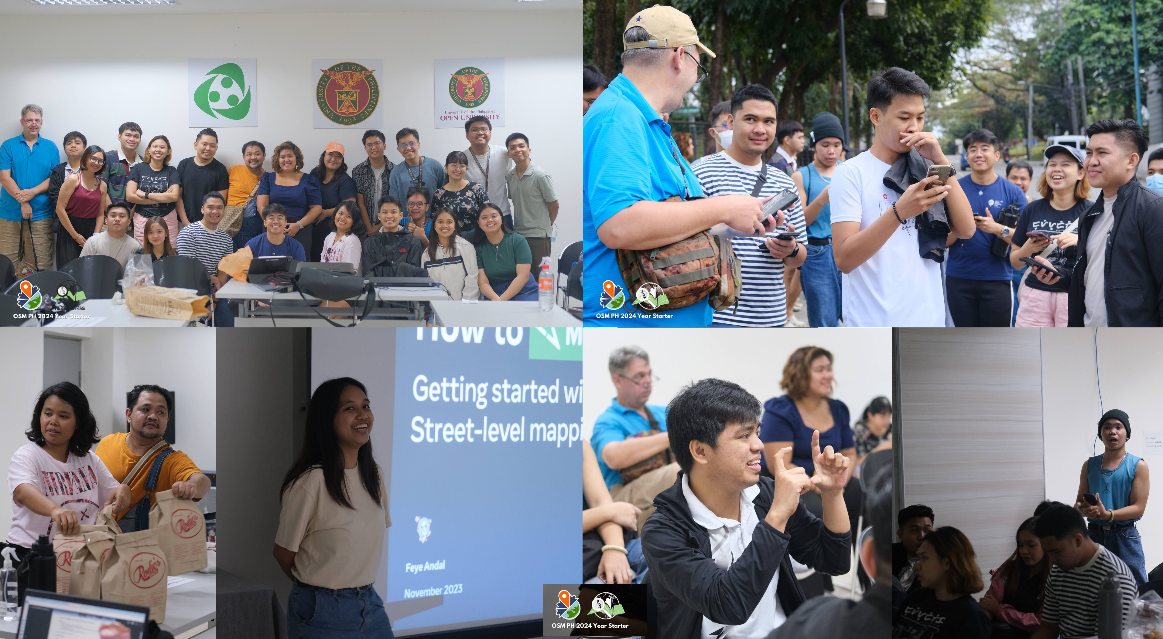
#OSMPHarin2024 - mappy is a happy word!

Credit: Photos from UPRI Youthmappers

Had so much funnn and so mappy from last Saturday’s OpenStreetMap Philippines’ 2024 Year-Starter mapping party #OSMPHarin2024* !

THANK YOU for everyone who has participated, and spent time with us and for mapping!

OSM PH community members’ aspirations

For introduction and icebreaker, our wonderful host (Jikka) asked us to introduce ourselves and share our aspirations for the 2024. Since some participants are new/beginner to OSM, aspirations can be personal and/or OSM-related.

From learning how to swim, graduating this year (lots of them are students from UPRI), healthier lifestyle (more sleep, eating on time and exercise) to growing the community and being more involved in OSM, we are really aspiring this year! Hope to go back to this and see by end of the year!

OSM field mapping and mobile tools

See full entry

Location: UP Campus, Diliman, 4th District, Quezon City, Eastern Manila District, Metro Manila, 1101, Philippines