Diary Entries in English

Recent diary entries

Posted by spwoodcock on 7 December 2023 in English. Last updated on 21 February 2024.

To GDAL or not to GDAL

GDAL is an incredible geospatial library and underpins so much of what we do, including our databases (PostGIS).

However, sometimes it might be a bit heavyweight for what we are trying to achieve.

Installing it as a base system dependency inevitably installs everything - there are no options.

image

Install size is especially important when building container images, that we want to be as small as possible for distribution.

GDAL in PostGIS

PostGIS uses GDAL for most of it’s geospatial processing, including reading and writing various geospatial file formats.

FMTM is starting to use FlatGeobuf format for various purposes (OSM data extracts, storing submissions).

It also uses a PostGIS database as part of the software stack.

So today I thought: why not just use the geospatial processing built into PostGIS for reading and writing flatgeobuf data?

The solution was surprisingly painless!

Database Access

First we need a way to access the database.

See full entry

Location: Kuala Lumpur City Centre (KLCC), Bukit Bintang, Kuala Lumpur, Malaysia
Posted by jcr83 on 5 December 2023 in English. Last updated on 7 January 2024.

Version française

Introduction

Many paths, tracks and even small streets are missing from OSM. And yet, these paths are often used by Strava users, who upload their traces there. So I thought it would be interesting to use these data to improve OSM.

That’s why I wrote a Python program which, by analyzing Strava data, is able to detect missing paths in OSM, then generate files to create MapRoulette challenges so that each missing path can be added to OSM.

What is Strava?

According to Wikipedia, Strava is a website and mobile application used to record sports activities via GPS. Its members use devices such as a GPS watch or smartphone to record their running activities, and send these to Strava. Currently (2023), there are over 100 million members.

Strava heat maps

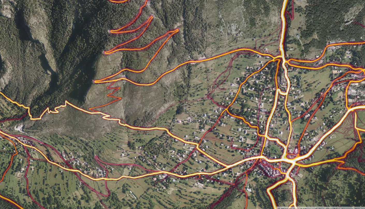
On its website, Strava publishes a heat map showing the aggregation of all its users’ tracks.

Example: Strava heatmap example

The more a route is ridden, the brighter its track appears on the heatmap.

See full entry

Posted by Eden Oluigbo on 5 December 2023 in English. Last updated on 10 December 2023.

👋🏼 Hello and welcome to my blog space where I share everything about my journey with Outreachy, HOTOSM and more. Thank you for joining me on this exciting journey! I am very excited to be part of the Outreachy program and If you’re interested in knowing the rest of my story, which I am willing to share it all :), please subscribe to my posts, so you get notified every time I publish a blog on my journey. Just like everything that ever existed, there’s always a beginning. So let’s zoom🔍 out a little bit to where it all began 😊.

image that says "the journey is on"

Introduction

My name is Eden Oluigbo. I am a full-stack developer, artist and creator living in Abuja, Nigeria. I'm an open-source advocate and love contributing to the improvement of open source software. I started an active contribution to open-source projects in 2022. I joined different communities, made contributions and got PR merges (that excitement of having your PR merged never gets old haha😁).

Why Outreachy?

See full entry

Posted by nukeador on 5 December 2023 in English. Last updated on 6 December 2023.

This is a cross post from the HOTOSM blog.

As Community Strategist and Research Lead at HOT, I would like to take a closer look with you all at the evolving landscape of OpenStreetMap (OSM) contributors, especially in the context of local knowledge and its crucial role in our mapping efforts.

Summary

Our recent study reveals a trend in local knowledge contributions in OpenStreetMap: a small but dedicated number of local mappers, making up just about 3% of contributors who are in the area mapping, is responsible for approximately 75% of the detailed mapping contributions.

This significant finding underscores the vital role of local knowledge and expertise in creating comprehensive and accurate maps, especially in humanitarian and unmapped/under-mapped regions. Despite a general decline in new OSM contributors, the impact of this core group of local mappers remains profound and indispensable for the future of the project.

We would like to engage researchers and mapping communities to unveil what are the implications of these numbers and the opportunities to use them to better support mappers.

The Spark of Inquiry: Simon Poole’s Analysis

Our journey began with Simon Poole’s important observation: a 20% drop in new OSM contributors. This sparked intense discussions within our team and motivated us to investigate further, particularly focusing on regions where HOT is actively involved.

See full entry

Posted by joyceeemaeee on 4 December 2023 in English.

Another year, another Pista ng Mapa 2023 in Tacloban City!

Hosted by UP Visayas Tacloban YouthMappers, it’s a gathering celebrating open mapping, data, and an unforgettable journey. I am grateful to the organizing team for the scholarship grant and the chance to present. Thank you, UP Tacloban Youthmappers, for the warm welcome and for keeping our surroundings pristine.

The conference was a three-day journey packed with eye-opening lightning talks. From Leanne Caye D. Obispo’s “Data: A Story to Tell” to Sir Denrazir Atara’s spatial analysis of tree species, each session was a revelation. Erika Del Rosario Pauline Jen Madrona’s drone training and Oriel Jay Ibañez’s insights on community development through drone imaging were inspiring. Sir Ben Hur Pintor’s discourse on data management and Ms. Dinnah Feye Andal’s introduction to Mapillary were eye-openers. And oh, the endless field trip—such a blast! where I can say I shall return to Tacloban

Meeting old friends, making new ones on social nights, connecting with mentors again like Sir Mikko Tamura, Ms. Feye Andal, Leigh Lunas, Sir Ben Hur, and Sir Aimon, and connecting with the local YouthMappers chapters were a highlight! This was my 2nd Pista ng Mapa 2023, a great adventure with a small team with Dora (Me), yet the knowledge gained, networks built, and friendships forged were beyond measure. Here’s to hoping next year brings even more from our chapter.

I look forward to creating new memories and deepening my mapping passion at the next Pista ng Mapa (also SotM, manifesting!). Huge thanks to everyone who made this event an unforgettable experience!

Location: Brgy. 2, Downtown, Tacloban, Eastern Visayas, 6500, Philippines
Posted by KAWAMALA on 4 December 2023 in English. Last updated on 23 January 2024.

Thank you

GISDAY2023

Asante sana

Your participation in 2023 GIS Day Conference was hugely appreciated

"Geospatial technology stands as a cornerstone for fostering a robust digital economy in Tanzania,serving as a catalyst for achieving sustainable development that will secure a prosperous future for forthcoming"

Dr. Moses Nkundwe Mwasaga, DG ICT Commission

Throughout the conference, we witnessed over 200+ participants gathered at the Tanzania Commission for Science and Technology (COSTECH) in Dar es Salaam to exchange knowledge and participate in dialogue on utilising geospatial technology for sustainable development in Tanzania.

The conference brought together geospatial enthusiasts, leaders, and practitioners across industries, the private and public sector, academia, and civil society organizations to promote changes that can be made at the community, producer, and government levels for sustainable development.

Engaged participants included:

See full entry

Location: University Residential Houses, Kijitonyama, Kinondoni Municipal, Dar es-Salaam, Coastal Zone, 25195, Tanzania

A few years back, I successfully led a crowdfunding effort to raise £975 to purchase scans of the 1970s / 1980s 1:50k topographic map series of South West Africa / Namibia from a commercial map archive. It was a great success and I put them online: https://namibia-topo.openstreetmap.org.za/

Recently I have been speaking to the archive again about purchasing similar map series for other African countries. The map series vary per country from the 1960s to 1990s. Many were created with support from the United Kingdom’s former Directorate of Overseas Surveys (DOS).

The 1991 1:50k Topographic series of Swaziland (now Eswatini) published by the Swaziland’s Surveyor General is available. It is made up of 31 sheets in total. The scans are supplied clipped and unclipped. Total price is US$ 400 for the scans.

It would be fantastic to get these maps online. Would you be willing to support this purchase?

Link: Worldcat reference for the 1991 Swaziland map series.

See full entry

Location: Mbabane, Inkhundla Mbabane, Hhohho Region, H100, Eswatini

Hello, i’m maplemoths. This is my first diary entry, and i decided it’d be fun to discuss OSM topics occasionally here.

What have i been mapping recently?

I’ve been doing tons more mapping recently, because it’s pretty fun. It’s nice to just listen to music/twitch stream vods, and just map. Here’s what i’ve mapped recently.

Hawai’i

Most recently, i’ve been mapping in Hawai’i. A large amount of my edits actually are in Hawai’i in general, because i used to live there. Specifically, i’ve mostly been editing in the city i lived in, Hilo. When i first started mapping in i believe September of 2022, Hilo’s map quality wasn’t super good. Lots of missing landuse or POIs, lots of stuff that was all offset from eachother, the polygons were really messy, etc. But, i feel like there’s been tons of progress! I’ve been working on making things better, and there’s been some progress from others. There’s been more landuse, i cleaned up lots of the messy/incorrect polygons, and i’ve also micromapped the zoo right outside of the city, but i’ve also done some other stuff in the area.

Plains, Georgia

A lot of times, i map an area because something interesting has happened there, or that it’s significant for an interesting reason. Examples include me mapping Oleona in Pennsylvania because the area was the site of a small failed Norwegian colony, and yes, Plains, Georgia. It’s a small little town right in the south of Georgia that’s famous for being the hometown of US president Jimmy Carter, so i decided to map it! I mostly did landuse and cleanup, and it was quite fun! If you’re wondering, i did not map the town because of Rosalynn Carter’s death, i started the project a month earlier but only finished it after.

What do i plan to do next?

This section is for stuff i want to get to, and maybe i can get some help on if you want!

More Hawai’i

See full entry

Posted by DW2515 on 1 December 2023 in English.

Dear OpenStreetMap Community, As we celebrate the vibrant spirit of OpenStreetMap (OSM) and the incredible progress it has made over the years in the upcoming annual meeting, I am excited to express my interest and enthusiasm in becoming a potential board member for the OpenStreetMap Foundation.

While I may not boast thousands and thousands of edits on the OSM platform, I have dedicated my efforts to advocacy and education, recognizing the which I think play a crucial role these aspects play in fostering a thriving OSM community. My journey with OpenStreetMap has been one of constant learning, teaching, engagement, and a commitment to making OSM accessible and valuable to people users around the world.

From when I made my first OSM edit in Nepal during a HOTOSM & Maptime Miami Mapathon. (Maptime is a global volunteer meetup group that teaches beginners and experienced folks alike about mapping, geography, OSM and more.) Since then I have volunteered to teach others about OSM in a few ways, such as through Maptime meetups, where I served as the leader of Maptime chapters in Miami and Boston, and to teaching the basics of geography and OSM to Young African Leaders Initiative (YALI) fellows about how they can use and apply geography and OSM in their communities, to leading Maptime chapters in Miami and Boston (as I moved around).

See full entry

Posted by spwoodcock on 29 November 2023 in English. Last updated on 6 December 2023.

See pt1 of this series here.

First Release

We have been running various versions of FMTM for some time now, but released our first official version not long ago: v0.1.0.

FirstRelease

See the excellent release notes written by Susmina Manandhar, product manager for FMTM, for further details of features, bug fixes, and improvements.

Just to reiterate what a wonderful team of devs we have working on the project: @varun2948, @nrjadkry, @Sujanadh, @NSUWAL.

Special thanks for @JoltCode, an volunteer, who helped to modernise our frontend build tools. And to @robsavoye for his work on osm-fieldwork and osm-rawdata that underpin FMTM, plus guidance from the start.

Try it out!

I have been working to ease the installation process for organisations that need to run FMTM.

You can run a version of FMTM yourself with two commands!

curl -L https://get.fmtm.dev -o fmtm.sh

bash fmtm.sh

You will be prompted with a command line interface

See full entry

Location: Tanjong Tokong, North-East, George Town, Penang, 10470, Malaysia

Tl;dr: this is a somewhat technical post, so if you are interested primarily in finding alternatives to OSM Analytics, please scroll down to the last section. This post is being created in conjunction with a Community Forum topic as well, so any feedback or comments should be directed there.

Background

What is OSM Analytics?

For the past 8 years HOT has been supporting the hosting and maintenance of OSM Analytics. This service was built by Martin Raifer, hired by HOT with support by the Knight Foundation. It was originally developed to help people analyze and visualize OSM data it multiple ways:

  • Density and distribution of OSM features such as buildings, roads, hospitals, amenities, places and waterways from aggregated low zoom levels (world scale) all the way to individual features;
  • Total count of OSM features over different areas, including any admin boundary, user defined area of interest or custom GeoJSON;
  • Recency of edits displayed in a timeline graph, allowing users to select specific time periods and visualize the corresponding edits on the map
  • Visual distribution of features mapped by OSM contributors with different levels of experience, allowing interactive selection of experience levels and automatically displaying relevant features
  • Gap analysis, showing areas of estimated completeness with regards to buildings mapped;
  • Change over time, allowing users to compare density, distribution and total count of OSM features in any area at any zoom levels, between any two years from 2007 to now
  • Top OSM contributors and top distinct tags for any user defined areas, allowing interactive filtering through the timeline slider selector

Technical functionality

See full entry

Posted by revent on 28 November 2023 in English.

I have been working on placing the boundary in the correct location, or at least as “correct” as is technically possible. Before I started this, the boundary was mostly mapped using (as best as I can tell) data from the Canadian “Canvec” and “Geobase” datasets along the St. Croix River, and the NAD83 coordinates published by the International Boundary Commission in Passamaquoddy Bay. This was roughly correct in most cases, but some in some places the boundary is/was completely on the wrong side of the river. Essentially, we have been using the edge of the Canadian hydrography dataset as the national border.

The actual border

The actual position of the border is defined by the Treaty of 1908, as modified by the treaties of 1920 and 1925. The text of these treaties can be found on the website of the International Boundary Commission. The general message from actually looking at them is that the determinations and demarcations of the IBC are “definitive”… the boundary is where the IBC says it is, in their official publications and on their official maps.

These publications can be found in scanned form on HathiTrust. All but Special Reports 8 and 9 predate the adoption of the North American Datum of 1983… this means that the official position of most of the boundary is actually defined in either the pre-1927 United States Standard Datum, or the North American Datum of 1927.

While the IBC does publish a shapefile of the boundary (in NAD83) and a “coordinate listing” for each section in both NAD27 and NAD83, these files are of limited use. They are explicitly stated to be not official, and I have found obvious typos that would locate the border miles out of position. Also, the given NAD83 coordinates are unhelpful since they do not state which “realization” of NAD83 they are in. OSM is capable of storing coordinates to a degree of precision at which this makes a difference.

Obtaining correct coordinates

See full entry

Posted by imagico on 26 November 2023 in English.

I am happy to announce that after a long time we, the OpenStreetMap Carto maintainers, have prepared a new release of the OpenStreetMap Carto stylesheet (the default stylesheet on the OSM website). Once changes are deployed on openstreetmap.org it will take couple of days before all tiles show the new rendering.

Here are some details on the visible changes this release brings to the style.

Changing color of leisure=pitch to be more distinct and less similar to the water color

The color of leisure=pitch had a long time ago be adjusted to be less strong. But this change had resulted in pitches often being hard to distinguish in the map from water areas and other green areas even though pitches are a highly distinctive feature that is typically small in size - which calls for a strong color in principle. This modification changes the color of leisure=pitch to be more distinct and recognizable again and at the same time to harmonically integrate with the other colors used.

leisure=pitch color change

See full entry