Diary Entries in English

Recent diary entries

Posted by cyrusyg_ on 20 October 2023 in English.

UNIQUE MAPPER A Poem by Cyrus Aladja

Growing up and coming into age Really never belonged, truly felt different Like a bird, free to roam never in a cage Now it’s dawn I clearly see and here’s the difference

It strange nor weird, oh this bird is no freak It’s long overdue, this bird is no longer shy Maybe by chance it hatched in a pen with chicks But it’s time now to take its place in the sky

High up in the clouds to see the world and conquer Coasts to coasts, nations to nations, city to city all therein Cause now all eyes can see this bird’s a wonder Flying on Eagle’s wings, with grace and so so serene

Now it’s clear, the bird is unique Created and formed by our maker A bird high in the clouds is unique! This bird is a unique mapper

Location: NEPA, Port-Harcourt, Rivers State, 520052, Nigeria

Just a few short weeks ago I made the decision to map all house numbers in Lancaster. Of course, I understood what an undertaking this is, so I set off on a search for good ways to view and add this data. Ultimately, I found myself at Lancaster’s GIS Website. After consultation with the OSM discord, I considered it safe for use and began to map them by hand using JOSM.

This leads me to why I personally believe house numbers to be so important. Through personal experience, I would consider house-to-house navigation far more used than routing to a business. If a map has no house numbers, then that may rule a large number of people completely unable to use such a map. This is why I seek to map house numbers.

After about a month’s time of mapping (plus life getting in the way) I would say I’m about 5% done. Slow progress, but progress nonetheless!

If any others would like to join my mission for mapping Lancaster’s addresses, it would be much appreciated!

Location: Lancaster, Los Angeles County, California, United States
Posted by Matt_ on 19 October 2023 in English.

I pulled together some info I wanted to share: what is the longest connected group of untouched TIGER imported roadways in the U.S.? The answer is this 1258.6km group of ways in Brooks County, Texas. And then below will be the rest of the info I found. I haven’t done anything with it, I just wanted to share.

Note: the Overpass queries I link directly to are all relatively quick since they’re just lists of way IDs. But for some of them I link to pastebin since they were too long to pass in a url.

Overpass Turbo - Brooks County, TX Results from Brooks County, Texas

Idea

The full results are here as a spreadsheet but I also want to explain.

I was looking at the results of the query for unedited ways and nodes in an area near me and noticed there were way more untouched roads than I thought there would be.

See full entry

Posted by James_OWORNTE on 19 October 2023 in English.

Sotm Nigeria 2023 Abuja was very very impactful to me. Especially, having the privilege to present a topic titled ‘The Role Of Open Street Map On Emergency response. I want to use this opportunity to say thank you to all our sponsors for paving way for some volunteers who could not afford it to the conference physically, by giving grant which I also benefited from it. I’m looking forward to mapping more using open street maps and having more opportunities to participate in conferences and events coming up in the merest future. Once again I say thank you, I really do appreciate. 🙏

Posted by gvwaal on 18 October 2023 in English.

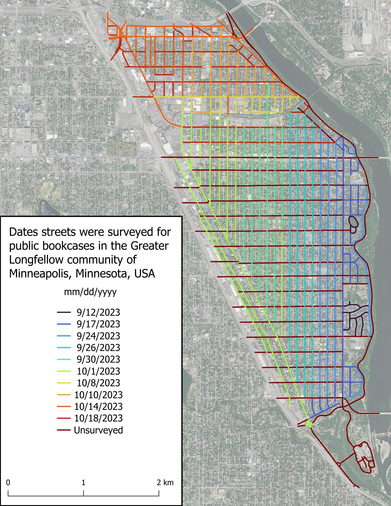
All* of Seward is surveyed! I found very few public bookcases (PBs) when surveying the remaining streets, which wasn’t surprising because most people put their PB in their front yard, and in Minneapolis, most front yards are on the avenues (north-south roads).

*It’s possible there are PBs in the entryways or at the base of large apartment complexes, and I didn’t attempt to circumnavigate each large apartment as that would have involved leaving the street.

Intro

Part 2

Part 3

Figure displaying dates roads were surveyed in the scope area. Roads are colored based on date, with the earliest date, 2023-09-12, in very dark blue and grading to red for unsurveyed roads.

It’s another previllage and opportunity to the part of local organizing committee (LOC) beand community volunteers and also selected as travel grantee to attend the hybrid state of the Map conference in Abuja Nigeria. collaborations with national research and development agency (NARSDA). It was very inspiring moment and knowledge shared was super amazing. I’m getting so much interesting In researching with geospatial tools after the presentation of #Afrigis, #cartoscope and #scistarter and Geoffrey keganttera presentation on food production system in Uganda was very educative . And also discussed more about technical support to local community members of open street Map foundation and sponsorship. I’ll like to appreciate the west and North African hub(WNH) for there special support to unique Mappers . (Afrigist)(URL) *##@{Alt picture}URL

Location: Kyayya, Barde, Jema'A, Kaduna State, Nigeria

It’s another previllage and opportunity to the part of local organizing committee (LOC) beand community volunteers and also selected as travel grantee to attend the hybrid state of the Map conference in Abuja Nigeria. collaborations with national research and development agency (NARSDA). It was very inspiring moment and knowledge shared was super amazing. I’m getting so much interesting In researching with geospatial tools after the presentation of #Afrigis, #cartoscope and #scistarter and Geoffrey keganttera presentation on food production system in Uganda was very educative . And also discussed more about technical support to local community members of open street Map foundation and sponsorship. I’ll like to appreciate the west and North African hub(WNH) for there special support to unique Mappers . (Text)(URL

Location: Kyayya, Barde, Jema'A, Kaduna State, Nigeria

It was indeed a great privilege attending the SOTM Nigeria 2023 conference in Abuja, at the Obasanjo Space Centre.

I was also a participant last year at the maiden edition of the SOTM conference 2022 in Port Harcourt. This participation aroused my interest and I have not looked back ever since. This year my very good friend and sister Hopeful Bafamodei invited me to be a part of the panel that talked about the cultural perception of genital mutilation. Thereafter my co panelist shared how mapping is needed to get data from areas identified as code red, where genital mutilation is being practised and how with the use of these data collected, help can come to such communities. Right there we had a live participant who shared her experience of what she had to go through in the hands of her very own father. I want to appreciate most importantly Dr Victor Sunday and all the LOC who made this event possible, The presentations made by Ian Tobia, Makcron, Eromosele and Hopeful, thought me one thing…….RESILIENCE. My passion for this conference is growing by the day and I am looking forward to more engaging content to be discussed during future events.

Hi, I use Street Complete a fair bit and it often shows up buildings with their areas drawn and asks what type of building it is.

But when I map some areas, the online editor won’t let me close the save set without having features for each area. If I choose generic “building” I don’t think StreetComplete is asking me anything at all, as though it has been settled.

So what’s a default feature for an unknown building (or unknown area for that matter - some bright white objects are very hard to tell if concrete, on the ground or a roof.) ??

Posted by Klenje on 16 October 2023 in English. Last updated on 22 October 2023.

One of the greatest things in OpenStreetMap is that, when you start looking beyond the basic features, the amount of details and specific themes you can use to enrich the map is practically endless (special mention for the guard stones mapping)

An example which may go unnoticed at first is playground mapping. I became interested in this due to the frequent visits, and I started as usual from the wiki.

The goal of this post is to have a quick summary on how to map playgrounds in order to hopefully help fellow mappers around the world interested in this topic.

Why

Because having the data in OpenStreetMap will allow your favorite app/website to let you search and display easily the existing playgrounds and their features, removing one more reason to use other providers, while making kids and parents happy.

How to map

Level 0 - starter

Minimal mapping is to place a node tagged with leisure=playground in the playground location.

Note: in some places you can also find single play installations which are not part of a playground, those can be mapped directly as nodes without a playground.

Level 1 - basic

Map the playground as an area and add tag leisure=playground and any other relevant tag on it (wheelchair access, minimal age and so on). This opens up the possibility to go further into details as explained just below.

If the playground has a fence, you can also add that to the playground area with the relative gates (and possibly some footways to reach them for the routing engines!)

Level 2 - medium

Map the devices and installations as nodes within the playground area. You can find a detailed list of possible values on the wiki.

Besides that, you can also map any additional amenity like benches or drinking water that are located within the playground area.

Level 3 - advanced

See full entry

As I reflect on my journey to the State of the Map Nigeria 2023 (SotM Nigeria 2023) conference, the words that come to mind are unforgettable, inspiring, and hopeful. This year’s event was a unique blend of challenges and triumphs, new friendships, and a shared vision for the future of open mapping in Nigeria.

Unforgettable Connections: The most remarkable aspect of SotM Nigeria 2023 was the people I had the privilege to meet. Despite the challenges posed by limited funds and logistical hurdles, participants from different corners of Nigeria and beyond gathered in Abuja with a shared passion for open mapping. Each conversation was a new opportunity to learn, collaborate, and inspire one another.

Inspiring Endeavors: The conference sessions were a wealth of knowledge and inspiration. From innovative mapping technologies to community-led projects, the presentations showcased the incredible work happening within the Nigerian open mapping community. The dedication of speakers, volunteers, and attendees left me inspired and eager to contribute to these initiatives.

Hope for the Future: While navigating the constraints of limited funds, we shared a collective hope for a brighter future. The challenges we faced underscored the importance of growing support for open mapping in Nigeria. I was fortunate to witness the commitment of the organizing team as they worked tirelessly to make the event a success, and I left with hope that future SotM Nigeria conferences will have the resources needed to flourish.

SotM Nigeria 2023 was a testament to the resilience of the open mapping community in Nigeria. Despite the obstacles, we came together, learned, shared, and celebrated our common goal. The connections made, knowledge gained, and the spirit of collaboration will continue to inspire me as I work towards a more vibrant open mapping landscape in Nigeria.

See full entry

In a world where technology is at our fingertips, it is easy to forget that not every corner of the globe has been extensively mapped or can enjoy the benefits of modern cartography. This is especially true in regions torn by conflict, where infrastructure and basic services have been devastated. South Sudan, a nation born out of conflict, is one such place where mapping takes on a unique and critical role.

South Sudan, the world’s youngest country, has been grappling with conflict since its inception in 2011. The violence has often been drawn along tribal lines, making reconciliation and rebuilding particularly challenging. In such a fragile post-conflict environment, the work of organizations like OSM South Sudan takes on profound importance.

The OSM South Sudan Initiative

OSM South Sudan, an open mapping community, has taken up the mantle of mapping the nation’s remote and conflict-affected areas. Mapping in such an environment is not just about geographical data; it is a tool for social healing, reconciliation, and empowerment. The volunteers involved in OSM South Sudan are driven by the belief that the act of mapping can foster peace and unity in a divided land.

Concept Mapping as a Starting Point

To initiate this endeavor, OSM South Sudan starts with a fundamental step – concept mapping. The first phase of their approach is all about introducing the local communities to the concept of mapping in a way that resonates with their everyday lives. By asking simple questions like, “What would you do before you build a house?” the volunteers create a bridge between mapping and the participants’ own experiences.

See full entry

Location: Hai Buluk, Juba, Central Equatoria, South Sudan
Posted by Karinorz on 15 October 2023 in English.

Introduction

Open Her Map team was consisted of 3 people, Mirnayani (Indonesia), Shafiya (Sri Lanka), and Karina (Indonesia). As a follow up of She Leads She Inspires program, Open Her Map was selected to be one out of 10 grant beneficiaries to make a platform to gather information related to the availability of women-only spaces in public facilities, such as the availability of breastfeeding rooms, kids’ playing spaces, women-only restrooms, ladies’ parking spaces, women-only rooms, women-only hours service, and many other women-only spaces’ necessities.

Outcome

By the end of the project, the project achieved the following: Women participants have increased sense of safety and comfort in terms of women-only spaces in public facilities One pilot location in each Jakarta and Moratuwa have increased the number of mapped women-only spaces in public facilities Women participants have increased knowledge on mapping women-only spaces using OpenStreetMap

Output

See full entry

Location: RW 10, Pela Mampang, Mampang Prapatan, South Jakarta, Special Capital Region of Jakarta, Java, Indonesia
Posted by gvwaal on 14 October 2023 in English.

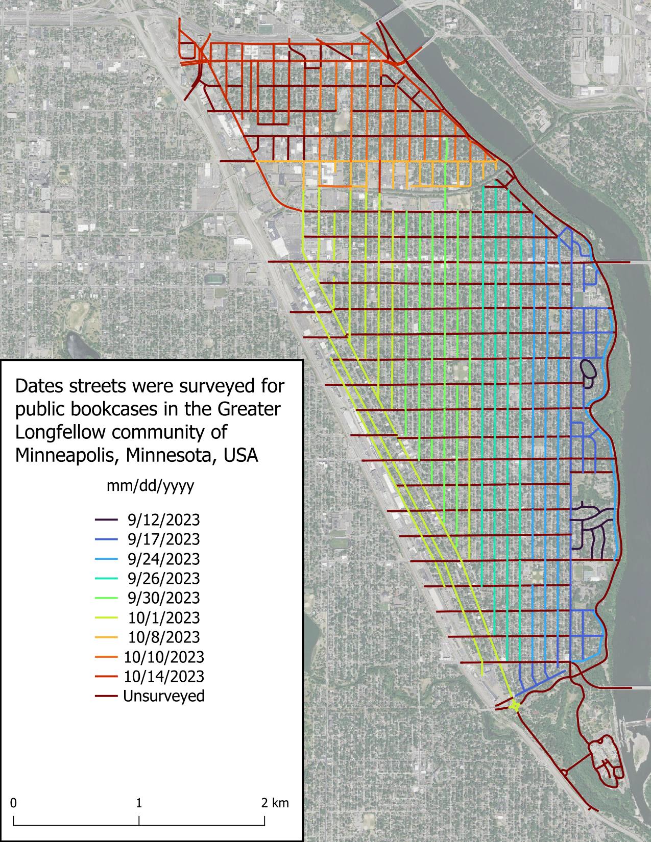
I surveyed most of Seward’s avenues today, but what I’m most excited about is having finished surveying the three streets I was least excited about (9th St S, Franklin Ave E, and Minnehaha Ave S), leaving calmer streets for the rest of the project.

Unsurprisingly, I found few public bookcases (PBs) today. I believe this is due to the non-single family home nature of the roads surveyed, and in the roads lined with single family homes, the economic conditions of the inhabitants.

Shoutout to the Feminist Book Club for being the only non-residential entity (witnessed so far) to host a PB.

Intro

Part 2

Figure displaying dates roads were surveyed in the scope area. Roads are colored based on date, with the earliest date, 2023-09-12, in very dark blue and grading to red for unsurveyed roads.