Diary Entries in English

Recent diary entries

Posted by darkonus on 29 June 2023 in English.

I want to share my experience using the CAD Tools plugin for drawing ways with smooth bends in JOSM. I want to emphasize that I don’t claim that this mapping method is the right or useful one. Most mappers tend to show object contours with as few points as possible. I see the advantages of this approach as it makes data easier to edit, especially in mobile and browser-based OpenStreetMap editors.

On the other hand, smooth line bends work well for the shape of most objects we map. Roads, being one of the main features on maps, are always represented by smooth lines best described by Bézier curves. Coastal lines of various water bodies almost always have smooth bends.

My considerations are as follows: the closer the data represents the true shape of an object, the more accurate the data is. Ultimately, my main motivation is that smooth lines are very aesthetically pleasing.
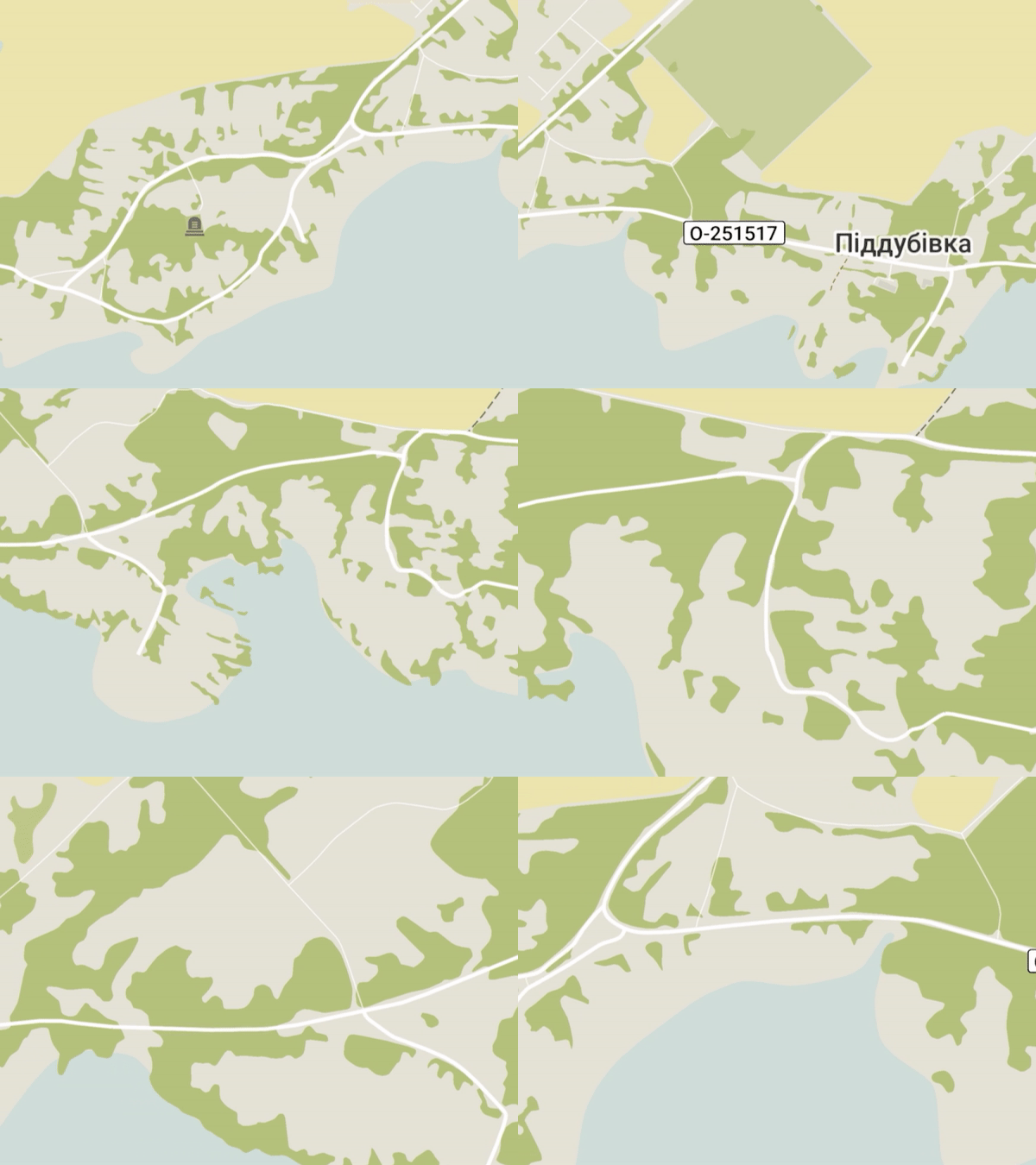
OpenStreetMap in Organic Maps

See full entry

Location: Dubyna, Starokostiantyniv Urban Hromada, Khmelnytskyi Raion, Khmelnytskyi Oblast, 31115, Ukraine

Continuing last week’s trip from Duluth, MN to Ashland, WI with a loop around Bayfield County.

Now that I’m on the lake shore, I started seeing a bunch of bikes around, even where there isn’t much bike infrastructure.

Ashland, WI

Around 1900, Ashland was the third-largest Great Lakes port after Chicago and Buffalo. In recent years they have reclaimed the waterfront ore dock and brownfields for parks. A paved trail connects beaches to downtown and the Wal-Mart.

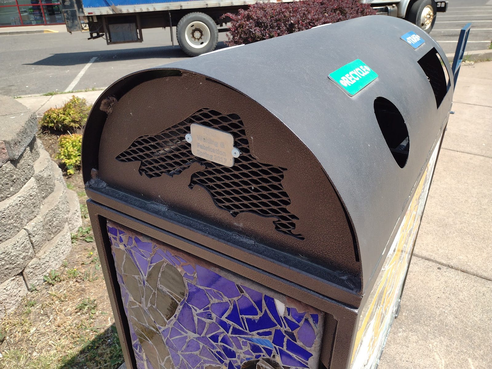
When I arrived in Ashland, I locked the bike at the library. Semi-recently (after the 2015 StreetView), the city got Lake Superior-themed bike racks along Main Street. There could be more of these. The local high school is making these and Lake Superior-themed trash cans.

See full entry

Location: Bayfield Historic District, Bayfield, Bayfield County, Wisconsin, 54814, United States

An Impulse Buy

I recently bought a GoPro MAX on sale for $400, with the intent of collecting footage for Mapillary. However, I have yet to get the desktop app working on Ubuntu 22, and haven’t been able to authenticate using their CLI tool, so I haven’t uploaded anything.

Mounting the GoPro on my car

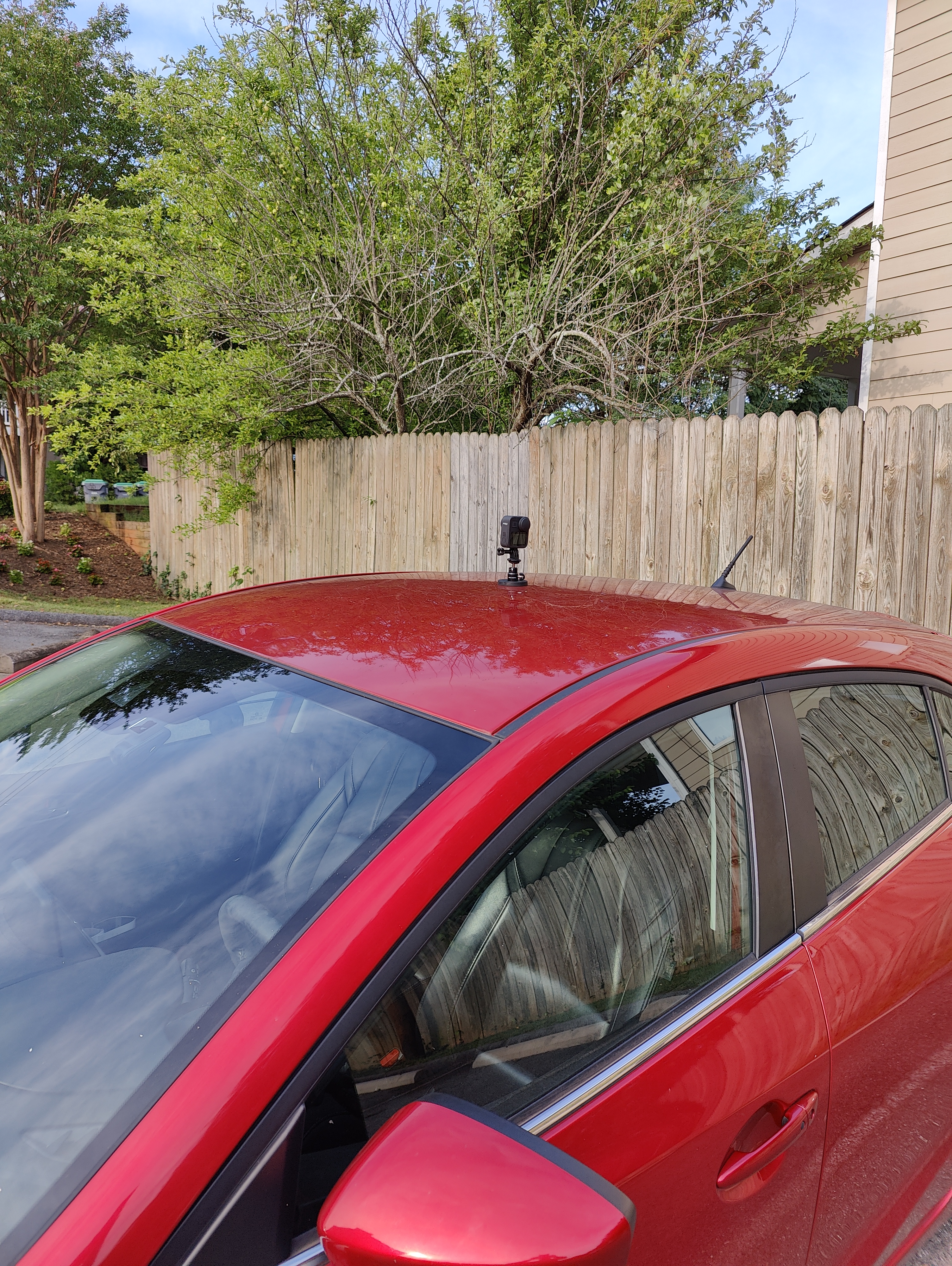
I’m using a magnetic mount to attach the gopro to the roof of my car. I was a bit nervous driving at highway speeds, but so far it’s held up going around 50 mph. The magnet is quite strong and takes some force to remove.

A gopro MAX mounted magnetically on my car

Processing the video locally

As a workaround, I’m just analyzing the footage locally using the mapillary_tools utility to locally process the footage into geotagged images and JOSM to view them.

This has the added advantage of preserving my privacy, since I’m a bit concerned about giving my geotagged video to Meta. This way I only upload a limited amount of data relevant to what I’m surveying.

See full entry

Posted by Kai Johnson on 25 June 2023 in English.

In the course of working with GNIS data from the US Geological Survey, I’ve sometimes been frustrated with the limited range of expression in OSM tags for natural features. For example, we have a lot of tags that can be applied to a Bench as a place for a people to sit, but nothing specific to identify a Bench as a geographic landform other than tagging the edges as natural=cliff or natural=earth_bank.

There have been some good efforts to improve geological tagging, such as the Proposal for additional volcanic features and the Categories of Sea Areas, which give us broader vocabularies for some features. Strangely, the seamark:sea_area:category=* tag set is more expressive for undersea features than the OSM tags we have for features on land!

So, I decided to put together a Glossary of landforms for OSM, based on a similar glossary on Wikipedia. In the process, I’ve found that OSM does have a broad set of tags for geographic features, although many of them have limited or no documentation.

I also think that there is an opportunity to expand the values of the geological=* tag to include more types of geological features. If the main tag for a features is natural=* or something similar, that can identify the general shape of the landform and be the main tag used by renderers. The addition of a geological=* tag can add more specificity to the feature and identify the nature and structure of the landform. For example, the famous Sugarloaf Mountain in Rio de Janeiro is not just a mountain, but a Bornhardt. So, we might consider adding a geological=bornhardt tag to the feature.

If you have an interest in mapping natural features, check it out:

Glossary of landforms

It’s certainly a work in progress and there are some prospective tags on the list that aren’t currently in use, but I hope it might be useful. If anyone has input, I’d be very happy to have some additional contributions to the effort!

Posted by OMNIBUS on 24 June 2023 in English. Last updated on 25 June 2023.

Bajo Sinú photography

Recently, I applied for the mentorship program and after about 2 weeks of the starting date, I am part of a group that I see as a community of practice to share our common knowledge and improve the OSM Community.

For this program that goes until october 2023, I’m proposing to create a Guideline document to map water areas (amphibious cultures home), water bodies and flood zones as swamps, based on the use case of the Sinú River Low Basin in Córdoba Department, Caribbean region of Colombia.

I hope this Guidelines could help us to improve the mapping task instructions for this area.

See full entry

Location: Lorica, Bajo Sínú, Córdoba, RAP Caribe, Colombia

I live in Wiltshire (UK), and when out walking, often see public footpaths that have fallen into disuse, and risk being completely overgrown and overlooked by the general public.

Using existing OSM data, I wonder whether lesser used footpaths could be revived; and UK (and beyond?) users encouraged to use paths, for health and wellbeing benefits, and contribution to mapping.

My idea is that this could be gamified. Users of a simple new app, or of functionality added to an existing app, would score points for walking/ wheeling along recognized paths. Different scoring could be used, for example:

*For every 100 yds/ mtrs, or path segment (?), a point could be earned.

*For paths that are used less regularly, i.e., haven’t had a GPS trace for a specified amount of time, could score more points.

*In order to encourage use of the path by a diverse range of users, including wheelchair users, significantly more points could be awarded for these users taking part.

*Points for a successful upload of a recorded GPS track.

The obvious benefits to the OSM community, and users, would be the potential to increase the amount of GPS traces that are uploaded, therefore enabling accuracy checks, and also being able to offer up additional mapping data, perhaps by using apps such as StreetComplete.

An additional benefit in the UK, would be for the Ramblers “Don’t Lose Your Way” project. This initiative is seeking to reclaim footpaths that have for, historical reasons, dropped off the Definitive Map, as Public Rights of Way. As these paths are reclaimed, walkers and wheelers would be encouraged to use the reclaimed routes, in order to earn points; therefore establishing usage and encouraging more people to use the route.

If you have any thoughts around this idea, please comment here.

Many thanks,

Chris.

2 Sep 2024: Update:

MOROW” added to GitHub

2 Jun 2026: Update:

See full entry

Hi everyone,

My name is Afi from Ghana. Last weekend, I attended OSCAFEST 2023, held in Lagos, Nigeria which celebrates and highlight Open Source initiatives, strategies, and tech tools. The event includes a series of talks, workshops, and awareness of open-sourced developer tools.

I was a speaker at the event and I spoke on my mapping experiences, OSM, HOT (Tech Tools such as Tasking Manager) and how OSM promotes the concept of Open Source for Good. I also talked about ways people can contribute to OSM and HOT(tech tools), and join local OSM chapters and I answered a couple of questions.

Link to slides

Aside from that, I learned a lot from other talks and joined breakout sessions on topics such as System Failures(SRE), The Power of Storytelling, Writing Documentation That Doesn’t Suck, Coping with Burn Out, Building an Operating system, Open Security, System Design and so much more.

I posted some highlights through tweets which can be found:

It was an amazing experience and I love the fact that I got to share my experiences, talk about HOT(HOT Tech Tools), OSM and collaborated with awesome people across the continent and beyond.

Posted by tordans on 24 June 2023 in English. Last updated on 25 June 2023.

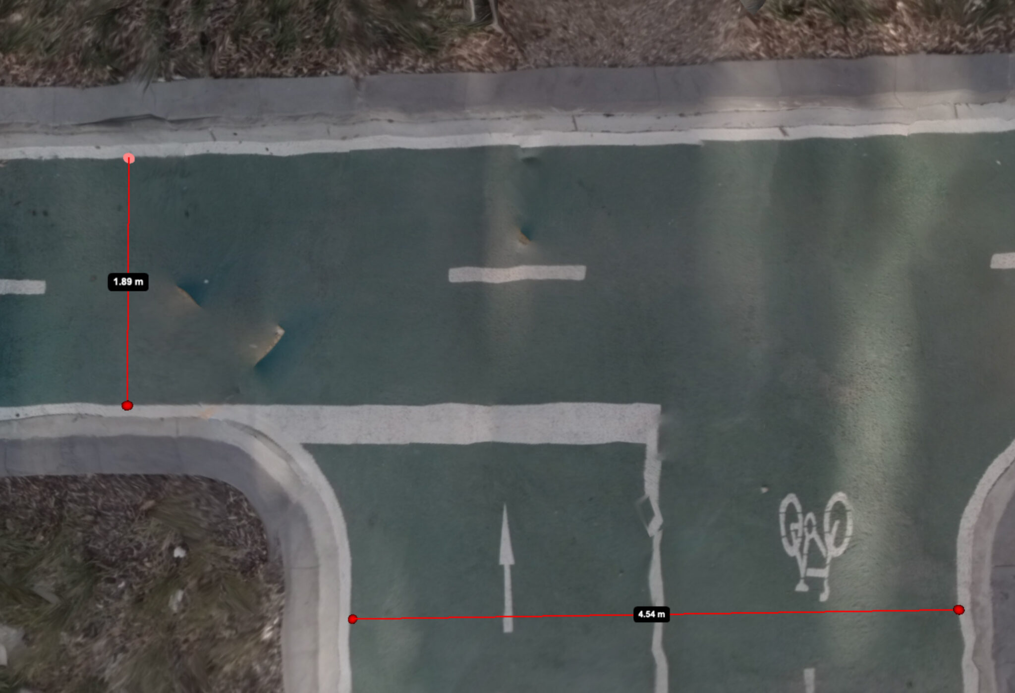
Generated aerial image of a bike lanes with digital distance measurements

Image Source: Jake Coppinger

Companies like Mapillary and Kartaview have played a significant role in advancing OpenStreetMap (OSM) and enabling detailed mapping efforts, particularly in urban areas. While 360° street-level images have been crucial for capturing high-quality data, there is a growing need for a scalable solution that leverages the power of aerial imagery to further enhance community mapping. In this blog post, we delve into the potential of aerial imaging and its implications for OSM mapping. Interestingly, emerging companies in the 360° imagery space, such as Mapillio (Commercial) and GeoViso (Open Source), may view this as an opportunity to add a unique selling point to their portfolio. The process of generating detailed aerial-like imagery for specific smaller areas not only benefits OSM mapping but also proves highly valuable for city planners involved in intersection redesigns or the addition of bike paths to streets.

See full entry

Posted by Mapping_Madison on 23 June 2023 in English.

I am now going to start working In Franklin Township. Hopefully I can finish at least the Forests, Farmlands, Cities, and possibly some more rural residential areas.

I will start in Chilo, and work my way across the Ohio River. once finished, I will then move along the borders of Franklin Township and I will finish Felicity. After that, I will work on the forests and farms in between Felicity and the borders of the Township.

Chilo will be tackled after I finish the forests and farmlands near it, and this will probably take a couple more edits, not too many though, hopefully.

June has always been a hectic month for the LGBT community as several PRIDE celebrations and rainbow-themed collaterals are all over the internet.

For this year, RainbOSM (a safe space for LGBT and allies on OpenStreetMap), MapBeks and the Open Mapping Hub Asia Pacific with HOT thought on casually collaborating in releasing some LGBT tagging information out of the closet (JK!).

This is essentially important as LGBT spaces and features are part of the real world and through OpenStreetMap we are able to digitally make them existent.

See full entry

Posted by mapmeld on 23 June 2023 in English.

Originally posted on https://blog.georeactor.com

I had the idea to go bike touring on the western tip of Lake Superior. There’s a lot to say, but I wanted to have an OpenStreetMap mapper + bike travelogue perspective first.

The Route

I started in Duluth, Minnesota and crossed the bridge into Wisconsin. The next day I started biking along the Tri-County Trail, through a forested area, toward Ashland, Wisconsin.

The Twin Ports

Duluth, MN and Superior, WI (combined population: 113k) are a center for rail and Great Lakes shipping. They were built up during lumber and copper booms around 1900. I arrived on the weekend of their biggest summer event (Grandma’s Marathon).

The Duluth Airport is served by a regional transit bus. On weekdays it’s Route 1 to a transit center, but on the weekend it was Route 5 to a more southwestern neighborhood. I updated the bus stop and surrounding waiting area on OSM.

Duluth has a couple of bike shops - major props to Ski Hut for their help :)

A good stretch of Superior Street has a protected bi-directional bike lane:

See full entry

Location: Town of Iron River, Bayfield County, Wisconsin, 54847, United States
Posted by InfosReseaux on 22 June 2023 in English. Last updated on 17 January 2026.

Hello everybody

OSM Tagging model is a unique piece of knowledge and its usage could be discussed more widely, even outside of OSM.
Recent announcement of Overture Maps Foundation data schema will challenge us shortly. I’ve been involved in tagging improvement for more than 10 years and I now believe a lot in its more general usefulness, even outside of OSM.
It’s time to find how making it obvious.

First of all, tagging is a core component of OSM project and will remain as this in the future, the point isn’t to split mapping and tagging apart.
However, our tagging model could inspire (or already inspires actually) many data managers operating data bases outside of OSM.
A lack of consistency, versatility and even relevancy are sometimes noted about many data sets we can be using in general. They are at least missing some uniformity while some of them describe the exact same objects despite coming from different producers.

The more we have data, the more we need to standardize their structures.
OSM actually have the advantage to be built over a single namespace and force contributors to maintain consistency between very different concepts. It’s not an usual practice, there isn’t so much databases that gather buildings, roads, trees and utility networks in the same place.
Time spent to document tagging is now a significant force to make our semantics usable even outside of OSM.
It’s not necessary to import private databases in OSM nor use OSM tools to get benefit from usage of provided tagging, if applicable.
Developing tagging is not necessarily a call to mapping or an attempt to make a given contribution mandatory. It’s also an exercise which demonstrates every day the versatility of OSM semantics and creativity of involved contributors.

In France, we already began to build strategic bridges between OSM tagging and business standards or government standards in order to make things interoperable.

See full entry

For some months now, Champs-Libres is working for NMBS/SNCB, the national railway company of Belgium, for reusing OSM data from Belgian stations. NMBS/SNCB has an interest in OSM data for improving some services to travelers regarding accessibility data, and especially for bicycles. Have a look at the wiki page for more insights!

The first diary entry was about the basic data about the Belgian stations and platforms and the second diary entry was about mapping access (steps, elevators, bicycle ramps, etc.) to the railway platforms. Here, we’ll deep into more advanced mapping of railway and access objects by looking at the “level” tag.

Why the “level” tag is important

Stations are most of the time built on several levels. Even small rural stations often have an underground passage or a bridge above the tracks to cross the railways. Whenever you have levels in a railway station, the level=* tag should be added on most of the objects. This is needed for several reasons:

See full entry

Location: Bomel, Namur, Wallonia, 5000, Belgium

TL;DR

Watch https://peertube.openstreetmap.fr/w/56SduK2wYnnUesnSroucbd


I have one nice way of finding best routes for bike rides. It is a mix of BRouter and Strava heatmaps. Whenever I show this to someone, they think it is really cool, but I never shared it with a world. Finally I found time to record my process. You only need Strava account and web browser to create these routes. I still think it is the best way to explore routes on desktop, but let me know if you can beat this:)

15 min video with subtitles is here: https://peertube.openstreetmap.fr/w/56SduK2wYnnUesnSroucbd

Thanks for checking it out!

Posted by Friendly_Ghost on 18 June 2023 in English. Last updated on 23 June 2023.

After I came across some business descriptions in OSM that were of dubious quality, I decided to hunt them down systematically. OSM is, after all, not a place for advertisements. Now, about half a year and hundreds of POI tag fixes later, it is time to reflect on this project and to share my observations.

Introduction

People who map their business on OSM usually have a single changeset in which they put their business on their map. They often foul up the opening hours sysntax and international formatting for phone numbers, and there is usually a lot of info still missing. This is fine, since OSM data in general follows the trend where basic map data receives details, corrections and improvements by different mappers over time.

An issue arises when companies try to sneak in their brochure texts and other SEO spam. We want OSM to stay objective and neutral and we want data that relates to the real world, so this information is unwelcome. We can’t stop people from mapping their company details, but moderation is clearly needed if we are to uphold these principles.

I started looking for a way to detect the unwanted spam. The result is this Overpass query for buzzwords in the description tag. Think about words like “award winning”, “reliable service” and “conveniently located”. This is a dynamic process, because I regularly add new buzzwords that I encounter alongside the ones that I find through the query and I remove words that result in false positives.

See full entry

Today, at 43 years old, I decided to start a blog to note down memorable experiences while mapping.

So this is about a spring day two months ago when I mapped this set of bicycle lockers: osm.org/way/82447313

They are located right next to the station in the Czech town of Melnik. They caught my attention when we were waiting for the train that was to take us into Prague. They work like this: You push your bicycle in, drop a small returnable deposit into the slot and that’s your bicycle safely stored for the day.

I could not help comparing them to the bicycle lockers next to the station of Wolfsburg, Germany, where I live. These work like this: You walk up to the operator’s office during their opening hours, sign a contract, pay a fee of 60€ (that’s for a year, but there are no shorter periods available).

I didn’t map anything else that day but there was also a nice public transport experience. At the end of our day trip to Prague we took the bus back from Ladvi to Melnik. It was during afternoon rush hour, so traffic moved slowly between the tower blocks. The bus was quite full, and after a day of sightseeing it already felt a little strange to sit as a tourist between locals going home from work. But when the long-haired bus driver turned up his radio as Queen played “Bohemian Rhapsody”, it felt as if we had been caught in an indie road movie by accident.

Another thing I like about Ladvi is that the green areas between the tower blocks are mapped as appropriate (garden/park/grass).

Location: Chloumek, Mělník, okres Mělník, Central Bohemian Region, Central Bohemia, 276 01, Czechia
Posted by Neelima Mohanty on 18 June 2023 in English. Last updated on 6 July 2023.

While everyone struggles , I chose to embrace the struggle.

Hello everyone, I am here again with the 2nd Blog of my journey as an Outreachy intern. For those who don’t know me , I am Neelima Mohanty , selected as an Outreachy intern at Humanitarian OpenStreetMap Team (HOTOSM) for the May to August Cohort. If you are new to my blog then make sure you read my Blog 1 before going through this blog post.

How many of you have come across new terms while contributing to open source communities? I guess everyone has . And do you remember how did you cope with it? As you think of all this , I will narrate you one such experience of mine during the contribution phase of Outreachy during March 2023 .

While raising a PR to add comments to the code of the osm-fieldwork repo as part of technical documentation , my mentor Rob Savoye reviewed it and said me that he liked the thought of adding comments to the code but it was not the right way. I would like to quote his words “Thanks for adding comments. We usually don’t need to comment write() and open(), as it’s obvious. If you want to get really deep into commenting source code, we want to add support for sphinx.This adds a comment block for each class and method. This would require you read and gain some understanding of the code itself, which is not a bad thing. We use sphinx for other python projects.”

See full entry