Diary Entries in English

Recent diary entries

Posted by valhikes on 18 January 2023 in English. Last updated on 19 January 2023.

I didn’t do any edits for the Water Canyon area, although I probably should. I wish some of the little trails were mapped, but I didn’t hike these. I couldn’t find anything about trails in the area before getting there and there are some.

I didn’t do much in the Ruby Mountains either. The trails seemed pretty well mapped. Hennen Canyon was totally missing, though. I therefore added it. It officially went all the way to the top of Ruby Dome! Some sort of trail still does, but there are variations. In fact, there are variations on down the canyon.

The Forest Service shows the trail further from the creek on the way to Griswold Lake and the trail that is getting the most use has a spot that is not very trail like near the top. I took a route further from the creek and found it better, even if not well used, on the way down.

I sure wish standard OSM would render the trail visibility and difficulty. It’s not right that absolutely everything is a bunch of red dots. This trail is not for just anyone with some sneakers.

I also added some details around the Right Fork since the public doesn’t get to start hiking where the road ends. I marked the parking and trailhead and sign so now that’s clearer. Also marked trailhead parking within Thomas Canyon Campground for Thomas Canyon since, again, you can’t park right next to the trail.

Location: Elko County, Nevada, United States
Posted by valhikes on 18 January 2023 in English. Last updated on 19 January 2023.

This one should actually have got noted before Lassen. Gray Falls is not a very big area, but there were no trails and the picnic area and toilet were missing and the road heads off to the long gone bridge even though it doesn’t quite. I added in the trails as best I could along with the amenities.

Location: Trinity County, California, United States
Posted by valhikes on 18 January 2023 in English. Last updated on 19 January 2023.

I started off the latest bit of mapping with some edits in the Community Forest. The Arcata Ridge Trail is finally done! But the land manager didn’t go and put the new trail on the map. Land managers, why don’t you do this? There were some other little things to deal with.

Then I stepped back in time to the Lassen area, where I hiked a big loop with the PCT and Hat Creek. There’s a lovely and well used trail along Hat Creek, but it wasn’t mapped at all. It’s all better now. I connected the PCT to Hat Creek via a trail that is, as it turns out, only mostly there. The bottom is seeing driving traffic. (Illegal, this is not on the MVUM.) The top is without clue except for a gate in a fence maybe a quarter mile down. In between it becomes animal trail, then obvious enough until a jeep track. (Legal to drive, it is on the MVUM.) It vanished a moment again, but probably due to me going the wrong way. It was really clear lower down. So I added that in with appropriate visibility noted.

The other end I connected via the Subway Cave. I decided not to add the trail the Forest Service had claimed was there. There’s trail around the campground, but not to the cave, and there’s other ways to get there.

I also hiked some of Bizz Johnson. It was missing the (official) bypass trails for the tunnels. The Southside Trail was missing an overlook loop and a connector. It’s also missing a river access and a second route for another overlook, but I didn’t hike those and don’t know where to put them exactly. The other direction was missing trail under the highway. There’s a relation marking it across the highway and that isn’t really how it goes. That is how the old grade went (but there wasn’t a highway then).

Location: Shasta County, California, United States

In the past, I’ve only mapped the part of my large outings that specifically stood out as needing it when I got to the end. It means I haven’t mined the full potential of map updates possible based on my travels. However, after hiking the West Elk Wilderness, I was determined that I really should sort through every track and create improvements. New philosophy: The more I add, the more likely someone else will decide OSM is useful, except it needs some help here, and start adding too. Actually an old philosophy, but I’m trying to implement it more completely.

So what happened in West Elk?

I hike using a combination of maps. When I’m in a National Forest, I can use the georeferenced PDF files the Forest Service publishes. These are the new vector based national map (USGS) with FS data superimposed. They are supplied in 7.5” quadrants by the same names as the older USGS maps. I point OruxMaps at a folder of folders of all the maps for a degree square and it picks out the right one for the location I’m looking at and presents it. It’s a very nice system, but the quality of the data varies by forest and even by ranger district. Sometimes it’s a little off, sometimes a lot. It’s nice to have a second opinion. It’s also nice to have something that covers outside the forest. For that, I have Open Street Map, which I can take with me via the files at Open Andro Maps. These are supplied by state and I have all of them downloaded and try to update states I know I’ll visit before going. The accuracy of these varies by all sorts of things.

In West Elk, a number of trails are faint and the general nature of the FS to be only mostly in the right place became a problem. Additionally, there’s a few alternate routes that didn’t exist on the ground. OSM had everything that was real, even if faint, and was missing those trails that didn’t have so much as a cairn to mark them. It seemed to be right on.

See full entry

Location: Gunnison County, Colorado, United States
Posted by b-unicycling on 18 January 2023 in English.

I’ve been looking at tumuli the last couple of days. In Ireland, they’re usually called barrows, but according to Wikipedia, it’s the same. So I went and tidied tagging in some of the features tagged as barrows (mostly site_type=ring-barrow/round_barrow and archaeological_site=ring-barrow/round_barrow etc).

I’ve also added that very important information to the wiki and created a table of the most commonly used tags related to tumuli/ barrows.

I noticed some possible duplicates in the tagging: I would think that round_barrow and round_tomb are the same, for example. Some of the tumuli tagged as mound probably fall into that category as well.

This morning, I started drawing some of the types and uploading them to WikiCommons (all as CC0), mostly after photographs I found online, because there didn’t seem to be any diagrams of the different types on WikiCommons. Most of them are just rough schematics (I say rough, it took me forever to draw every single stone), but one is actually a specific keyhole tomb in Algeria (there are hundreds mapped in Algeria!):

See full entry

Relatório de Atividades da UMBRAOSM em 2022.

UMBRAOSM Activity Report Year 2022 – Brazil

UMBRAOSM Activity Report

Year 2022 – Brazil

UMBRAOSM – Union of Brazilian Openstreetmap Mappers It was born from the need to improve the openstreetmap data and not only improve the data but also to create events for the Brazilian community such as mapathons, validathons and work-shops to train Brazilian and foreign mappers for a better quali-ty of the data that are mapped in openstreetmap making with that the openstreetmap database has a good quality and with that it is a reference for other countries for having qualified mappers for a good mapping.

See full entry

There is always a milestone waiting for everyone, and one of them was meant for me. A voyage that taught me several tools that can be used for validation and some that would help with mapping. We also had a lot more sessions with aerial images, mobile data collection apps, and other things.

Pre-Journey of DQI:

It was a lovely sensation to be noticed and called for the intern interview. Ralph and Becky were there to guide us. I couldn’t believe it till the mail arrived informing me of my selection and subsequent processing. From a total of 1008 applications from 81 different countries, representing the country of highest peak was an incredible achievement that I could never have imagined. We had a kickoff for the internship after a week or two, and I had an amazing voyage of friendship, professionalism, passion, and future.

Journey of HOT_DQI_2022

The three months’ journey with fellows from different nations was quite interesting. A bit of their languages, their culture, tradition, their mapping career and other opinions were magical and all these were possible because of the ‘Coffee Chat Session’ we had together.

Week 1 and 2

The week included basic and advanced ID Editor and JOSM training with numerous plugins, which has actually helped me with quality mapping and a bit faster mapping. The most intriguing thing I learned was about OpenCycleMap, multipolygons, and tall building mapping. I’m still surprised at the mapping of the tall buildings. I had a hunch I was a mapper, but there were many holes in my knowledge, and now that I’ve started learning about mapping from the first week, I am feeling a bit confident about mapping. The most important session was with Samson who walked us with the effective session of Top 10 Data Quality Aspects. We were so much excited for the further weeks to come.

Week 3

See full entry

Location: Chabahil, Kathmandu-07, Kathmandu Metropolitan City, Kathmandu, Bagamati Province, 44660, Nepal
Posted by Harry Wood on 17 January 2023 in English.

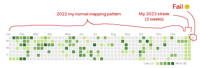
At the new year I had the crazy idea to go for a 2023 OpenStreetMap Editing streak (Try to do at least one edit every day). I knew I wouldn’t manage to go the whole year, but once you start doing these things on January 1st, you feel compelled to carry on.

But I only managed… two weeks

How Did You Contribute tool

This is a screenshot of part of the “How Did You Contribute” tool. Designed to look like github’s profile section for showing off your contributions (Lots of other neat facts and figures besides that on that tool).

See full entry

Posted by Akrimullah on 16 January 2023 in English.

The 21st to 25th of November was the peak of my OSM journey in 2022. I was selected as one of the SOTMA Scholars to attend the event in Legazpi, Philippines. HOT Asia Pacific HUB was the one who invited me. From Indonesia, Zainab was also selected along with me and the other scholars that came from Nepal, Sri Lanka, Vietnam, Pakistan, India, Bangladesh, and Timor Leste.

This was actually my first time visiting the Philippines. I enjoyed so much stay in Legazpi. We visited the Mayon Volcano, tried various local culinary, and played amazing race games aside from attending many choices of talks and workshops at Bicol University (the venue where SOTMA 2022 was held)

Mayon Mountain

It was wonderful to meet with the OSM community in Asia. We shared a lot of experiences, stories, and meaningful OSM journeys as that one is the one why we were at the event. I always remember every detail of the discussion I have made with almost all of the participants in the SOTMA 2022.

See full entry

Location: Paledang, Bogor Tengah, Bogor, Java, 16122, Indonesia
Posted by SomeoneElse on 16 January 2023 in English.

Just after the New Year, there were a few reports of people getting stuck and having to be rescued while hiking in the English Lake District.

There are writeups of this in “The Great Outdoors” magazine here and on Alex Roddie’s blog here. They really are worth reading - the consensus on IRC, Mastodon etc. was that the quality of the article was streets ahead of what you might expect to see in the generalist national press.

Lots has been written about how map and app developers can try and convey information to a user beyond “this is a way of getting from A to B” (including an OSM diary entry that I wrote in December 2022), so I won’t go over that again.

However, one particular quote from the Great Outdoors article did stand out for me, and it’s this:

A spokesperson for Keswick Mountain Rescue Team, which carried out the rescues, said: “There is no path via this route – only a scramble of loose scree which also requires the walker to negotiate the rocky outcrop of Slape Crag. It’s the scene of previous callouts.”

The reason why that stood out is that “path” can mean different things to different people:

  • an actual signed path suggesting that people on foot are encouraged to go via a particular route. In England and Wales there’s the concept of “public footpaths” (and public bridleways), which is a legal right of foot (and horse) access across what might be otherwise private land.

  • some indication on the ground that people often go via a particular route

Often the two coincide, and “where you’re supposed to go” matches “where people do actually go” correspond. Sometimes, however they don’t.

See full entry

Location: Old Kiln, Helmsley, North Yorkshire, York and North Yorkshire, England, YO62 5HL, United Kingdom
Posted by gnesss on 15 January 2023 in English.

Fifteen days in

Fifteen days into the year and the first UK quarterly project of 2023.

I’m quite encouraged by the early progress we’ve made on notes. As noted in the wiki page, there were just over 30,000 open notes at the start of the year. Right now that figure is 29,327. About 700 new notes have also been opened in that time, so that’s around 1500 notes closed already!

My own mapping efforts comes in peaks and troughs like I suspect many of ours do. Personally I’ve found this project quite fun. An open note can motivate me to help update the map as it gets me looking at the sources available whilst addressing the issue in the note.

So far my preferred way of browsing notes is using ResultMaps by Pascal Neis.

Types of notes

A few types of notes I’ve seen.

Nonsense, or notes used for non-mapping purposes

A fair few notes are clearly non-mappers who dropped a note on the map to share where they were planning to meet up, where they found random stuff or were otherwise planning work. Clusters of notes such as ‘Site Location’ ‘This is the place’ could be found in some cities, or ‘fungi?’ up a hill side.

Stuff that is already mapped

Many notes are highlighting new amenities, houses, roads, etc. These are then found to have been mapped since but the note not closed. An easy win for this project.

Partial info

A note that just says ‘closed’ or ‘paths missing’ is a good cue but would be much easier if it includes the business name that might have closed, or the vector of the missing paths at least - particularly in areas where some paths are already mapped. Or worse, a note that just says ‘Name changed’ with little indication of what was the old name, let alone the new one.

Street Complete generated

See full entry

Location: Brownsover, Newton, Rugby, Warwickshire, England, CV21 1LT, United Kingdom

In 2022, I had the big privilege to join the Humanitarian OpenStreetMap team for the southern and Eastern Africa Hub in Zambia as a volunteer. My experience can not be explained on one plain paper or page. I have received more skills than I expected and overwhelming lessons. In fact, I am not geospatial by profession but a records and archivist manager. I have learned all my spatial life off my profession through the help of #YouthMappers #Crowd2MapTanzania and #HOT. In addition, today I can simply say I am an expert in the Geospatial spectrum and I do train massive of people in this field. I have no paper but the skills and knowledge that i have acquired directing through networking, collaboration, and Mapathons. Lastly, i have done a lot of self-development to ensure that at least I make sure i do something daily in spatial and open mapping areas. Contact info charlesmchilufya@gmail.com +260962256767 (calls and WhatsApp).

Posted by soya666 on 13 January 2023 in English.

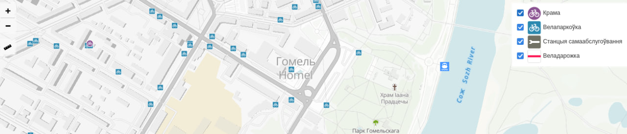
map of bicycle infrastructure

At the end of 2021, I had an idea to collect missing bicycle infrastructure data in Homieĺ (Bielaruś), then visualize and generate statistics. Thus began a project called Bicycle Homiel.

Projects Stages

  • Collecting and adding missing data to OpenStreetMap: both missing objects and characteristics of objects
  • Export data into a PostgreSQL database
  • Calculation of general statistics with SQL, calculation of statistics by districts with PostGIS
  • Export geodata into GeoJSON; export statistics into JSON
  • Uploading geodata and statistics to the website

Point objects (parking, shop, repair station) were collected using Every Door. Cycleways were photographed, and then missing data were added using JOSM.

And while cycleways were generally fine, most of the shops, parking lots, and repair station were missing in OSM.

Statistics

As of 13.01.2023 OpenStreetMap has 629 bicycle parking, 17 km of cycleways, 14 bicycle shops, and 4 bicycle repair stations in Homieĺ.

See full entry

Location: Мельнікаў Луг, Цэнтральны раён, Homyel, Homyel Region, 246006, Belarus
Posted by krschap on 13 January 2023 in English.

Hi all ! I want to share the information about that I have created two OpenStreetMap Bot on Twitter

  1. Open Street Map Retweet Bot

https://twitter.com/OSM_retweet_bot

This Bot is created to follow the recent trends on OSM, What people are thinking or doing in OSM, This bot will try to retweet the tweets with hashtags : #osm, #openstreetmap and #hotosm, Runs every three hour

  1. Open Street Map Stats Bot

https://twitter.com/stats_osm

This Bot is an implementation of standalone open source tool called OSMSG https://github.com/kshitijrajsharma/OSMSG, This tool uses osmium to analyze the change files from OSM using different URLs and generates the stats in different file formats such as CSV, JSON, image etc. It has a GitHub action enabled which will run the stats for requested region and global and produces the stats in CSV and image format and shares it with the twitter community, You can follow the GitHub tool itself to see / download the stats. I have added Nepal as monitoring country, but if you want any other countries, you can request it via opening an issue or mentioning bot to twitter. https://github.com/kshitijrajsharma/OSMSG/tree/master/stats Since it uses GitHub, you can also go through the historical stats using GitHub history it will keep updating the same file when it runs and shares the link in twitter

Both projects are open source and beta release, I will be looking for the recommendations and improvements on future ! Thank you !

Posted by b-unicycling on 11 January 2023 in English.

I was going to do some more field name surveying next week, but shock, horror, it is no longer possible to “make an atlas” on fieldpapers.org.

error message fieldpapers

DeBigC and I have tried to find out why. There was a post on GitHub, even before I noticed it, but no reply. DeBigC was more successful on Reddit, where the reason is given as having run out of funding.

This really is a shame; it was such a useful tool. Maybe there is a way to bring it back?

EDIT 11-01-2023 21:41: It’s back working again, very strange.

Posted by pnorman on 11 January 2023 in English.

Dear all,

Today, v5.7.0 of the OpenStreetMap Carto stylesheet (the default stylesheet on the OSM website) has been released. Once changes are deployed on openstreetmap.org it will take couple of days before all tiles show the new rendering.

Changes include - Unpaved roads are now indicated on the map (#3399)

  • Country label placement improved, particularly for countries in the north (#4616)

  • Added elevation to wilderness huts (#4648)

  • New index for low-zoom performance (#4617)

  • Added a script to switch between script variations for CJK languages (#4707)

  • Ordering fixes for piers (#4703)

  • Numerous CI improvements

Thanks to all the contributors for this release, including wyskoj, tjur0, depth221, SlowMo24, altilunium, and cklein05, all new contributors.

For a full list of commits, see https://github.com/gravitystorm/openstreetmap-carto/compare/v5.6.2…v5.7.0

As always, we welcome any bug reports at https://github.com/gravitystorm/openstreetmap-carto/issues

Posted by ZeLonewolf on 10 January 2023 in English. Last updated on 11 January 2023.

The Americana vector style uses OpenMapTiles as its backing data schema. When the project desires to add a new feature that isn’t available in OpenMapTiles, someone from the team typically submits a PR to add it. Eventually, OpenMapTiles will create a release, which gets picked up by the Planetiler OpenMapTiles profile, after which I would re-render the planet on an AWS instance. This process from end-to-end often takes months before we see the results at planet scale.

Because planetiler’s update cycle follows OpenMapTiles, contributors need to use the older openmaptiles-tools, which can take days, weeks, or even months to render a planet, depending on how powerful the developer’s computer is.

Therefore, when testing a change to OpenMapTiles, a contributor would typically test their changes on a small area, with a command like:

./quickstart.sh rhode-island

This command would download a PBF extract from Geofabrik, and run a series of scripts that ultimately produce an .mbtiles file of Rhode Island. If you’re testing a feature that appears at high zoom, you can edit .env and change the setting to render down to the maximum zoom of 14. Because Rhode Island is so small, a full-depth render only takes a few minutes.

However, what if you are testing a low zoom feature like an ocean or sea label? If you need to test whether the Atlantic Ocean label is rendering properly, there is no extract short of the planet that will contain an ocean.

The solution for developers working with these features is to download the planet file, and then pre-filter it using the tags-filter feature in osmium tool for just the features that you care about testing at low zoom, and then render that into tiles.

First, you download the planet pbf file:

AREA=planet make download

This will download a file planet.osm.pbf into the data/ folder.

See full entry

Location: 61.418, 20.566