Diary Entries in English

Recent diary entries

Posted by Supath Dhital on 18 November 2022 in English.

Background

Passionate on earth science and open data and that courage and motive burst my enthusiasm and help me to enroll Bachelors of Geomatics Engineering just after my +2 level. I find this university academic course more interesting than i expected before. Firstly I got to know about the OSM when i was in the first semester of my engineering life through the campus Organization and attend my first ever session on OSM and find it was so interesting. At that time due insufficient network and lack of own knowledge i only start OSM continuing mapping since 2021 but introduced about OSM was since 2019. After engaging so many volunteering work and webinars, mapathons and training sessions, i got chance to do different project at KLL and guidance from the professional mapper helps me a lot to sharp my skills and i am getting more and more interested to mapping.

Later on, I joined Data Quality Intern at HOT from Oct 2022 for 3 months and this is really helping to find better way of controlling data quality and QA tools and so many.

Location: Arpana hatchary and agro farm, Pokhara-16, Pokhara, Kaski, Gandaki Province, 60600, Nepal
Posted by LySioS on 17 November 2022 in English.

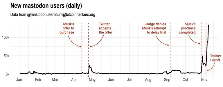
Surely, you’ve heard Elon Musk is trying to save / sabotage Twitter (choose the correct answer).

It led a bunch of people to flee from Twitter and discover Mastodon.

Never heard of Matodon ? “Mastodon is free and open-source software for running self-hosted social networking services. It has microblogging features similar to the Twitter service” says Wikipedia.

more info


Amanda from the OSMF is running her own instance called (https://en.osm.town/). She’s looking (threatening?) for a logo.

We need your creativity !

Below, my proposals :

See full entry

Posted by ryztrk on 17 November 2022 in English.

Open source culture is increasing day by day in Turkey. In this way, many platforms and associations have been established in the field of open source and data. Many of them organize events, workshops and studies in their field. Websites or social media accounts have been added to reach them. If there is an association, organization or platform you would like to be added to, please get in touch. (It is constantly updated.) Open Source

Yer Çizenler Mapping for Everyone

Openstreetmap Türkiye Telegram Channel

Openstreetmap Türkiye Facebook

WeeklyOSM TR

Turkey Open Source Platform

Free Software Association

Wikimedia Turkey

Open Data and Technology Association

Posted by JaphetMasunzu on 17 November 2022 in English.

Introduction

My name is Japhet Masunzu from the Democratic Republic of Congo

What i like

  • Christian music

  • mapping

  • Eating rice and beans

Lien osm.org/user/JaphetMasunzu/diary

HOT Data Quality Internship 2022

HOT Data Quality Internship 2022 is a good HOT program for which we had the privilege to be selected, in order to increase our knowledge about openstreetmap data validation and quality control tools. It is really a good time of training and information very profitable.

Location: Butembo, Kimeni, Butembo, North Kivu, Democratic Republic of the Congo

Brazilian Mapper asks for donation to continue his full-time mapping work. Brazil

website for donation: https://opencollective.com/playzinhoagro

Preciso da sua ajuda: Como você pode ajudar a apoiar meu trabalho Criada por PlayzinhoAgro a 10 setembro 2022 em Portuguese (Português) English Version

Nesses últimos 2 anos como voluntário em tempo integral desenvolvi vários projetos de mapeamento pelo Brasil, por acreditar ser meu dever contribuir por conta do deficit que o mapa tinha na minha região. Minha meta como mapeador é tentar diminuir os espaços em branco no OpenStreetMap para que mais pessoas possam usá-los e assim mais mapeadores surgirem.

Entendo que nem todo mundo tem tempo ou interesse em mapear, no máximo fica no básico e muitas vezes acaba esquecendo do OSM por não consegui usar no seu dia a dia, ainda mais em um país como o Brasil onde dificilmente um trabalhador teria tempo para ficar atualizando mapas.

Tenho me dedicado diariamente ao OSM, mas infelizmente isso tem um custo e já que não sou nenhum herdeiro, tem sido bem difícil conciliar meu trabalho como voluntário e minha vida pessoal, já passei por fases muito complicadas desde que eu decidi me dedicar em tempo integral, mas também tive muitas ajudas.

Trabalhar no OSM não é uma tarefa fácil, pois seu trabalho nunca está concluído, sempre há novas mudanças que precisam ser mapeadas, erros a serem corrigidos, é um trabalho contínuo que exige certo nível de conhecimento e experiencia adquirida com o tempo.

Um dos primeiros projetos que eu fiz foi usando o DAMN e depois o Taskmanger para poder gerenciar e mapear cidades inteiras, com esse projeto foram quase 20 cidades que foram totalmente mapeadas desde as estradas aos edifícios.

See full entry

I guess I didn’t keep up with this diary. I’ve been busy since that first entry.

I’ve gone through both Cleveland National Forest and San Bernardino National Forest to fill in and tag forest roads and trails. At this point, both forests should have all of the official routes of travel with their official names and refs. There will be some differences between OSM and the FS Topo data source where conditions on the ground are different from what USFS has in their data set.

I also worked with a team of mappers to update all the Sq___ names that were changed by BGN/USGS in both OSM and Wikidata. (See https://www.doi.gov/pressreleases/interior-department-completes-removal-sq-federal-use and https://edits.nationalmap.gov/apps/gaz-domestic/public/all-official-sq-names.) That made me really happy because the unfortunately named local “Squaw Tit” that I used in my backcountry navigation course is now appropriately named “Mat Kwa’Kurr.”

I have two things going on now. I’m filling in the roads that CBP has made in the Jacumba Wilderness Area. There’s been a lot of activity out there recently and some construction work on two new border wall segments. This activity is controversial for a number of reasons, so I think it’s important to document the impact CBP has had in the area.

I’ve also started working with the BLM Ground Transportation Linear Features data set to fill in backcountry routes in SoCal.

I’m starting with the area around Superstition Mountain in Imperial County because it’s a popular area for off-road activities. The terrain there makes navigation challenging, so good maps can make a huge difference.

Unfortunately, the shifting sand dunes in the area also make mapping difficult. And the BLM data is not very good. The BLM tracks wander off into places where there are no tracks on the ground. And the BLM tracks take some improbably dangerous routes over surface features, like crossing the sharp crest of a soft sand dune.

See full entry

Location: Imperial County, California, United States

Projeto pensando pelo mapeador PlayzinhoAgro - Brasil

osm.org/user/PlayzinhoAgro/diary/397900 e Apoiado Pela UMBRAOSM - União dos Mapeadores Brasileiros do Openstreetmap.

Project thinking for mapeador PlayzinhoAgro - Brazil.

osm.org/user/PlayzinhoAgro/diary/397900 and Supported by UMBRAOSM - Union of Brazilian Mappers of Openstreetmap.

Reimaginando o perfil de usuário do OSM

Reimagining the OSM User Profile

I would like to start by explaining that this is an exercise in imagination on how we could improve the UX/UI in the OSM profile, this means that some changes were based on my experience and there are still some things missing that I have not explored, like the Diaries, settings and Messages, I would love to get feedbacks from you!!!

See full entry

Posted by skfd on 13 November 2022 in English.
Location: Águas Férreas, Figueiroa, Lapa, Cedofeita, Cedofeita, Santo Ildefonso, Sé, Miragaia, São Nicolau e Vitória, Porto, 4050-021, Portugal
Posted by mvexel on 13 November 2022 in English.

I am terrible at keeping journals, and this will probably be no exception, but I have been enjoying some folks’ regular updates about what they have been up to in the OpenStreetMap world. So let’s give this a try! Two weeks late already for October; life got in the way..

Mapping

I’ve had a pretty active mapping month, but also all over the place, more so than usual.

  • I participated in a virtual mapping party at work. We worked on a HOT Tasking Manager project. This is the first time in a while that I had really worked with Tasking Manager. It’s generally easy to use but sometimes the instructions can be clearer. It was good to get out of my mapping ‘comfort zone’.
  • I did my usual surveying while out and about using GoMap!! while the weather is still nice.
  • I read somewhere that Geofabrik’s OSM Inspector had gotten an update with some new categories, so I gave that a new try. I ended up spending quite a bit of time untangling some invalid polygons.
  • Used RapiD to add some government-provided GIS data. I also wrote about this, see below.

Meeting

  • We had our monthly OpenStreetMap Utah meetup and it was a special and fun one! I decided I wanted to try out Every Door, the mobile POI and micromapping app. We went to a local mall and I wrote about it. We will do this again!

See full entry

This is my first attempt on the subject of the title divided in 6 topics. Sorry for the long text (but could be far longer).

Disclaimer: low experience as OSM mapper!

While I do have prior advanced experience in other areas, as you can see from my account, I’m so new to the project that as a newbie user of iD left after the tutorial in India I got scared that if someone touches something, after that validators will assume that person is responsible for errors in that something. In my case it was “Mapbox: Fictional mapping” from OSMCha.

So assume that this text is written by someone who one day ignored iD warnings for something I touched, still not sure how to fix the changeset 127073124 😐

Some parts of this post, such as reference to notability (from this discussion here osm.wiki/Talk:Wiki#Use_Wikibase_to_document_OSM_software) and gives some hints of unexplored potential which not even current OpenStreetMap Data items are doing (from this discussion here Remove Wikibase extension from all OSM wikis #764) are the reason for the dismistifing part of the title.

1. Differences in notability of Wikidata, Wikipedia, and Commons make what is acceptable different in each project

I tried to find how OpenStreetMap defines notability, but the closest I found was this:

For sake of this post:

What I discovered is that Commons already is used as a suggested place to host for example images, in particular what would go on the OpenStreetMap Wiki.

Wikipedia is likely to be far more well known than Wikidata and (I suppose) people know that Wikipedias tend to be quite strict on what goes there.

See full entry

Posted by Rick Rupp on 11 November 2022 in English.

I recently discovered that the county assessor has put a version of the parcel database online, searchable by a web map interface. Most of the parcel entries in the database have address information that can be entered into OSM.

My workflow is to use a split screen. On one side I have a browser window open to the assessor’s web map interface. On the other I have JOSM running. I use the address tool to manually fill in the information.

While Whitman County is a little larger than the state of Delaware in area, it only has a population of around 50,000. I plan to start with the small communities and rural areas of the county then progress to the city of Pullman.

Location: Colton, Whitman County, Washington, 99113, United States

This was my original question on the Wiki :

The OpenStreetMap Foundation ("OSMF") already had discussions and even a committee on takeover mitigation and this question focuses on this topic. The Humanitarian OpenStreetMap Team United States Inc ("HOTUSI"), which it's grow up over 100x OSMF budget (using 2020 as year, 26,562,141 USD vs 226,273 GBP), on its board minutes date 2022-01-24 (archived version here) already admitted interest on trademark agreement "with clear, irrevocable rights to the name" as option to "Ensure that the HOT Brand name is not in danger and is formerly in HOT’s hands", however this explicitly require OpenStreetMap Foundation approval at least once in its history. Already before this election, the new discourse community, which is public know have receive support from HOTUSI, had a paid HOTUSI employee closing a discussion about HOTUSI which also asked why the site redesign still being delayed to a point of know to not happens before the OpenStreetMap Foundation election, even if this already was asked on OSMF mail lists, and the incident sparked a discussion on handling conflict of interest on moderation channels. At this very moment of the history of OpenStreetMap, majority of candidates in this election do have links with HOTUSI, so it is viable that the result will allow a single corporation to make decisions in self interest against OSMF, in which you hopefully will win as a candidate. So the question to you is: how will you handle conflicts of interest in the OpenStreetMap Foundation board itself under this challenging context?

Regardless of this, I’m actually very okay with the set of official questions proposed for candidates to be asked to answer, since common themes were grouped. And the fact to point to the Trademark Policy was better than the ones I used to contextualize. Fantastic!

New absurd events

See full entry