Diary Entries in English

Recent diary entries

After you’ve been out dancing 💃 & drinking 🍸 at the club🪩, that take away joint open at 2am 🌆 suddenly looks very appealing 🍔🍟🍕. So for every night club in OSM, I calculated the distance to the nearest fast food take away. Here’s a map of where you have to go >20km for a take away:

map of the world

🗺️ explore this as a web map here

See full entry

Motivations

Have you ever wondered when on earth, you would have opportunity to meet in person, have a handshake, a hug, an off-screen smile, take a coffee or even a lunch together with friends and colleagues you have remotely worked with, as weeks, months and years keeps counting in a virtual world of OpenStreetMap global community? Yes, our trending techs and AI keeps offering us the best of smart connectivity with everyone in a digital space of daily online activities that builds around us a world of virtual communities with uncertainties, barriers and boundaries of never meeting physically in our life time. Have you ever, thought about, the uncertainties of meeting in person such cool guy as Geoffery kateregga and the rest of HOT and OSM Africa local community leaders after consistently working virtually in HOT working groups, OSM Africa Mapathon, Community meeting and the rest for weeks, months and years in a virtual world of OSM.

What about meeting your boss-Pete Masters the Head HOT Global community (of course, if you are a community leader or aspiring and being mentored to be one) after having series of community mentorship, supervision, and virtual meetings through WhatsApp zoom, jitsi and the rest of the virtual platform that makes you forget the distance barrier and that you never had an opportunity to meet in person. Infact, after meeting virtually for years gone by, it only dawned on me that my very boss-Pete Masters had such an intimidating height that would dare me stretching out my neck when I first met him on my arrival for SOTM2022, in Florence, Italy. So, my virtual assumptions were wrong after all, thanks to FOSS4G2022 and unSummit HOT.

See full entry

Location: Alakahia, Obio/Akpor, Rivers State, 500004, Nigeria

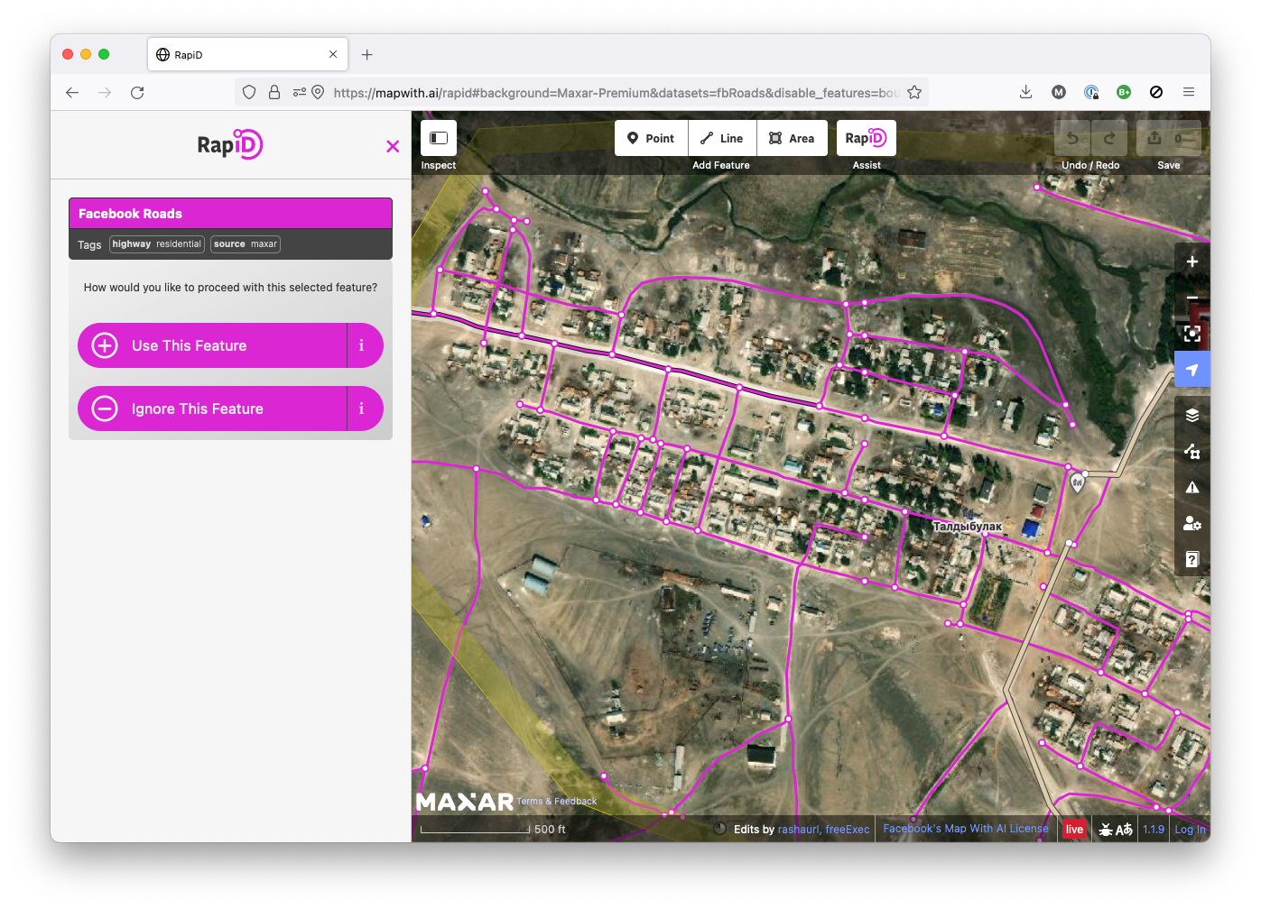
RapiD is an alternative to the OpenStreetMap iD editor that adds the ability to easily add data from approved external sources to OSM. Chances are that you—like me—know RapiD from the MapWithAI initiative, Facebook / Meta’s effort to publish road geometry derived from aerial imagery using machine learning. RapiD started out to support this effort; a fork of the iD OSM editor, RapiD added a layer to display the ML-detected road segments, and a nice user interface to add these segments to OSM, connecting them with the existing road network where possible.

rapid in ml roads mode

See full entry

Location: Central City, Salt Lake City, Salt Lake County, Utah, United States

I have been an active OSM mapper (and contributor to some HOT task mapping projects in different countries ) since 2013, mainly mapping based on satellite imagery. My main focus has been on Ethiopia, North Korea and DR Kongo.

At the moment (from March 2025 on) I try to map waterways and watersheds of the Ethiopian tributaries of the Blue Nile (called አባይ = ābayi/Abbay/Abbai in Amharic). A lot of theses waterways and the areas around them have been very poorly mapped yet. I have started with the river which is called Rahad (نهر الرهد) in Arabic and Shinfa (ሽንፋ ወንዝ) in Amharic.

The rivers in the Ethiopian highlands are of crucial importance for the cultivation of the land and the settlement structure - in a way which is unusual and often uknown for European people: The settlements are usually on top of the mountains (using the rain at the main water source) between the rivers, not at the rivers. A lot of the rivers and their ravines are blocking travelling and transport, not supporting it.

River Shinfa (ሽንፋ ወንዝ / نهر الرهد)

Relation of the main course of the river

Detailed Mapping Finished based on Esri Imagery
Downstream
River Shinfa - right tributary A
* about 10m wide at confluence, clear/dark water, meandering (SI = 1.84)
* so far mapped length 7.60 Km - E to W
* from 12°03’21.0’‘N 36°37’51.5’’ E to 12°03’54.6’‘N 36°35’39.0’’ E
* height: 1225 m to 1080 m (19.08 ‰ botton slope)

River Shinfa Section 1
* up to 30 m wide, ravines, light brown water, twisting (SI= 1.436)
* length 7.18 Km - SE to NW
* from 12°03’54.6’‘N 36°35’39.0’’ E to 12°05’33.5’‘N 36°33’28.1’’ E
* height: 1080m to 1000 m (11.14 ‰ botton slope)

River Shinfa - right tributary B
* 35m wide and more at confluence, light brown water, twisting (SI = 1.504)
* so far mapped length 21.39 Km - NE to SW
* from 12°08’39.8’‘N 36°40’37.9’’ E to 12°05’33.5’‘N 36°33’28.1’’ E
* height: 1200 m to 1000 m (9.35 ‰ botton slope)

See full entry

Location: North Gondar, Amhara Region, 6200, Ethiopia

Vincent Privat posted on twitter of a gun shop across the road from a bank. WeeklyOSM reported it in №634. So it got me thinking. 🤔 And hacking. 🙂👩🏻‍💻

I built a new tool osm-distance-to-nearest which calculates “how close the nearest X is for every Y?”. When you download the OSM Planet File (~70GiB!), and run this command, you’ll get a CSV file for every shop=weapons in OSM, with how far away the nearest bank or ATM is.

osm-distance-to-nearest -i ~/osm/data/planet.osm.pbf -b amenity=atm,bank -a shop=weapons -o p_guns_bank_

Vincent’s case is a weapons shop Armurerie du Vieux Bourg de Kourou (node 2,992,825,744) which is 60m from an ATM operated by La Banque Postale (node 3,022,885,288). at 5° 9′ 55.134″ N 52° 38′ 28.9788″ W in Kourou.

But there are more than 300 weapon shops within 60 metres of a bank or ATM! There are many weapon sells next door to a bank. This is so practical! 🤣🤣 Full formatted table is in this comments.

Posted by alexkemp on 23 September 2022 in English. Last updated on 14 October 2022.

Arthur Brown

Joseph Bazalgette is rightfully lauded as an accomplished Engineer & heroic in many actions, including in his role as chief engineer of London’s Metropolitan Board of Works, implementing gargantuan sewage works that will have saved millions of Londoner’s lives from the threats of cholera & other water-borne diseases. Few people will realise that there are many similar Victorian-era heroes within Nottingham’s history, and it is likely that even fewer people could name any of them.

Go to this diary entry for more info on any year quoted here.

Today’s diary will commemorate Nottingham’s Borough Surveyor and Engineer Arthur Brown, and underline his achievement in designing & building the 1884 Beck Valley Storm Water Culvert.

See full entry

Location: Mapperley, Nottingham, East Midlands, England, NG3 5QQ, United Kingdom
Posted by martien-176 on 21 September 2022 in English.

OSMCha (https://osmcha.org/) was down and i felt crippeled. This tool has become an essential part of my workflow lately.

So to be prepared for the next time OSMCha is not available i gathered some usefull alternatives (although less “luxurous” as the original).

Changeset level:

Node/way/relation level:

This is primarily a “note to self”.

But if someone has nice additions to this list, please add them in the comments.

Posted by Akinfasoye on 21 September 2022 in English.

I never anticipated such an awesome experience at the State of The Map 2022 conference in Firenze, probably because it was my first time. It felt like I was with a family basically because we all have one thing in common; Map. Meeting people from several fields utilizing the geospatial open data was mind blowing for me. I learnt a lot from professionals with advanced expertise in using OSM data in solving global problems. I would say that after this conference, my motivation to contribute to OSM took a drastic boost and this is evident in my recent engagement on the platform. I say a big thank you to Himmanitarian Open Street Map Team for awarding me a travel grant to attend the conference.

Location: Mitte, Berlin, Germany
Posted by mapmeld on 21 September 2022 in English.

I had planned to do monthly updates, but instead after a Europe trip, I returned home to a mostly-mapped Chicago and stopped editing so much.

Chicago

  • A local news article covered the Winthrop Family Historical Garden - a park marking the only block where Black Americans could live in Uptown in the 1920s. I added this to OpenStreetMap.

  • Following a Reddit comment, I added the pull-off area and path for a Schiller Woods water pump which attracts the superstitious. Google StreetView shows the area had cars going back many years.

  • My local park recently replaced a ‘desire path’ with a paved sidewalk, so I finally could add it to the map.

Las Vegas

I removed some OSM paths which made it look like you could enter the MGM Grand monorail station from the street level (you need to walk through the casino).

The new Caesar’s Forum conference center was well-marked with indoor mapping (restrooms , exits, etc. ) but the building did not appear shaded in on OSM. It’s unclear what was wrong, but I checked today and finally it’s appearing.

Border edits

I was inspired to resume editing areas along the Myanmar-Laos-China border. A lot of times there are marked residential areas or some little bubbles of roads which should be connected to the larger road network. Other times, as previously discussed, there are large tracts of new construction in part due to the Belt and Road Initiative. I found myself making a lot more edits, and occasionally stumbling on roads which I previously edited in summer 2020.

See full entry

Location: Near North Side, Chicago, North Chicago Township, Cook County, Illinois, United States
Posted by alexkemp on 20 September 2022 in English.

Time for a humiliating admission.

Year-dates below can be cross-referenced within my last diary-entry: Mapping Changing Street-Names in Nottingham City.

This was sparked by a visit to the Manuscripts & Special Collections (MSS) at the University of Nottingham on 6 July this year. I was conducting research into water & sewage history within St Ann’s and was there to research (what turned out to be) the 1883 Beck Valley Storm Water Culvert. That needs a diary entry all for itself, but today I need to stay on subject.

Mapping the culvert began on 15 September and, fortunately, began at the River Trent end (on Trent Lane). ‘Fortunate’ because, 5 years ago, will_p had mapped it and — my assumption — had found the culvert outflow nameplate and had both recorded and used it in his mapping.

So, mapping started at the southern, riverside edge of Trent Lane & continued northwards towards Bath Street, ending today as I reached The Wells Road, following what had been recorded in the MSS.

I was in great mood as I started, since I now had an official name for the culvert. That mood began to deteriorate as it continued. Roads were skew-whiff & houses off their centre. It seemed that earlier mappers had not used any imagery-offset corrections. I was fixing everything that I met as good as I could, but it was beginning to wear me down.

See full entry