Diary Entries in English

Recent diary entries

Posted by mapmeld on 21 September 2022 in English.

I had planned to do monthly updates, but instead after a Europe trip, I returned home to a mostly-mapped Chicago and stopped editing so much.

Chicago

  • A local news article covered the Winthrop Family Historical Garden - a park marking the only block where Black Americans could live in Uptown in the 1920s. I added this to OpenStreetMap.

  • Following a Reddit comment, I added the pull-off area and path for a Schiller Woods water pump which attracts the superstitious. Google StreetView shows the area had cars going back many years.

  • My local park recently replaced a ‘desire path’ with a paved sidewalk, so I finally could add it to the map.

Las Vegas

I removed some OSM paths which made it look like you could enter the MGM Grand monorail station from the street level (you need to walk through the casino).

The new Caesar’s Forum conference center was well-marked with indoor mapping (restrooms , exits, etc. ) but the building did not appear shaded in on OSM. It’s unclear what was wrong, but I checked today and finally it’s appearing.

Border edits

I was inspired to resume editing areas along the Myanmar-Laos-China border. A lot of times there are marked residential areas or some little bubbles of roads which should be connected to the larger road network. Other times, as previously discussed, there are large tracts of new construction in part due to the Belt and Road Initiative. I found myself making a lot more edits, and occasionally stumbling on roads which I previously edited in summer 2020.

See full entry

Location: Near North Side, Chicago, North Chicago Township, Cook County, Illinois, United States
Posted by alexkemp on 20 September 2022 in English.

Time for a humiliating admission.

Year-dates below can be cross-referenced within my last diary-entry: Mapping Changing Street-Names in Nottingham City.

This was sparked by a visit to the Manuscripts & Special Collections (MSS) at the University of Nottingham on 6 July this year. I was conducting research into water & sewage history within St Ann’s and was there to research (what turned out to be) the 1883 Beck Valley Storm Water Culvert. That needs a diary entry all for itself, but today I need to stay on subject.

Mapping the culvert began on 15 September and, fortunately, began at the River Trent end (on Trent Lane). ‘Fortunate’ because, 5 years ago, will_p had mapped it and — my assumption — had found the culvert outflow nameplate and had both recorded and used it in his mapping.

So, mapping started at the southern, riverside edge of Trent Lane & continued northwards towards Bath Street, ending today as I reached The Wells Road, following what had been recorded in the MSS.

I was in great mood as I started, since I now had an official name for the culvert. That mood began to deteriorate as it continued. Roads were skew-whiff & houses off their centre. It seemed that earlier mappers had not used any imagery-offset corrections. I was fixing everything that I met as good as I could, but it was beginning to wear me down.

See full entry

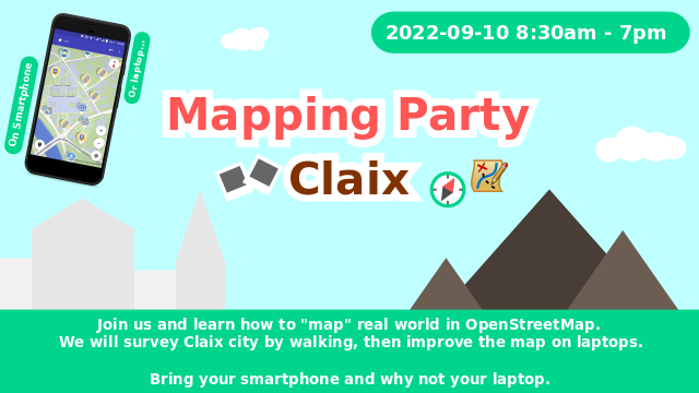
On Saturday September 10th 2022 , the OSM local group of Grenoble organized a mapping party in Claix, Isère, France. We were about 10 mappers and we survey this city of 8 000 inhabitants.

Mapping party

We used the tag #CARTOCLAIX2022. Below the area covered by all our changesets:

See full entry

Location: Le Bourg, Claix, Grenoble, Isère, Auvergne-Rhône-Alpes, Metropolitan France, 38640, France
Posted by mvexel on 16 September 2022 in English.

There was an interesting discussion following my recent diary post asking about searching diary content. A couple of people remarked that most search engines have built-in syntax that lets you narrow down search results. One person suggested that it might be enough to just mention this on the OSM wiki. When I went to add this tip, I found that there was no wiki page describing User Diaries at all. So I created an initial version. I’m writing this in hopes that others will go in and help improve it. Thanks, and happy mapping!

Location: Central City, Salt Lake City, Salt Lake County, Utah, United States

It has been almost a month since the annual State of the Map (SoTM) and Free and Open Source Software for Geospatial (FOSS4G) 2022 conferences, but the stories and experiences are still fresh in my memory. Both were the most awaited conferences in the open mapping and open software world and, undoubtedly, the best conferences I have attended.

SoTM and FOSS4G conferences were hybrid – held in Florence, Italy, and online. SoTM2022 was held last Aug 19-21, 2022, while FOSS4G took place on Aug 22-28, 2022. On top of the conference sessions and workshops, different organizations hosted additional events, like the HOT unSummit, and the YouthMappers documentary premiere. GeoChicas also hosted their social night.

firenze

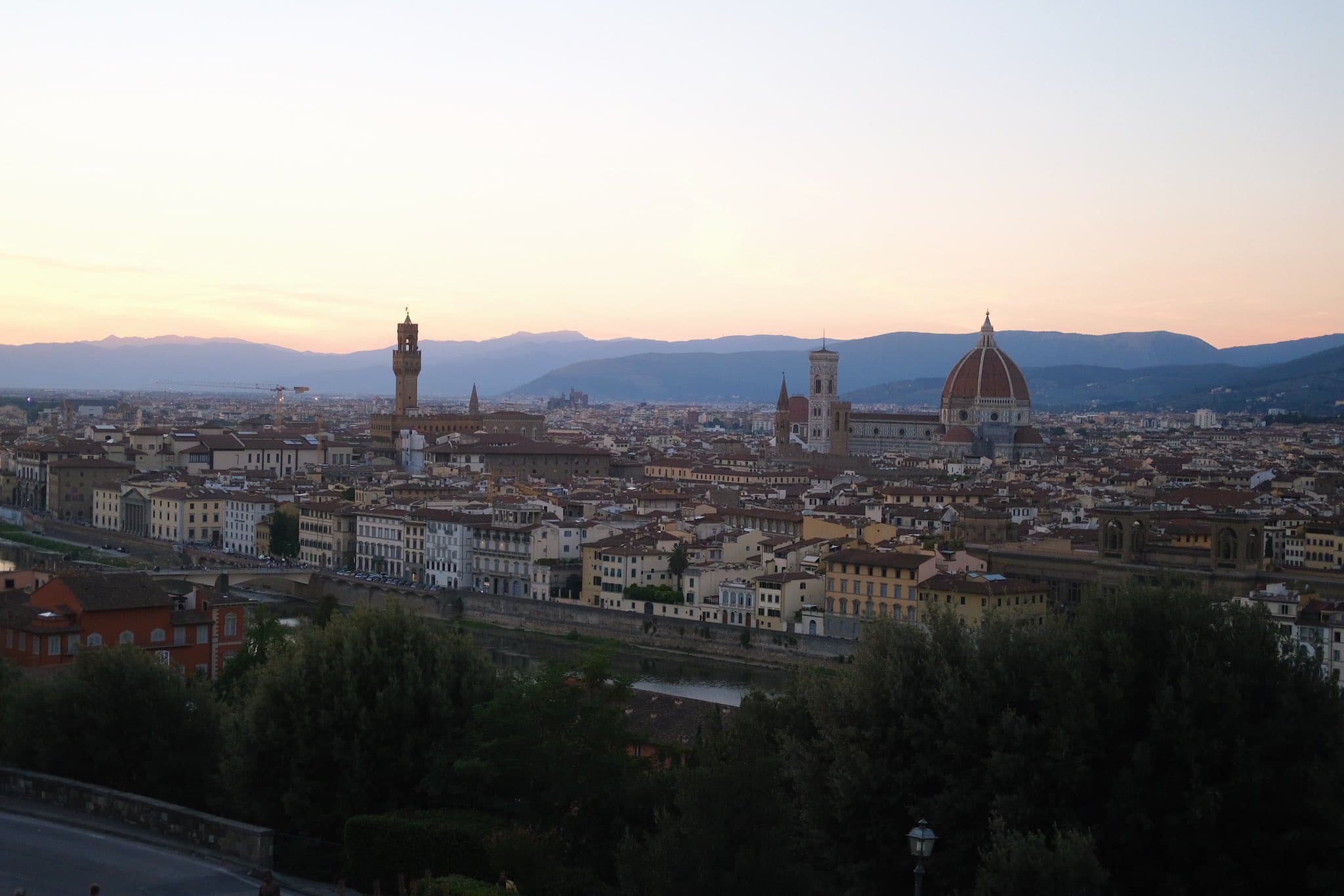
The beautiful sunset in Firenze, taken at Piazzale Michelangelo

See full entry

Posted by ghost_07 on 16 September 2022 in English.

Hi all,

Actually, this note is mostly just for me. One of the approved aerial imageries for sweden is the one used by Min Karta. Just use this as a custom imagery:

https://minkarta.lantmateriet.se/map/ortofoto/?BBOX={bbox}&FORMAT=image/jpeg&HEIGHT={height}&LAYERS=Ortofoto_0.5,Ortofoto_0.4,Ortofoto_0.25,Ortofoto_0.16&REQUEST=GetMap&SERVICE=WMS&SRS={proj}&VERSION=1.1.1&WIDTH={width}

Best regards and peaceful mapping, Dmitry

Posted by Mukesh J on 15 September 2022 in English.

How did it end?

To be honest, the experience was different than I expected. It was a lot of struggle to understand the codebase. The feature in itself was not too complex but understanding the code to a point where I made substantial progress did take a lot of time and effort.

With most real-world large projects, the outcome (the lines of code) produced at the end doesn’t depict an accurate picture of the hours a developer spent behind the scenes. But that’s with most creative jobs, I guess.

In the end, I am glad I was able to complete it. Seeing the feature work did make it up.

You can find my final report in a GitHub gist

If you are interested in how I understood the codebase, you can see

Should you contribute to open source?

OpenStreetMap (OSM) is a good product. Just try to edit your home or your neighborhood or any place you like using iD editor; you’ll realize what I mean. If not for open source, OSM wouldn’t exist.

If you are thinking of becoming part of Google Summer of Code (GSoC) in the future or know someone who can be or wants to be a part of GSoC or just wants to contribute to OSM or any open source project, I recommend it.

Note: relations in brackets [ ] are not part of the Empire State Trail, but are relations that were helpful in creating the trail.

Note: in this list, some relations have distances indicated after the relation ID number.

Top Level Relations

Sub-relations

See full entry

Posted by mvexel on 14 September 2022 in English.

I was going to search to see if someone had already written about this, but..

It would be really useful to be able to search the diaries.

There is so much valuable, fun, informative, personal writing on here, but it is really hard to discover.

Fortunately, Weekly OSM does a good job of capturing some of the interesting entries posted here, but they can’t possibly cover everything.

I’m not sure what would be involved in adding this functionality, I am sure if it were easy, someone would have already done it. Someone did open an issue for it on Github but it has received no comments so far.

Is there anyone here who speaks Ruby, cares about this, and wants to implement it?

Location: Liberty Wells, Salt Lake City, Salt Lake County, Utah, United States
Posted by Pieter Vander Vennet on 14 September 2022 in English. Last updated on 15 September 2022.

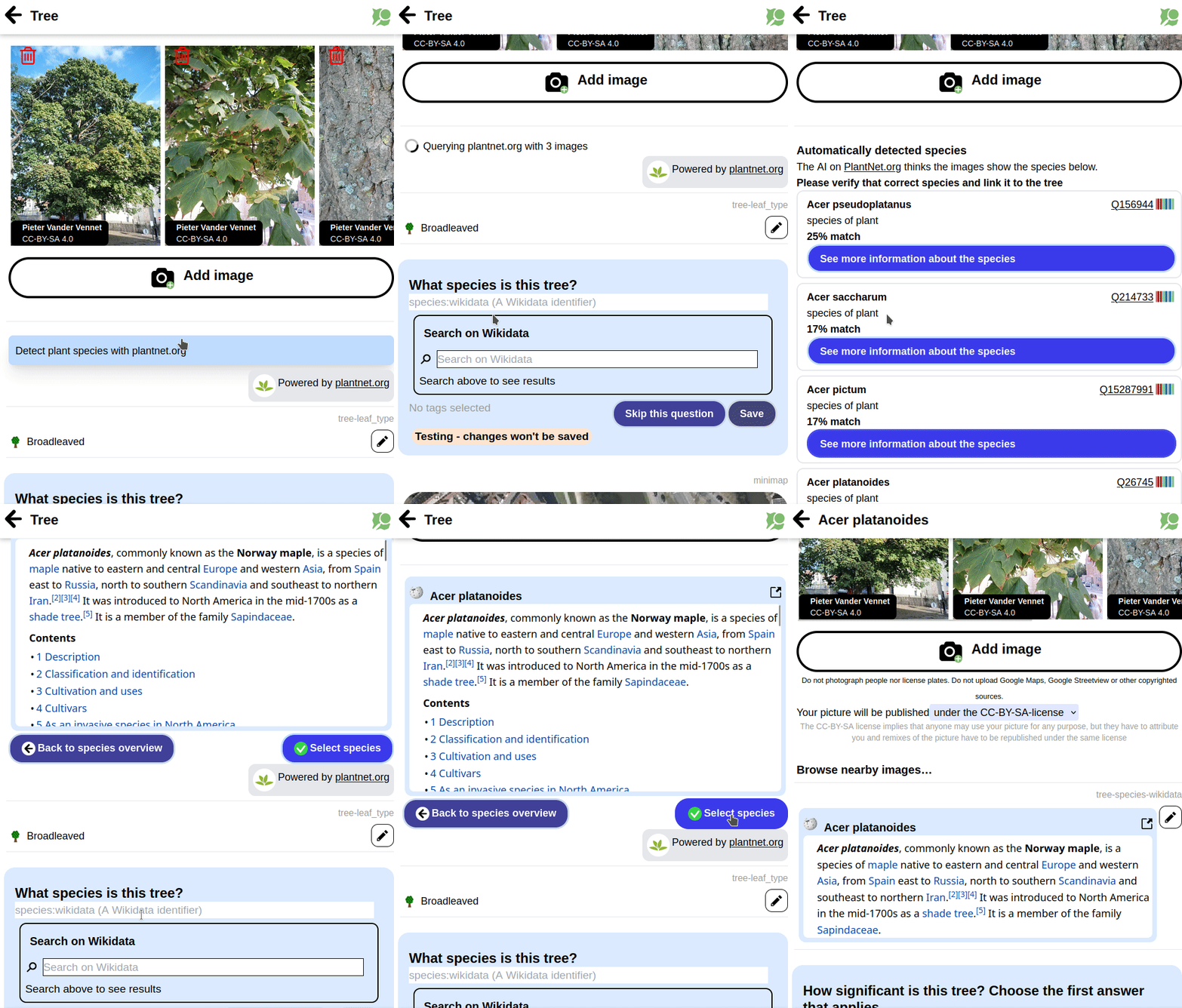
PlantNet.org offers an API which tries to determine the plant species based on some pictures.

I integrated this API into MapComplete, together with some queries to Wikidata. As a result, linking a tree to the correct species identifier is easier then ever and can be done with a few clicks:

Posted by Zverik on 14 September 2022 in English.

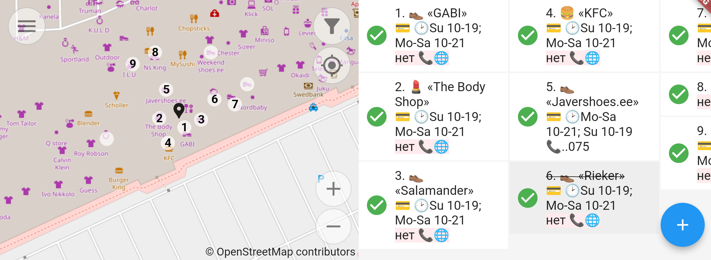
How Every Door looks while mapping a mall

This week I’ve released the 2.0 version of Every Door, which irons out most of the inconveniences found within a month after its official release. Yes, the editor has been officially released, just a few days before two talks on it at SotM and FOSS4G (recordings pending). You should download the editor for your Android or iOS smartphone right now!

I absolutely love the experience it gives me. It has revived my love for plain mapping, going out and collecting things to put on the map. Pascal’s HDYC shows my mapping days went from 29 last year to over 120 this year. That’s because I again look around for unmapped things while outside, and making an edit no longer requires navigating a map on a small phone screen, or making scribbles to open JOSM later at home.

See full entry

(Sorry for the delay in posting. I spent most of July 2022 on holiday in Australia)

  • Mapping
    • Livnig in Germany, I’m used to lots being mapped. In Australia there was so much to map!
      • I got to rank #151 in Australia (🐦 🐘) just from my day to day mapping.
      • To my shame, I did use Google Maps. There was so much missing PoIs from OSM.
    • A shop (which I spent a lot of money in) was selling dresses with “he/they” pronoun badge, and I wondered if clothes=women still applied 🐘 🐦. 🤣
  • OSMF Board
    • Board Meeting, July 2022 Board Meeting
      • I had just retured from Aus, and the postponed community presentation from Mapbox Workers Union was interesting.
      • It was interesting to find out that the Mapbox management hadn’t put any direct or explicit pressure on employees to vote a certain way at OSMF Board elections
      • Lots of Mapbox based maps don’t show OSM Attribution, and it was interesting to find that the union had tried to change that internally.
    • I didn’t go to the 2022-07 mid month chat because I was away in Australia (timezones!).
    • I started the wiki page for the board AMA at SotM 2022
  • Community
  • CWG
    • Freebies / Promotional Material Programme
      • I’ve been so bad with this lately, I’m sorry. I have requests from months ago that haven’t been sent out.
    • Instagram still posting there
    • Pinterest haven’t posted there as much lately.

Previously…

See full entry

Posted by mvexel on 13 September 2022 in English.

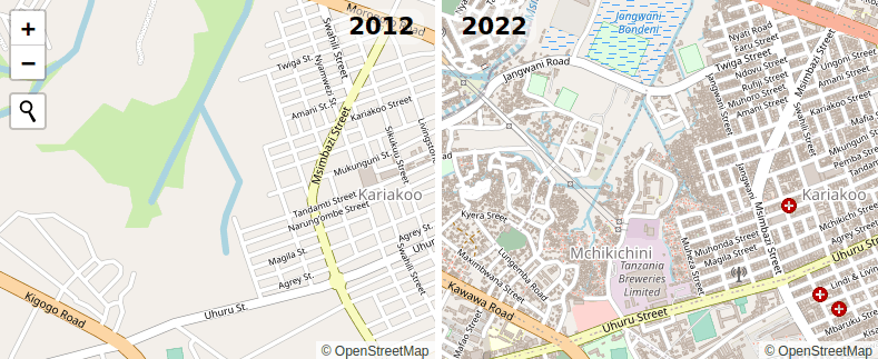
Ilya wrote about the 10th anniversary of OSM adopting the ODbL license yesterday. He has a cool 2012-2022 map compare web site to go with it. It’s incredible to see what we, the OSM community, have accomplished building our map in 10 years.

Ilya is a pretty technical guy and it’s not a huge thing for him to set up an OSM tile server from scratch. But what if you want to create something similar and you’re perhaps not quite that technical? If that’s you, I have something you might be interested in! It’s a little open source project on Github called openstreetmap-vintage-tile-server. With it, you can create a side-by-side map in a few pretty simple steps. The README on Github explains it pretty well, so I won’t repeat it here, but the steps are basically:

  1. Make sure you have docker and osmium installed
  2. Download a full history planet for the area you’re interested in (Geofrabrik has these, but you have to log in with your OSM account)
  3. Run the script

When it finishes, the tiles should be available on your local machine. The script will give you the URL to go to. There’s also an HTML example that you can use to create an interactive side by side map like this:

See full entry

Location: Central City, Salt Lake City, Salt Lake County, Utah, United States
Posted by Roberto Boberto on 12 September 2022 in English. Last updated on 13 September 2022.

Hi from Syria

I’m very impressed by the achievements of all the OSM contributors and as an IT student it was very nice to see how all this tooling is open-source.

I found OSM while searching for alternatives to Google Maps, that’s mainly because our country is sadly under restriction from the high majority of services provided by US companies.

And even if it was not for the restrictions, it would be for the price.

So I’ve found OSM and started diving step by step in it’s wiki. Until I was able to understand how the map can be mirrored, rendered and customized.

Then with some checks of my local area I wanted to do some edits as an experiment and oh god the tooling is amazing.

Huge thanks for everyone who worked on OSM whether on it’s software, organization or even contributed to it’s database!!

As a start I marked some appartement buildings, lets so how this goes.

Posted by Zverik on 12 September 2022 in English.

Dar es-Salaam in 2012 and 2022

Ten years ago on this day we changed the license for our data to ODbL, Open Database License 1.0. That was the final action of the lengthy relicensing process, which followed an exciting show of redacting and remapping the planet.

In July 2012 we started every day with watching the redaction progress map, discussing how the redaction bot devoured our precious map data, and making memes on the way.

After the bot finished its work, we started remapping everything we had lost. Poland and Australia were particularly broken, but most other countries had their losses. Alas we could not make everybody agree to the new contributor’s terms, so some mapping had to be done twice. But the work went better than expected, and it was then when we felt that the community is more important than the map, and that OSM can survive the loss of the latter.

See full entry

Namaste from Nepal,

Even though it has been two weeks since I returned from the conferences, the memories still seem fresh. When I reflect back, I am filled with so many new experiences and learnings that will be hard to cover in this diary but I will try to summarize in highlights so that it’s not boring for you :).

First day at Florence

Landing in a new country for the first time far away from home, was an overwhelming journey. I want to express my gratitude to Poorni Badrinath and Hector for helping to make my first day in Florence easier. Before I could check in, they showed me about the city, and after waiting in line for at least five minutes, I got to enjoy the best sandwich in popular place called All’Antico Vinaio. Oh, the first day went much better than I had anticipated. And, the next day, SOTM started. The idea of badges for talking accessibility really amazed me. Kudos to the creativity! first day with amazing Poorni

SOTM 2022

See full entry

Location: Kathmandu-02, Kathmandu Metropolitan City, Kathmandu, Bagamati Province, 21255, Nepal
Posted by tareqpi on 11 September 2022 in English.

Hi everyone, this is the update on the final phase of my progress in enhancing Nominatim’s search results ranking.

Previous Diary Entries

To have a background understanding of the project, you can check the overview of the project followed by the project’s first phase down below.

  1. Project Overview
  2. Phase 1

Project’s Pull Request

To see the code of the project, you can check the pull request here.

Detailed Report of the Project

The detailed version of the report can be read here.

What Has Been Done

  • Enabled PostGIS to work with raster files
  • Nominatim CLI tool can now import OSM views data from the GeoTIFF file
  • Nominatim CLI tool has the ability to refresh the OSM views data and recompute the importance scores
  • Integrated OSM views data into the algorithm that computes the places’ importance scores which are used in ranking Nominatim’s search results
  • Added some unit tests
  • Updated the documentation and added a detailed report of the experiments conducted

Possible Next Steps

There is a weak correlation between the OSM views data and the wiki importance data. A number of possible reasons have been outlined in the detailed version of this report in which further investigation is needed to have a better understanding of this outcome. Apart from that, the OSM views import feature can be enhanced so that the user can specify the zoom level when importing the data, or even have multiple zoom levels data imported one after the other so that the OSM views data have a higher degree of accuracy.

What I have learned

See full entry

Location: Taman Tun Dr Ismail, Kuala Lumpur, 60000, Malaysia