Diary Entries in English

Recent diary entries

Posted by Zverik on 14 August 2022 in English.

I know, Florence is too far away, and tickets are worth a fortune. I hesitated for weeks before shelling out 800 € for a flight and a hotel. That’s too much even for me, so I totally understand if you could not make it this year.

Thank gods for the Internet though! We are continuing with an option of virtual participation in SotM. Traditionally that have meant watching talks online and occasionally making people at the venue read your questions out loud. Not too fun when you have to concentrate on events happening thousands of kilometers away.

BUUUT this year we trying something different as well. First, passive participation: few people at the conference (or just me, we’ll see how it goes) would post photos and announcements and general impressions on everything going at and around the conference. It’s a way to get a glimpse at the experience of actually being there. I have done it in Russian for every SotM and FOSS4G and FOSDEM since 2016, and now I thought it might fit well into the virtual attendee package.

Also, active participation: record a video introduction of yourself and put it into the library of introductions. That way you can listen to people who attend the conference, either physically or virtually, and start a conversation with any of them. It is a magic tool that helps learn something about a person before approaching them: might help when you have an introvert’s anxiety (I should know!). And generally it’s fun: it highlights that a conference is not so much about talks and dinners, but about people first and foremost.

So, do buy a Venueless ticket at https://pretix.eu/osmf/SotM2022/ and join us: yes, you won’t be able to shake any hands or split a beer, but with a very little effort you can be a part of the conference.

Posted by SK53 on 12 August 2022 in English.

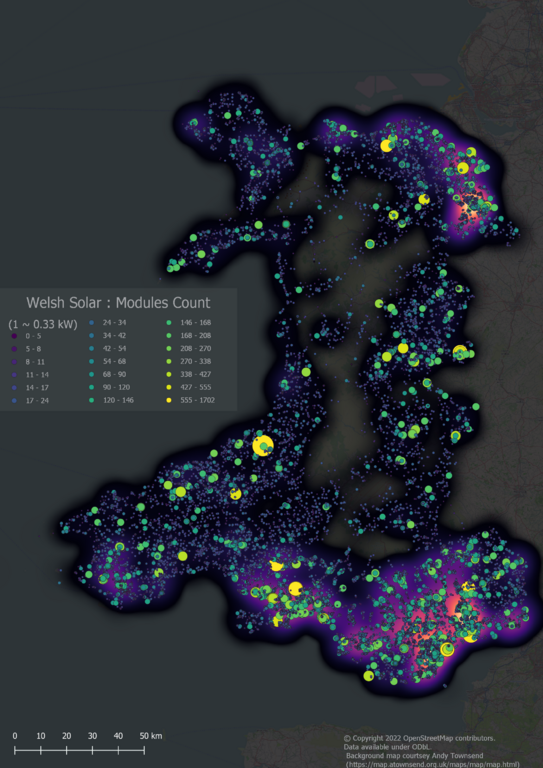
Back in March I was amused to see Amanda tweet that the UK OpenStreetMap community ran a solar power mapping project “several years ago”. This was the theme of the [quarterly project(osm.wiki/UK_2019_Q3_Project:_Solar_Power) in Q3 2019, but the project keeps trucking on.

Small-scale Solar Power in Wales; Heat map overlaid with individual solar arrays

All small-scale Solar Power in Wales (i.e., excluding solar farms of more than 1MW capacity)

In the past few days we reached a milestone of having comprehensive solar cover for Wales, one of the constituent countries of the United Kingdom. I think this is the first country to have solar power mapped at such a fine level of detail either on OSM or anywhere else.

The rest of this post discusses aspects of the how & why of this work.

Solar Mapping in the UK

See full entry

Location: Llannon, Carmarthenshire, Wales, United Kingdom
Posted by pnorman on 12 August 2022 in English.

Dear all,

Today, v5.6.1 of the OpenStreetMap Carto stylesheet (the default stylesheet on the OSM website) has been released. Once changes are deployed on the openstreetmap.org it will take couple of days before all tiles show the new rendering.

Changes include

  • Fixing rendering of water bodies on zooms 0 to 4

Thanks to all the contributors for this release.

For a full list of commits, see https://github.com/gravitystorm/openstreetmap-carto/compare/v5.6.0…v5.6.1

As always, we welcome any bug reports at https://github.com/gravitystorm/openstreetmap-carto/issues

Representing the federal government of traffic I would like to upload the 12 Routes of national cycling routes, representing the Cycle Network Germany. All data ist quality checked and free to use (Data licence Germany – attribution – version 2.0)

Looking for a contact to provide a boost for OpenCycleMap and OSM in general

Geodata is already published: https://www.radroutenplaner-deutschland.de/veraDaten_EN.asp

Location: Neustadt/Nord, Innenstadt, Cologne, North Rhine-Westphalia, Germany

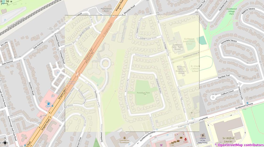
Toronto Police Service has major, systemic problems. But they also have this one:

TPS tweet image of Rowatson Park, Scarborough overlaid on OSM tiles in QGIS

This is my hastily-georeferenced version of the image from this Toronto Police Operations tweet over OSM tiles in QGis. Note the extreme similarity between the streets and building detail. But also note the complete lack of OSM attribution on TPS’s map …

Location: Guildwood, Scarborough—Guildwood, Scarborough, Toronto, Golden Horseshoe, Ontario, Canada

When preparing to embark on a hike, I want to know if a trail suitable for me (my skill level and the time/energy I have for the hike). I would like to review a map and have trails clearly identified based on their level of difficulty and level of required exertion. There are numerous classification systems which grade trails for hiking and mountain biking including the Swiss Alpine Club Rating scale, German Single-track Scale, International Mountain Mike Association scale, Yosemite Decimal System, Australian Walking Track Grading System, the Sierra Club scale, the Appalachian Mountain Club, and Shenandoah National Park and Pigeon Forge National Park, and the US Forest Service and others. These rating systems variously take into account surface condition and obstacles, steepness, trail visibility, required gear, required wayfarer skills, risk/exposure, length, and elevation change.

Several of the established scales focus on exertion level based on length/elevation with different formulas but don’t take into account technical difficulty (National Park Service and Appalachian Mountain Club, Sierra Club). Several focus terrain and skill required with criteria for peak and/or average incline, surface material, smoothness, visibility, required gear, and risk/exposure (SAC, MTB, YDS, and USFS). While others combine these factors (Australian System, and Adventure Nerds). Others have proposed modifications/alternative scales that have not been widely adopted, but attempt to merge and isolate key factors.

See full entry

Posted by mariotomo on 7 August 2022 in English. Last updated on 9 August 2022.

A note to myself

This is a note I’m writing to myself, but sharing it to the wider OSM community. I’m a great fan of OSM as a close-to-perfect means for producing this beautiful free geographic database we have, and I like Telegram as an informal platform. I’ve been using Telegram while discussing OSM changesets with fellow mappers, switching from changeset comments that were slowing down the communication, being less interactive and not letting us share images.

me on Telegram

On Telegram I founded the Comunidad OSM Panamá (let’s call it COP here), to which I’ve been inviting mappers who start contributing OSM data in Panama. I have also been made owner of the OpenStreetMap Off Topic (OOT) group, a quite diversified community of mappers who sometimes want to talk about anything else but mapping. In both groups I implement a very simple set of rules: 1) introduce yourself when you enter; 2) assume and practice good faith; 3) try to be nice to each other.

the CoC

In particular in the OOT group we have discussed some meta-issues, like when the OSMF was discussing the need for a formal Code of Conduct. From those discussions, I distilled my personal reasons for decidedly contrasting the formalization of “norms”, on top of what should be shared “values”: if we don’t agree on values, there’s no set of norms that will keep us together. Also, should we once agreed on a set of norms, we would need a group of enforcers, and while on the OSM platforms we have the OSM Foundation to perform that role, on Telegram we are outside the Foundation’s jurisdiction. Cutting it short, in my opinion, if we need the protection offered by the OSM Code of Conduct, we must stay on OSM services.

an event on official channels

See full entry

Posted by coolmule0 on 6 August 2022 in English. Last updated on 8 August 2022.

Microsoft have recently released their “Worldwide building footprints derived from satellite imagery”. This is a dataset containing the shape and positions of houses. It covers many parts of the world and is derived from Bing aerial imagery with the use of deep learning.

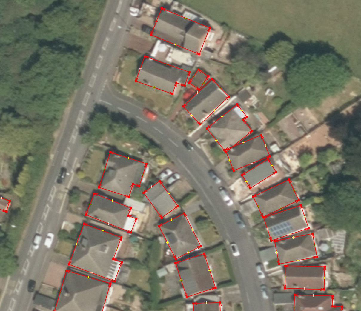
Data within JOSM

I find these footprints interesting for numerous reasons. The focus here will be to use the data to aid in mapping. There is further information on the OSM wiki.

In this diary entry I want to explain how I got the data into JOSM. In a following entry I will explain how I use this data to speed up building mapping.

Obtaining the data

The data is freely available on Github. It is licensed under ODbL and is compatible with OpenStreetMap. Each available country has its own zip file. Some of the files are of the order of gigabytes - far larger than can be opened in regular software. Pick a country and download the zip file.

Issues with the data

See full entry

Posted by b-unicycling on 3 August 2022 in English. Last updated on 5 August 2022.

Disclaimer: yes, I know, it’s absolutely micro mapping, but see “Side effects”.

It’s now been about 4 weeks since I started mapping thatched buildings in Ireland more systematically than just ad hoc adding roof:material=thatch whenever I saw one. I had focussed on Co. Kilkenny, because of a 1994 survey carried out by thatcher and archaeologist Jimmy Lenehan in that county, so all I had to do was revisit the sites and check whether the roof:material was still the same. I ended up visiting about 58 of of the 106 sites in his survey. (I tried to remember to add survey_date to those, so I could run an overpass query.)

He also told me about some newly thatched buildings, where I could add the tag, too.

I also had a long talk with him in his own thatched house which was a very interesting experience, because it was a very warm day (for Ireland), and the thatch really did insulate the house really well. He is not very good with technology, but I think he understood the potential of mapping the thatched buildings on an OpenData platform. I’ve added ref:IE:lenehan to the buildings from his survey and documented the tag in the wiki.

I also had a chat with our Heritage Officer who thought it was a good idea to undertake a new survey, but doesn’t seem to grasp the advantages of crowd sourcing and OpenData quite as much as I would hope. She is under the impression that I’m only doing a photographic survey, because I told her that I was uploading the photographs to WikiCommons (about 82 uploads for Co. Kilkenny so far). She asked if I would provide these images to their county archive as well, because “not everybody knows how to use that OpenData thing”. Well, everybody knows how to use Google, that should bring them to WikiCommons straight away. So I politely explained that and declined providing duplicate content. Needless to say, there is also no public funding for a survey this year, so I’ll just soldier on in my own time and out of my own pocket.

See full entry

Location: Clasharoe, Portnascully, The Municipal District of Piltown, County Kilkenny, Leinster, Ireland
Posted by DerZombiiie on 3 August 2022 in English.

no this is not about Minecraft, its about my non existent journey to map out Mainaschaff (my hometown) by the end of summer break (2nd week of September)

I already did 6-7 blocks today in around 2h which leaves me with more time than I have left to do the rest of the city.

So I’m stopping here…. for now.

If anyone wants to help me, feel free to just like…. make the map better.

Bye, nonexistent reader :)

Posted by pnorman on 3 August 2022 in English.

Dear all,

Today, v5.6.0 of the OpenStreetMap Carto stylesheet (the default stylesheet on the OSM website) has been released. Once changes are deployed on the openstreetmap.org it will take couple of days before all tiles show the new rendering.

Changes include

  • using locally installed fonts instead of system fonts, for more up to date fonts;
  • changing tree and tree row colours to the same colour as areas with trees;
  • rendering parcel lockers; and
  • rendering name labels of bays and straights from z14 only, and lakes from z5

Thanks to all the contributors for this release including GoutamVerma, yvecai, ttomasz, and Indieberrie, new contributors.

For a full list of commits, see https://github.com/gravitystorm/openstreetmap-carto/compare/v5.5.1…v5.6.0

As always, we welcome any bug reports at https://github.com/gravitystorm/openstreetmap-carto/issues

OpenStreetMap Carto could use more help reviewing pull requests, so if you’re able to, please head over to Github and review some of the open PRs.

Hey all,

In the past month, MapComplete was part of Open Summer of Code where 4 students and myself did make a lot of improvements and a new theme.

With this diary entry, I’d like to give you some insights in what we’ve done the past 4 weeks.

What is Open Summer of Code

Open Summer of Code (or OSOC) is a programme organized by Open Knowledge Belgium, which is a small belgian NGO that promotes Open Source and Open Data.

For OSOC, they search clients (organizations or governmental institutions) which have an interesting problem that they want solved and with budget to pay a team of about 4 students.

These 4 students will be guided by a coach (such as me) to make sure something useful comes out of it.

The actual problems are varied. We’ve had a planning tool for building new homes, a calendar application based on SOLID, a tool to discover research papers, …
The bottom line is that data must be open and that all produced software and tools will be open sourced. If possible, the programs should reuse existing tools and datasets, such as OpenStreetMap or wikidata.

OnWheels: the wheelchair accessibility map

One of the projects this year was paid for by BOSA (a belgian gov organization) requested by OnWheels - a belgian application which helps wheelchair users to navigate the world. They have a database of shops, restaurants and other amenties together with some info about them, such as name, contact details and opening hours, but also information about the width of the door, the height of the kurb at the entrance, …

During the past years, the idea of opening this data has grown within OnWheels, for various reasons. By opening the data, more people can reuse it. Furthermore, by switching to OSM, the cost of maintaining this data is shared amongst more people.

However, making the switch is not easy. With the OSOC-project, we wanted to create a first version of how an OnWheels 2.0 might work.

Whom is this app for?

See full entry

I have just returned from a no-toll way trip through France. What struck me was the widespread errors in speed limit tags, or the complete absence thereof, especially on a 90 kph or 80 kph stretch. Is somebody actually taking care of this in the France OSM editor group?

Location: Nantigny, Le Brethon, Montluçon, Allier, Auvergne-Rhône-Alpes, Metropolitan France, 03350, France
Posted by Patrik_B on 31 July 2022 in English. Last updated on 6 February 2025.

When you are reading this you should be already experienced with validating and using JOSM so I will not include basics here.

Validating multiple tasks at once or “Multivalidation”

Usually I am validating projects in HOT Tasking Manager that are focused on mapping buildings. I am going to show you an example of my workflow on one of the Mozambique projects because there are two things that are not in every project and it’s very easy to validate in this area so you can try it on your own. Since writing this diary the campaign ended but you can find similar projects using this filter on the HOT Tasking Manager

I highly recommend using the shortcuts in JOSM, which you can customize, or you can put tools that you are often using to your toolbar. I will write shortcuts for windows in { }.

For Multivalidation in Mozambique I am using these tools:

EXPERT MODE
Edit → Preferences {F12} → checkbox in the bottom left corner. Thanks to this you will be able to see some stuff that has been hidden before like the number of each layer, more options for Search or some tools like extrude tool for example. If you are using shortcuts (like {X} for extrude tool) those will work even if you won’t turn on the Expert mode.

PLUGINS
List of plugins that I am using and their most useful feature for me:

  • Buildings_tools - fundamental plugin for mapping buildings
  • Todo - great tool for adding buildings, task areas, anything into list and then easily check all of them one by one
  • Utilsplugin2 - mainly for Replace geometry {Ctrl+Shift+G}
  • Mapathoner - mainly for Selecting non orthogonal buildings
  • Markseen - mark seen areas of the map
  • Conflation* - basically Replace geometry for multiple objects at once. Since it is kinda tricky and doesn't have that much of a use I leave it here just as an honorable mention.

See full entry

While I tend to keep OpenCampingMap as it is showing only the facts acquired in Openstreetmap some people argue that users want to have reviews on this kind of maps and that this is what makes Google Maps or TripAdvisor so attractive.

This might be true. Thus I have now added a button to an external FOSS review Portal called Mangroove Reviews as a proof of concept.