Diary Entries in English

Recent diary entries

Posted by ngumenawesamson on 25 July 2022 in English. Last updated on 2 August 2022.

Background.

Even as OSM is rapidly growing in content and contributors, its credibility has been one of the main concerns for authoritative users. The belief that it is made by volunteers can limit the trust in the value of this free data source within traditional GIS communities. At HOT, we have prioritized the top 10 data quality aspects that we want to minimize. These aspects have been categorized under 3 categories the are Positional Accuracy, Semantic Accuracy, and Completeness.

We came to reach the top 10 list through a number of consultations with the Data Quality Working Group, representative from open mapping communities, and associates from HOT regional Hubs.

This information has been shared for reference by all OpenStreetMap data contributors, and users across the open mapping ecosystem, data quality associates at the HOT Regional Hubs, HOT partners and other communities that engage with OpenStreetMap.

HOT is focusing on prioritizing these aspects and implementation on how to minimize/eliminate them through HUB centered community engagements in form of trainings, collaborating with partners and developing tools that can be used to improve the quality of mapping.

There are many other issues affecting the quality of OSM data, however, our top 10 data quality aspects are;

1. Spatial offsets.

2. Temporal consistencies.

3. Feature tracing inconsistencies.

4. Road network consistency.

5. Completeness of health facilities.

6. Completeness of public service data for sustainable communities.

7. Administrative boundary inconsistencies.

8. Tagging.

9. Logical consistencies of map features.

10. Tasking Manager project consistencies.

===============================================================

1. Spatial Offsets:

An offset is the degree of deviation of an object from its intended position.

Category: Positional Accuracy

Possible Sources:

See full entry

This is a bit less OpenStreetMap related then normal, but has to do with the Standard Tile Layer and an outage we had this month.

On July 18th, the Standard Tile Layer experienced degraded service, with 4% of traffic resulting in errors for 2.5 hours. A significant factor in the time to resolve the incident was a lack of visibility of the health status of the rendering servers. The architecture consists of a content delivery network (CDN) hosted by Fastly, backed by 7 rendering servers. Fastly, like most CDNs, offers automatic failover of backends by fetching a URL on the backend server and checking its response. If the response fails, it will shift traffic to a different backend.

A bug in Apache resulted in the servers being able to handle only a reduced number of connections, causing a server to fail the health check, diverting all load to another server. This repeated with multiple servers, sending the load between them until the first server responded to the health check again because it had zero load. Because the servers were responding to most of the manually issued health checks and we had no visibility into how each Fastly node was directing its traffic, it took longer to find the cause than it should have.

Our normal monitoring is provided by Statuscake, but this wasn’t enough here. Instead of increasing the monitoring, we wanted to make use of the existing Fastly healthchecks, which probe the servers from 90 different CDN points. Besides being a vastly higher volume of checks, this more directly monitors the health checks that matter for the service

During the incident, Fastly support provided some details on how to monitor health check status. Based on this guide, the OWG has set up an API on the tile CDN to indicate backend health, and monitoring to track this across all POPs.

See full entry

During a hike I noticed that a small wooden chapel in a wood in Sudtirol, northern Italy, was placed incorrectly.

I made an exact point (8m precision) with two different apps which average the GPS points; I used 100 points. Latitude/longitude were 46.7138607/12.3411447 , just to be clear; I wanted to move the Kapelle at that position.

However, I found no way of directly entering the coordinates in the description of the point using the ID online editor. I had to resort to trial and error with the openstreetmap standard viewer, repeatedly using right-click/show address to obtain coordinates.

I tried to export data from the apps, but the format was rejected - apparently OSM expects polylines and not single points.

Is there any way to use this detailed information in a direct way?

Thanks in advance to everybody who knows…

Location: Ladstatter, Schmieden - Ferrara, Sexten - Sesto, Pustertal - Val Pusteria, South Tyrol, Trentino – Alto Adige/Südtirol, 39030, Italy
Posted by TrickyFoxy on 23 July 2022 in English. Last updated on 24 July 2022.

This is an auto-translation of my message from May 8 in the Russian-language OSM chat https://t.me/ruosm/648650

I will try to report some of the following. But now my goal is to say that registration in OSM is something that the already registered participants have forgotten about.


Suppose a person was not afraid and decided to register after all. Next is the real case.

One of the likely situations: a person learns about StreetComplete/EveryDoor and registers through them.

At first, for some reason, he is greeted by a page in English. Well, maybe the problem is in the browser. But why can’t I switch the language on the page?

Well, okay, he thinks, now I quickly register through social networks. Pokes into a conditional Google, gives access and is met by a form in which you need to enter mailS / login / passwordS. What the hell?! For the sake of a login? So just ask him.

Enters the login, password, clicks Register and after refreshing the page finds out that the login is already occupied, the passwords do not match. Enters a new username / password: the login is already there, the password is too weak. But you just need a little JS….

Then there are some agreements that no one reads and.... confirm the email address using the link in the email.

He waits for the letter, pokes at the link and if he still remembers why he did it, returns to the application, logs in and finally decides to upload his changes.

Sadness.


The issue of improving the registration form https://github.com/openstreetmap/openstreetmap-website/issues/3546

upd: Issue to simplify registration via Google https://github.com/openstreetmap/openstreetmap-website/issues/2287

Ticket about simplification of registration. It has been open since 2015! https://github.com/openstreetmap/openstreetmap-website/issues/894

Come in if you also think that registration needs to be simplified 🙏


See full entry

Posted by dónal on 21 July 2022 in English.

Quick recap from this month’s OSM Ireland Map&Chat.

Attendance: 4-5 contributors

Topics

Heritage trees in Ireland

Interesting to learn that the Tree Council of Ireland have a registry of trees and a number of trees have been classified as Heritage Trees. See https://data.gov.ie/dataset/heritage-trees-of-ireland

Brian H. wanted to know how to map these and it turns out there were no entries for heritage= so we fixed that by adding an entry for the Tree Council of Ireland. \o/

New building projects open on https://tasks.openstreetmap.ie/

The existing set of projects were mostly complete so Heikki mentioned that some new projects had been opened up. I started working on Leitrim since I know parts of the county quite well (lived in the neighbouring county of Sligo for a few years). Managed to get some easy tasks completed equating to 2% of the work. :)

Sledding hills in Toronto

Rob had a query about how to map a mound in Toronto he had seen. We concluded that man_made=mound was probably acceptable (some existing usage) but it turned out to be a sledding hill!! While there is no definitive tagging for these, we concluded that the tagging documented for Piste Maps is probably the best fit.

Location: Fearagh, Kilteevan Electoral Division, Roscommon Municipal District, County Roscommon, Connacht, Ireland
Posted by dónal on 21 July 2022 in English.

At the OSM Ireland Map&Chat in May 2022, a query arose about how to create maps for specific topics (one of the Irish contributors wanted to callout some memorial benches in their local area).

As a result of the discussion, I created a umap project to demonstrate some of the possibilities:
https://umap.openstreetmap.fr/en/map/kerry-pike-gaa-memorial-benches_765585#18/51.91009/-8.56102

The overpass api query that is plugged into the “Remote Data” url field is:

https://overpass-api.de/api/interpreter?data=[out:json][timeout:25];(node[%22amenity%22=%22bench%22](51.909338348825024,-8.562796711921692,51.9115654863502,-8.5586017370224);%20way[%22amenity%22=%22bench%22](51.909338348825024,-8.562796711921692,51.9115654863502,-8.5586017370224););out%20body;%3E;out%20skel%20qt;

Note: can actually be simplified since we know all the results will be nodes (above has nodes and ways. An exercise for the reader…

Overpass Turbo also has the ability to do something similar (limited control over display format though):

Overpass Query (with MapCSS): https://overpass-turbo.eu/s/1iBL
Interactive Overpass Turbo map: click here

For those looking to understand MapCSS a bit more, see osm.wiki/Overpass_turbo/MapCSS#Color_Coding

Location: Coolymurraghue, Kerry Pike, St. Mary's, Cork, County Cork, Munster, T23 A406, Ireland
Posted by Zverik on 21 July 2022 in English. Last updated on 23 July 2022.

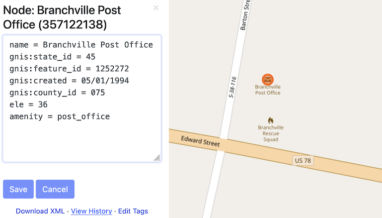
After my last State of the Map talk, some asked me where’s that “Edit Tags” button on the osm.org website, to quickly fix any tags without launching Level0? Of course there wasn’t one: I just quickly made up a text area with Firefox developer tools. But the idea was there.

Now I’m proud to show you that the button works, with a series of changesets to prove it. Alas, not in the website itself: to enable it, you must install a browser extension. Get yours for Firefox or for Chrome. After installing, open the iD editor once, and then look at any object page on osm.org.

This extension is a hack. It uses some undocumented things and will break when something changes in the code. Like, you need to first open iD editor for the authentication to work. If you don’t see the “Edit Tags” link, refresh the page. It is flimsy, but you can edit the map with it.

See full entry

Hi mappers! I have been on holiday near Como Lakes for the last few days. I visited the Forte Montecchio Nord, an old WW1 Fort really well preserved.

I like fortifications and I decided to re-map it, because the old work was fairly approximate. I also add a lot of information (contacts, opening hours…), that’s the result:

Before

The fort before

After

See full entry

Location: Stallone, Erbiola, Curcio, Colico, Lecco, Lombardy, 23823, Italy
Posted by плигаюча жабка on 19 July 2022 in English.

To my horror, I recently discovered I’ve misunderstood public transport route rules.

Now I’m sort of undoing some of the changes I’ve been painstakingly adding for the last week. Good grief.

So.

Things to have in mind:

  1. stops are the most important thing. and they have to be in order
  2. routes must be separate for separate directions
  3. roads are a bonus, but sometimes unnecessary to a transport route. (they are visually shown on maps, however)
  4. backwards/forwards direction in route planing is a scam. nobody needs it, so it might as well remain blank. why add it to technical options tho? idk. sigh

Where to look for more info:


that was a cry of a novice. If someone is interested in adding public transport, esp in Ukraine, please, dm me :)

Posted by Kento Kei on 19 July 2022 in English.

Given I rarely do these ‘diary entries’ and all I do is blabber on something barely anyone will care about, It’s time to talk about something more important than a random small town.

Basically, now that I have the ability to fully use JOSM, I am now in a place where I can begin to add large scale land use. I’ve decided to begin a test, and that’s to try to see how much land use I can add in a limited amount of time. Hopefully, from there, it will allow me to begin the actual big part of this whole entry;

I am planning on adding the natural land use (forests, farms, lakes, etc.) of southern Illinois. Not sure how far I’ll get, but if I can at least get the major counties done (Madison, St. Clair, and Jackson), I’ll call it a win.

Problem: Map a large volume of something that has distinct color.

Solution » High Level: * Highlight a sample square * Send a wanderer around in a perimeter * When the barrier is crossed, stop * Have the end user review

Solution » Low Level [LONG]: public main { //Describe sample square Let the user draw a square //Use sample square int minR, maxR, minB, maxB, minG, maxG; set all the mins to max value and all the max values to 0

for(every pixel in the square)
{
	does it need to be change one of the above 6 ints?
}

//Explore
while(endCondition not triggered)
{
	walk around the perimieter and send it to addSquare()
	if the addSquare says add it, send it to approvedSpots[][]
	else
	{
		ignore it
		but in future versions subdivide the square into 4 areas recursivley to minSizeOfArea;
	}
}

//Encase the area
Find our approved area and go to the top most point from the center.
Drop a point down
Go through the area, if 2 points are on the same line and not necessary, delete it. }

bool addSquare(all 6 rgb values, satteliteArea[][]) { //Filter out the blatantly false average out satteliteAreaRGB if satteliteArea violates the 6 rgb areas, return false.

//Check the square
for all the pixels, how many don't belong
percentDontBelong=numberDontBelong/howmany are in the satteliteArea
    Send it }

Concerns you might have: 1. Automation in OSM? The human has to: Define the sample and approve the result. 2. Junk Data: This would be a problem with a userbase, not a computational problem. We merely create tools. 3. What about non-90 degree angles? I agree that this would be a problem, I would hope someone made a tool that acts like the blender sculpt brush of smooth and bump, but for OSM.

See full entry

Location: Jackson Township, Shelby County, Iowa, United States
Posted by pnorman on 13 July 2022 in English.

Dear all,

Today, v5.5.1 of the OpenStreetMap Carto stylesheet (the default stylesheet on the OSM website) has been released. Once changes are deployed on the openstreetmap.org it will take couple of days before all tiles show the new rendering.

The one change is a bugfix to the colour of gates (#4600)

For a full list of commits, see https://github.com/gravitystorm/openstreetmap-carto/compare/v5.5.0…v5.5.1

As always, we welcome any bug reports at https://github.com/gravitystorm/openstreetmap-carto/issues

Posted by sahilister on 12 July 2022 in English. Last updated on 16 July 2022.

Chandigarh is a planned city here in north India. Since being well flocked by mappers and easy (fun) grid layout of roads, most of the areas are already mapped here. Last month, I came to the realization that many schools and colleges weren’t exactly mapped here.

There are a total of 115 government schools in Chandigarh (Primary-8, Middle-13, High School-53, Senior Secondary-40), seven aided schools, 37 recognized Senior Secondary private schools, 19 recognized private High Schools, 13 recognized private Middle Schools, 6 recognized private primary schools, and 3 recognized private play schools.

From - List of schools in Chandigarh - Wikipedia

The Wikipedia entry told me that there were quite a lot of work to be done, so I got to work. Got a todo list from Department of Education, Chandigarh Administration’s website. [1][2][3] I came to the realization vast majorities of school areas were already mapped and marked amenities=school some 9-10 years ago by Oberaffe, just that those lacked associated names and information of the institutions. Now getting the sector from DoE’s website and location from https://chandigarh.gov.in/know-chandigarh/map and referencing from Bharat Maps (which, by the way have surprisingly good mapping of schools), got me mapping. I just search for the school’s website and Wikipedia page, if it exists, and usually add the following tags -

  • name
  • name:en
  • alt_name
  • alt_name_1 (sometimes alt_name_2 also)
  • amenity
  • operator - usually educational societies
  • religion
  • website
  • phone
  • email
  • fax - weirdly, some schools still advertise them
  • grades - using 0-12 format where 0 signify pre-school - nursery/LKG/UKG
  • addr:postcode
  • addr:city
  • wikidata
  • wikipedia
  • source - which is usually website

See full entry

Location: Sector 22, Ward 3, Chandigarh, India
Posted by villasv on 12 July 2022 in English.

Today I was ables to swap out the pairing of OSM nodes and VSI stores. I’m now going over each VSI store and picking the closest OSM node with no threshold. Well, I am using a soft cap threshold of 1 km just to guarantee that the cross product of these two tables won’t explode, but no VSI store stays unmatched with that radius.

The analysis can be seen in this Data Studio dashboard.

As of now there are 140 good looking matches between OSM and VSI, basically half the dataset - much more than the initial count of 10%! I’ll go through these manually anyway just to confirm, because a few of them have a bit of a location discrepancy (>50 meters) and many have noticeable naming variations.

There are 138 non-matching pairs. There are a few of these that are just being missed by the name matching fuzziness logic, but most do seem to have significantly different names and locations. These will require a bit more survey work to sort out.

Posted by abdul_4ts on 12 July 2022 in English.

Shortly?

It was a year ago on yesterday (July 10, 2022) since I joined the OSM community. I would say it’s been nice to be a part of this awesome community that intends changing the world through open data provision.

Achieved?

  • Fact that I became a part of the community of free data provision
  • Meeting friends on the same endeavor in the community

On HOTOSM?

  1. Achieved both Intermediate and Advance Mapper status in my first year
  2. Mapped over 5k buildings, 100km waterways, 20km highways, close to 30 POIs, (on a close to 15hr mapping time)

It’s been GOOD

Location: Four Star Estates, Bomso, Oforikrom Municipal District, Ashanti Region, Ghana
Posted by villasv on 11 July 2022 in English.

Continued working on matching OSM nodes with VSI stores. There were 6 near-perfect matches (exact same name, points less than 10 m apart), but after introducing some fuzziness to the name comparison, that number jumps to 23!

I manually inspected those 23 pairs and indeed they seem to be referring to the same business. The matching remaining in the initial 10 m matching attempt is “49th parallel cafe & lucky’s doughnuts” in OSM vs “49th Parallel Coffee Roasters” in VSI. This one requires further inquiry to see if the OSM should really be updated or not.

I’m not totally satisfied with this 10 m threshold though. It’s arbitrary and not really what I’m looking after. I think I’ll redo the analysis but using “nearest VSI business within 100 m”, so that each OSM node will always match at most one VSI store and it won’t be so strict on the distance.

We had another great OSM meetup today in Perth (Western Australia). This time we were in Fremantle, where there’s lots of 19th century buildings that need address data and business information, as well as a fair bit of clearing up confusion about where one building ends and another starts. About eight people came.

We started in the café, fuelling up with coffees and pastries, and talking about how to map, what to map, and the general semantics of footpaths and roofs.

People sitting at an outdoor café table.

Then we wandered around for an hour and a half or so, splitting into two groups — one went down to the harbour and found lifebuoys, statues, and memorials to seafaring immigrants — the other attempted to add more detail to the University of Notre Dame’s campus, but actually ended up mostly working on addresses, businesses, and trying to make sense of building façades.

See full entry

Location: Fremantle, Western Australia, 6160, Australia
Posted by pnorman on 10 July 2022 in English.

Dear all,

Today, v5.5.0 of the OpenStreetMap Carto stylesheet (the default stylesheet on the OSM website) has been released. Once changes are deployed on the openstreetmap.org it will take couple of days before all tiles show the new rendering.

Changes include

  • Fixed colour mismatch of car repair shop icon and text (#4535)

  • Cleaned up SVG files to better align with Mapnik requirements (#4457)

  • Allow Docker builds on ARM machines (e.g. new Apple laptops) (#4539)

  • Allow file:// URLs in external data config and caching of downloaded files (#4468, #4153, #4584)

  • Render mountain passes (#4121)

  • Don’t use a cross symbol for more Christian denominations that don’t use a cross (#4587)

Thanks to all the contributors for this release, including stephan2012, endim8, danieldegroot2, and jacekkow, new contributors.

For a full list of commits, see https://github.com/gravitystorm/openstreetmap-carto/compare/v5.4.0…v5.5.0

As always, we welcome any bug reports at https://github.com/gravitystorm/openstreetmap-carto/issues